Portugal Elevation Map — Topographic & 3D Terrain
Explore the terrain of mainland Portugal in interactive 3D, built from Copernicus GLO-30 satellite elevation data — the Atlantic edge of Iberia, mountainous in the north, rolling to plains in the south. Drag to rotate, scroll to zoom, and tap any point to read its elevation.
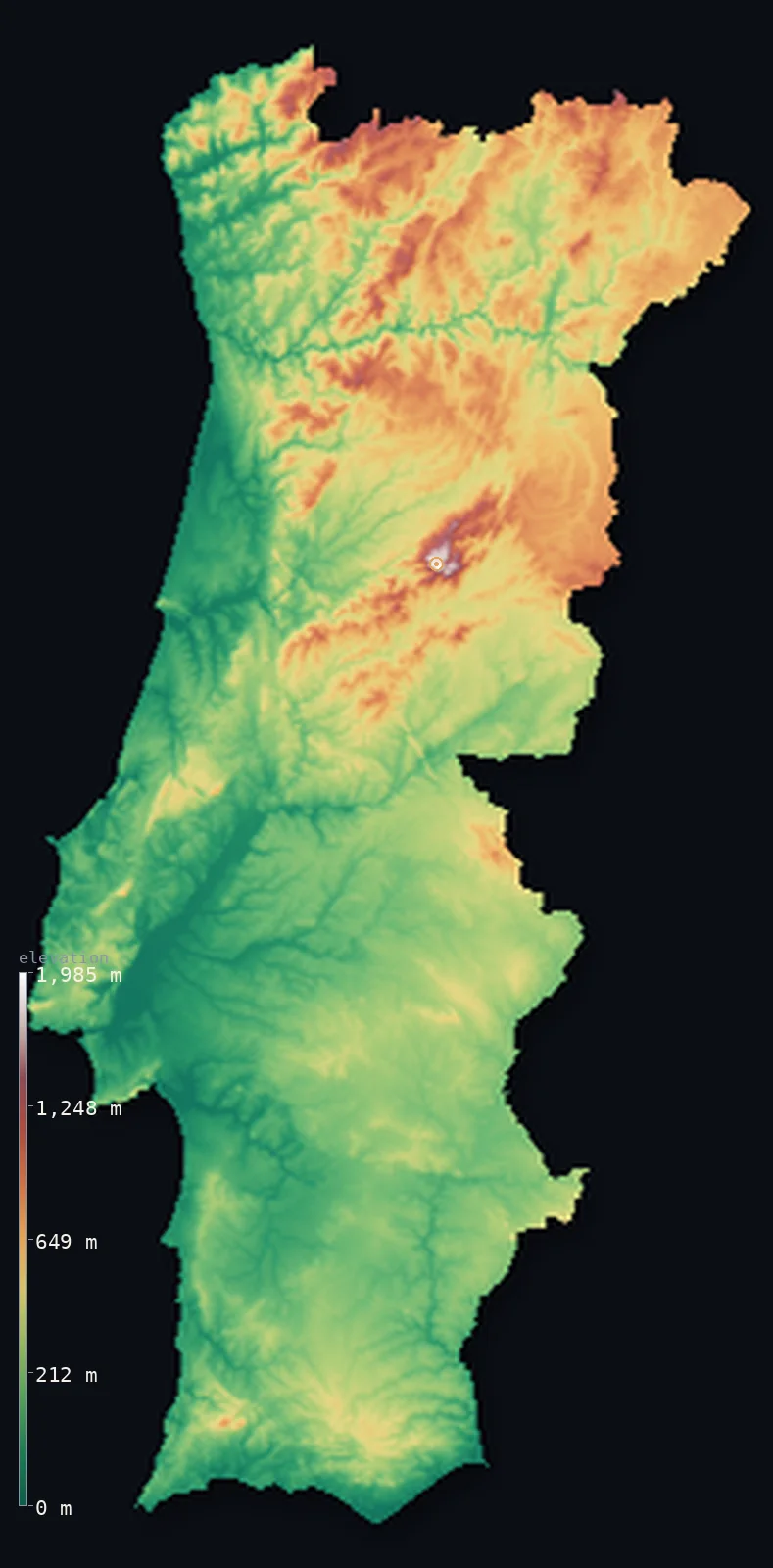
Portugal’s highest point is Torre at 6,539 ft (1,993 m); its lowest is Atlantic Ocean at 0 ft (0 m); the mean elevation is 1,043 ft (318 m).
Portugal faces the Atlantic down the western edge of Iberia, and the great rivers crossing it from Spain — the Douro, the Tagus, the Guadiana — divide it in two. North of the Tagus the land is higher and mountainous, rising to the Serra da Estrela, whose Torre summit at 6,539 ft (1,993 m) is the highest point of mainland Portugal. South of it the country opens into the rolling plains of the Alentejo and the hills of the Algarve. Higher still, out in the Atlantic, the volcanic island of Pico in the Azores tops the mainland — but it lies far off this map.
- Highest point📚
- 6,539 ft1,993 m
- The highest point of mainland Portugal is Torre, in the Serra da Estrela, at 6,539 ft (1,993 m) — the summit of the country's principal mountain range, high enough to hold snow in winter and carry Portugal's only ski resort. The highest point of Portugal as a whole is higher still: Mount Pico, a volcano in the Azores, reaches about 7,713 ft (2,351 m), but the mid-Atlantic islands lie far beyond this map, which shows the mainland.
- Lowest point📚
- 0 ft0 m
- Portugal's lowest point is the Atlantic Ocean at sea level, along a western and southern coastline of cliffs, estuaries, and beaches — the seaward edge of a country defined by its long Atlantic front.
- Mean elevation⚙
- 1,043 ft318 m
- Computed from the GLO-30 model, Portugal's mean elevation is 1,043 ft (318 m) — a moderate figure that reflects the country's split: the higher, mountainous north above the Tagus, and the lower, rolling plains of the south.
- Median elevation⚙
- 768 ft234 m
- Half of Portugal lies below 768 ft (234 m) — below the mean, the mark of a country weighted toward lower ground: the northern mountains lift the average, but the broad plains of the Alentejo and the river valleys make up much of the land.
- Elevation range📚
- 6,539 ft1,993 m
- From the Atlantic coast to the summit of Torre, Portugal spans about 6,540 ft — from sea-level shore to the snow of the Serra da Estrela, most of the height held in the mountainous north above the Tagus.
- Above 1,000 m (3,281 ft)⚙
- 2%
- About 2% of Portugal rises above 1,000 m (3,281 ft) — the higher ranges of the north and centre, above all the Serra da Estrela. The south, below the Tagus, is largely plain and hill and rises little.
- Official area📚
- 35,603 mi²92,212 km²
- Portugal covers about 35,600 sq mi (92,212 sq km) on the western edge of the Iberian Peninsula, with the Atlantic archipelagos of the Azores and Madeira — not shown on this map — extending the country far out into the ocean.
- Forest cover📚
- 36.2%
- About 36.2% of Portugal is forested — cork oak (of which Portugal is the world's leading producer), pine, and eucalyptus across the country, with the more wooded ground in the wetter, hillier north and centre.
Highest and lowest points
The highest point of mainland Portugal is Torre, 6,539 ft (1,993 m), in the Serra da Estrela — the country's principal mountain range, in the higher north-central interior. High enough to hold snow and carry Portugal's only ski resort, Torre is the summit of a broad, glacially-shaped upland. Portugal's absolute high point, though, is not on the mainland: Mount Pico, a volcano on the island of the same name in the Azores, rises to about 7,713 ft (2,351 m) — higher than anything in continental Portugal, but far out in the mid-Atlantic and beyond the frame of this map, which covers the mainland.
source ↗Portugal's lowest point is the Atlantic at sea level, along a coastline that runs the whole western and southern edge of the country — from the estuaries of the Douro and Tagus, where Porto and Lisbon stand, to the cliffs and beaches of the Algarve in the south. The Atlantic is central to Portugal's geography: no part of the mainland lies far from it, and the country's history has been shaped by facing the open ocean.
source ↗Portugal at a glance
The highest point of mainland Portugal, Torre (1,993 m) in the Serra da Estrela, holds the country's only ski resort — but Portugal's absolute highest point is Mount Pico (2,351 m), a volcano in the Azores.
source ↗Mount Pico in the Azores, an Atlantic volcano reaching 2,351 m, is the highest point of Portugal.
source ↗Portugal's great rivers — the Douro, Tagus, and Guadiana — all rise in Spain and cross the country to the Atlantic, dividing the mountainous north from the plains of the south.
source ↗Portugal is the world's leading producer of cork, harvested from the bark of cork oaks that cover much of the Alentejo in the south.
source ↗The Serra da Estrela, Portugal's highest mainland range, was shaped by glaciers in the last ice age and holds the country's only ski resort.
source ↗The Azores and Madeira, volcanic archipelagos far out in the Atlantic, are part of Portugal and extend the country hundreds of kilometres into the ocean.
source ↗
Elevation profile of Portugal
The largest share of land, 43%, falls in the 0–200 m band, and 78% of the territory lies below 500 m (1,640 ft).
- below 500 m (1,640 ft)78%
- 500–1,000 m21%
- 1,000–2,000 m2%
Highest peaks of Portugal
| Peak | Elevation | Range | Note |
|---|---|---|---|
| Ponta do Pico (Mount Pico)↗ | 7,713 ft2,351 m | Pico Island (Azores) | The highest point in all of Portugal, a stratovolcano in the Azores far out in the Atlantic. |
| Torre↗ | 6,539 ft1,993 m | Serra da Estrela (central mainland) | Highest point of mainland Portugal and of this map - a plateau summit in the Serra da Estrela. |
| Pico Ruivo↗ | 6,109 ft1,862 m | Madeira | The highest peak of Madeira island, third-highest in Portugal, in the Atlantic southwest of the mainland. |
| Serra do Geres (Nevosa)↗ | 5,069 ft1,545 m | Peneda-Geres (north mainland) | A high point of the northern highlands on the Spanish border, in Portugal's only national park. |
| Serra do Marao↗ | 4,642 ft1,415 m | Northern mainland | A granite range of the northern interior between the Douro and the coast. |
The mountainous north, the southern plains, and the Atlantic coast
The mountainous north
North of the Tagus, Portugal is higher and more rugged — a country of mountain ranges and deep river valleys, rising to the Serra da Estrela with Torre, the mainland's high point. The Douro cuts through it in a steep terraced valley famous for port wine. This is Portugal's cooler, wetter, more mountainous half.
The southern plains
South of the Tagus the land opens out — the broad, rolling plains of the Alentejo, warm, dry, and given to cork oak, wheat, and olive, and beyond them the hills and coast of the Algarve. Lower and gentler than the north, this is the country's open, sun-baked south.
The Atlantic coast and islands
Portugal's whole western and southern edge is Atlantic coast — estuaries, cliffs, and beaches, with Lisbon on the Tagus and Porto on the Douro. Far offshore lie the volcanic Azores and Madeira, mountainous mid-ocean islands that carry the country's absolute high point, Mount Pico — though they lie beyond this map.
How to read this map
Color shows elevation; the raised relief shows real terrain. On this map mainland Portugal reads as a country split north to south — browns and the white of the Serra da Estrela gathering in the mountainous north above the Tagus, giving way to the lower greens of the southern plains and the Algarve.
The 3D relief is the actual GLO-30 elevation data, exaggerated vertically so the northern mountains and the southern plains both show; the ×N relief slider controls how much. Tap anywhere to read that point's exact elevation.
City elevations in Portugal
Portugal's cities line the coast and the river mouths — Lisbon on the Tagus estuary, Porto on the Douro in the north, with Braga inland in the north and Faro on the Algarve coast in the south. Most sit low, near the Atlantic.
| City | Population | Elevation |
|---|---|---|
| Lisboncapitalthe capital, on the north bank of the Tagus estuary where the river meets the Atlantic ↗ | 517,802 | 194 ft59 m |
| Portoat the mouth of the Douro in the north, the country's second city ↗ | 252,687 | 272 ft83 m |
| Braga | 193,324 | 643 ft196 m |
| Coimbra | 140,796 | 282 ft86 m |
| Leiria | 128,640 | 118 ft36 m |
| Viseu | 103,502 | 1,470 ft448 m |
| Aveiro | 80,880 | 46 ft14 m |
| Faroon the Algarve coast in the far south ↗ | 70,347 | 69 ft21 m |
| Évora | 53,591 | 866 ft264 m |
| Guarda | 40,126 | 3,317 ft1,011 m |
Elevation sampled at each city centre from the Copernicus GLO-30 model. Cities and population from GeoNames (CC-BY 4.0).
Portugal in comparison
Portugal's terrain rises 6,539 ft (1,993 m) from sea level to Torre — about 23% of the height of Mount Everest, the world's highest point at 29,032 ft (8,849 m).
- Spain's mean elevation is 2,274 ft — 1,230 ft higher; its high point, Mulhacen, reaches 11,414 ft (3,479 m), 4,875 ft above. Spain elevation map →
- Ireland's mean elevation is 358 ft — 686 ft lower; its high point, Carrauntoohil, reaches 3,409 ft (1,039 m), 3,130 ft below. Ireland elevation map →
- Greece's mean elevation is 1,578 ft — 535 ft higher; its high point, Mount Olympus (Mytikas peak), reaches 9,573 ft (2,918 m), 3,035 ft above. Greece elevation map →
Frequently asked questions
What is the highest point in Portugal?
- The highest point of Portugal is Mount Pico, a volcano in the Azores, at about 7,713 ft (2,351 m) — but it lies far out in the Atlantic, beyond this map. The highest point of mainland Portugal is Torre, 6,539 ft (1,993 m), in the Serra da Estrela.
What is the lowest point in Portugal?
- The Atlantic Ocean at sea level, along the western and southern coasts.
What is the average elevation of Portugal?
- Computed from the Copernicus GLO-30 model, Portugal's area-weighted mean is 1,043 ft (318 m) — moderate, reflecting the split between the mountainous north and the plains of the south.
Why doesn't this map show the Azores and Madeira?
- The Azores and Madeira lie hundreds of kilometres out in the Atlantic, far from mainland Portugal — too distant to show on the same map at a useful scale. This map covers the mainland; Portugal's absolute high point, Mount Pico, is in the Azores.
What divides northern and southern Portugal?
- The river Tagus, broadly — north of it the land is higher and mountainous, rising to the Serra da Estrela; south of it lie the rolling plains of the Alentejo and the Algarve.
Is this a topographic, relief, contour, or elevation map of Portugal?
- They describe the same thing — terrain height. This page renders the mainland's actual elevation surface in interactive 3D and reports the statistics computed from it.
About this map
The terrain is rendered from the Copernicus GLO-30 digital elevation model (ESA), masked to the PRT-ADM0 boundary from geoBoundaries (gbOpen). Elevation statistics are computed directly from the model; peak names and researched facts are sourced and cited. See the methodology for the full pipeline.
Our area-weighted mean, computed from the Copernicus GLO-30 model, is 1,043 ft (318 m); the figure commonly cited elsewhere is 1,220 ft (372 m) (CIA World Factbook). Mainland Portugal divides at the Tagus into a higher, mountainous north and a lower, rolling south of plains and plateaus, giving a moderate mean elevation; the page reports the area-weighted figure computed from the Copernicus GLO-30 model over the rendered land.
Surveyed national figures: official area · forest cover · high point.
Rendered from Copernicus GLO-30 (ESA, 2021 release), boundaries from geoBoundaries. Generated 2026-06-26.
Bordering countries · 1
Portugal shares a land border with these countries — open any one to compare its terrain and highest point.