Ireland Elevation Map — Topographic & 3D Terrain
Explore the terrain of Ireland in interactive 3D, built from Copernicus GLO-30 satellite elevation data — a low central plain ringed by mountains along almost every coast. Drag to rotate, scroll to zoom, and tap any point to read its elevation.
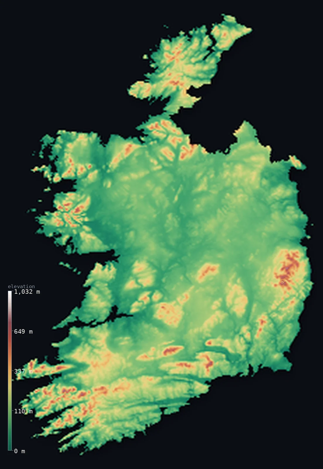
Ireland’s highest point is Carrauntoohil at 3,409 ft (1,039 m); its lowest is Atlantic Ocean at 0 ft (0 m); the mean elevation is 358 ft (109 m).
Ireland is shaped like a bowl. Mountains stand around nearly the whole rim of the island — Kerry in the southwest, Wicklow in the east, Connemara in the west, Donegal in the north — while the middle sinks into a broad, low limestone plain of bog, lake, and pasture. It is a low country: 61% lies below 328 ft (100 m), the mean is just 358 ft (109 m), and effectively none of it clears 3,281 ft (1,000 m), because the highest point, Carrauntoohil, only just passes it at 3,409 ft (1,039 m).
- Highest point📚
- 3,409 ft1,039 m
- Ireland's highest point is Carrauntoohil at 3,409 ft (1,039 m), in the Macgillycuddy's Reeks of County Kerry — a sandstone ridge in the far southwest, and effectively the only ground in the country that reaches past 1,000 m at all.
- Lowest point📚
- 0 ft0 m
- Ireland's lowest point is the Atlantic at sea level — never far off, since the island is ringed by coast and the low central plain reaches the sea through gaps in the mountain rim.
- Mean elevation⚙
- 358 ft109 m
- Ireland's mean elevation computed from the GLO-30 model is 358 ft (109 m) — very low, and a faithful description of a country whose interior is a broad plain and whose mountains are a thin border around the edge.
- Median elevation⚙
- 272 ft83 m
- Half of Ireland lies below 272 ft (83 m) — lower still than the mean, because the central lowland is so extensive and so flat that the coastal ranges barely lift the country's middle.
- Elevation range📚
- 3,409 ft1,039 m
- From the Atlantic to Carrauntoohil, Ireland spans only about 3,400 ft — one of the narrowest elevation ranges in Europe, and a reminder that the island's drama comes from its coastline rather than its height.
- Above 1,000 m (3,281 ft)⚙
- 0%
- Essentially none of Ireland rises above 1,000 m (3,281 ft) — only a handful of summits in the Macgillycuddy's Reeks pass that line, too small an area to register as even a fraction of a percent of the country.
- Official area📚
- 27,133 mi²70,273 km²
- Ireland covers about 27,000 sq mi (70,273 sq km) — this map shows the Republic of Ireland; Northern Ireland is part of the United Kingdom and appears on that page.
- Forest cover📚
- 11%
- About 11% of Ireland is forested — a low share by European standards. The island's original woodland was cleared over centuries, and much of what stands today is planted conifer on upland and bog.
Highest and lowest points
Ireland's highest point is Carrauntoohil, 3,409 ft (1,039 m), in the Macgillycuddy's Reeks of County Kerry — a steep sandstone ridge carved into corries and knife edges by ice-age glaciers, and one of the very few points in the country to break 1,000 m. Its modest height is deceptive: the Reeks rise almost directly from sea level on the Iveragh Peninsula, so the mountain feels far larger than its elevation suggests.
source ↗Ireland's lowest point is sea level, on an Atlantic coastline that does most of the work the mountains do elsewhere. In the west it is deeply indented — the drowned valleys and peninsulas of Kerry and Cork, the cliffs of Clare and Donegal — while the east faces the Irish Sea more gently. The central plain reaches the coast through gaps in the mountain rim, most notably around Dublin Bay and the Shannon estuary.
source ↗Ireland at a glance
Carrauntoohil, 1,039 m, is Ireland's highest point - and one of the only places in the country to pass 1,000 m at all.
source ↗Ireland is shaped like a bowl: mountains ring almost the entire coast while the middle of the island is a broad, low limestone plain.
source ↗About 61% of Ireland lies below 100 m - the central lowland is so extensive that the country's mean elevation is only around 109 m.
source ↗The Burren in County Clare is a vast exposed limestone pavement, stripped bare by glaciation, with a flora found nowhere else in the same combination.
source ↗Bogs cover a substantial share of the Irish midlands - raised and blanket peat built up over thousands of years on the poorly drained plain.
source ↗Ireland's mountains are made of hard, ancient rock left standing as the softer limestone of the interior wore away - which is why the high ground sits at the edges.
source ↗No part of Ireland lies more than about 110 km from the sea.
source ↗
Elevation profile of Ireland
The largest share of land, 61%, falls in the 0–100 m band, and 99% of the territory lies below 500 m (1,640 ft).
- below 500 m (1,640 ft)99%
- 500–1,000 m1%
Highest peaks of Ireland
| Peak | Elevation | Range | Note |
|---|---|---|---|
| Carrauntoohil↗ | 3,409 ft1,039 m | MacGillycuddy's Reeks (Kerry) | Highest point of Ireland, the central peak of MacGillycuddy's Reeks in the southwest. |
| Beenkeragh↗ | 3,307 ft1,008 m | MacGillycuddy's Reeks (Kerry) | Ireland's second-highest peak, linked to Carrauntoohil by a narrow arete. |
| Caher↗ | 3,284 ft1,001 m | MacGillycuddy's Reeks (Kerry) | Ireland's third-highest peak, on the ridge west of Carrauntoohil. |
| Mount Brandon↗ | 3,123 ft952 m | Brandon Group (Dingle Peninsula, Kerry) | The highest peak outside MacGillycuddy's Reeks, on the Dingle Peninsula. |
| Lugnaquilla↗ | 3,035 ft925 m | Wicklow Mountains (east) | The highest mountain in Ireland outside the southwest, in the Wicklow Mountains south of Dublin. |
The bowl and its rim
The central lowland
The middle of Ireland is a wide, low plain of limestone, covered in glacial till, bog, lake, and pasture, and rarely rising above 100 m. The Shannon, the longest river in these islands, wanders slowly across it. This flat interior is the reason the country's elevation figures are so low.
The mountain rim
Almost every coast has mountains: the Macgillycuddy's Reeks and the ranges of Kerry and Cork in the southwest with Carrauntoohil, the Wicklow Mountains south of Dublin, Connemara and Mayo in the west, and Donegal in the northwest. Made of harder, older rock than the interior, they survived while the middle wore down.
The Atlantic coast
The western seaboard is deeply cut — long peninsulas, drowned valleys, sea cliffs, and thousands of islands — where the Atlantic has worked at the hard rock of the rim for millennia. It is the most dramatic terrain in a country whose heights are otherwise modest.
How to read this map
Color shows elevation; the raised relief shows real terrain. On this map Ireland reads as a green bowl — a low, almost uniform centre with browns gathering around the coastal rim, deepest in the southwest.
The 3D relief is the actual GLO-30 elevation data, exaggerated vertically far more than usual so that a country this low shows any shape at all; the ×N relief slider controls how much. Tap anywhere to read that point's exact elevation.
City elevations in Ireland
Irish cities sit low and coastal - Dublin on its bay, Cork on the Lee estuary, Galway on the Atlantic. In a country this flat, none of them stands more than a few tens of metres above the sea.
| City | Population | Elevation |
|---|---|---|
| Dublincapitalthe capital, on Dublin Bay where the central plain meets the Irish Sea ↗ | 1,024,027 | 52 ft16 m |
| Corkon the Lee estuary in the south, near sea level ↗ | 224,004 | 30 ft9 m |
| Limerick | 102,287 | 30 ft9 m |
| Galwayon the Atlantic coast at the western edge of the central plain ↗ | 85,910 | 33 ft10 m |
| Waterford | 60,079 | 39 ft12 m |
| Drogheda | 44,135 | 92 ft28 m |
| Carlow | 27,351 | 177 ft54 m |
| Tralee | 26,079 | 26 ft8 m |
| Athlone | 22,869 | 135 ft41 m |
| Droichead Nua | 22,742 | 302 ft92 m |
Elevation sampled at each city centre from the Copernicus GLO-30 model. Cities and population from GeoNames (CC-BY 4.0).
Ireland in comparison
Ireland's terrain rises 3,409 ft (1,039 m) from sea level to Carrauntoohil — about 12% of the height of Mount Everest, the world's highest point at 29,032 ft (8,849 m).
- United Kingdom's mean elevation is 528 ft — 171 ft higher; its high point, Ben Nevis, reaches 4,413 ft (1,345 m), 1,004 ft above. United Kingdom elevation map →
- Iceland's mean elevation is 1,657 ft — 1,299 ft higher; its high point, Hvannadalshnúkur, reaches 6,923 ft (2,110 m), 3,514 ft above. Iceland elevation map →
Frequently asked questions
What is the highest point in Ireland?
- Carrauntoohil, 3,409 ft (1,039 m), in the Macgillycuddy's Reeks of County Kerry - one of the only points in the country above 1,000 m.
What is the lowest point in Ireland?
- Sea level - the island is ringed by coast, and the low central plain reaches the sea through gaps in the mountain rim.
What is the average elevation of Ireland?
- Computed from the Copernicus GLO-30 model, the area-weighted mean is 358 ft (109 m) - very low, since the broad central lowland covers most of the island.
Why are Ireland's mountains all around the edges?
- The interior is soft limestone that wore down over time, while the coastal ranges are made of harder, older rock that survived - leaving a low centre ringed by high ground.
Does this map include Northern Ireland?
- No - this page shows the Republic of Ireland. Northern Ireland is part of the United Kingdom and appears on the United Kingdom elevation map.
Is this a topographic, relief, contour, or elevation map of Ireland?
- They describe the same thing - terrain height. This page renders the country's actual elevation surface in interactive 3D and reports the statistics computed from it.
About this map
The terrain is rendered from the Copernicus GLO-30 digital elevation model (ESA), masked to the IRL-ADM0 boundary from geoBoundaries (gbOpen). Elevation statistics are computed directly from the model; peak names and researched facts are sourced and cited. See the methodology for the full pipeline.
Our area-weighted mean, computed from the Copernicus GLO-30 model, is 358 ft (109 m); the figure commonly cited elsewhere is 387 ft (118 m) (CIA World Factbook). Ireland is a low-lying island - a broad central plain ringed by coastal mountains, with no point much above 1,000 m - giving a low mean elevation; the page reports the area-weighted figure computed from the Copernicus GLO-30 model.
Surveyed national figures: official area · forest cover · high point.
Rendered from Copernicus GLO-30 (ESA, 2021 release), boundaries from geoBoundaries. Generated 2026-06-23.
Bordering countries · 1
Ireland shares a land border with these countries — open any one to compare its terrain and highest point.