United Kingdom Elevation Map — Topographic & 3D Terrain
Explore the terrain of the United Kingdom in interactive 3D, built from Copernicus GLO-30 satellite elevation data — low, worn islands with old mountains in the north and west. Drag to rotate, scroll to zoom, and tap any point to read its elevation.
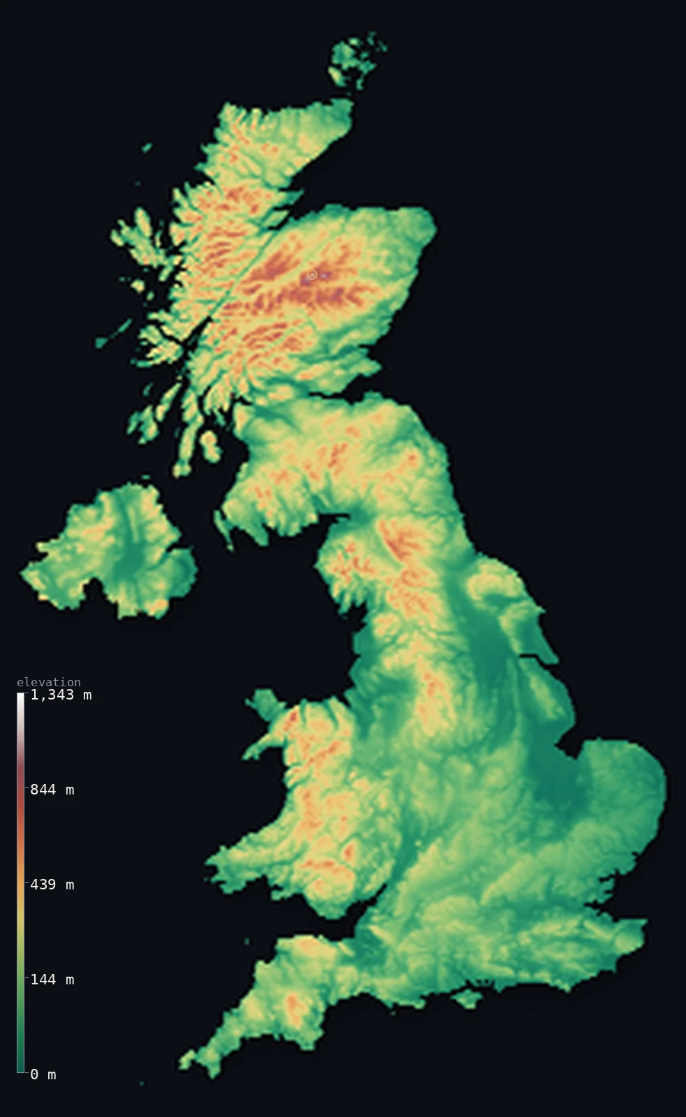
United Kingdom’s highest point is Ben Nevis at 4,413 ft (1,345 m); its lowest is The Fens at −13 ft (−4 m); the mean elevation is 528 ft (161 m).
The United Kingdom is a low country by any measure: about 96% of it lies below 1,640 ft (500 m), and its highest point, Ben Nevis, reaches only 4,413 ft (1,345 m). Its mountains are ancient and heavily eroded, worn down and then scoured by ice — highest in the Scottish Highlands, lower through the Lake District, the Pennines, Snowdonia and the hills of Northern Ireland, with the flat, fertile lowlands lying to the south and east.
- Highest point📚
- 4,413 ft1,345 m
- The United Kingdom's highest point is Ben Nevis at 4,413 ft (1,345 m), in the Scottish Highlands — a broken volcanic massif rather than a peak, its summit plateau often in cloud, and modest by continental standards despite being the roof of the country.
- Lowest point📚
- −13 ft−4 m
- The UK's lowest point is in the Fens of eastern England, about 13 ft (4 m) below sea level — drained peat marsh that has sunk as it dried, kept farmable now only by pumps and embankments.
- Mean elevation⚙
- 528 ft161 m
- The United Kingdom's mean elevation computed from the GLO-30 model is just 528 ft (161 m) — low even for an island nation, because the great bulk of England lies in gentle lowland and only the northern and western fringes carry any real height.
- Median elevation⚙
- 364 ft111 m
- Half of the UK lies below 364 ft (111 m) — a very low median that captures the country's true character: rolling lowland and modest hills, with genuine mountain terrain confined to Scotland, north Wales, and the northwest of England.
- Elevation range📚
- 4,426 ft1,349 m
- From the Fens below sea level to the summit of Ben Nevis, the UK spans only about 4,430 ft — one of the narrowest elevation ranges of any sizeable country in Europe, the legacy of very old mountains ground down over hundreds of millions of years.
- Above 1,000 m (3,281 ft)⚙
- <1%
- Almost none of the United Kingdom is high: barely any of the country rises above 1,000 m (3,281 ft), and those few summits are all in the Scottish Highlands. About 96% of the land lies below 500 m.
- Official area📚
- 94,058 mi²243,610 km²
- The United Kingdom covers about 94,000 sq mi (243,610 sq km) across Great Britain, Northern Ireland, and many smaller islands — a compact, densely settled country with a very long coastline for its size.
- Forest cover📚
- 13.2%
- Only about 13% of the United Kingdom is forested — among the lowest shares in Europe, the result of many centuries of clearance for farming, grazing, and timber, with most surviving woodland now planted rather than ancient.
Highest and lowest points
The United Kingdom's highest point is Ben Nevis, 4,413 ft (1,345 m), near Fort William in the Scottish Highlands. It is the eroded remnant of an ancient collapsed volcano, its summit a boulder-strewn plateau that is in cloud most days of the year, with a great cliff face on its north side that is one of Britain's most serious mountaineering grounds. It is the highest of the Munros, Scotland's peaks above 3,000 feet.
source ↗The United Kingdom's lowest point is in the Fens of eastern England, about 13 ft (4 m) below sea level near Ely in Cambridgeshire. This was once tidal marsh and peat bog; drained from the 17th century onward for farmland, the peat dried, shrank, and sank, leaving some of Britain's most productive soil lying beneath the level of the sea and dependent on a permanent system of drains, embankments, and pumps.
source ↗United Kingdom at a glance
Ben Nevis, 1,345 m, is the UK's highest point - the eroded remains of an ancient collapsed volcano, with a summit plateau in cloud most days of the year.
source ↗About 96% of the United Kingdom lies below 500 m - its mountains are ancient and heavily worn, with almost no ground above 1,000 m.
source ↗The UK's lowest point, in the Fens of eastern England, lies about 4 m below sea level - drained marshland that sank as its peat dried out.
source ↗Scotland's peaks above 3,000 feet are known as Munros, and there are 282 of them - almost all the UK's high ground is Scottish.
source ↗Only about 13% of the United Kingdom is forested, one of the lowest shares in Europe after centuries of clearance.
source ↗Britain's landscape was shaped by ice ages that scoured the north and west into glens, lochs, and cirques while leaving the south and east as gentler lowland.
source ↗
Elevation profile of United Kingdom
The largest share of land, 45%, falls in the 0–100 m band, and 96% of the territory lies below 500 m (1,640 ft).
- below 500 m (1,640 ft)96%
- 500–1,000 m4%
- 1,000–2,000 m<1%
Highest peaks of United Kingdom
| Peak | Elevation | Range | Note |
|---|---|---|---|
| Ben Nevis↗ | 4,413 ft1,345 m | Grampian Mountains (Scotland) | Highest point of the United Kingdom and of Scotland, near Fort William. |
| Ben Macdui↗ | 4,295 ft1,309 m | Cairngorms (Scotland) | The second-highest mountain in the UK, in the Cairngorms plateau. |
| Snowdon (Yr Wyddfa)↗ | 3,560 ft1,085 m | Snowdonia (Wales) | The highest mountain in Wales, in the Eryri (Snowdonia) range. |
| Scafell Pike↗ | 3,209 ft978 m | Lake District (England) | The highest mountain in England, in the Lake District. |
| Slieve Donard↗ | 2,789 ft850 m | Mourne Mountains (Northern Ireland) | The highest mountain in Northern Ireland, in the Mourne Mountains near the sea. |
The grain of Britain and Ireland
The Scottish Highlands and the north
Almost all of the UK's high ground is in Scotland — the Highlands, split by the Great Glen, holding Ben Nevis and the great majority of the country's peaks above 900 m. Glaciers carved them into deep glens and lochs, leaving a landscape far more rugged than its modest heights suggest.
The uplands of Wales, northern England and Northern Ireland
South of Scotland the high ground continues in patches — the Lake District's compact cluster of peaks, the long Pennine backbone of northern England, Snowdonia in north Wales, and the Mourne and Sperrin hills of Northern Ireland. All are old, rounded, and well under 1,100 m.
The lowlands of the south and east
England's south and east are gentle and low — the chalk downs, the clay vales, the East Anglian plain, and the Fens, which dip below sea level. This is the flattest, most fertile, and most densely populated part of the country.
How to read this map
Color shows elevation; the raised relief shows real terrain. On this map the UK reads mostly green and low, with browns gathering only in the Scottish Highlands, the Pennines, the Lake District, and Snowdonia.
The 3D relief is the actual GLO-30 elevation data, exaggerated vertically far more than usual so that a country this low shows any shape at all; the ×N relief slider controls how much. Tap anywhere to read that point's exact elevation.
City elevations in United Kingdom
British cities sit low almost without exception — London on the Thames near sea level, Belfast at the head of its lough. Only the inland midland and northern cities like Birmingham stand even modestly above the tide, and none is anywhere near mountainous ground.
| City | Population | Elevation |
|---|---|---|
| Londoncapitalthe capital, on the Thames in the low southeast, barely above sea level ↗ | 8,961,989 | 69 ft21 m |
| Birminghamon the midland plateau, at about 140 m - one of the higher large British cities ↗ | 1,157,603 | 472 ft144 m |
| Glasgow | 626,410 | 121 ft37 m |
| Manchester | 568,996 | 174 ft53 m |
| Bristol | 479,024 | 72 ft22 m |
| Belfastat the head of Belfast Lough in Northern Ireland, at sea level ↗ | 348,005 | 20 ft6 m |
| Kingston upon Hull | 314,018 | 30 ft9 m |
| Swansea | 300,352 | 52 ft16 m |
| Newcastle upon Tyne | 300,125 | 167 ft51 m |
| Southampton | 269,781 | 52 ft16 m |
Elevation sampled at each city centre from the Copernicus GLO-30 model. Cities and population from GeoNames (CC-BY 4.0).
United Kingdom in comparison
United Kingdom's terrain rises 4,426 ft (1,349 m) from The Fens, 13 ft (4 m) below sea level to Ben Nevis — about 15% of the height of Mount Everest, the world's highest point at 29,032 ft (8,849 m).
- Ireland's mean elevation is 358 ft — 171 ft lower; its high point, Carrauntoohil, reaches 3,409 ft (1,039 m), 1,004 ft below. Ireland elevation map →
- France's mean elevation is 1,122 ft — 594 ft higher; its high point, Mont Blanc, reaches 15,768 ft (4,806 m), 11,355 ft above. France elevation map →
- Norway's mean elevation is 1,831 ft — 1,302 ft higher; its high point, Galdhopiggen, reaches 8,100 ft (2,469 m), 3,688 ft above. Norway elevation map →
Frequently asked questions
What is the highest point in the United Kingdom?
- Ben Nevis, 4,413 ft (1,345 m), in the Scottish Highlands - the eroded remnant of an ancient volcano and the highest of Scotland's Munros.
What is the lowest point in the United Kingdom?
- The Fens of eastern England, about 13 ft (4 m) below sea level - drained marshland that sank as its peat dried, now kept dry by pumps.
What is the average elevation of the United Kingdom?
- Computed from the Copernicus GLO-30 model, the area-weighted mean is 528 ft (161 m) - low, since about 96% of the country lies below 500 m.
How mountainous is the UK?
- Barely - almost no ground rises above 1,000 m, and what high terrain exists is concentrated in the Scottish Highlands, with lower uplands in Wales, northern England, and Northern Ireland.
What are Munros?
- Scottish mountains above 3,000 feet (914 m). There are 282 of them, and Ben Nevis is the highest - climbing them all is a well-known challenge.
Is this a topographic, relief, contour, or elevation map of the United Kingdom?
- They describe the same thing - terrain height. This page renders the country's actual elevation surface in interactive 3D and reports the statistics computed from it.
About this map
The terrain is rendered from the Copernicus GLO-30 digital elevation model (ESA), masked to the GBR-ADM0 boundary from geoBoundaries (gbOpen). Elevation statistics are computed directly from the model; peak names and researched facts are sourced and cited. See the methodology for the full pipeline.
This map renders 239,869 km² across 105 landmasses of United Kingdom. 87 smaller outlying parts — 4,649 km² in total — lie beyond the area shown here. Area statistics above count the full territory.
Our area-weighted mean, computed from the Copernicus GLO-30 model, is 528 ft (161 m); the figure commonly cited elsewhere is 531 ft (162 m) (CIA World Factbook). The United Kingdom is mostly low - broad lowlands in the south and east, with hills and mountains concentrated in the north and west (Scotland, Wales, the Pennines and the Lake District) - so its mean elevation is modest; the page reports the area-weighted figure computed from the Copernicus GLO-30 model.
Surveyed national figures: official area · forest cover · high point.
Rendered from Copernicus GLO-30 (ESA, 2021 release), boundaries from geoBoundaries. Generated 2026-07-09.
Bordering countries · 1
United Kingdom shares a land border with these countries — open any one to compare its terrain and highest point.