Mauritania Elevation Map — Topographic & 3D Terrain
Explore the terrain of Mauritania in interactive 3D, built from Copernicus GLO-30 satellite elevation data — a vast Saharan country of desert plateaus and a below-sea coast, entirely below 1,000 m. Drag to rotate, scroll to zoom, and tap any point to read its elevation.
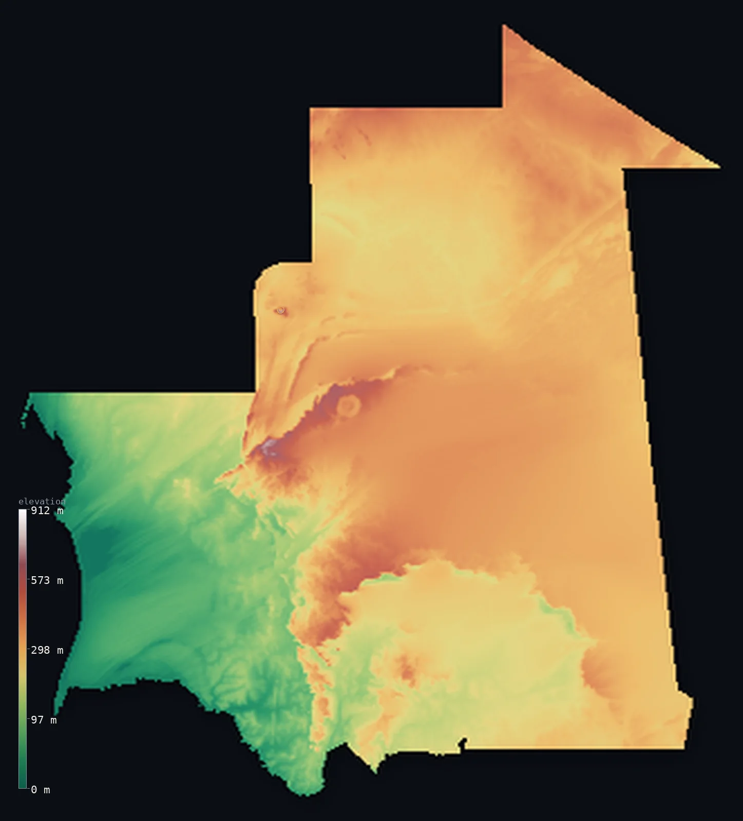
Mauritania’s highest point is Kediet ej Jill at 3,002 ft (915 m); its lowest is Sebkhet Te-n-Dghamcha at −16 ft (−5 m); the mean elevation is 853 ft (260 m).
Mauritania is a vast, largely Saharan country of northwest Africa — the largest country in the world lying entirely below 1,000 m. Most of it is desert plateau and plain: the sandstone Adrar and Tagant plateaus and the sand and rock between, with the iron massif of Kediet ej Jill in the far north the highest point, at just 3,002 ft (915 m). These modest plateaus are the bulk of the land, so half of Mauritania lies above about 950 ft — higher than the mean, which is pulled down by the low Atlantic coast and the salt-flat basins, one of which, the Sebkhet Te-n-Dghamcha, dips about 5 m below sea level.
- Highest point📚
- 3,002 ft915 m
- Mauritania's highest point is Kediet ej Jill at 3,002 ft (915 m), a massive iron-ore (magnetite) massif rising from the desert in the Tiris Zemmour region of the far north, near Zouérat. Despite its size Mauritania has no real mountains: Kediet ej Jill and the Adrar and Tagant plateaus are the only high ground; no part of the country reaches 1,000 m.
- Lowest point📚
- −16 ft−5 m
- Mauritania's lowest point is the Sebkhet Te-n-Dghamcha, a salt flat near the Atlantic coast north of Nouakchott that lies about 16 ft (5 m) below sea level — a rare below-sea depression in an otherwise desert country. Most of Mauritania is dry plateau and sand, but here, near the coast, the land dips just beneath the sea.
- Mean elevation⚙
- 853 ft260 m
- Computed from the GLO-30 model, Mauritania's mean elevation is 853 ft (260 m) — low, for the country is mostly desert plain and modest plateau, with no mountains. Yet half of Mauritania lies above about 951 ft (290 m), higher than the mean: the Saharan plateaus of the interior are the bulk of the land, while the low Atlantic coastal plain and the sebkha basins — one of them below sea level — pull the average down below the midpoint.
- Median elevation⚙
- 951 ft290 m
- Half of Mauritania lies above about 951 ft (290 m) — and, unusually, this midpoint sits above the mean, because the modest Saharan plateaus (the Adrar, the Tagant) make up most of the country, while a low minority — the Atlantic coastal plain and the sebkha basins, including a point below sea level — drags the average lower. Mauritania is low overall, but its low ground is concentrated near the coast.
- Elevation range📚
- 3,018 ft920 m
- From the Sebkhet Te-n-Dghamcha at about 5 m below sea level to Kediet ej Jill at 915 m, Mauritania's terrain spans only about 3,020 ft — a small range for so vast a country, because Mauritania has no mountains: no ground reaches 1,000 m, a land of desert plains, low plateaus, and a single iron massif.
- Official area📚
- 397,955 mi²1,030,700 km²
- Mauritania covers about 397,955 sq mi (1,030,700 sq km) — a vast, largely Saharan country of northwest Africa, of sand ergs and rocky regs broken by the sandstone Adrar and Tagant plateaus, the isolated iron massif of Kediet ej Jill in the far north, and a low Atlantic coastal plain (Nouakchott, Nouadhibou) in the west.
- Forest cover📚
- 1%
- About 1% of Mauritania is forested — a desert country of sand and rock, with vegetation only in the far south along the Senegal River, the country's one perennial watercourse, and scattered oases across the interior.
Highest and lowest points
The highest point of Mauritania at 915 m - Kediet ej Jill (Kediet Ijill), a massive iron-ore (magnetite) massif rising from the desert in the Tiris Zemmour region of the northwest, between Zouerat and Fderik. It is interior, near but not on the Western Sahara border. The magnetite is so concentrated that compasses fail on the mountain.
source ↗Mauritania's lowest point is the Sebkhet Te-n-Dghamcha, a coastal salt flat north of Nouakchott lying about 5 m below sea level — a rare below-sea depression in a desert land. Mauritania is vast and largely Saharan: the bulk of it is sand ergs and rocky regs, broken by the sandstone plateaus of the Adrar and the Tagant and, in the far north, the iron-rich massif of Kediet ej Jill, mined since the 11th century, from which ore rides to the coast on one of the longest trains in the world. In the north, too, lies the Guelb er Richat — the 'Eye of the Sahara,' a 40 km concentric ring of rock so striking it is used as a landmark from orbit. The low ground is in the west and south: the Atlantic coastal plain around Nouakchott and Nouadhibou, with the Banc d'Arguin, and the Senegal River valley in the far south, the country's only perennial river. Everywhere else depends on oases and groundwater — a low, dry land whose one below-sea point lies quietly by the coast.
source ↗Mauritania at a glance
Mauritania is the largest country in the world lying entirely below 1,000 m - its high point reaches only 915 m.
source ↗Its high point, Kediet ej Jill, is a massif so rich in iron ore that it has been mined since the 11th century and commercially worked since 1952.
source ↗Despite being mostly desert, Mauritania has a real below-sea-level point - the Sebkhet Te-n-Dghamcha salt flat at about −16 ft (−5 m).
source ↗The Guelb er Richat, or 'Eye of the Sahara', is a 40 km concentric ring of rock in the north so striking it is used as a landmark from orbit.
source ↗Iron ore from Kediet ej Jill rides to the coast on one of the longest trains in the world, up to about 3 km long.
source ↗The Senegal River in the far south is the country's only perennial river - everywhere else relies on oases and groundwater.
source ↗
Elevation profile of Mauritania
The largest share of land, 39%, falls in the 300–400 m band, and 99% of the territory lies below 500 m (1,640 ft).
- below 500 m (1,640 ft)99%
- 500–1,000 m1%
Highest peaks of Mauritania
| Peak | Elevation | Range | Note |
|---|---|---|---|
| Kediet ej Jill↗ | 3,002 ft915 m | Tiris Zemmour (northwest) | Highest point of Mauritania, an iron-ore massif rising abruptly from the desert near Zouerat. |
| Adrar Plateau (high ground)↗ | 1,640 ft500 m | Adrar Plateau (central) | The highest of the central sandstone plateaus, around the oasis towns of Atar and Chinguetti. |
| Tagant Plateau (high ground)↗ | 1,312 ft400 m | Tagant Plateau (central-south) | A sandstone plateau of the central-south, rising above the surrounding Sahel plains. |
Mauritania: the Saharan plains and plateaus, the isolated peaks, and the coast
The Saharan plains and plateaus
The bulk of the country — sand ergs and rocky regs, broken by southwest-facing scarps and the sandstone plateaus of the Adrar and the Tagant. The vast, dry, modestly high interior, holding the Guelb er Richat, the 'Eye of the Sahara.'
The isolated peaks
Mineral-rich massifs rising above the plateaus — the 'guelbs' and 'kedias,' chief among them Kediet ej Jill, an iron-ore massif in the far north and the country's highest point.
The coast and Senegal valley
The low Atlantic coastal plain in the west — Nouakchott, Nouadhibou, and the Banc d'Arguin, with the below-sea Sebkhet Te-n-Dghamcha — and, in the far south, the Senegal River valley, the country's only perennial river.
How to read this map
Color shows elevation; the raised relief shows real terrain. On this map Mauritania reads as a low, dry expanse — broad desert tone across the interior plateaus, the isolated rise of Kediet ej Jill and the other massifs in the north, and the low coastal plain in the west, dipping below the sea at the Sebkhet Te-n-Dghamcha.
Because the country is low and flat, the 3D exaggeration is what makes the desert plateaus and massifs stand out; the ×N relief slider controls how much. Tap anywhere to read that point's exact elevation.
City elevations in Mauritania
Mauritania's towns lie mostly on the coast and in the far south — Nouakchott, the capital, and the port of Nouadhibou on the Atlantic, with Kaédi and Kiffa toward the Senegal River — while the desert interior holds the iron-mining town of Zouérat near Kediet ej Jill and oasis centres like Atar on the Adrar.
| City | Population | Elevation |
|---|---|---|
| Nouakchottcapitalthe capital, on the Atlantic coastal plain ↗ | 1,184,530 | 20 ft6 m |
| Nouadhiboua port on the far northwest coast ↗ | 146,048 | 46 ft14 m |
| Kiffain the south ↗ | 62,051 | 404 ft123 m |
| Némain the far southeast ↗ | 60,000 | 869 ft265 m |
| Mbera | 58,985 | 889 ft271 m |
| Kaédiin the far south, on the Senegal River ↗ | 56,283 | 69 ft21 m |
| Zouératin the far north, an iron-mining town near Kediet ej Jill ↗ | 55,183 | 1,158 ft353 m |
| Sélibabyin the far south, toward the Senegal River ↗ | 32,653 | 200 ft61 m |
| Atarin the north, an oasis town on the Adrar Plateau ↗ | 31,133 | 738 ft225 m |
| Ayoun El Atrous | 28,174 | 758 ft231 m |
Elevation sampled at each city centre from the Copernicus GLO-30 model. Cities and population from GeoNames (CC-BY 4.0).
Mauritania in comparison
Mauritania's terrain rises 3,018 ft (920 m) from Sebkhet Te-n-Dghamcha, 16 ft (5 m) below sea level to Kediet ej Jill — about 10% of the height of Mount Everest, the world's highest point at 29,032 ft (8,849 m).
- Mali's mean elevation is 1,043 ft — 190 ft higher; its high point, Hombori Tondo, reaches 3,789 ft (1,155 m), 787 ft above. Mali elevation map →
- Senegal's mean elevation is 165 ft — 688 ft lower; its high point, Unnamed point near Nepen Diakha, reaches 2,126 ft (648 m), 876 ft below. Senegal elevation map →
Frequently asked questions
What is the highest point in Mauritania?
- Kediet ej Jill, 3,002 ft (915 m), an iron-ore massif rising from the desert in the far north near Zouérat - Mauritania is the largest country lying entirely below 1,000 m.
What is the average elevation of Mauritania?
- Computed from the Copernicus GLO-30 model, the area-weighted mean is 853 ft (260 m) - low, because Mauritania is mostly desert plain and modest plateau. Half the country lies above about 951 ft (290 m), higher than the mean, which the low coast pulls down.
What is the lowest point in Mauritania?
- The Sebkhet Te-n-Dghamcha, a coastal salt flat about 16 ft (5 m) below sea level - a rare below-sea point in an otherwise desert country.
Does Mauritania have mountains?
- Not really - its highest point, Kediet ej Jill, is an iron massif reaching only 915 m, and no part of the country tops 1,000 m. The Adrar and Tagant plateaus are its only other high ground.
What is the Eye of the Sahara?
- The Guelb er Richat, a 40 km concentric ring of rock in northern Mauritania - a geological formation so striking it is used as a landmark from orbit.
Is this a topographic, relief, contour, or elevation map of Mauritania?
- They describe the same thing - terrain height. This page renders Mauritania's actual elevation surface in interactive 3D and reports the statistics computed from it.
About this map
The terrain is rendered from the Copernicus GLO-30 digital elevation model (ESA), masked to the MRT-ADM0 boundary from geoBoundaries (gbOpen). Elevation statistics are computed directly from the model; peak names and researched facts are sourced and cited. See the methodology for the full pipeline.
Our area-weighted mean, computed from the Copernicus GLO-30 model, is 853 ft (260 m); the figure commonly cited elsewhere is 906 ft (276 m) (CIA World Factbook). Mauritania is a vast, low, Saharan country whose highest point, the iron massif of Kediet ej Jill, reaches only 915 m. Most of the country is desert plateau and plain: the sandstone Adrar and Tagant plateaus and the sand and rock of the interior. These modest uplands are the bulk of the land, so half of Mauritania lies above about 951 ft (290 m) — higher than the mean, which is dragged lower by the low ground concentrated near the Atlantic: the coastal plain and the salt-flat sebkhas, one of which, the Sebkhet Te-n-Dghamcha, dips about 5 m below sea level. So Mauritania is a low country whose modest high ground is the desert interior and whose lowest ground — even below the sea — lies by the coast.
Surveyed national figures: official area · forest cover · high point.
Rendered from Copernicus GLO-30 (ESA, 2021 release), boundaries from geoBoundaries. Generated 2026-06-24.
Bordering countries · 4
Mauritania shares a land border with these countries — open any one to compare its terrain and highest point.