Senegal Elevation Map — Topographic & 3D Terrain
Explore the terrain of Senegal in interactive 3D, built from Copernicus GLO-30 satellite elevation data — a low, flat country at the westernmost tip of Africa. Drag to rotate, scroll to zoom, and tap any point to read its elevation.
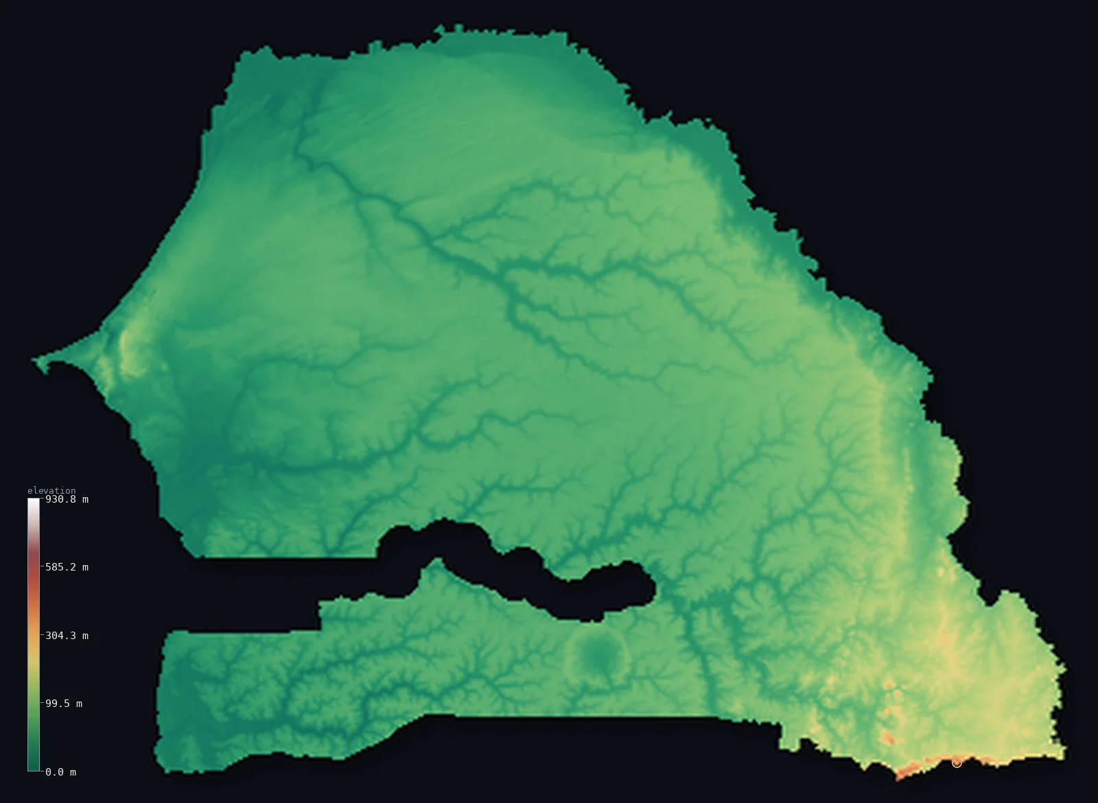
Senegal’s highest point is Unnamed point near Nepen Diakha at 2,126 ft (648 m); its lowest is Atlantic Ocean at 0 ft (0 m); the mean elevation is 165 ft (50.3 m).
Senegal is a low, flat country at the westernmost point of Africa. Almost all of it is low-lying plain — level sandy Sahelian and savanna country, much of it below 330 ft, sloping so gently that elevation barely changes across the whole land. The coast on the Atlantic is low and sandy, reaching Cape Verde (Cap-Vert) near Dakar, the westernmost point of the African mainland. Only in the far southeast, toward the Fouta Djallon highlands of Guinea, does the land rise at all — to modest foothills holding the country's highest point, an unnamed rise of about 2,126 ft (648 m) near Népen Diakha.
- Highest point📚
- 2,126 ft648 m
- Senegal's highest point is an unnamed hill of about 2,126 ft (648 m) in the far southeast, near Népen Diakha, on the approaches to the Fouta Djallon highlands of Guinea — the sole rise in an otherwise level land. The summit is right on the Guinea border; the highest ground fully within Senegal is a little lower, about 1,958 ft (597 m). Everywhere else, Senegal is low, level plain.
- Lowest point📚
- 0 ft0 m
- Senegal's lowest point is the Atlantic Ocean at sea level, along its low, sandy western coast — a shore of beaches, dunes, and lagoons that includes Cape Verde near Dakar, the westernmost point of mainland Africa.
- Mean elevation⚙
- 165 ft50.3 m
- Computed from the GLO-30 model, Senegal's mean elevation is 165 ft (50.3 m) — barely above sea level, and telling: Senegal is almost all low, flat plain, level Sahelian and savanna country, with only the far-southeastern hills lifting any of it appreciably above the coast.
- Median elevation⚙
- 149 ft45.4 m
- Half of Senegal lies below about 149 ft (45.4 m) — a figure that captures how low and flat the country is: level Sahelian and savanna plain runs from the coast inland at much the same modest height, with only the far-southeastern foothills rising clear of it.
- Elevation range📚
- 2,126 ft648 m
- Senegal's whole vertical span is only about 2,130 ft — sea level to a 648 m rise in the far southeast — and that lone corner aside, the country barely leaves the coastal plain: level, low Sahel and savanna from end to end.
- Above 50 m (164 ft)⚙
- 38%
- About 38% of Senegal rises above 50 m (164 ft) — the interior plains and the far-southeastern rise; most of the country, the low coast and the river lowlands, lies below even that modest height.
- Official area📚
- 75,955 mi²196,722 km²
- Senegal covers about 76,000 sq mi (196,722 sq km) — a low, flat West African country at the westernmost tip of the continent, of level Sahelian and savanna plains, with a sandy Atlantic coast and modest hills only in the far southeast.
- Forest cover📚
- 41.6%
- About 42% of Senegal is forested — mostly dry wooded savanna and scrub, thinning to near-desert Sahel in the north along the Senegal River, with denser woodland and gallery forest in the wetter south (the Casamance).
Highest and lowest points
Senegal's highest point is an unnamed hill of about 2,126 ft (648 m), in the far southeast near the village of Népen Diakha, close to the borders with Guinea and Mali. This corner of the country lies on the northern approaches to the Fouta Djallon — the great highland massif of neighbouring Guinea — and the modest foothills here are the only real relief in an otherwise flat land. The summit itself sits right on the Guinea border; the highest ground fully within Senegal is a little lower, about 1,958 ft (597 m). The 'summit' is a low, rounded rise, not a mountain; it simply happens to be the highest ground in a country that is, almost everywhere else, low and level plain. Senegal's character is not in its heights but in its flatness and its rivers.
source ↗Senegal's lowest point is the Atlantic Ocean at sea level, along a low, sandy western coast of beaches, dunes, and lagoons. At its western end lies the Cape Verde peninsula (Cap-Vert), on which sits Dakar — the westernmost point of the African mainland. Senegal is a flat country: from this coast the land rises only very gently inland across level Sahelian and savanna plains, drained by the Senegal River along the northern border and the Gambia and Casamance rivers in the south. Only in the far southeast does it rise into modest hills. The country all but surrounds The Gambia, which follows its river in a narrow enclave nearly cutting Senegal's south from its centre.
source ↗Unnamed point near Nepen Diakha is a border summit: its peak lies just outside the generalized Senegal boundary, so the highest fully in-territory land pixel in the model is 1,958 ft (597 m). The headline figure above is the surveyed elevation of the recognised national high point.
Senegal at a glance
Senegal has no mountains - its highest point is an unnamed ridge of about 648 m on the Guinea border in the far southeast.
source ↗Almost the whole country lies below 100 m; only the Cap-Vert peninsula and the southeast rise higher.
source ↗The Cap-Vert peninsula at Dakar is the westernmost point of mainland Africa.
source ↗The country of The Gambia reaches more than 320 km into Senegal along the Gambia River, nearly cutting it in two.
source ↗On the flat lower Senegal River, ocean tides can push saltwater nearly 200 km upstream in the dry season.
source ↗
Elevation profile of Senegal
The largest share of land, 62%, falls in the 0–50 m band, and >99% of the territory lies below 500 m (1,640 ft).
- 0–10 m (0–33 ft)9%
- 10–50 m (33–164 ft)53%
- above 50 m (164 ft)38%
Highest peaks of Senegal
| Peak | Elevation | Range | Note |
|---|---|---|---|
| Unnamed point near Nepen Diakha↗ | 2,126 ft648 m | Fouta Djallon foothills (southeast) | Highest point of Senegal, a ridge on the Guinea border in the far southeast. |
| Les Mamelles↗ | 344 ft105 m | Cap-Vert peninsula (Dakar) | Two small volcanic hills overlooking Dakar and the Atlantic - among the few rises in the flat west. |
Senegal: the coast and western plains, the Sahelian interior, and the Casamance
The coast and western plains
Senegal's Atlantic coast is low and sandy — beaches, dunes, and lagoons, reaching the Cape Verde peninsula (the westernmost point of mainland Africa) at Dakar. Behind it stretch low, level western plains, flat and dry, holding much of the population. The country's low, sandy seaward face.
The Sahelian and savanna interior
Most of Senegal is low, level plain — dry Sahelian grassland in the north along the Senegal River, and wooded savanna across the centre and east, flat and sandy throughout. The broad, gently sloping lowland that is nearly the whole country.
The Casamance and the southeastern hills
The far south — the Casamance, beyond The Gambia — is wetter and greener, of denser woodland and rice country, while the far southeast rises into modest foothills (the country's high point) on the approaches to Guinea's Fouta Djallon. The lusher and, in the southeast, the only higher corner of the country.
How to read this map
Color shows elevation; the raised relief shows real terrain. On this map Senegal reads as a flat, low country — a broad expanse of low, uniform tone covering nearly all of it, the level Sahelian and savanna plains, with the low sandy coast in the west (Cap-Vert reaching out at Dakar) and only the faintest rise in the far southeast, the foothills toward Guinea.
With so little relief, the 3D exaggeration is what makes the gentle differences visible; the ×N relief slider controls how much. Tap anywhere to read that point's exact elevation.
City elevations in Senegal
Senegal's cities cluster on the coast and along the rivers — Dakar, the capital, on the Cape Verde peninsula, Thiès inland nearby, Saint-Louis on the northern coast at the Senegal River mouth, and Ziguinchor in the southern Casamance. Most lie low, on or near the coast.
| City | Population | Elevation |
|---|---|---|
| Dakarcapitalthe capital, on the Cape Verde peninsula — the westernmost point of mainland Africa ↗ | 2,646,503 | 26 ft8 m |
| Toubain the centre of the country ↗ | 1,120,824 | 141 ft43 m |
| Thièsinland, east of Dakar ↗ | 317,763 | 240 ft73 m |
| Kaolackin the centre, on the Saloum River ↗ | 298,904 | 10 ft3 m |
| Saint-Louison the northern coast, at the Senegal River mouth ↗ | 254,171 | 13 ft4 m |
| Ziguinchorin the southern Casamance ↗ | 214,874 | 46 ft14 m |
| Tambacoundain the east ↗ | 149,071 | 98 ft30 m |
| Koldain the southern Casamance ↗ | 103,574 | 43 ft13 m |
| Richard-Tollin the north, on the Senegal River ↗ | 73,147 | 13 ft4 m |
| Kaffrinein the centre ↗ | 57,307 | 36 ft11 m |
Elevation sampled at each city centre from the Copernicus GLO-30 model. Cities and population from GeoNames (CC-BY 4.0).
Senegal in comparison
Senegal's terrain rises 2,126 ft (648 m) from sea level to Unnamed point near Nepen Diakha — about 7% of the height of Mount Everest, the world's highest point at 29,032 ft (8,849 m).
- Guinea's mean elevation is 1,447 ft — 1,282 ft higher; its high point, Mount Nimba (Mont Richard-Molard), reaches 5,748 ft (1,752 m), 3,622 ft above. Guinea elevation map →
- Mali's mean elevation is 1,043 ft — 878 ft higher; its high point, Hombori Tondo, reaches 3,789 ft (1,155 m), 1,663 ft above. Mali elevation map →
- Mauritania's mean elevation is 853 ft — 688 ft higher; its high point, Kediet ej Jill, reaches 3,002 ft (915 m), 876 ft above. Mauritania elevation map →
Frequently asked questions
What is the highest point in Senegal?
- An unnamed hill of about 2,126 ft (648 m) in the far southeast, near Népen Diakha, on the approaches to Guinea's Fouta Djallon highlands — a modest rise, as Senegal has no mountains.
What is the lowest point in Senegal?
- The Atlantic Ocean at sea level, along the low sandy coast — which at Cape Verde near Dakar reaches the westernmost point of mainland Africa.
What is the average elevation of Senegal?
- Computed from the Copernicus GLO-30 model, the area-weighted mean is 165 ft (50.3 m) — very low, because Senegal is almost entirely low, flat plain, with only modest hills in the far southeast.
Is Senegal flat?
- Yes — almost the whole country is low, level Sahelian and savanna plain, sloping very gently. The only real relief is modest foothills in the far southeast, rising toward Guinea's highlands; the highest point is only about 648 m.
What is the westernmost point of Africa?
- Cape Verde (Cap-Vert), the peninsula at Dakar in Senegal — the westernmost point of the African mainland, reaching into the Atlantic.
Is this a topographic, relief, contour, or elevation map of Senegal?
- They describe the same thing — terrain height. This page renders the country's actual elevation surface in interactive 3D and reports the statistics computed from it.
About this map
The terrain is rendered from the Copernicus GLO-30 digital elevation model (ESA), masked to the SEN-ADM0 boundary from geoBoundaries (gbOpen). Elevation statistics are computed directly from the model; peak names and researched facts are sourced and cited. See the methodology for the full pipeline.
Our area-weighted mean, computed from the Copernicus GLO-30 model, is 165 ft (50.3 m); the figure commonly cited elsewhere is 226 ft (69 m) (CIA World Factbook). Senegal is a flat country lying in the low Senegal-Mauritanian sedimentary basin - sandy Sahel plains and river valleys across almost all of it, rising only in the far southeast - so its mean elevation is very low; the page reports the area-weighted figure computed from the Copernicus GLO-30 model.
Surveyed national figures: official area · forest cover · high point.
Rendered from Copernicus GLO-30 (ESA, 2021 release), boundaries from geoBoundaries. Generated 2026-06-26.
Bordering countries · 5
Senegal shares a land border with these countries — open any one to compare its terrain and highest point.