Guinea-Bissau Elevation Map
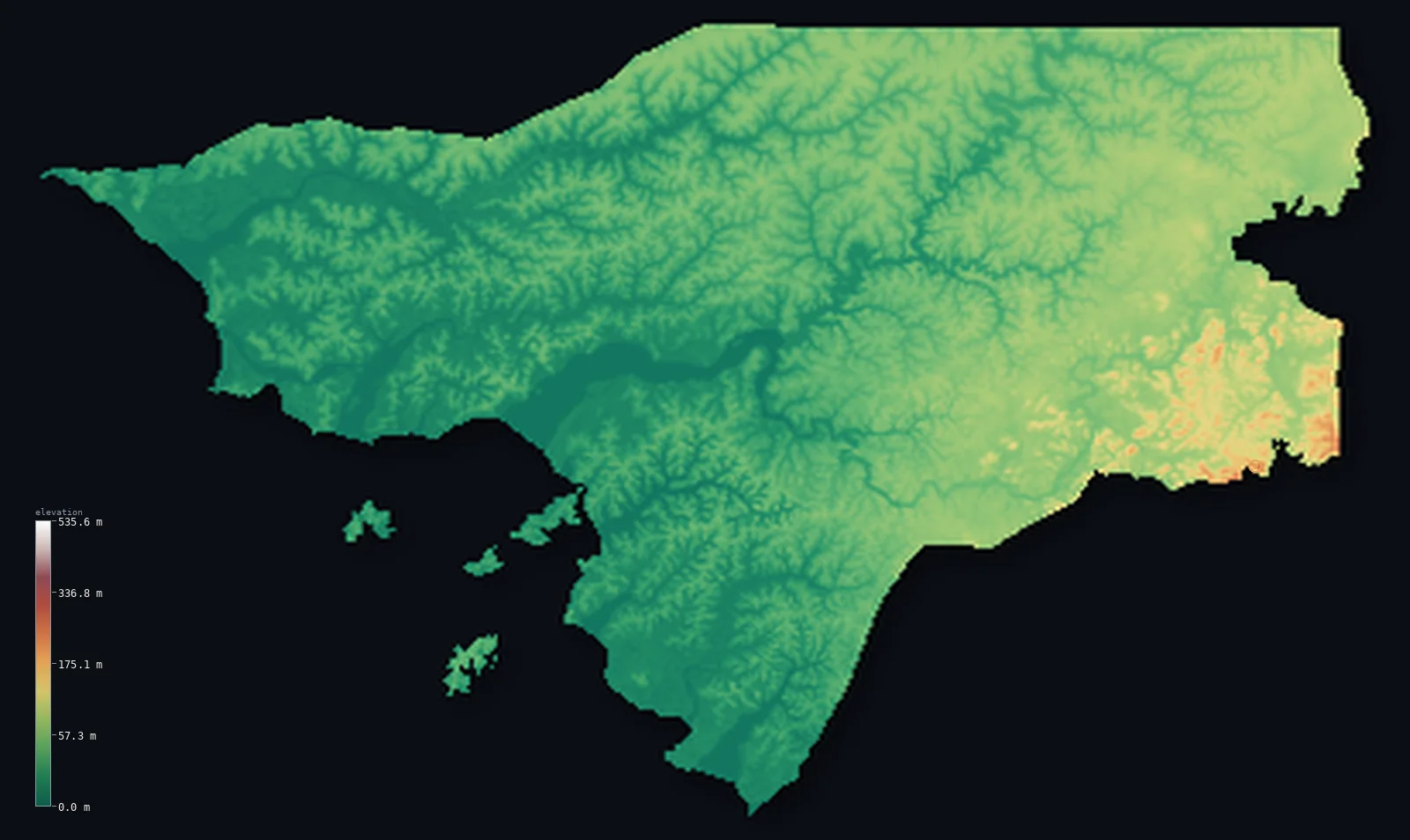
Guinea-Bissau’s highest point is Monte Torin at 860 ft (262 m); its lowest is Atlantic Ocean at 0 ft (0 m); the mean elevation is 114 ft (34.8 m).
- Highest point📚
- 860 ft262 m
- An unnamed ~300 m rise on the southeastern plateau, near the Guinea border.
- Lowest point📚
- 0 ft0 m
- Sea level along the deeply indented Atlantic coast.
- Mean elevation⚙
- 114 ft34.8 m
- Computed from the GLO-30 surface model across the whole country.
- Median elevation⚙
- 95 ft28.9 m
- Half of Guinea-Bissau lies below this height.
- Elevation range📚
- 860 ft262 m
- From the Atlantic to about 300 m - a very small total relief.
- Above 50 m (164 ft)⚙
- 29%
- The Bafata and Gabu plateaus of the interior.
- Official area📚
- 13,948 mi²36,125 km²
- A small, low, estuary-laced country with a large offshore archipelago.
- Forest cover📚
- 70.4%
- About 70% is forest and woodland, with extensive coastal mangroves.
Highest and lowest points
The highest point of Guinea-Bissau is Monte Torin (also called Dongol Ronde or Mt Ronde), about 262 m, a low hill in the Gabu region near the southern border with Guinea. DISCLOSURE: Guinea-Bissau has never been surveyed precisely enough to settle its high point definitively - there are two candidate hills within the roughly 16 m error of satellite elevation data, and figures of 262 m and 266 m are both cited. This is among the lowest and least-certain national high points in the world.
source ↗Guinea-Bissau at a glance
Guinea-Bissau is so flat that its highest point is an unnamed rise of only about 300 m - and the country has never been surveyed precisely enough to be sure which hill is actually the highest.
source ↗The land is so low that tides push seawater up to 100 km inland, and about 10% of the coastland is underwater at high tide.
source ↗Off the coast, the Bijagos Archipelago - about 88 low islands - is a UNESCO biosphere reserve, home to saltwater hippos and nesting sea turtles.
source ↗To fight the salt left by tidal flooding, farmers have built many 'anti-salt' dams along the coast to protect their rice paddies.
source ↗The country's highest ground sits right on the Guinea border, where its plateau begins to climb toward the Fouta Djallon - the great highland just across the frontier.
source ↗Around 70% of Guinea-Bissau is forest and woodland, including some of West Africa's most extensive coastal mangroves.
source ↗
Elevation profile of Guinea-Bissau
The largest share of land, 38%, falls in the 0–20 m band, and 100% of the territory lies below 500 m (1,640 ft).
- 0–10 m (0–33 ft)26%
- 10–50 m (33–164 ft)44%
- above 50 m (164 ft)29%
Highest peaks of Guinea-Bissau
| Peak | Elevation | Range | Note |
|---|---|---|---|
| Unnamed elevation (Gabu Plateau / Boe)↗ | 984 ft300 m | Gabu Plateau (southeast, Guinea border) | The country's highest ground - an unnamed, unsurveyed rise of about 300 m on the southeastern plateau, on the Guinea border. |
Terrain regions of Guinea-Bissau
Guinea-Bissau is so flat that its highest point is an unnamed rise of only about 300 m - and the country has never been surveyed precisely enough to be sure which hill is actually the highest. ↗
The coastal plain and estuaries
↗A low, flat Atlantic coastal plain laced with mangroves, tidal flats and drowned river valleys (rias) - tidal water reaches up to 100 km inland, and about a tenth of the coastland floods at high tide.
The Bijagos Archipelago
↗A cluster of some 88 low islands (about 18 major) on the shallow continental shelf off the coast, a UNESCO biosphere reserve of mangroves, palm groves, mudflats and rich wildlife.
The interior plateaus
↗Gently rising inland country - the Bafata Plateau in the centre and the Gabu (Boe) Plateau in the southeast, reaching about 180-300 m as the land approaches the Fouta Djallon highlands of Guinea.
The coast, estuaries and islands
the coastal lowlands and islandsMost of Guinea-Bissau is a low, flat coastal plain, deeply cut by the wide estuaries of the Cacheu, Mansoa, Geba, Corubal and other rivers, fringed with mangroves and tidal flats. Tidal water penetrates up to 100 km inland, and about 10% of the coastland is submerged at high tide. Off the coast lies the Bijagos Archipelago - some 88 low islands on the continental shelf.
The interior plateaus
the interiorInland, the land rises gently to the Bafata Plateau in the centre and the Gabu (Boe) Plateau in the southeast. Even here the country stays low - the highest ground, an unnamed and unsurveyed rise of about 300 m near the Guinea border, marks the gentle approach to the Fouta Djallon highlands beyond. The whole country has a total relief of only about 300 m.
City elevations in Guinea-Bissau
| City | Population | Elevation |
|---|---|---|
| BissaucapitalBissau, the capital, sits on the Geba River estuary on the central coast, on low, tidal land near sea level. ↗ | 439,704 | 49 ft15 m |
| Gabú | 49,371 | 203 ft62 m |
| Bafatá | 33,502 | 46 ft14 m |
| Xitole | 19,424 | 102 ft31 m |
| Canchungo | 13,652 | 7 ft2 m |
| Bissorã | 12,688 | 56 ft17 m |
| Madina do Boé | 11,750 | 230 ft70 m |
| Bolama | 10,769 | 62 ft19 m |
| Bula | 10,213 | 72 ft22 m |
| Farim | 10,207 | 10 ft3 m |
Elevation sampled at each city centre from the Copernicus GLO-30 model. Cities and population from GeoNames (CC-BY 4.0).
Guinea-Bissau in comparison
Guinea-Bissau's terrain rises 860 ft (262 m) from sea level to Monte Torin — about 3% of the height of Mount Everest, the world's highest point at 29,032 ft (8,849 m).
- Guinea's mean elevation is 1,447 ft — 1,333 ft higher; its high point, Mount Nimba (Mont Richard-Molard), reaches 5,748 ft (1,752 m), 4,888 ft above. Guinea elevation map →
- Senegal's mean elevation is 165 ft — 51 ft higher; its high point, Unnamed point near Nepen Diakha, reaches 2,126 ft (648 m), 1,266 ft above. Senegal elevation map →
- The Gambia's mean elevation is 69 ft — 45 ft lower; its high point, Unnamed elevation (eastern Gambia), reaches 174 ft (53 m), 686 ft below. The Gambia elevation map →
Frequently asked questions
What is the highest point in Guinea-Bissau?
- An unnamed location of about 860 ft (262 m) on the southeastern plateau, near the Guinea border - the country is so flat that its high point is modest and unsurveyed.
Why doesn't Guinea-Bissau's highest point have a name?
- The country has never been surveyed precisely enough to settle which low hill is highest; the leading candidates are unnamed rises of about 300 m sitting right on the Guinea border.
What is the average elevation of Guinea-Bissau?
- Computed from the Copernicus GLO-30 model, the area-weighted mean is 114 ft (34.8 m). Guinea-Bissau is one of the flattest countries in the region.
What is the lowest point in Guinea-Bissau?
- Sea level, along its deeply indented Atlantic coast in the west.
What is the Bijagos Archipelago?
- A group of about 88 low islands off the coast, on the continental shelf - a UNESCO biosphere reserve known for mangroves, palm groves and unusual wildlife.
Is Guinea-Bissau flat?
- Very - it is mostly low coastal plain and gently rising plateaus, with a total relief of only about 300 m and a mean elevation around 70 m.
Is this a topographic, relief, contour, or elevation map of Guinea-Bissau?
- They describe the same thing - terrain height. This page renders Guinea-Bissau's actual elevation surface in interactive 3D (a relief or topographic view) and reports the elevation statistics computed from it; a contour map shows the same data as lines of equal height.
About this map
The terrain is rendered from the Copernicus GLO-30 digital elevation model (ESA), masked to the GNB-ADM0 boundary from geoBoundaries (gbOpen). Elevation statistics are computed directly from the model; peak names and researched facts are sourced and cited. See the methodology for the full pipeline.
This map renders 34,436 km² across 6 landmasses of Guinea-Bissau. 28 smaller outlying parts — 835 km² in total — lie beyond the area shown here. Area statistics above count the full territory.
Our area-weighted mean, computed from the Copernicus GLO-30 model, is 114 ft (34.8 m); the figure commonly cited elsewhere is 230 ft (70 m) (CIA World Factbook). Guinea-Bissau is one of the flattest countries in West Africa - a low coastal plain and gently rising interior plateaus that barely reach 300 m - so the mean elevation is very low; the page reports the area-weighted figure computed from the Copernicus GLO-30 model.
Surveyed national figures: official area · forest cover · high point.
Rendered from Copernicus GLO-30 (ESA, 2021 release), boundaries from geoBoundaries. Generated 2026-07-18.
Bordering countries · 2
Guinea-Bissau shares a land border with these countries — open any one to compare its terrain and highest point.