The Gambia Elevation Map
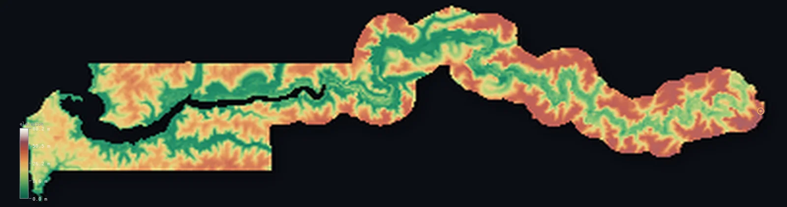
The Gambia’s highest point is Unnamed elevation (eastern Gambia) at 174 ft (53 m); its lowest is Atlantic Ocean at 0 ft (0 m); the mean elevation is 69 ft (21.1 m).
- Highest point📚
- 174 ft53 m
- An unnamed low rise of about 53 m near the eastern border.
- Lowest point📚
- 0 ft0 m
- Sea level at the Atlantic coast and the Gambia River mouth.
- Mean elevation⚙
- 69 ft21.1 m
- Computed from the GLO-30 surface model across the whole country.
- Median elevation⚙
- 64 ft19.4 m
- Half of The Gambia lies below this height.
- Elevation range📚
- 174 ft53 m
- From sea level to only about 53 m - one of the smallest elevation ranges of any country.
- Above 50 m (164 ft)⚙
- 1%
- Low hills and terraces flanking the Gambia River floodplain.
- Official area📚
- 4,363 mi²11,300 km²
- A tiny, narrow country following the lower Gambia River, almost enclosed by Senegal.
- Forest cover📚
- 43.9%
- Roughly two-fifths is woodland, with mangroves near the coast and savanna inland.
Highest and lowest points
The Gambia is so flat that its highest point is an unnamed low rise of about 53 m (sometimes called 'Red Rock'), in the eastern Upper River area near the Senegal border. The country is one of the flattest on Earth, and the exact high point is uncertain - independent satellite surveys have found several unnamed candidates between roughly 53 and 65 m.
source ↗Unnamed elevation (eastern Gambia)'s surveyed summit sits just outside the generalized The Gambia boundary, so the highest fully in-territory land pixel in the model is 199 ft (60.8 m). The headline figure above is the surveyed elevation of the recognised national high point.
The Gambia at a glance
The Gambia is one of the flattest countries on Earth - its highest point is an unnamed rise of only about 53 m, and its mean elevation is just 34 m.
source ↗It is the smallest country on mainland Africa, a narrow ribbon following the Gambia River and almost entirely surrounded by Senegal.
source ↗Legend says the borders were set by the range of British naval cannon fired from the river - but in reality they were carefully surveyed, mostly running about 10 km from each bank.
source ↗The Gambia is so flat and unsurveyed that its exact highest point is still uncertain - satellite data shows several unnamed candidates between about 53 and 65 m.
source ↗The Gambia River is tidal and salty far inland - seawater pushes up to about 250 km upstream in the dry season.
source ↗The whole country is barely above the sea, and large parts of the river 'flats' flood completely during the wet season.
source ↗
Elevation profile of The Gambia
The largest share of land, 21%, falls in the 0–5 m band, and 100% of the territory lies below 500 m (1,640 ft).
- 0–10 m (0–33 ft)32%
- 10–50 m (33–164 ft)67%
- above 50 m (164 ft)1%
Highest peaks of The Gambia
| Peak | Elevation | Range | Note |
|---|---|---|---|
| Unnamed elevation (eastern Gambia)↗ | 174 ft53 m | low hills flanking the Gambia River | The country's highest point - an unnamed low rise of about 53 m near the eastern Senegal border; The Gambia has no true mountains. |
Terrain regions of The Gambia
The Gambia is one of the flattest countries on Earth - its highest point is an unnamed rise of only about 53 m, and its mean elevation is just 34 m. ↗
The Atlantic coast and river mouth
↗The western end on the Atlantic - sandy beaches (the 'Smile Coast'), the peninsula holding Banjul and Serekunda, and the wide tidal mouth of the Gambia River fringed with mangroves.
The Gambia River floodplain
↗The heart of the country - the broad, flat valley of the Gambia River, tidal and salty far inland, lined by mangroves near the coast and by 'flats' that flood in the wet season.
The inland savanna and low hills
↗Upriver to the east, beyond the mangroves, the land becomes West Sudanian savanna with low hills and terraces rising only to about 53 m - the country's highest ground - near the Senegal border.
The Gambia River floodplain
the river valley (most of the country)The Gambia is essentially the lower valley of one river. A narrow strip of land - less than 48 km wide and about 470 km long - follows the Gambia River inland from the Atlantic, almost entirely enclosed by Senegal. The river is tidal and salty far upstream, lined by mangrove swamps for the first ~145 km and by seasonally flooded 'flats' behind them. The whole floodplain is flat and barely above sea level.
The savanna and low hills
the inland marginsAway from the river, the land rises into gently undulating West Sudanian savanna, with low hills, sandy terraces and occasional red ironstone (laterite) outcrops. Even the highest ground - an unnamed rise of about 53 m near the eastern border - is little more than a swell in the plain; The Gambia is among the flattest countries on Earth.
The Atlantic coast
the coastal stripAt its western end The Gambia meets the Atlantic along about 80 km of sandy 'Smile Coast', with the Banjul-Serekunda peninsula at the river mouth. Mangroves, dunes and lagoons line the shore, and the land here sits right at sea level.
City elevations in The Gambia
| City | Population | Elevation |
|---|---|---|
| SerekundaSerekunda, the largest urban area, lies just inland on the low Atlantic coastal peninsula near Banjul. ↗ | 340,000 | 39 ft12 m |
| BanjulcapitalBanjul, the capital, sits at sea level on St Mary's Island at the very mouth of the Gambia River, where it meets the Atlantic. ↗ | 37,274 | 13 ft4 m |
| Nema Kunku | 34,390 | 46 ft14 m |
| Farafenni | 32,883 | 43 ft13 m |
| Gunjur | 22,741 | 62 ft19 m |
| Farato | 15,017 | 82 ft25 m |
| Karang Poste | 14,624 | 131 ft40 m |
| Gambissar | 13,371 | 69 ft21 m |
| Bansang | 9,528 | 3 ft1 m |
| Sinchu Balla | 8,008 | 82 ft25 m |
Elevation sampled at each city centre from the Copernicus GLO-30 model. Cities and population from GeoNames (CC-BY 4.0).
The Gambia in comparison
The Gambia's terrain rises 174 ft (53 m) from sea level to Unnamed elevation (eastern Gambia) — about 1% of the height of Mount Everest, the world's highest point at 29,032 ft (8,849 m).
- Senegal's mean elevation is 165 ft — 96 ft higher; its high point, Unnamed point near Nepen Diakha, reaches 2,126 ft (648 m), 1,952 ft above. Senegal elevation map →
- Guinea-Bissau's mean elevation is 114 ft — 45 ft higher; its high point, Monte Torin, reaches 860 ft (262 m), 686 ft above. Guinea-Bissau elevation map →
- Guinea's mean elevation is 1,447 ft — 1,378 ft higher; its high point, Mount Nimba (Mont Richard-Molard), reaches 5,748 ft (1,752 m), 5,574 ft above. Guinea elevation map →
Frequently asked questions
What is the highest point in The Gambia?
- An unnamed low rise of about 174 ft (53 m) near the eastern border - the country has no true mountains and is one of the flattest on Earth.
What is the average elevation of The Gambia?
- Computed from the Copernicus GLO-30 model, the area-weighted mean is 69 ft (21.1 m). The country is a flat river floodplain, so the mean is very low.
What is the lowest point in The Gambia?
- Sea level, at the Atlantic coast and the mouth of the Gambia River.
Why is The Gambia so flat?
- Because it is essentially the floodplain of the Gambia River - a strip of low, sediment-filled valley in a stable basin, rising only to about 53 m at most.
Why is The Gambia such a strange shape?
- It follows the lower Gambia River as a narrow strip, with borders surveyed roughly 10 km from each bank, leaving it almost entirely enclosed by Senegal.
Does The Gambia have a coastline?
- Yes - a short Atlantic coast of about 80 km at its western end, where the Gambia River meets the sea near Banjul.
Is this a topographic, relief, contour, or elevation map of The Gambia?
- They describe the same thing - terrain height. This page renders The Gambia's actual elevation surface in interactive 3D (a relief or topographic view) and reports the elevation statistics computed from it; a contour map shows the same data as lines of equal height.
About this map
The terrain is rendered from the Copernicus GLO-30 digital elevation model (ESA), masked to the GMB-ADM0 boundary from geoBoundaries (gbOpen). Elevation statistics are computed directly from the model; peak names and researched facts are sourced and cited. See the methodology for the full pipeline.
Our area-weighted mean, computed from the Copernicus GLO-30 model, is 69 ft (21.1 m); the figure commonly cited elsewhere is 112 ft (34 m) (CIA World Factbook). The Gambia is a narrow, very flat strip of the Gambia River floodplain, rising only to about 53 m, so its mean elevation is very low; the page reports the area-weighted figure computed from the Copernicus GLO-30 model.
Surveyed national figures: official area · forest cover · high point.
Rendered from Copernicus GLO-30 (ESA, 2021 release), boundaries from geoBoundaries. Generated 2026-06-23.
Bordering countries · 1
The Gambia shares a land border with these countries — open any one to compare its terrain and highest point.