Guinea Elevation Map — Topographic & 3D Terrain
Explore the terrain of Guinea in interactive 3D, built from Copernicus GLO-30 satellite elevation data — a hilly, well-watered West African country whose Fouta Djallon highlands are the water tower of the region. Drag to rotate, scroll to zoom, and tap any point to read its elevation.
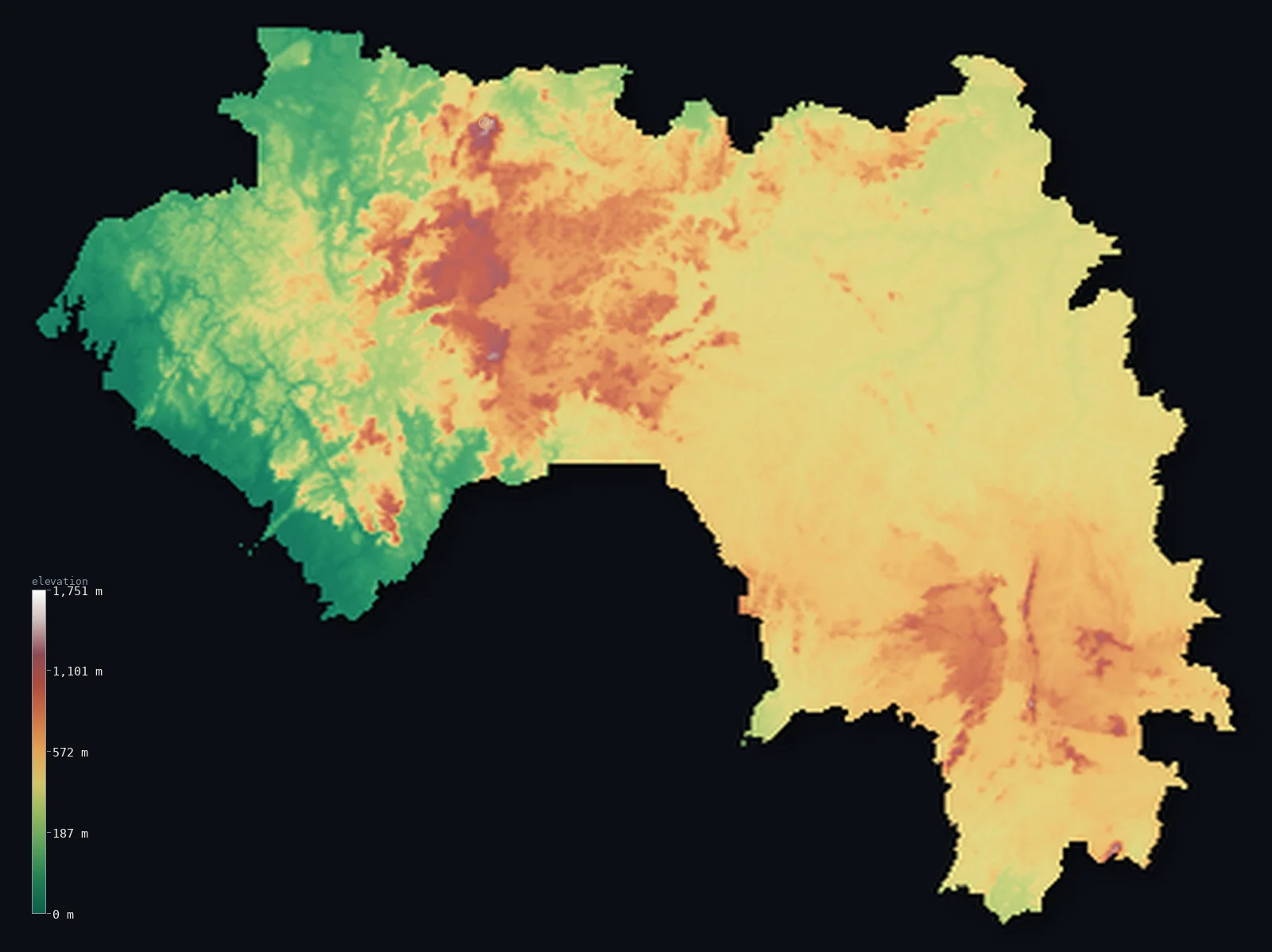
Guinea’s highest point is Mount Nimba (Mont Richard-Molard) at 5,748 ft (1,752 m); its lowest is Atlantic Ocean at 0 ft (0 m); the mean elevation is 1,447 ft (441 m).
Guinea is a hilly, well-watered country on the West African coast — and the source of the region's great rivers. Behind a low, wet coastal plain on the Atlantic rises the Fouta Djallon, a broad highland massif of sandstone plateaus and deep valleys that dominates the country's centre and gives it the name 'water tower of West Africa': the Niger, the Senegal, and the Gambia rivers all rise here. Beyond it, savanna plains stretch northeast toward the upper Niger, and forested hills rise in the southeast, climbing to the country's highest point at Mont Nimba, 5,748 ft (1,752 m), where Guinea meets Côte d'Ivoire and Liberia.
- Highest point📚
- 5,748 ft1,752 m
- Guinea's highest point is Mont Nimba at 5,748 ft (1,752 m), in the far southeast where the borders of Guinea, Côte d'Ivoire, and Liberia meet — the summit of a forested range shared between the three countries, famous for its unique wildlife. The peak lies essentially on Guinea's border; the highest ground within the country reaches almost exactly the same height. Nimba is higher than the Fouta Djallon highlands to the northwest, though those are the more extensive — and more important — high country.
- Lowest point📚
- 0 ft0 m
- Guinea's lowest point is the Atlantic Ocean at sea level, along the coast in the west — a low, wet, tidal shore of mangroves, estuaries, and rice plains, backed by the rise to the interior highlands.
- Mean elevation⚙
- 1,447 ft441 m
- Computed from the GLO-30 model, Guinea's mean elevation is 1,447 ft (441 m) — genuinely upland for the region, the mark of a hilly, well-watered country: the broad Fouta Djallon massif lifts much of the interior, with the western coastal plain and the northeastern savanna the lower ground and the southeastern hills higher still.
- Median elevation⚙
- 1,417 ft432 m
- Half of Guinea lies above about 1,417 ft (432 m) — a high median for West Africa, and a sign of how much of the country is upland: the Fouta Djallon and the interior hills cover most of it, leaving the coastal plain and the northeastern lowlands as the exceptions.
- Elevation range📚
- 5,748 ft1,752 m
- Guinea's terrain climbs about 5,750 ft in all, from the Atlantic to Mont Nimba's 1,752 m at the southeastern tripoint — but the country's real relief is broader than that single summit: the Fouta Djallon lifts the whole centre into sandstone plateaus and deep valleys, between the low coast and the savanna.
- Above 1,000 m (3,281 ft)⚙
- 1%
- About 1% of Guinea rises above 1,000 m (3,281 ft) — the higher Fouta Djallon plateaus and the southeastern hills around Mont Nimba. Broaden that to 500 m and 34% of the country clears it — most of the Fouta Djallon and the interior; the coastal plain and the northeastern savanna lie lower.
- Official area📚
- 94,926 mi²245,857 km²
- Guinea covers about 94,900 sq mi (245,857 sq km) — a West African country on the Atlantic, hilly and well-watered, dominated by the Fouta Djallon highlands (the source of the Niger, Senegal, and Gambia rivers), with a wet coastal plain, northeastern savanna, and forested southeastern hills rising to Mont Nimba.
- Forest cover📚
- 25.9%
- About 26% of Guinea is forested — tropical forest and mangroves along the wet coast, wooded savanna and gallery forest across the Fouta Djallon and the interior, and denser rainforest in the southeastern hills toward the Nimba range.
Highest and lowest points
Guinea's highest point is Mont Nimba, 5,748 ft (1,752 m), in the far southeast at the meeting point of Guinea, Côte d'Ivoire, and Liberia. It is the summit of the Nimba Range — a forested massif shared between the three countries, a UNESCO World Heritage Site famous for endemic species found nowhere else, including a viviparous toad. The summit lies right at the tripoint on Guinea's border, and the highest ground within Guinea reaches essentially the same height. Higher than the Fouta Djallon to the northwest, Mont Nimba is nonetheless the lesser of Guinea's two great uplands in importance: it is the Fouta Djallon, though lower, that is the true heart of the country and the source of West Africa's rivers. Nimba is the loftier summit; the Fouta Djallon is the greater highland.
source ↗Guinea's lowest point is the Atlantic Ocean at sea level, along a low, wet coast of mangroves, tidal estuaries, and rice plains — one of the wetter coasts in West Africa. But Guinea's defining feature is the high ground behind it: the Fouta Djallon, a broad massif of sandstone plateaus and deep, steep valleys rising across the centre of the country. Its importance is out of all proportion to its modest height, for it is the 'water tower of West Africa': three of the region's greatest rivers — the Niger, which curves off across the Sahel; the Senegal, which flows north to the desert's edge; and the Gambia — all rise in these highlands and flow out across neighbouring countries. From the Fouta Djallon the land falls to the coast in the west and the savanna in the northeast.
source ↗Mount Nimba (Mont Richard-Molard) is a border summit: its peak lies just outside the generalized Guinea boundary, so the highest fully in-territory land pixel in the model is 5,745 ft (1,751 m). The headline figure above is the surveyed elevation of the recognised national high point.
Guinea at a glance
Mount Nimba (1,752 m), Guinea's highest point, sits on the Cote d'Ivoire border and is the high point of both countries, just a few kilometres from the Liberian tripoint.
source ↗Guinea is called the 'water tower of West Africa' - over half the region's major rivers, including the Niger, Senegal and Gambia, rise in the Fouta Djallon or the Guinea Highlands.
source ↗The Fouta Djallon plateau rises in a series of abrupt fault scarps straight from the coastal plain, forming a deeply dissected highland the size of a small country.
source ↗The Mount Nimba reserve is so biologically rich - with viviparous toads, tool-using chimpanzees and many endemic species - that it is a UNESCO World Heritage Site shared by Guinea and Cote d'Ivoire.
source ↗Tides along Guinea's coast reach 4-5 m, pushing brackish water far up the estuaries and drowning former hills into offshore islands.
source ↗The Nimba mountains are rich in high-grade iron ore, making the same range that holds Guinea's summit a focus of major mining interest.
source ↗
Elevation profile of Guinea
The largest share of land, 42%, falls in the 400–600 m band, and 66% of the territory lies below 500 m (1,640 ft).
- below 500 m (1,640 ft)66%
- 500–1,000 m32%
- 1,000–2,000 m1%
Highest peaks of Guinea
| Peak | Elevation | Range | Note |
|---|---|---|---|
| Mount Nimba (Mont Richard-Molard)↗ | 5,748 ft1,752 m | Nimba Range (Cote d'Ivoire border) | Highest point of Guinea, on the Cote d'Ivoire border, the high point of the Nimba Range near the Liberian tripoint. |
| Grand Rochers↗ | 5,558 ft1,694 m | Nimba Range (Guinea) | A high peak of the Nimba Range on the Guinean side, near Mount Nimba. |
| Mont Sempere↗ | 5,518 ft1,682 m | Nimba Range (Guinea) | A peak of the Nimba Range within Guinea, part of the Mount Nimba massif. |
| Mont To↗ | 5,495 ft1,675 m | Nimba Range (Guinea) | A peak of the Nimba Range on the Guinean side of the massif. |
| Tamgue↗ | 5,046 ft1,538 m | Fouta Djallon (central) | The high point of the Fouta Djallon plateau, the central highland 'water tower' of West Africa. |
Guinea: the coastal plain, the Fouta Djallon, and the interior savanna and forest
The coastal plain (Lower Guinea)
Along the Atlantic runs a low, wet coastal plain — Lower Guinea — of mangroves, tidal estuaries, and rice-growing flats, one of the wetter coasts in the region, holding the capital, Conakry. Low and humid, it is the country's seaward edge below the highlands.
The Fouta Djallon (Middle Guinea)
The heart of the country is the Fouta Djallon — Middle Guinea — a broad highland massif of sandstone plateaus, tablelands, and deep, steep-sided valleys. The 'water tower of West Africa,' source of the Niger, Senegal, and Gambia, it is Guinea's defining upland, cool and green above the lowlands.
The northeastern savanna and southeastern hills (Upper and Forest Guinea)
Northeast of the Fouta Djallon the land falls to savanna plains — Upper Guinea — toward the upper Niger, while the far southeast rises again into the forested hills of the Guinea Highlands (Forest Guinea), holding Mont Nimba, the high point, at the Ivorian and Liberian border. Lower savanna and higher forest bracketing the central massif.
How to read this map
Color shows elevation; the raised relief shows real terrain. On this map Guinea reads as a highland country behind a low coast — a low green coastal plain in the west, rising sharply to the broad browns of the Fouta Djallon massif across the centre, easing to the savanna lowlands of the northeast, and rising again to the forested hills of the southeast at Mont Nimba on the tripoint.
The 3D relief is the actual GLO-30 elevation data, exaggerated vertically so the coast, the central highlands, and the southeastern hills all show; the ×N relief slider controls how much. Tap anywhere to read that point's exact elevation.
City elevations in Guinea
Guinea's cities range from the coast to the interior — Conakry, the capital, on its Atlantic peninsula, Kankan on the upper Niger in the northeast, Kindia and Labé in and around the Fouta Djallon, and Nzérékoré in the forested southeast. Coast, highland, and interior each hold major towns.
| City | Population | Elevation |
|---|---|---|
| Conakrycapitalthe capital, on an Atlantic peninsula on the coast ↗ | 1,928,389 | 39 ft12 m |
| Nzérékoréin the forested southeast, near the Nimba range ↗ | 226,426 | 1,588 ft484 m |
| Kankanon the upper Niger, in the northeastern savanna ↗ | 221,428 | 1,240 ft378 m |
| Kindiaat the western edge of the Fouta Djallon ↗ | 161,024 | 1,362 ft415 m |
| Siguirion the upper Niger in the northeast ↗ | 148,018 | 1,198 ft365 m |
| Kissidougouin the forested south ↗ | 116,019 | 1,726 ft526 m |
| Kamsara northwestern coastal bauxite port ↗ | 113,350 | 10 ft3 m |
| Labéhigh in the Fouta Djallon ↗ | 107,571 | 3,360 ft1,024 m |
| Gueckedouin the forested southeast ↗ | 79,140 | 1,391 ft424 m |
| Mamouin the Fouta Djallon, the gateway to the highlands ↗ | 79,109 | 2,369 ft722 m |
Elevation sampled at each city centre from the Copernicus GLO-30 model. Cities and population from GeoNames (CC-BY 4.0).
Guinea in comparison
Guinea's terrain rises 5,748 ft (1,752 m) from sea level to Mount Nimba (Mont Richard-Molard) — about 20% of the height of Mount Everest, the world's highest point at 29,032 ft (8,849 m).
- Côte d'Ivoire's mean elevation is 853 ft — 594 ft lower; its high point, Mont Nimba (Mount Richard-Molard), reaches 5,748 ft (1,752 m), 0 ft above. Côte d'Ivoire elevation map →
- Sierra Leone's mean elevation is 646 ft — 801 ft lower; its high point, Loma Mansa (Bintumani), reaches 6,391 ft (1,948 m), 643 ft above. Sierra Leone elevation map →
- Mali's mean elevation is 1,043 ft — 404 ft lower; its high point, Hombori Tondo, reaches 3,789 ft (1,155 m), 1,959 ft below. Mali elevation map →
- Senegal's mean elevation is 165 ft — 1,282 ft lower; its high point, Unnamed point near Nepen Diakha, reaches 2,126 ft (648 m), 3,622 ft below. Senegal elevation map →
Frequently asked questions
What is the highest point in Guinea?
- Mont Nimba, 5,748 ft (1,752 m), at the tripoint where Guinea, Côte d'Ivoire, and Liberia meet — a forested massif famous for its wildlife; the summit is on the border, with Guinea's highest ground reaching essentially the same height.
What is the lowest point in Guinea?
- The Atlantic Ocean at sea level, along the low, wet coast of mangroves and rice plains around Conakry.
What is the average elevation of Guinea?
- Computed from the Copernicus GLO-30 model, the area-weighted mean is 1,447 ft (441 m) — moderate, because Guinea is a genuinely hilly country, its interior lifted by the Fouta Djallon highlands, with lower coast and northeastern savanna.
What is the Fouta Djallon?
- A broad highland massif across central Guinea — the 'water tower of West Africa,' a region of sandstone plateaus and deep valleys where the Niger, Senegal, and Gambia rivers all rise.
Where does the Niger River start?
- In the highlands of southeastern Guinea, only about 240 km from the Atlantic — from where it flows inland, away from the sea, on its great arc across West Africa.
Is this a topographic, relief, contour, or elevation map of Guinea?
- They describe the same thing — terrain height. This page renders the country's actual elevation surface in interactive 3D and reports the statistics computed from it.
About this map
The terrain is rendered from the Copernicus GLO-30 digital elevation model (ESA), masked to the GIN-ADM0 boundary from geoBoundaries (gbOpen). Elevation statistics are computed directly from the model; peak names and researched facts are sourced and cited. See the methodology for the full pipeline.
Our area-weighted mean, computed from the Copernicus GLO-30 model, is 1,447 ft (441 m); the figure commonly cited elsewhere is 1,549 ft (472 m) (CIA World Factbook). Guinea rises from a narrow Atlantic coastal plain to the high Fouta Djallon plateau in the centre and the Guinea Highlands in the southeast, with savanna plains in the northeast, giving a fairly high mean elevation; the page reports the area-weighted figure computed from the Copernicus GLO-30 model.
Surveyed national figures: official area · forest cover · high point.
Rendered from Copernicus GLO-30 (ESA, 2021 release), boundaries from geoBoundaries. Generated 2026-06-23.
Bordering countries · 6
Guinea shares a land border with these countries — open any one to compare its terrain and highest point.