Tunisia Elevation Map
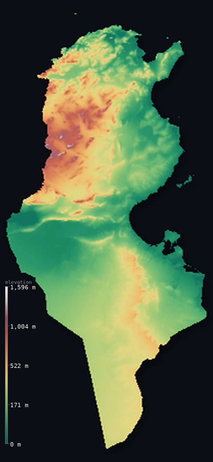
Tunisia’s highest point is Jebel ech Chambi at 5,066 ft (1,544 m); its lowest is Chott el Gharsa at −56 ft (−17 m); the mean elevation is 833 ft (254 m).
- Highest point📚
- 5,066 ft1,544 m
- Jebel ech Chambi, above Kasserine in the west-centre.
- Lowest point📚
- −56 ft−17 m
- The Chott el Gharsa salt lake, below sea level in the south.
- Mean elevation⚙
- 833 ft254 m
- Computed from the GLO-30 surface model across the country.
- Median elevation⚙
- 673 ft205 m
- Half of Tunisia lies below this height.
- Elevation range📚
- 5,121 ft1,561 m
- From about 17 m below sea level to Jebel ech Chambi's 1,544 m.
- Above 1,000 m (3,281 ft)⚙
- 1%
- The northern Dorsale and the Kroumirie ridges.
- Official area📚
- 63,170 mi²163,610 km²
- A modest-sized country from Mediterranean hills to Saharan chotts.
- Forest cover📚
- 6.6%
- Lightly wooded, the forest concentrated in the wetter northwest.
Highest and lowest points
The highest point of Tunisia, Jebel ech Chambi, 1,544 m, standing above the city of Kasserine in the west-centre of the country. A pine-forested peak of the Tunisian Dorsale - the eastern end of the Atlas Mountains - it lies a few kilometres from the Algerian border but its summit is inland, an interior high point.
source ↗Tunisia at a glance
Tunisia's lowest point, the Chott el Gharsa, lies about 17 m below sea level.
source ↗Its highest peak, Jebel ech Chambi, is the eastern end of the Atlas Mountains that stretch across the Maghreb.
source ↗The vast Chott el Djerid salt lake, dry for much of the year, has served as a filming location for desert scenes in cinema.
source ↗No land in Tunisia reaches 2,000 m, yet the country runs from Mediterranean forest to open Sahara.
source ↗The Medjerda is the only river in Tunisia that flows all year round.
source ↗
Elevation profile of Tunisia
The largest share of land, 29%, falls in the 0–100 m band, and 88% of the territory lies below 500 m (1,640 ft).
- below 500 m (1,640 ft)88%
- 500–1,000 m12%
- 1,000–2,000 m1%
Highest peaks of Tunisia
| Peak | Elevation | Range | Note |
|---|---|---|---|
| Jebel ech Chambi↗ | 5,066 ft1,544 m | Tunisian Dorsale (Atlas) | Highest point of Tunisia, a pine-forested peak above Kasserine near the Algerian border. |
| Jebel Zaghouan↗ | 4,249 ft1,295 m | Tunisian Dorsale (Atlas) | The most prominent peak in Tunisia, about 50 km southwest of Tunis, with an ancient Roman water temple at its foot. |
Terrain regions of Tunisia
Tunisia's lowest point, the Chott el Gharsa, lies about 17 m below sea level. ↗
The northern Tell and Dorsale
↗The wetter, hillier north - the forested Kroumirie and Mogods near the coast, the Medjerda valley (Tunisia's only permanent river), and the Tunisian Dorsale ridge carrying Jebel ech Chambi and Jebel Zaghouan toward Cape Bon.
The central steppe
↗The semi-arid High and Low Steppes of the centre, from about 180 to 460 m, running from Kasserine and Gafsa in the west to the olive country of Kairouan and Sfax in the east.
The chotts and Sahara
↗The southern salt lakes (chotts), including the vast Chott el Djerid and the below-sea-level Chott el Gharsa, and beyond them the dunes of the Grand Erg Oriental and the desert oases.
The northern Tell and Dorsale
the northNorthern Tunisia is the highest and greenest part of the country. The Tunisian Dorsale, the eastern tip of the Atlas Mountains, runs southwest to northeast and carries the country's highest peaks - Jebel ech Chambi (1,544 m) and Jebel Zaghouan - before tapering toward the Cape Bon peninsula. North of it lie the gentler hills and plains of the Tell and the forested Kroumirie, drained by the Medjerda, Tunisia's only permanent river.
The central steppe
the centreSouth of the Dorsale the land softens into the High and Low Steppes, a broad semi-arid belt generally between about 180 and 460 m. It runs from the west-central towns of Kasserine, Gafsa and Sidi Bouzid down to the olive-growing plains around Kairouan and Sfax in the east, marking the transition from the Mediterranean north to the pre-Saharan south.
The chotts and Sahara
the southThe south is Saharan. A line of great salt depressions, the chotts, marks the desert's northern edge: the huge Chott el Djerid and, lower still, the Chott el Gharsa, which lies about 17 m below sea level - the lowest point in the country. Beyond them stretch the dunes of the Grand Erg Oriental, the rocky Dahar plateau and scattered oasis towns like Tozeur and Douz.
City elevations in Tunisia
| City | Population | Elevation |
|---|---|---|
| TuniscapitalTunis, the capital, lies on the northeast coast by the Gulf of Tunis, where the Dorsale tapers toward the sea. ↗ | 693,210 | 89 ft27 m |
| Sfax | 280,566 | 23 ft7 m |
| Sousse | 221,715 | 66 ft20 m |
| Gabès | 110,075 | 33 ft10 m |
| Hammamet | 106,326 | 49 ft15 m |
| Gafsa | 95,242 | 974 ft297 m |
| Houmt Souk | 89,228 | 30 ft9 m |
| Ben Gardane | 87,404 | 49 ft15 m |
| KasserineKasserine sits in the west-central steppe below Jebel ech Chambi, the country's highest mountain. ↗ | 84,365 | 2,215 ft675 m |
| Medenine | 71,406 | 299 ft91 m |
Elevation sampled at each city centre from the Copernicus GLO-30 model. Cities and population from GeoNames (CC-BY 4.0).
Tunisia in comparison
Tunisia's terrain rises 5,121 ft (1,561 m) from Chott el Gharsa, 56 ft (17 m) below sea level to Jebel ech Chambi — about 18% of the height of Mount Everest, the world's highest point at 29,032 ft (8,849 m).
- Algeria's mean elevation is 1,827 ft — 994 ft higher; its high point, Mount Tahat, reaches 9,541 ft (2,908 m), 4,475 ft above. Algeria elevation map →
- Libya's mean elevation is 1,368 ft — 535 ft higher; its high point, Bikku Bitti (Bette Peak), reaches 7,438 ft (2,267 m), 2,372 ft above. Libya elevation map →
- Morocco's mean elevation is 2,060 ft — 1,227 ft higher; its high point, Jbel Toubkal, reaches 13,671 ft (4,167 m), 8,606 ft above. Morocco elevation map →
Frequently asked questions
What is the highest point in Tunisia?
- Jebel ech Chambi, 5,066 ft (1,544 m), a pine-forested peak of the Dorsale above Kasserine in the west-centre.
What is the average elevation of Tunisia?
- Computed from the Copernicus GLO-30 model, the area-weighted mean is 833 ft (254 m) - modest, as most of the country is steppe and desert.
What is the lowest point in Tunisia?
- The Chott el Gharsa salt lake in the south, about −56 ft (−17 m) - below sea level; this map treats that low ground as land.
Does any part of Tunisia rise above 2,000 m?
- No - the highest point, Jebel ech Chambi, is 1,544 m, so no land in Tunisia reaches 2,000 m.
What are the chotts?
- Large salt lakes, or salt depressions, in southern Tunisia - the biggest, Chott el Djerid, and the lower Chott el Gharsa - that mark the northern edge of the Sahara.
Is this a topographic, relief, contour, or elevation map of Tunisia?
- They describe the same thing - terrain height. This page renders Tunisia's actual elevation surface in interactive 3D (a relief or topographic view) and reports the elevation statistics computed from it; a contour map shows the same data as lines of equal height.
About this map
The terrain is rendered from the Copernicus GLO-30 digital elevation model (ESA), masked to the TUN-ADM0 boundary from geoBoundaries (gbOpen). Elevation statistics are computed directly from the model; peak names and researched facts are sourced and cited. See the methodology for the full pipeline.
Our area-weighted mean, computed from the Copernicus GLO-30 model, is 833 ft (254 m); the figure commonly cited elsewhere is 807 ft (246 m) (CIA World Factbook). Tunisia is mostly low - the Dorsale ridges of the north give way to central steppe and then to the Saharan plains and salt lakes of the south, which drop below sea level - so its mean elevation is modest; the page reports the area-weighted figure computed from the Copernicus GLO-30 model.
Surveyed national figures: official area · forest cover · high point.
Rendered from Copernicus GLO-30 (ESA, 2021 release), boundaries from geoBoundaries. Generated 2026-07-08.
Bordering countries · 2
Tunisia shares a land border with these countries — open any one to compare its terrain and highest point.