Benin Elevation Map — Topographic & 3D Terrain
Explore the terrain of Benin in interactive 3D, built from Copernicus GLO-30 satellite elevation data — a narrow country rising in gentle steps from the Bight of Benin to the low Atacora mountains. Drag to rotate, scroll to zoom, and tap any point to read its elevation.
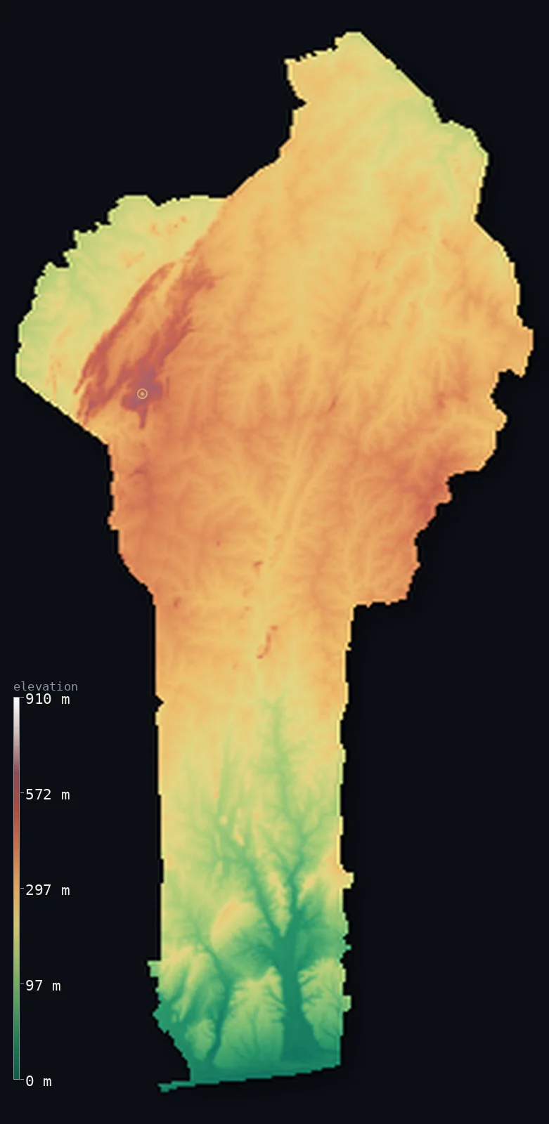
Benin’s highest point is Mont Sokbaro at 2,159 ft (658 m); its lowest is Atlantic Ocean (Bight of Benin) at 0 ft (0 m); the mean elevation is 873 ft (266 m).
Benin is a narrow West African country stretching some 700 km from the Bight of Benin north to the Niger River. It rises in gentle steps: a low, sandy coastal plain of lagoons — including Nokoué Lake, with the stilt village of Ganvié — then fertile southern plateaus, then broad central flatlands dotted with rocky inselbergs, and finally the low Atacora mountains along the Togo border, the country's only real highlands, rising to Mont Sokbaro at 2,159 ft (658 m). It is a low, even country: half of it lies below about 930 ft, and the mean sits close by, for Benin has no mountains of real height.
- Highest point📚
- 2,159 ft658 m
- Benin's highest point is Mont Sokbaro at 2,159 ft (658 m), a summit of the Atacora range on the Togo border in the northwest — the country's officially recognised high point and the crest of its only real highlands. The status is mildly contested: satellite (SRTM) data reads a point further inside Benin, near Kotopounga, a little higher (about 672 m), within the data's margin of error, but Mont Sokbaro is the conventionally cited summit.
- Lowest point📚
- 0 ft0 m
- Benin's lowest point is the Atlantic Ocean at sea level, along its short, straight 121 km coast on the Bight of Benin — a sandbar shore with no natural harbours or river mouths, backed by a chain of coastal lagoons and lakes. From this low coast the land rises gently northward, step by step, toward the interior.
- Mean elevation⚙
- 873 ft266 m
- Computed from the GLO-30 model, Benin's mean elevation is 873 ft (266 m) — low, for Benin rises only gently from the coast: a country of coastal plain, plateaus, and lateritic flatlands, with real hills only in the Atacora of the far northwest. About half the country lies below about 928 ft (283 m), and the mean and median sit close together — Benin is low and even, without great heights or depths.
- Median elevation⚙
- 928 ft283 m
- Half of Benin lies below about 928 ft (283 m) — and this figure sits close to the mean, because Benin is a low, gently rising country: coastal plain, then plateaus, then broad flatlands dotted with rocky inselbergs, and only in the far northwest the low Atacora ridges. There are no mountains of real height and no deep lowlands to pull the two apart.
- Elevation range📚
- 2,159 ft658 m
- From the Bight of Benin to the summit of Mont Sokbaro at 658 m, Benin's terrain spans only about 2,159 ft — a small range for a country stretching some 700 km inland, because Benin rises in gentle steps rather than to any great height, with the low Atacora its only real highlands.
- Official area📚
- 43,484 mi²112,622 km²
- Benin covers about 43,484 sq mi (112,622 sq km) — a narrow West African country stretching about 700 km from the Bight of Benin north to the Niger River, rising in four steps from a sandy coastal plain through southern plateaus and central flatlands to the low Atacora mountains (holding Mont Sokbaro) along the Togo border.
- Forest cover📚
- 30%
- About 30% of Benin is forested — a gradient from the Guinean forest-savanna mosaic of the wetter south, through wooded savanna across the central plateaus, to drier Sudanian woodland in the north, with gallery forest along the river valleys.
Highest and lowest points
A summit of the Atacora range on the Benin–Togo border — the conventionally and officially recognised highest point of Benin at 658 m. The status is mildly contested: NASA SRTM readings put a point further inside Benin (near Kotopounga/Tanekas) at about 672 m, within the mission's ~16 m error margin, but the CIA Factbook and Benin's own references list Mont Sokbaro.
source ↗Benin's lowest point is the Atlantic Ocean at sea level, along a short, straight 121 km coast on the Bight of Benin — a sandbar shore with no natural harbours, river mouths, or islands, backed by a chain of lagoons and lakes, including Nokoué Lake between the largest city, Cotonou, and the capital, Porto-Novo, where the stilt village of Ganvié stands over the water. Behind the coast Benin rises gently and evenly northward: the southern plateaus split by the Ouémé, Couffo, and Zou river valleys; the central lateritic flatlands with their isolated inselbergs around Nikki and Savé; and, in the far northwest, the low quartzite ridges of the Atacora, the country's watershed and its only real mountains. From the Atacora, streams run north to the Niger and south to the coastal rivers and lagoons — a low country whose height is gathered in one far corner.
source ↗Benin at a glance
Benin's highest point is contested: Mont Sokbaro (658 m) is the official summit, but NASA SRTM data reads a point further inside the country slightly higher — within the satellite's margin of error.
source ↗Benin is remarkably low and flat: its coastal plain reaches only about 10 m, and real mountains appear only in the Atacora of the far northwest.
source ↗The Atacora range is Benin's watershed — from its ridges streams run north to the Niger River and south to the coastal rivers and lagoons.
source ↗Benin's 121 km coast is a straight sandbar with no natural harbours, river mouths or islands — backed by a chain of lagoons rather than open shore.
source ↗Nokoué Lake, the country's largest lagoon, lies between Benin's two biggest cities, Cotonou and the capital Porto-Novo, and hosts the stilt village of Ganvié.
source ↗The dry, dusty harmattan wind blows off the Sahara from December to March, drying the grass, reddening the vegetation and veiling the skies in fine dust.
source ↗Benin is a narrow, key-shaped strip stretching about 700 km from the Niger River in the north to the Atlantic in the south, but only ~325 km across at its widest.
source ↗
Elevation profile of Benin
The largest share of land, 20%, falls in the 300–350 m band, and 99% of the territory lies below 500 m (1,640 ft).
- below 500 m (1,640 ft)99%
- 500–1,000 m1%
Highest peaks of Benin
| Peak | Elevation | Range | Note |
|---|---|---|---|
| Tanekas (SRTM high point)↗ | 2,205 ft672 m | Atacora | A point further inside Benin near Kotopounga that SRTM data reads slightly higher than Sokbaro; the difference falls within satellite error margins. |
| Mont Sokbaro↗ | 2,159 ft658 m | Atacora | Officially the highest point of Benin, on the Togo border in the Atacora quartzite massif. |
| Mont Goubono↗ | 2,044 ft623 m | Atacora foothills | A prominent hill in the centre-west near Bassila, among the higher summits after Sokbaro. |
| Atacora ridge (Natitingou area)↗ | 1,969 ft600 m | Atacora | The main spine of the Atacora range running northeast–southwest above Natitingou, a natural watershed. |
| Nikki–Savé rocky hills↗ | 1,312 ft400 m | central plateau inselbergs | Isolated rocky hills (inselbergs) rising from the flat central plateau around Nikki and Savé, seldom above 400 m. |
Benin: the coastal plain, the plateaus and flatlands, and the Atacora
The coastal plain
A low, marshy, sandy strip along the 121 km Bight of Benin coast, dotted with lagoons and lakes — including Nokoué Lake between Cotonou and the capital Porto-Novo. The country's low, watery seaward edge.
The southern plateaus
Fertile plateaus inland from the coast, split by the north–south valleys of the Couffo, Zou, and Ouémé rivers — the Guinean forest-savanna mosaic where much of the population lives.
The central flatlands
A broad lateritic plateau of wooded savanna around Nikki and Savé, dotted with isolated rocky hills (inselbergs) that seldom exceed 400 m. The low, level heart of the country.
The Atacora mountains
A low quartzite range along the northwest border with Togo — Benin's only real highlands, rising to Mont Sokbaro, and its watershed, sending streams north to the Niger and south to the coast.
How to read this map
Color shows elevation; the raised relief shows real terrain. On this map Benin reads as a low country rising gently northward — the low green of the coastal plain and the plateaus filling most of it, scattered rocky inselbergs in the centre, and the browns of the low Atacora ridges along the northwest border (highest at Mont Sokbaro) the one real high ground.
Because the country is largely low, the 3D exaggeration is what makes the Atacora and the inselbergs stand out; the ×N relief slider controls how much. Tap anywhere to read that point's exact elevation.
City elevations in Benin
Benin's cities cluster in the wetter south, near the coast — Cotonou, the largest, on the Gulf of Guinea between the sea and Nokoué Lake, with the capital Porto-Novo beside it — while Parakou, Djougou, and Natitingou lie inland across the plateaus and, in the northwest, below the Atacora. Most of the population lives low, in the south.
| City | Population | Elevation |
|---|---|---|
| Cotonouthe largest city, on the coast between the sea and Nokoué Lake ↗ | 679,012 | 23 ft7 m |
| Porto-Novocapitalthe capital, on a lagoon near the coast ↗ | 264,320 | 66 ft20 m |
| Parakouin the central plateau country ↗ | 255,478 | 1,191 ft363 m |
| Abomeyon the southern plateau ↗ | 117,824 | 745 ft227 m |
| Djougouin the northwest, toward the Atacora ↗ | 94,773 | 1,450 ft442 m |
| Nikki | 66,109 | 1,312 ft400 m |
| Malanvillein the far north, on the Niger River ↗ | 64,639 | 531 ft162 m |
| Kandiin the northern savanna ↗ | 56,043 | 958 ft292 m |
| Kérou | 54,276 | 1,073 ft327 m |
| Natitingouin the northwest, below the Atacora mountains ↗ | 53,284 | 1,473 ft449 m |
Elevation sampled at each city centre from the Copernicus GLO-30 model. Cities and population from GeoNames (CC-BY 4.0).
Benin in comparison
Benin's terrain rises 2,159 ft (658 m) from sea level to Mont Sokbaro — about 7% of the height of Mount Everest, the world's highest point at 29,032 ft (8,849 m).
- Togo's mean elevation is 850 ft — 23 ft lower; its high point, Mont Agou, reaches 3,235 ft (986 m), 1,076 ft above. Togo elevation map →
- Nigeria's mean elevation is 1,073 ft — 200 ft higher; its high point, Chappal Waddi, reaches 7,936 ft (2,419 m), 5,778 ft above. Nigeria elevation map →
- Burkina Faso's mean elevation is 978 ft — 105 ft higher; its high point, Mount Tenakourou, reaches 2,457 ft (749 m), 299 ft above. Burkina Faso elevation map →
Frequently asked questions
What is the highest point in Benin?
- Mont Sokbaro, 2,159 ft (658 m), a summit of the Atacora range on the Togo border in the northwest - the country's officially recognised high point.
Is Mont Sokbaro really the highest point in Benin?
- It is the official and conventionally cited summit (658 m), but satellite (SRTM) data reads a point further inside Benin, near Kotopounga, a little higher - within the data's margin of error. Mont Sokbaro remains the recognised high point.
What is the average elevation of Benin?
- Computed from the Copernicus GLO-30 model, the area-weighted mean is 873 ft (266 m). Benin is low and gently rising, so the mean and median (about 928 ft (283 m)) sit close together, with real hills only in the Atacora of the northwest.
Is Benin flat or mountainous?
- Mostly low and gently rising - coastal plain, plateaus, and flatlands - with real hills only in the low Atacora range of the far northwest, rising to Mont Sokbaro (658 m). Benin has no mountains of great height.
What is the Atacora?
- A low range of ancient quartzite ridges along Benin's northwest border with Togo - the country's only true highlands, rising to Mont Sokbaro, and its watershed, sending streams north to the Niger and south to the coast.
Is this a topographic, relief, contour, or elevation map of Benin?
- They describe the same thing - terrain height. This page renders Benin's actual elevation surface in interactive 3D and reports the statistics computed from it.
About this map
The terrain is rendered from the Copernicus GLO-30 digital elevation model (ESA), masked to the BEN-ADM0 boundary from geoBoundaries (gbOpen). Elevation statistics are computed directly from the model; peak names and researched facts are sourced and cited. See the methodology for the full pipeline.
Our area-weighted mean, computed from the Copernicus GLO-30 model, is 873 ft (266 m); the figure commonly cited elsewhere is 896 ft (273 m) (CIA World Factbook). Benin is a low, gently rising country that climbs from the coast to the interior in four steps: a sandy coastal plain of lagoons, then fertile southern plateaus, then broad central flatlands dotted with rocky inselbergs, and finally the low Atacora mountains along the Togo border in the far northwest — the country's only real highlands, rising to Mont Sokbaro. Because there are no mountains of real height and no deep lowlands, the mean and median sit close together, both low: half of Benin lies below about 928 ft (283 m). It is an even, low country, its relief a gentle northward rise rather than a matter of peaks and valleys.
Surveyed national figures: official area · forest cover · high point.
Rendered from Copernicus GLO-30 (ESA, 2021 release), boundaries from geoBoundaries. Generated 2026-06-22.
Bordering countries · 4
Benin shares a land border with these countries — open any one to compare its terrain and highest point.