Tanzania Elevation Map — Topographic & 3D Terrain
Explore the terrain of Tanzania in interactive 3D, built from Copernicus GLO-30 satellite elevation data — a vast East African country from the Indian Ocean coast to Kilimanjaro, the highest point in Africa. Drag to rotate, scroll to zoom, and tap any point to read its elevation.
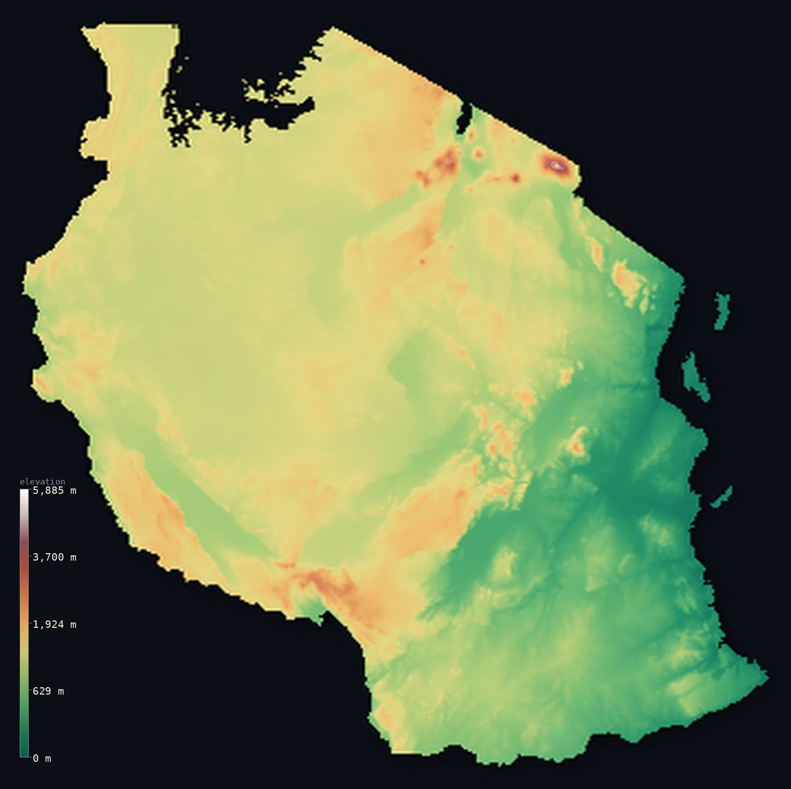
Tanzania’s highest point is Kilimanjaro (Uhuru Peak) at 19,341 ft (5,895 m); its lowest is Indian Ocean at 0 ft (0 m); the mean elevation is 3,340 ft (1,018 m).
Tanzania rises from the Indian Ocean to the roof of a continent. A low, tropical coastal plain along the east — with the islands of Zanzibar and Pemba offshore — gives way inland to a vast high central plateau, and to the mountains and volcanoes of the East African Rift. In the northeast stands Kilimanjaro, a huge free-standing volcano reaching 19,341 ft (5,895 m) — the highest point in Africa. The Great Rift Valley splits the north into two branches, cradling great lakes on the country's borders and studding the highlands with volcanoes and craters.
- Highest point📚
- 19,341 ft5,895 m
- Tanzania's highest point is Kilimanjaro at 19,341 ft (5,895 m) — the highest mountain in Africa, and the tallest free-standing mountain in the world, rising alone from the plains of the northeast in a vast volcanic cone crowned with shrinking glaciers and snow, despite standing only a few degrees from the equator. It towers far above everything else on the continent, a solitary giant on the Tanzanian plateau.
- Lowest point📚
- 0 ft0 m
- Tanzania's lowest point is the Indian Ocean at sea level, along its tropical eastern coast of beaches, mangroves, and the old Swahili ports, with the islands of Zanzibar and Pemba lying just offshore.
- Mean elevation⚙
- 3,340 ft1,018 m
- Computed from the GLO-30 model, Tanzania's mean elevation is 3,340 ft (1,018 m) — a fairly high figure for so large a country, reflecting the vast central plateau that lifts most of the interior well above the sea, with only the coastal plain low and the rift mountains and Kilimanjaro rising far higher.
- Median elevation⚙
- 3,691 ft1,125 m
- Half of Tanzania lies above about 3,691 ft (1,125 m) — a high median that reflects the dominance of the interior plateau: most of the country is high tableland lying above 1,000 m, with the low coastal strip and the rift-valley floors the main exceptions, and the great volcanoes the high extreme.
- Elevation range📚
- 19,341 ft5,895 m
- From the Indian Ocean to the summit of Kilimanjaro at 5,895 m, Tanzania's terrain climbs about 19,340 ft — an enormous range, from a tropical sea-level coast to the glaciered roof of Africa, most of the country held on the high plateau between.
- Above 1,000 m (3,281 ft)⚙
- 63%
- About 63% of Tanzania rises above 1,000 m (3,281 ft) — the vast central plateau and the highlands, which cover most of the interior. The coastal plain in the east and the rift-valley floors lie lower.
- Above 2,000 m (6,562 ft)⚙
- 2%
- Roughly 2% of Tanzania stands above 2,000 m (6,562 ft) — the higher highlands and mountains, the volcanic ranges of the north and south around the rift, rising to Kilimanjaro, Meru, and the Ngorongoro highlands.
- Official area📚
- 365,756 mi²947,303 km²
- Tanzania covers about 365,800 sq mi (947,303 sq km) — a large East African country on the Indian Ocean, with a low coastal plain, a vast high interior plateau, the mountains and lakes of the Great Rift Valley, and Kilimanjaro, the highest point in Africa.
- Forest cover📚
- 51.6%
- About 52% of Tanzania is forested or wooded — much of the plateau carries miombo woodland and savanna, with rainforest on the wetter mountain slopes, mangroves along the coast, and the open grasslands of the Serengeti in the north.
Highest and lowest points
Tanzania's highest point is Kilimanjaro, 19,341 ft (5,895 m) — the highest mountain in Africa and the highest free-standing mountain on Earth, rising in isolation from the northern plains in a vast volcanic massif of three cones, the highest being Kibo. Its summit, Uhuru Peak, carries glaciers and snow year-round despite lying just three degrees south of the equator, though the ice is shrinking fast. Kilimanjaro stands far above anything else in Africa — its nearest rival, Mount Kenya, is over 600 m lower — a solitary giant visible across the plains for a hundred miles. Nearby rises Mount Meru, another great volcano, and beyond it the craters and highlands of the rift, but Kilimanjaro is the roof of the continent.
source ↗Tanzania's lowest point is the Indian Ocean at sea level, along a tropical eastern coast of white beaches, mangrove creeks, coral reefs, and the historic Swahili trading ports such as Dar es Salaam and old Bagamoyo. Just offshore lie the islands of Zanzibar and Pemba, low and green. Behind this narrow coastal plain the land rises fairly quickly onto the great interior plateau that makes up most of Tanzania — so that the low coast, though famous, is a thin eastern margin of a high country.
source ↗Tanzania at a glance
Kilimanjaro (5,895 m) is the highest free-standing mountain in the world, rising about 4,900 m straight from the plains.
source ↗Its summit glaciers have lost more than 80 percent of their ice since 1912 and may vanish within decades.
source ↗Tanzania holds Africa's highest point (Kilimanjaro) and, in Lake Tanganyika, the continent's deepest lake.
source ↗Both arms of the East African Rift run through the country, lined with volcanoes and lakes.
source ↗Despite the towering volcanoes, most of Tanzania is a single high plateau of savanna.
source ↗
Elevation profile of Tanzania
The largest share of land, 51%, falls in the 1,000–1,500 m band, and 81% of the territory lies above 500 m (1,640 ft).
- below 500 m (1,640 ft)19%
- 500–1,000 m18%
- 1,000–2,000 m61%
- above 2,000 m (6,562 ft)2%
Highest peaks of Tanzania
| Peak | Elevation | Range | Note |
|---|---|---|---|
| Kilimanjaro (Uhuru Peak)↗ | 19,341 ft5,895 m | Eastern Rift volcanoes | Highest point of Tanzania and Africa, the Uhuru Peak summit on Kilimanjaro's Kibo cone. |
| Mawenzi↗ | 16,893 ft5,149 m | Kilimanjaro massif | Kilimanjaro's second, jagged cone, 5,149 m — a subsidiary summit of the Kilimanjaro massif. |
| Mount Meru↗ | 14,967 ft4,562 m | Eastern Rift volcanoes | An active volcano near Arusha, 4,562 m — Tanzania's second-highest mountain, close to Kilimanjaro. |
| Mount Hanang↗ | 11,220 ft3,420 m | Eastern Rift volcanoes | An extinct volcano rising from the plateau in north-central Tanzania. |
| Rungwe↗ | 9,715 ft2,961 m | Southern Highlands | A volcano of the Southern Highlands, near the northern tip of Lake Nyasa. |
Tanzania: the coast, the plateau, and the rift
The coastal plain and islands
Along Tanzania's Indian Ocean edge runs a low, tropical coastal plain — beaches, mangroves, coral coast, and the Swahili ports — with the islands of Zanzibar and Pemba just offshore. Narrow and low, it is the country's warm, humid seaward margin.
The central plateau
Most of Tanzania is a vast high plateau — rolling tableland of savanna and miombo woodland lying above 1,000 m, stretching across the interior and holding much of the country's land and farming. High, open, and dry in parts, it is the country's great core.
The rift, the highlands, and the volcanoes
The Great Rift Valley cuts through Tanzania in two branches, cradling great border lakes and lifting highlands and volcanoes — Kilimanjaro and Meru in the northeast, the Ngorongoro and Crater Highlands, the Southern Highlands. The country's highest, most dramatic, and most fertile ground.
How to read this map
Color shows elevation; the raised relief shows real terrain. On this map Tanzania reads as a high plateau between a low coast and high volcanoes — the narrow green coastal plain and the offshore islands in the east, the vast mid-toned plateau filling the interior, and the browns and whites of the rift highlands and the great volcanoes, Kilimanjaro towering highest in the northeast.
The 3D relief is the actual GLO-30 elevation data, exaggerated vertically so the coast, plateau, and volcanoes all show; the ×N relief slider controls how much. Tap anywhere to read that point's exact elevation.
City elevations in Tanzania
Tanzania's cities spread across the country — Dar es Salaam and Tanga low on the Indian Ocean coast; Dodoma (the capital), Tabora, and Kahama on the central plateau; Mwanza on Lake Victoria; Arusha in the northern highlands near Kilimanjaro; and Mbeya and Sumbawanga high in the Southern Highlands. They sit low on the coast or high on the plateau.
| City | Population | Elevation |
|---|---|---|
| Dar es Salaamthe largest city and main port, on the Indian Ocean coast ↗ | 5,383,728 | 66 ft20 m |
| Mwanzaon the shore of Lake Victoria in the north ↗ | 1,104,521 | 3,747 ft1,142 m |
| Dodomacapitalthe capital, on the central plateau ↗ | 765,179 | 3,681 ft1,122 m |
| Arushain the northern highlands near Kilimanjaro and Meru ↗ | 617,631 | 4,652 ft1,418 m |
| Mbeyain the Southern Highlands, high in the southwest ↗ | 541,603 | 5,551 ft1,692 m |
| Morogoroat the foot of the Uluguru Mountains, east of the plateau ↗ | 471,409 | 1,647 ft502 m |
| Kahamaon the central-western plateau ↗ | 453,654 | 4,088 ft1,246 m |
| Tangaa northern port on the Indian Ocean coast ↗ | 393,429 | 72 ft22 m |
| Taborain the west-central plateau ↗ | 308,741 | 3,898 ft1,188 m |
| Sumbawangahigh in the far southwest, near Lake Rukwa ↗ | 303,986 | 5,981 ft1,823 m |
Elevation sampled at each city centre from the Copernicus GLO-30 model. Cities and population from GeoNames (CC-BY 4.0).
Tanzania in comparison
Tanzania's terrain rises 19,341 ft (5,895 m) from sea level to Kilimanjaro (Uhuru Peak) — about 67% of the height of Mount Everest, the world's highest point at 29,032 ft (8,849 m).
- Kenya's mean elevation is 2,575 ft — 764 ft lower; its high point, Mount Kenya (Batian), reaches 17,057 ft (5,199 m), 2,283 ft below. Kenya elevation map →
- Uganda's mean elevation is 3,822 ft — 482 ft higher; its high point, Margherita Peak (Mount Stanley), reaches 16,762 ft (5,109 m), 2,579 ft below. Uganda elevation map →
- Malawi's mean elevation is 3,104 ft — 236 ft lower; its high point, Sapitwa Peak (Mount Mulanje), reaches 9,849 ft (3,002 m), 9,491 ft below. Malawi elevation map →
Frequently asked questions
What is the highest point in Tanzania?
- Kilimanjaro, 19,341 ft (5,895 m) — the highest mountain in Africa and the tallest free-standing mountain in the world, a glaciered volcano rising alone from the northern plains.
What is the lowest point in Tanzania?
- The Indian Ocean at sea level, along the tropical eastern coast, with Zanzibar and Pemba offshore.
What is the average elevation of Tanzania?
- Computed from the Copernicus GLO-30 model, the area-weighted mean is 3,340 ft (1,018 m) — fairly high, because a vast interior plateau lifts most of the country above 1,000 m, with only the coast and rift floors low.
How high is Kilimanjaro?
- 19,341 ft (5,895 m) — the highest point in Africa, a free-standing volcano whose summit carries shrinking glaciers despite lying near the equator, over 600 m higher than its nearest rival, Mount Kenya.
What is the Great Rift Valley in Tanzania?
- A great split in the Earth's crust running through northern Tanzania in two branches — cradling the border lakes Victoria, Tanganyika, and Malawi and raising volcanoes and craters like Ngorongoro along its length.
Is this a topographic, relief, contour, or elevation map of Tanzania?
- They describe the same thing — terrain height. This page renders the country's actual elevation surface in interactive 3D and reports the statistics computed from it.
About this map
The terrain is rendered from the Copernicus GLO-30 digital elevation model (ESA), masked to the TZA-ADM0 boundary from geoBoundaries (gbOpen). Elevation statistics are computed directly from the model; peak names and researched facts are sourced and cited. See the methodology for the full pipeline.
Our area-weighted mean, computed from the Copernicus GLO-30 model, is 3,340 ft (1,018 m); the figure commonly cited elsewhere is 3,340 ft (1,018 m) (CIA World Factbook). A vast high plateau lifts most of Tanzania's interior above 1,000 m, with only the coastal plain and the rift-valley floors low and the great volcanoes far higher, so its area-weighted mean is fairly high. The figure computed here from the Copernicus GLO-30 model, about 1,018 m, matches the 1,018 m cited by the CIA World Factbook.
Surveyed national figures: official area · forest cover · high point.
Rendered from Copernicus GLO-30 (ESA, 2021 release), boundaries from geoBoundaries. Generated 2026-07-07.
Bordering countries · 7
Tanzania shares a land border with these countries — open any one to compare its terrain and highest point.