Burundi Elevation Map — Topographic & 3D Terrain
Explore the terrain of Burundi in interactive 3D, built from Copernicus GLO-30 satellite elevation data — a high, hilly country on the Congo-Nile Divide above Lake Tanganyika. Drag to rotate, scroll to zoom, and tap any point to read its elevation.
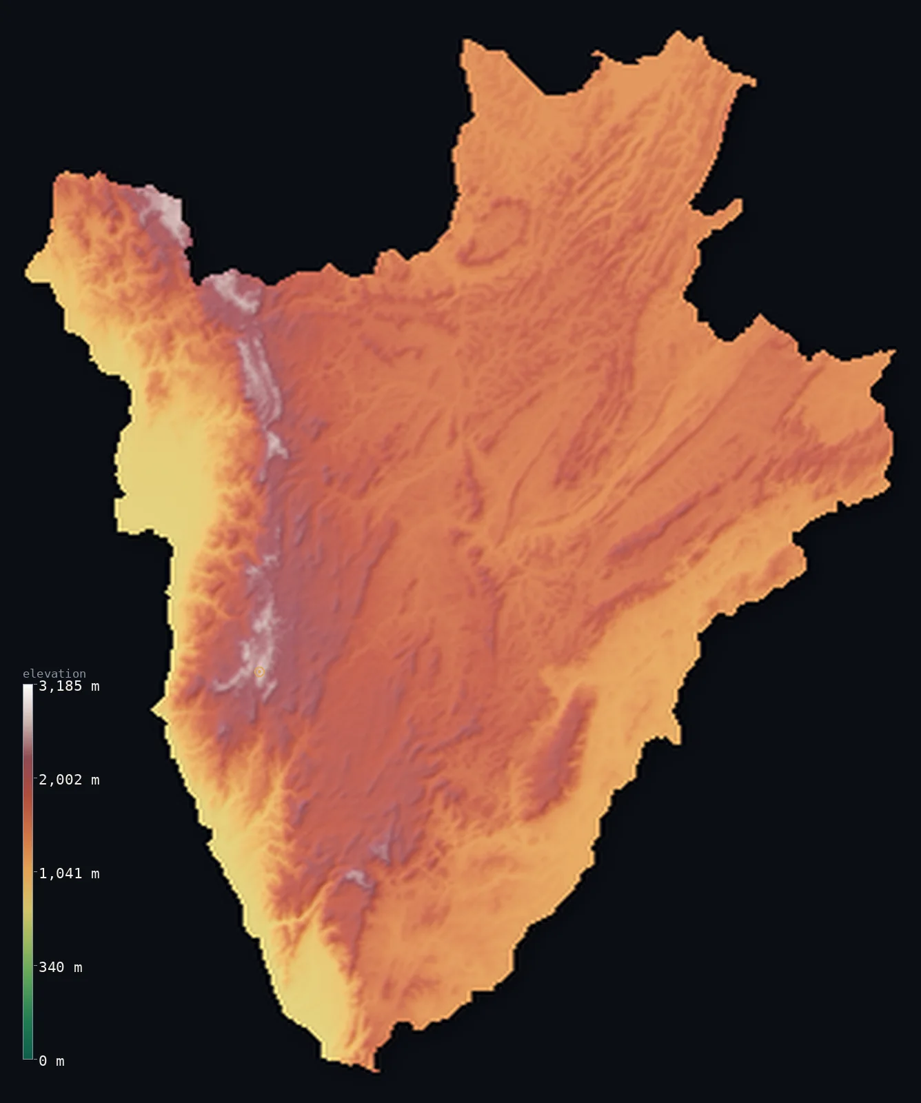
Burundi’s highest point is Mount Heha at 8,806 ft (2,684 m); its lowest is Lake Tanganyika at 2,533 ft (772 m); the mean elevation is 5,125 ft (1,562 m).
Burundi is a small, high, hilly country in the Great Lakes region of Africa — steep highland from end to end but for one dramatic drop. Most of it is a densely terraced upland of hills and ridges, folded and eroded rather than volcanic; then, along the west, the land plunges off the Congo-Nile Divide down a steep escarpment to Lake Tanganyika in the Great Rift Valley, whose shore, far below, is the country's lowest ground. The highest point, Mount Heha, reaches 8,806 ft (2,684 m) on the divide. From this eastern side rises one of the most distant headwaters of the Nile — the country's water shed either to the Atlantic or, after 6,000 km, to the Mediterranean.
- Highest point📚
- 8,806 ft2,684 m
- Burundi's highest point is Mount Heha at 8,806 ft (2,684 m), on the Congo-Nile Divide southeast of Bujumbura — the highest of the high crest that runs down western Burundi, well above the hills that make up most of the country. It stands on the watershed between the Congo and Nile river systems, the roof of a high land.
- Lowest point📚
- 2,533 ft772 m
- Burundi's lowest point is the shore of Lake Tanganyika in the southwest at about 2,533 ft (772 m) — the surface of the great rift lake, into which the country's western slopes drain. Though it is the lowest ground in Burundi, it still lies well above 750 m, at the foot of the steep drop from the highlands to the rift.
- Mean elevation⚙
- 5,125 ft1,562 m
- Computed from the GLO-30 model, Burundi's mean elevation is 5,125 ft (1,562 m) — high, the elevation of a country that is all hills and no lowland but for the rift: ridges above 1,400 m cover it from the Congo-Nile Divide in the west to the eastern valleys, dropping only at the plunge to Lake Tanganyika.
- Median elevation⚙
- 5,164 ft1,574 m
- Half of Burundi lies above about 5,164 ft (1,574 m) — and unusually, the median sits above the mean: the steep plunge to Lake Tanganyika and the rift floor drags the average below the height of the typical hill, so the middle of the country stands higher than its average.
- Elevation range📚
- 6,273 ft1,912 m
- Burundi's terrain spans about 6,270 ft — Lake Tanganyika's shore at 772 m up to Mount Heha at 2,684 m — and almost all of that rise is packed into the steep western escarpment, where the highland drops abruptly to the rift; away from that wall, the country is gently rolling high hills.
- Above 1,000 m (3,281 ft)⚙
- 94%
- About 94% of Burundi rises above 1,000 m (3,281 ft) — which is most of the country, since Burundi is high hill country throughout. The lower ground is confined to the shore of Lake Tanganyika and the Ruzizi valley in the west.
- Above 2,000 m (6,562 ft)⚙
- 8%
- Roughly 8% of Burundi stands above 2,000 m (6,562 ft) — the higher hills and the Congo-Nile Divide of the west and centre, the country's highest ground, around Mount Heha.
- Official area📚
- 10,745 mi²27,830 km²
- Burundi covers about 10,700 sq mi (27,830 sq km) — a small, landlocked, high country in the Great Lakes region of central-eastern Africa, steep hill country astride the Congo-Nile Divide, falling to Lake Tanganyika in the western rift.
- Forest cover📚
- 10.7%
- About 11% of Burundi is forested — some montane forest survives on the Congo-Nile Divide (the Kibira forest), but much of the country's hills are intensively terraced and farmed, a densely settled and cultivated highland.
Highest and lowest points
Burundi's highest point is Mount Heha, 8,806 ft (2,684 m), on the Congo-Nile Divide southeast of the lakeside capital, Bujumbura. It is the highest of the high crest that runs down the western side of the country — the watershed dividing the rivers that flow west to Lake Tanganyika and the Congo from those that flow east and north to the Nile. Unlike neighbouring Rwanda, Burundi has no volcanoes; its high ground is the folded, eroded highland of the divide, steep and green. One source of the Ruvyironza River here, on these highlands, is often cited as the southernmost or most distant headwater of the Nile — the great river's remotest beginning, thousands of miles from its Mediterranean mouth. Below the divide, Burundi rolls away in high hills to the east and drops sharply to the rift and Lake Tanganyika in the west.
source ↗Burundi's lowest point is the shore of Lake Tanganyika, at about 2,533 ft (772 m) above sea level — the surface of the world's second-deepest lake, which forms Burundi's southwestern border in the floor of the Great Rift Valley. From this shore the land climbs steeply eastward, up a high escarpment, onto the hills and ridges that make up most of the country. The western spine of those highlands is the Congo-Nile Divide, a watershed of remarkable reach: rain falling on its eastern flank feeds the Ruvyironza, whose source is often counted as the Nile's most remote or southernmost beginning, bound after some 6,000 km for the Mediterranean — while rain a few ridges to the west falls to Lake Tanganyika and the Congo, and so to the Atlantic.
source ↗Burundi at a glance
Burundi straddles the Congo–Nile Divide — the watershed between Africa's two greatest river basins — and holds what is often cited as the farthest headwater of the Nile, the Ruvyironza River.
source ↗Because it is landlocked and high, Burundi's lowest point is not the sea but Lake Tanganyika at 772 m — one of the deepest and oldest lakes on Earth.
source ↗Over barely 200 km west to east, Burundi's land climbs from 772 m at Lake Tanganyika to over 2,600 m on the Congo–Nile Ridge before stepping back down to the eastern plateaus.
source ↗Burundi is one of the most densely populated countries in Sub-Saharan Africa — more than 14 million people on 27,830 km², around 500 per km², farming nearly every hillside.
source ↗Its high altitude keeps Burundi cool for the tropics — the central plateau averages about 20 °C year-round, dropping below 15 °C at night in the highest areas.
source ↗Burundi's hilly landscape of cultivated 'collines' gives it a reputation, shared with Rwanda, as a land of a thousand hills.
source ↗Mount Heha's summit is a broad grassy dome rather than a sharp peak, and lies within the Albertine Rift Endemic Bird Area, rich in rare highland birds.
source ↗
Elevation profile of Burundi
The largest share of land, 28%, falls in the 1,400–1,600 m band, and 100% of the territory lies above 500 m (1,640 ft).
- 500–1,000 m6%
- 1,000–2,000 m86%
- above 2,000 m (6,562 ft)8%
Highest peaks of Burundi
| Peak | Elevation | Range | Note |
|---|---|---|---|
| Mount Heha↗ | 8,806 ft2,684 m | Congo–Nile Ridge (Burundi Highlands) | Highest point of Burundi, a rounded grassy summit on the Congo–Nile Divide near Bujumbura. |
| Mount Teza area high ground↗ | 8,743 ft2,665 m | Congo–Nile Ridge | High ground of the Congo–Nile Ridge in the northwest near the Kibira forest, among the country's highest. |
| Congo–Nile Ridge crest↗ | 8,530 ft2,600 m | Congo–Nile Ridge | The main crest line of the divide, with numerous summits beyond 2,600 m along narrow north–south ridges. |
| Kibira highlands↗ | 8,202 ft2,500 m | Congo–Nile Ridge (Kibira) | The forested highlands of Kibira National Park in the northwest, part of the Albertine Rift montane forests. |
| Central plateau high ground↗ | 6,562 ft2,000 m | central plateau | The hilly central tableland east of the ridge, mostly 1,500–2,000 m, the densely farmed heart of Burundi. |
Burundi: the central and eastern hills, the Congo-Nile Divide, and the rift
The central and eastern hills
The bulk of Burundi is high hill country — a densely settled expanse of terraced collines and valleys, cultivated to the ridgelines and sloping gently eastward toward the Kagera and the Tanzanian border. The intensively farmed heart of the country.
The Congo-Nile Divide (the west)
The western spine of the country is the Congo-Nile Divide — a high forested crest (the Kibira reserve) topped by Mount Heha, the high point. It is the continental watershed: rain on its eastern flank starts one of the Nile's most distant journeys, while the western side drains to Lake Tanganyika and the Congo.
The western rift and Lake Tanganyika
West of the divide the land drops steeply — down a high escarpment to the floor of the Great Rift Valley, the Ruzizi plain, and the shore of Lake Tanganyika (the country's lowest point), where the lakeside capital, Bujumbura, sits. The low, warm rift edge below the highlands.
How to read this map
Color shows elevation; the raised relief shows real terrain. On this map Burundi reads as a high, hilly country dropping to a rift lake — high-toned ridges and valleys covering most of it, rising along the western Congo-Nile Divide (highest at Mount Heha), then falling sharply on the west to the dark sheet of Lake Tanganyika in the Great Rift Valley.
The 3D relief is the actual GLO-30 elevation data, exaggerated vertically so the high hills and the steep drop to the rift both show; the ×N relief slider controls how much. Tap anywhere to read that point's exact elevation.
City elevations in Burundi
Burundi's cities include Bujumbura, the largest, on the shore of Lake Tanganyika, Gitega, the political capital, in the central highlands, and others among the hills. The lakeside and the high interior each hold major towns.
| City | Population | Elevation |
|---|---|---|
| Bujumburathe largest city, on the shore of Lake Tanganyika ↗ | 769,317 | 2,631 ft802 m |
| Gitegacapitalthe political capital, in the central highlands ↗ | 64,904 | 5,522 ft1,683 m |
| Ngoziin the northern hills ↗ | 61,716 | 5,971 ft1,820 m |
| Mpandain the west, near the Ruzizi plain ↗ | 58,913 | 2,881 ft878 m |
| Rumongeon Lake Tanganyika, in the south ↗ | 55,599 | 2,585 ft788 m |
| Cibitokein the northwest, on the Ruzizi plain ↗ | 36,959 | 3,064 ft934 m |
| Kayanzain the northern highlands ↗ | 33,682 | 6,257 ft1,907 m |
| Cendajuruin the east ↗ | 32,458 | 4,495 ft1,370 m |
| Vyandain the southern highlands ↗ | 29,685 | 6,066 ft1,849 m |
| Zanandorein the centre-east ↗ | 27,867 | 5,062 ft1,543 m |
Elevation sampled at each city centre from the Copernicus GLO-30 model. Cities and population from GeoNames (CC-BY 4.0).
Burundi in comparison
Burundi's terrain rises 6,273 ft (1,912 m) from Lake Tanganyika (2,533 ft (772 m)) to Mount Heha — about 22% of the height of Mount Everest, the world's highest point at 29,032 ft (8,849 m).
- Rwanda's mean elevation is 5,610 ft — 486 ft higher; its high point, Mount Karisimbi, reaches 14,787 ft (4,507 m), 5,981 ft above. Rwanda elevation map →
- Democratic Republic of the Congo's mean elevation is 2,244 ft — 2,881 ft lower; its high point, Margherita Peak (Mount Stanley), reaches 16,762 ft (5,109 m), 7,956 ft above. Democratic Republic of the Congo elevation map →
- Tanzania's mean elevation is 3,340 ft — 1,785 ft lower; its high point, Kilimanjaro (Uhuru Peak), reaches 19,341 ft (5,895 m), 10,535 ft above. Tanzania elevation map →
- Uganda's mean elevation is 3,822 ft — 1,302 ft lower; its high point, Margherita Peak (Mount Stanley), reaches 16,762 ft (5,109 m), 7,956 ft above. Uganda elevation map →
Frequently asked questions
What is the highest point in Burundi?
- Mount Heha, 8,806 ft (2,684 m), on the Congo-Nile Divide southeast of Bujumbura — the highest of the high crest running down western Burundi.
What is the lowest point in Burundi?
- The shore of Lake Tanganyika, at about 2,533 ft (772 m) — the world's second-deepest lake, in the Great Rift Valley on the western border, though still high above the sea.
What is the average elevation of Burundi?
- Computed from the Copernicus GLO-30 model, the area-weighted mean is 5,125 ft (1,562 m) — high, because Burundi is mostly steep highland, rising to the Congo-Nile Divide and falling to Lake Tanganyika.
Where is the source of the Nile in Burundi?
- In Burundi's highlands rises a source of the Ruvyironza River, often cited as the most remote or southernmost headwater of the Nile — the great river's most distant beginning.
Does Burundi have volcanoes?
- No — unlike neighbouring Rwanda, Burundi's high ground is folded, eroded highland rather than volcanic peaks. Its highest point, Mount Heha (2,684 m), is on the Congo-Nile Divide.
Is this a topographic, relief, contour, or elevation map of Burundi?
- They describe the same thing — terrain height. This page renders the country's actual elevation surface in interactive 3D and reports the statistics computed from it.
About this map
The terrain is rendered from the Copernicus GLO-30 digital elevation model (ESA), masked to the BDI-ADM0 boundary from geoBoundaries (gbOpen). Elevation statistics are computed directly from the model; peak names and researched facts are sourced and cited. See the methodology for the full pipeline.
Our area-weighted mean, computed from the Copernicus GLO-30 model, is 5,125 ft (1,562 m); the figure commonly cited elsewhere is 5,577 ft (1,700 m) (regional estimate). No single authority publishes a mean elevation for Burundi; the ~1,700 m figure often quoted is a regional estimate that runs above the 1,562 m computed here from GLO-30 — lower because the steep plunge to Lake Tanganyika and the eastern valleys pull the area-weighted average down below the height of the typical hill.
Surveyed national figures: official area · forest cover · high point.
Rendered from Copernicus GLO-30 (ESA, 2021 release), boundaries from geoBoundaries. Generated 2026-06-22.
Bordering countries · 3
Burundi shares a land border with these countries — open any one to compare its terrain and highest point.