DR Congo Elevation Map — Topographic & 3D Terrain
Explore the terrain of the Democratic Republic of the Congo in interactive 3D, built from Copernicus GLO-30 satellite elevation data — a vast low rainforest basin ringed by high plateaus and rift mountains. Drag to rotate, scroll to zoom, and tap any point to read its elevation.
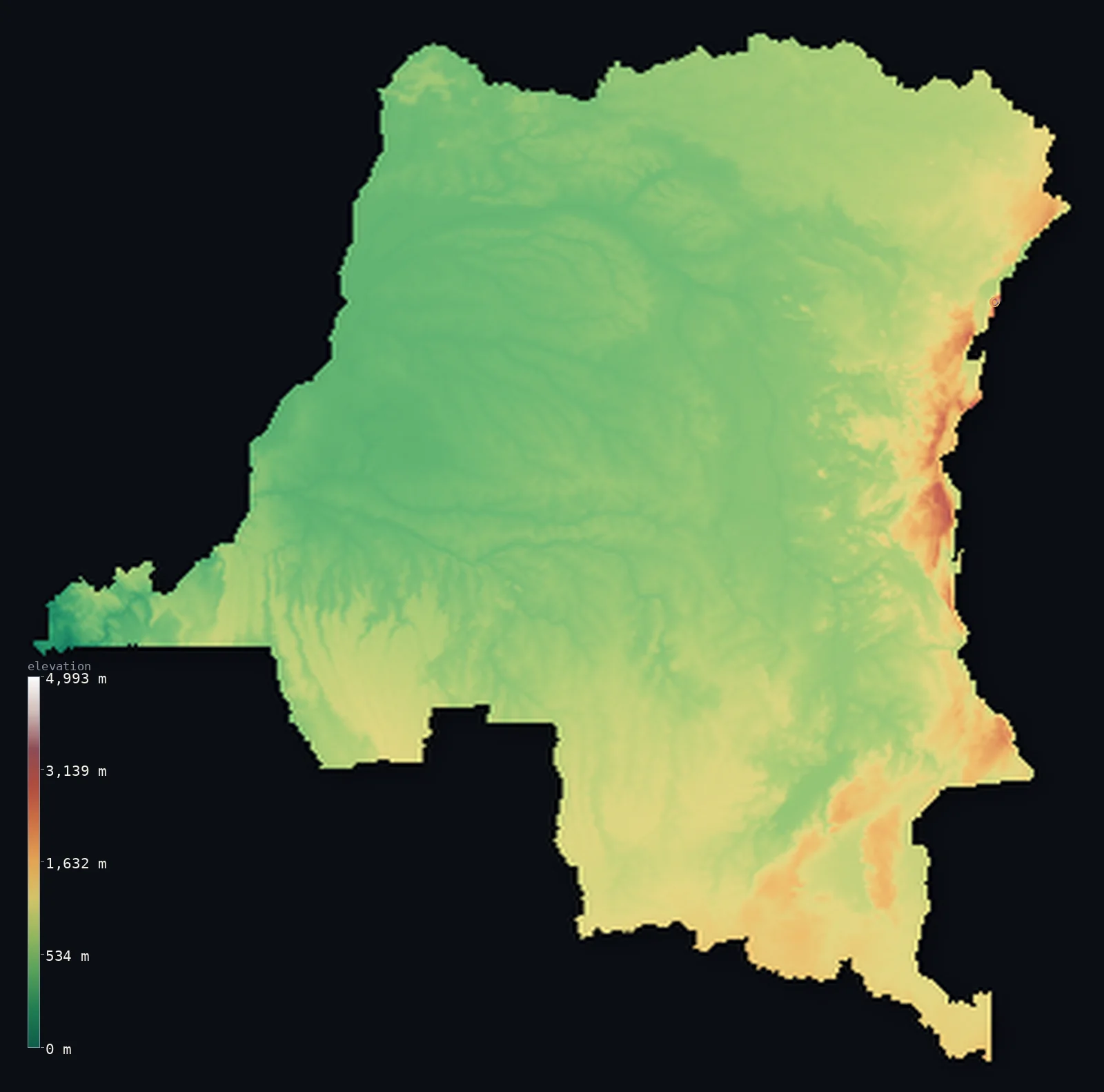
Democratic Republic of the Congo’s highest point is Margherita Peak (Mount Stanley) at 16,762 ft (5,109 m); its lowest is Atlantic Ocean at 0 ft (0 m); the mean elevation is 2,244 ft (684 m).
The Democratic Republic of the Congo is built around a vast basin. The second-largest country in Africa, it is filled at its heart by the Congo Basin — an immense, low, flat expanse of tropical rainforest, drained by the mighty Congo River, one of the largest rivers on Earth. Around this basin the land rises on every side to plateaus and highlands, climbing highest in the east along the Albertine Rift, where the Rwenzori Mountains reach Mount Stanley at 16,762 ft (5,109 m) and a chain of great volcanoes and lakes marks the border. A low green core within a high rim.
- Highest point📚
- 16,762 ft5,109 m
- The DRC's highest point is Mount Stanley (Margherita Peak) at 16,762 ft (5,109 m), in the Rwenzori Mountains on the eastern border with Uganda — a glaciated massif shared between the two countries, its summit standing on the frontier. The Rwenzori, the fabled 'Mountains of the Moon,' carry some of the only permanent ice in Africa, high above the rift lakes below. It is the roof of a country that is otherwise mostly low basin.
- Lowest point📚
- 0 ft0 m
- The DRC's lowest point is the Atlantic Ocean at sea level, reached along the country's very short coast in the far west, where the Congo River — after crossing the whole country — finally meets the sea.
- Mean elevation⚙
- 2,244 ft684 m
- Computed from the GLO-30 model, the DRC's mean elevation is 2,244 ft (684 m) — a moderate figure that averages two very different terrains: the vast low rainforest basin at the country's heart, and the high plateaus and rift mountains that ring it, climbing to over 5,000 m in the east.
- Median elevation⚙
- 1,919 ft585 m
- Half of the DRC lies below about 1,919 ft (585 m) — reflecting the dominance of the great central basin: the low, flat rainforest floor covers so much of the country that most of the DRC lies low, with the surrounding plateaus and the eastern rift mountains the higher minority.
- Elevation range📚
- 16,762 ft5,109 m
- From the Atlantic to the summit of Mount Stanley at 5,109 m, the DRC's terrain climbs about 16,760 ft — from a sea-level coast, up the low basin, to the glaciers of the Rwenzori on the eastern border, one of the widest ranges of any African country.
- Above 1,000 m (3,281 ft)⚙
- 16%
- About 16% of the DRC rises above 1,000 m (3,281 ft) — the plateaus and highlands that ring the central basin, especially the Katanga plateau of the south and the eastern rift highlands around the Rwenzori. The vast Congo Basin at the country's heart lies lower.
- Official area📚
- 905,354 mi²2,344,858 km²
- The DRC covers about 905,000 sq mi (2,344,858 sq km) — the second-largest country in Africa, filled by the vast low Congo Basin rainforest, ringed by plateaus and, in the east, the high mountains and volcanoes of the Albertine Rift.
- Forest cover📚
- 67.3%
- About 67% of the DRC is forested — the country holds the largest part of the Congo rainforest, the second-largest tropical rainforest on Earth after the Amazon, a vast expanse of dense forest across the central basin; the plateaus and highlands are more open savanna and montane country.
Highest and lowest points
The DRC's highest point is Mount Stanley, whose summit Margherita Peak reaches 16,762 ft (5,109 m), in the Rwenzori Mountains on the eastern border with Uganda. It is a glaciated massif — the Rwenzori, long known as the 'Mountains of the Moon,' hold some of the only permanent glaciers in Africa, though they are retreating fast. Margherita's summit stands on the frontier, and the peak is the highest point of both the DRC and Uganda. It rises in the Albertine Rift, the western branch of the Great Rift Valley, which runs down the country's eastern edge in a line of high mountains, volcanoes — including the lava-lake volcano Nyiragongo — and deep rift lakes. Far to the west and below, the great Congo Basin spreads out low and green: the DRC climbs from that basin to these eastern glaciers.
source ↗The DRC's lowest point is the Atlantic Ocean at sea level, along a very short coastline in the far west — a narrow corridor only about 37 km wide where the Congo River, having crossed the entire country and gathered the waters of the basin, reaches the sea. It is a striking outlet: this immense country, for all its size, touches the ocean along only a thin sliver of coast, through which one of the world's greatest rivers finally drains.
source ↗Democratic Republic of the Congo at a glance
The DR Congo's highest point, Margherita Peak (5,109 m), carries permanent glaciers despite sitting almost exactly on the Equator — and is the joint summit of both the DR Congo and Uganda.
source ↗It is the second-largest country in Africa, after Algeria — yet its Atlantic coastline is only about 37 km long, a tiny sliver at the mouth of the Congo River.
source ↗The Congo River crosses the Equator twice on its great arc across the country — the only major river in the world to do so.
source ↗Roughly two-thirds of the country is rainforest — the heart of the Congo Basin, the world's second-largest tropical forest after the Amazon.
source ↗The eastern border is a line of the East African Rift, holding both glaciated peaks (the Rwenzori) and active volcanoes (Nyiragongo, with one of the world's largest lava lakes, above the city of Goma).
source ↗Lake Tanganyika, forming much of the southeastern border, is the second-deepest lake on Earth — part of the chain of Great Lakes strung along the rift.
source ↗
Elevation profile of Democratic Republic of the Congo
The largest share of land, 47%, falls in the 500–1,000 m band, and 63% of the territory lies above 500 m (1,640 ft).
- below 500 m (1,640 ft)37%
- 500–1,000 m47%
- 1,000–2,000 m16%
- above 2,000 m (6,562 ft)1%
Highest peaks of Democratic Republic of the Congo
| Peak | Elevation | Range | Note |
|---|---|---|---|
| Margherita Peak (Mount Stanley)↗ | 16,762 ft5,109 m | Rwenzori Mountains | Highest point of the DR Congo (and Uganda), a glaciated peak on the Uganda border; third-highest in Africa. |
| Mount Karisimbi↗ | 14,787 ft4,507 m | Virunga Mountains | A dormant volcano on the Rwanda border, the highest of the Virunga chain. |
| Mount Mikeno↗ | 14,557 ft4,437 m | Virunga Mountains | A steep extinct volcano in the Virunga range within Virunga National Park, gorilla country. |
| Mount Nyiragongo↗ | 11,385 ft3,470 m | Virunga Mountains | An active volcano above Goma, holding one of the world's largest lava lakes. |
| Mitumba Mountains (high ground)↗ | 9,810 ft2,990 m | Mitumba (Western Rift escarpment) | The rift-edge ranges rising above Lakes Kivu and Tanganyika along the eastern border. |
DR Congo: the Congo Basin, the plateau rim, and the eastern rift
The Congo Basin (the heart)
The heart of the DRC is the Congo Basin — a vast, low, flat expanse of tropical rainforest, one of the largest in the world, drained by the Congo River and its many tributaries. Immense, low, and densely forested, it covers much of the country and defines it.
The plateaus and savannas (the rim)
Around the central basin the land rises to plateaus and savannas — the Katanga plateau of the mineral-rich south, the northern uplands, and the western highlands toward the coast. Higher, drier, and more open than the basin, they form the raised rim around the forested core.
The eastern rift and mountains
Along the eastern border runs the Albertine Rift — the western branch of the Great Rift Valley — a line of high mountains, volcanoes, and deep lakes. The glaciated Rwenzori (holding Mount Stanley), the Virunga volcanoes including Nyiragongo, and lakes like Kivu and Tanganyika mark the country's highest and most dramatic ground.
How to read this map
Color shows elevation; the raised relief shows real terrain. On this map the DRC reads as a low green bowl within a higher rim — the vast low basin of the Congo rainforest filling the centre in low tones, rising to the browns of the plateaus around it and, most sharply, to the high whites of the Rwenzori and the eastern rift mountains along the Uganda border.
The 3D relief is the actual GLO-30 elevation data, exaggerated vertically so the low basin and the high eastern rim both show; the ×N relief slider controls how much. Tap anywhere to read that point's exact elevation.
City elevations in Democratic Republic of the Congo
The DRC's cities ring and dot the basin — Kinshasa, the huge capital, on the Congo River in the west; Lubumbashi and Kolwezi high on the southern Katanga plateau; Kisangani and Mbandaka on the river in the northern basin; Bukavu on the eastern rift lakes; and Mbuji-Mayi, Kananga, Kikwit, and Tshikapa across the southern interior. Many sit on the rivers or the raised rim.
| City | Population | Elevation |
|---|---|---|
| Kinshasacapitalthe capital, on the Congo River in the west ↗ | 16,000,000 | 928 ft283 m |
| Lubumbashion the Katanga plateau in the southeast ↗ | 2,221,925 | 4,134 ft1,260 m |
| Mbuji-Mayiin the south-central interior ↗ | 2,101,332 | 2,034 ft620 m |
| Kanangain the south-central interior ↗ | 1,247,168 | 2,110 ft643 m |
| Kisanganion the Congo River in the northern basin, at the great bend ↗ | 1,181,788 | 1,293 ft394 m |
| Bukavuon Lake Kivu in the eastern rift ↗ | 816,811 | 5,246 ft1,599 m |
| Kolwezion the Katanga plateau, in the Copperbelt mining region ↗ | 790,248 | 4,862 ft1,482 m |
| Tshikapain the southwest, on the Kasai River ↗ | 634,529 | 1,581 ft482 m |
| Kikwitin the southwest, on the Kwilu River ↗ | 509,367 | 1,526 ft465 m |
| Mbandakaon the Congo River in the equatorial basin, near the equator ↗ | 455,011 | 1,027 ft313 m |
Elevation sampled at each city centre from the Copernicus GLO-30 model. Cities and population from GeoNames (CC-BY 4.0).
Democratic Republic of the Congo in comparison
Democratic Republic of the Congo's terrain rises 16,762 ft (5,109 m) from sea level to Margherita Peak (Mount Stanley) — about 58% of the height of Mount Everest, the world's highest point at 29,032 ft (8,849 m).
- Republic of the Congo's mean elevation is 1,371 ft — 873 ft lower; its high point, Mont Nabemba, reaches 3,346 ft (1,020 m), 13,415 ft below. Republic of the Congo elevation map →
- Uganda's mean elevation is 3,822 ft — 1,578 ft higher; its high point, Margherita Peak (Mount Stanley), reaches 16,762 ft (5,109 m), 0 ft above. Uganda elevation map →
- Angola's mean elevation is 3,402 ft — 1,158 ft higher; its high point, Mount Moco (Morro de Môco), reaches 8,596 ft (2,620 m), 8,166 ft below. Angola elevation map →
Frequently asked questions
What is the highest point in the DRC?
- Mount Stanley (Margherita Peak), 16,762 ft (5,109 m), in the Rwenzori Mountains on the Uganda border — a glaciated massif shared with Uganda, holding some of the only permanent ice in Africa.
What is the lowest point in the DRC?
- The Atlantic Ocean at sea level, along the country's tiny 37 km coast in the far west, where the Congo River reaches the sea.
What is the average elevation of the DRC?
- Computed from the Copernicus GLO-30 model, the area-weighted mean is 2,244 ft (684 m) — moderate, averaging the vast low Congo Basin at the country's heart against the high plateaus and rift mountains that ring it.
What are the Rwenzori Mountains?
- A glaciated range on the DRC-Uganda border, holding Mount Stanley, the highest point of both countries — the fabled 'Mountains of the Moon,' carrying some of the only permanent glaciers in Africa.
How big is the Congo Basin?
- It fills the heart of the DRC — a vast low rainforest, the second-largest tropical forest on Earth after the Amazon, drained by the Congo River across the whole country.
Is this a topographic, relief, contour, or elevation map of the DRC?
- They describe the same thing — terrain height. This page renders the country's actual elevation surface in interactive 3D and reports the statistics computed from it.
About this map
The terrain is rendered from the Copernicus GLO-30 digital elevation model (ESA), masked to the COD-ADM0 boundary from geoBoundaries (gbOpen). Elevation statistics are computed directly from the model; peak names and researched facts are sourced and cited. See the methodology for the full pipeline.
Our area-weighted mean, computed from the Copernicus GLO-30 model, is 2,244 ft (684 m); the figure commonly cited elsewhere is 2,382 ft (726 m) (CIA World Factbook). The DRC averages two very different terrains — the vast low Congo Basin at its heart and the high plateaus and rift mountains that ring it — giving a moderate area-weighted mean. The figure computed here from the Copernicus GLO-30 model is about 684 m; the CIA World Factbook cites 726 m.
Surveyed national figures: official area · forest cover · high point.
Rendered from Copernicus GLO-30 (ESA, 2021 release), boundaries from geoBoundaries. Generated 2026-06-22.
Bordering countries · 8
Democratic Republic of the Congo shares a land border with these countries — open any one to compare its terrain and highest point.
- Angola↑ Mount Moco (Morro de Môco), 2,620 m
- Burundi↑ Mount Heha, 2,684 m
- Central African Republic↑ Mont Ngaoui, 1,410 m
- Republic of the Congo↑ Mont Nabemba, 1,020 m
- Rwanda↑ Mount Karisimbi, 4,507 m
- South Sudan↑ Mount Kinyeti, 3,187 m
- Uganda↑ Margherita Peak (Mount Stanley), 5,109 m
- Zambia↑ Mafinga Central, 2,339 m