Republic of the Congo Elevation Map — Topographic & 3D Terrain
Explore the terrain of the Republic of the Congo in interactive 3D, built from Copernicus GLO-30 satellite elevation data — a low, forested Central African country of coastal plain, plateau, and the Congo basin. Drag to rotate, scroll to zoom, and tap any point to read its elevation.
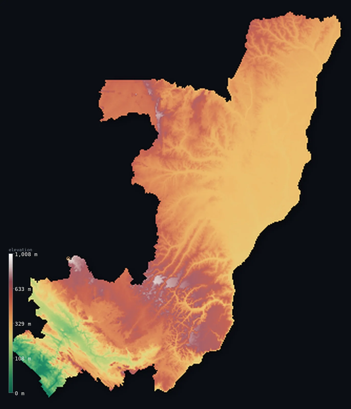
Republic of the Congo’s highest point is Mont Nabemba at 3,346 ft (1,020 m); its lowest is Atlantic Ocean at 0 ft (0 m); the mean elevation is 1,371 ft (418 m).
The Republic of the Congo is a low, heavily forested country of Central Africa, astride the Equator. Most of it lies low: a short Atlantic coast of lagoons and mangroves; the forested Mayombe and Chaillu hills of the south; the sandy Batéké Plateau of the centre; and, across the north, the vast, flat, marshy Congo basin — the Cuvette — of equatorial rainforest, part of the world's second-largest tropical forest. Its highest point, Mont Nabemba, an isolated northern dome, reaches only 3,346 ft (1,020 m), so half the country lies below about 1,310 ft and less than 1% above 1,000 m. Along the Congo River, the capital Brazzaville faces Kinshasa — the two closest capital cities in the world after Rome and the Vatican.
- Highest point📚
- 3,346 ft1,020 m
- The Republic of the Congo's highest point is Mont Nabemba at 3,346 ft (1,020 m), an isolated dome in the far-northwestern Sangha Department, about 50 km from Souanké. It rises abruptly from the flat Congo-basin lowlands and is the country's only ground to reach 1,000 m — Congo is otherwise a low land of forest and plateau. (Brazzaville's tallest building, the Nabemba Tower, is named after it.)
- Lowest point📚
- 0 ft0 m
- The Republic of the Congo's lowest point is the Atlantic Ocean at sea level, along a short, sandy coast of lagoons and mangroves in the southwest around Pointe-Noire. From this narrow coastal plain the land rises inland over the forested Mayombe hills to the plateaus and the vast Congo basin — but nowhere far: the Republic of the Congo is a low, forested country throughout.
- Mean elevation⚙
- 1,371 ft418 m
- Computed from the GLO-30 model, the Republic of the Congo's mean elevation is 1,371 ft (418 m) — low, for the country is mostly a land of coastal plain, plateau, and the flat, forested Congo basin. About half of it lies below about 1,309 ft (399 m), and the mean sits close by: Congo is low and even, with only the isolated dome of Mont Nabemba in the far north rising to any real height.
- Median elevation⚙
- 1,309 ft399 m
- Half of the Republic of the Congo lies below about 1,309 ft (399 m) — a low figure close to the mean, because the country is low throughout: a coastal plain, the forested Mayombe and Chaillu hills of the south, the sandy Batéké Plateau of the centre, and the vast, flat, marshy Congo basin (the Cuvette) of the north. Only Mont Nabemba rises well above, and it is a single dome.
- Elevation range📚
- 3,346 ft1,020 m
- From the Atlantic coast to Mont Nabemba at 1,020 m, the Republic of the Congo's terrain climbs about 3,346 ft — but the rise is gentle and confined to one northern dome: most of the country is low coastal plain, plateau, and forested basin, and less than 1% of it stands above 1,000 m.
- Above 1,000 m (3,281 ft)⚙
- 0%
- Less than 1% of the Republic of the Congo rises above 1,000 m (3,281 ft) — effectively only the isolated dome of Mont Nabemba in the far north. Nearly all of the country is low: coastal plain, the Batéké Plateau, and the vast forested Congo basin.
- Official area📚
- 132,047 mi²342,000 km²
- The Republic of the Congo covers about 132,047 sq mi (342,000 sq km) — a Central African country astride the Equator, of a short Atlantic coast and the forested Mayombe hills in the southwest, the fertile Niari Valley and Chaillu Massif of the south, the sandy Batéké Plateau of the centre, and the vast, flat Congo basin (the Cuvette) of the forested north.
- Forest cover📚
- 65.6%
- About 66% of the Republic of the Congo is forested — two-thirds of the country is rainforest, part of the Congo Basin, the world's second-largest tropical forest: the marshy Cuvette of the north, holding Nouabalé-Ndoki, one of the most intact forest reserves on Earth, and the Mayombe and Chaillu hills of the south.
Highest and lowest points
The highest point of the Republic of the Congo at 1,020 m, an isolated dome in the far-northwestern Sangha Department about 50 km from Souanké. It rises abruptly from the flat Congo-basin lowlands on the ancient Congo Craton; iron-ore deposits lie around it, and Brazzaville's Nabemba Tower is named after it.
source ↗The Republic of the Congo's lowest point is the Atlantic Ocean at sea level, along a short, sandy southwestern coast of lagoons and mangroves around the port of Pointe-Noire. Behind the coast the land rises over the forested Mayombe hills, then falls to the fertile Niari Valley and climbs again to the Chaillu Massif; across the centre runs the sandy Batéké Plateau, around 800 m, which divides the Ogooué and Congo drainages; and the whole north is the Cuvette — the vast, flat, marshy Congo basin of equatorial rainforest, part of the world's second-largest tropical forest and home to Nouabalé-Ndoki National Park. Mont Nabemba, an isolated dome in the far northwest, is the one point to reach 1,020 m. The Congo River forms much of the eastern and southern border — its rapids below Brazzaville forcing river traffic onto rail — and across it the capital, Brazzaville, faces Kinshasa, capital of the Democratic Republic of the Congo, the two closest capital cities in the world after Rome and the Vatican. So the Republic of the Congo is a low, green, riverine land, low and even from the coast to the forested basin.
source ↗Republic of the Congo at a glance
The Republic of the Congo is a low country — its highest point, Mont Nabemba, reaches only 1,020 m, an isolated dome rising from the flat northern forest.
source ↗Brazzaville and Kinshasa, facing each other across the Congo River, are the two closest capital cities in the world after Rome and the Vatican.
source ↗About two-thirds of the country is rainforest — part of the Congo Basin, the world's second-largest tropical forest and a vast carbon sink.
source ↗The Equator crosses the country near the town of Makoua, dividing its equatorial-forest north from its more tropical, savanna south.
source ↗The Congo River forms much of the country's eastern and southern border, and its rapids below Brazzaville force river traffic to transfer to rail for the trip to the coast at Pointe-Noire.
source ↗Brazzaville's tallest building, the Nabemba Tower, is named after the country's highest mountain.
source ↗The northern Cuvette holds Nouabalé-Ndoki National Park, one of the most intact tropical forest reserves on Earth and a stronghold of western lowland gorillas.
source ↗
Elevation profile of Republic of the Congo
The largest share of land, 39%, falls in the 300–400 m band, and 73% of the territory lies below 500 m (1,640 ft).
- below 500 m (1,640 ft)73%
- 500–1,000 m27%
Highest peaks of Republic of the Congo
| Peak | Elevation | Range | Note |
|---|---|---|---|
| Mont Nabemba↗ | 3,346 ft1,020 m | Sangha (northern Congo Craton) | Highest point of the Republic of the Congo, an isolated dome rising from the northern forest lowlands. |
| Chaillu Massif (high ground)↗ | 3,117 ft950 m | Chaillu Massif (southwest) | The forested crystalline massif of the southwest, shared with Gabon — among the country's highest relief outside Nabemba. |
| Batéké Plateau (high ground)↗ | 2,723 ft830 m | Batéké Plateau (centre) | The sandy central plateau separating the Ogooué and Congo river basins, rising to around 800 m. |
| Mayombe Mountains (high ground)↗ | 2,625 ft800 m | Mayombe (southwest) | A forested coastal range running parallel to the Atlantic, behind the coastal plain near the Gabon and Cabinda borders. |
| Southern hills (Pool/Bouenza)↗ | 2,297 ft700 m | southeastern hills | Rolling hill country in the south and southeast, of high grassland and scattered woodland. |
The Republic of the Congo: the coast and Mayombe, the plateaus and valleys, and the Congo basin
The coast and Mayombe (southwest)
A flat, sandy Atlantic coastal strip of lagoons and mangroves around Pointe-Noire, backed inland by the forested Mayombe hills.
The Niari Valley and Chaillu Massif (south)
The fertile alluvial Niari Valley of the south-centre and, above it, the forested Chaillu Massif — the higher, more broken country of the south.
The central Batéké Plateau
The sandy central plateau, around 800 m, of open savanna and gallery forest, dividing the Ogooué and Congo drainage basins.
The northern Congo basin (Cuvette)
The vast, low, flat northern Congo basin — the Cuvette — of marshy, often-flooded equatorial rainforest, holding Mont Nabemba and the Nouabalé-Ndoki reserve.
How to read this map
Color shows elevation; the raised relief shows real terrain. On this map the Republic of the Congo reads as a low, green country — a broad low-to-middle tone of coastal plain, plateau, and the vast forested Congo basin, rising a little to the Mayombe and Chaillu hills of the south and the Batéké Plateau of the centre, with the isolated dome of Mont Nabemba in the far north the one real height.
Because the country is largely low, the 3D exaggeration is what makes the southern hills and Nabemba stand out; the ×N relief slider controls how much. Tap anywhere to read that point's exact elevation.
City elevations in Republic of the Congo
The Republic of the Congo's two great cities anchor its ends — Brazzaville, the capital, on the Congo River facing Kinshasa, and Pointe-Noire, the Atlantic port — with smaller centres like Dolisie in the south and Ouesso and Impfondo in the forested north.
| City | Population | Elevation |
|---|---|---|
| Brazzavillecapitalthe capital, on the Congo River facing Kinshasa ↗ | 1,982,000 | 938 ft286 m |
| Pointe-Noirethe Atlantic port, on the southwest coast ↗ | 1,032,000 | 23 ft7 m |
| Dolisiein the south, in the Niari Valley ↗ | 121,000 | 1,089 ft332 m |
| Impfondoin the far northeast, in the Cuvette basin ↗ | 48,939 | 1,063 ft324 m |
| Ouessoin the forested north, in the Sangha ↗ | 40,667 | 1,142 ft348 m |
| Owandoin the north-central Cuvette ↗ | 35,698 | 1,148 ft350 m |
| Sibitiin the south, near the Chaillu Massif ↗ | 33,122 | 1,739 ft530 m |
| Loutété | 27,726 | 705 ft215 m |
| Gambomaon the central Batéké Plateau ↗ | 26,718 | 1,207 ft368 m |
| Mossaka | 21,809 | 945 ft288 m |
Elevation sampled at each city centre from the Copernicus GLO-30 model. Cities and population from GeoNames (CC-BY 4.0).
Republic of the Congo in comparison
Republic of the Congo's terrain rises 3,346 ft (1,020 m) from sea level to Mont Nabemba — about 12% of the height of Mount Everest, the world's highest point at 29,032 ft (8,849 m).
- Gabon's mean elevation is 1,243 ft — 128 ft lower; its high point, Mont Bengoue, reaches 3,510 ft (1,070 m), 164 ft above. Gabon elevation map →
- Democratic Republic of the Congo's mean elevation is 2,244 ft — 873 ft higher; its high point, Margherita Peak (Mount Stanley), reaches 16,762 ft (5,109 m), 13,415 ft above. Democratic Republic of the Congo elevation map →
- Cameroon's mean elevation is 2,126 ft — 755 ft higher; its high point, Fako (Mount Cameroon), reaches 13,435 ft (4,095 m), 10,089 ft above. Cameroon elevation map →
Frequently asked questions
What is the highest point in the Republic of the Congo?
- Mont Nabemba, 3,346 ft (1,020 m), an isolated dome in the far-northwestern Sangha Department - the country's only ground to reach 1,000 m.
What is the average elevation of the Republic of the Congo?
- Computed from the Copernicus GLO-30 model, the area-weighted mean is 1,371 ft (418 m) - low, because the country is mostly coastal plain, plateau, and the flat forested Congo basin. About half lies below about 1,309 ft (399 m).
Is the Republic of the Congo mountainous?
- No - it is a low, forested country of coastal plain, plateau, and the vast Congo basin. Only Mont Nabemba, an isolated northern dome, reaches 1,020 m; less than 1% of the country is above 1,000 m.
What is the lowest point in the Republic of the Congo?
- The Atlantic Ocean at sea level, along the short southwestern coast around Pointe-Noire.
How is it different from the Democratic Republic of the Congo?
- They are separate countries facing each other across the Congo River: the Republic of the Congo (capital Brazzaville) is the smaller country on the northwest bank; the Democratic Republic of the Congo (capital Kinshasa) is the far larger country to the southeast. Brazzaville and Kinshasa face each other across the river.
What river dominates the Republic of the Congo?
- The Congo River, which forms much of the eastern and southern border and drains the country's vast forested basin; its rapids below Brazzaville force river traffic to transfer to rail.
Is this a topographic, relief, contour, or elevation map of the Republic of the Congo?
- They describe the same thing - terrain height. This page renders the country's actual elevation surface in interactive 3D and reports the statistics computed from it.
About this map
The terrain is rendered from the Copernicus GLO-30 digital elevation model (ESA), masked to the COG-ADM0 boundary from geoBoundaries (gbOpen). Elevation statistics are computed directly from the model; peak names and researched facts are sourced and cited. See the methodology for the full pipeline.
Our area-weighted mean, computed from the Copernicus GLO-30 model, is 1,371 ft (418 m); the figure commonly cited elsewhere is 1,411 ft (430 m) (CIA World Factbook). The Republic of the Congo is a low, heavily forested country astride the Equator, its highest ground a single isolated dome. Most of it lies low: a short Atlantic coastal plain of lagoons and mangroves; the forested Mayombe and Chaillu hills and the fertile Niari Valley of the south; the sandy Batéké Plateau of the centre; and, across the north, the vast, flat, marshy Congo basin — the Cuvette — of equatorial rainforest, part of the second-largest tropical forest on Earth. Only Mont Nabemba, in the far northwest, rises to 1,020 m. So the mean and median are close and both low; half the country lies below about 1,309 ft (399 m), and less than a hundredth of it reaches 1,000 m. The Congo River forms much of the eastern and southern border, and on it Brazzaville faces Kinshasa across the water — the two closest capital cities in the world after Rome and the Vatican.
Surveyed national figures: official area · forest cover · high point.
Rendered from Copernicus GLO-30 (ESA, 2021 release), boundaries from geoBoundaries. Generated 2026-06-22.
Bordering countries · 5
Republic of the Congo shares a land border with these countries — open any one to compare its terrain and highest point.