Gabon Elevation Map — Topographic & 3D Terrain
Explore the terrain of Gabon in interactive 3D, built from Copernicus GLO-30 satellite elevation data — a low, forested equatorial country on the Atlantic, drained by the Ogooué. Drag to rotate, scroll to zoom, and tap any point to read its elevation.
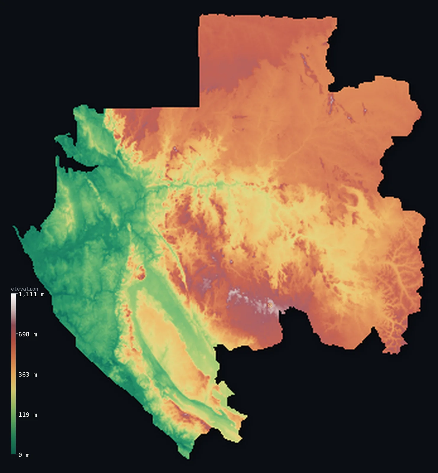
Gabon’s highest point is Mont Bengoue at 3,510 ft (1,070 m); its lowest is Atlantic Ocean at 0 ft (0 m); the mean elevation is 1,243 ft (379 m).
Gabon is a low, densely forested country straddling the equator on the Atlantic coast of Central Africa. Rainforest covers almost the whole country — part of the great Congo Basin forest — from a low coastal plain of lagoons and estuaries, across a broad interior of hills and plateaus drained by the Ogooué River and its tributaries. The land is mostly low and rolling, rising to modest highlands in the interior: the Chaillu Massif in the south-centre and other ranges, reaching the country's highest point, Mont Bengoué, at about 3,510 ft (1,070 m). Nearly nine-tenths forest, Gabon is one of the most heavily wooded countries on Earth.
- Highest point📚
- 3,510 ft1,070 m
- Gabon's highest point is Mont Bengoué at about 3,510 ft (1,070 m), a forested summit in the northeast of the interior — the highest of the modest highland masses that rise from Gabon's forested plateau. (The country's high ground is disputed in some sources, but the terrain model, like the dossier, puts Bengoué highest.) It rises above a country that is otherwise mostly low, rolling rainforest.
- Lowest point📚
- 0 ft0 m
- Gabon's lowest point is the Atlantic Ocean at sea level, along the equatorial coast in the west — a low, wet shore of lagoons, estuaries, and mangroves, where the Ogooué River reaches the sea through a broad delta.
- Mean elevation⚙
- 1,243 ft379 m
- Computed from the GLO-30 model, Gabon's mean elevation is 1,243 ft (379 m) — a low average for a low country: the coastal plain and the broad Ogooué basins lie near sea level across the west and centre, and even the forested interior rises only moderately, so nothing pulls the figure high.
- Median elevation⚙
- 1,421 ft433 m
- Half of Gabon lies above about 1,421 ft (433 m) — a median that lands higher than the mean, an inversion driven by the coast: the sea-level shore and the Ogooué floodplains sink the average, while the typical Gabonese point is an interior hill some way above it. The low coast, not the high interior, is what pulls the average down.
- Elevation range📚
- 3,510 ft1,070 m
- From the Atlantic to the summit of Mont Bengoué at about 1,070 m, Gabon's terrain spans about 3,510 ft — little more than a kilometre of vertical relief across the whole country. Bengoué barely clears 1,000 m, and behind the coast the land only rolls gently up through forested hills to the modest interior massifs.
- Above 1,000 m (3,281 ft)⚙
- <1%
- Barely any of Gabon rises above 1,000 m (<1%) — only the very tops of the interior massifs, like the Chaillu. About 40% of the country clears 500 m (1,640 ft) — the interior hills and modest highlands — while the low coastal plain in the west and the broad Ogooué river basins lie lower.
- Official area📚
- 103,347 mi²267,667 km²
- Gabon covers about 103,300 sq mi (267,667 sq km) — a low, heavily forested country on the equatorial Atlantic coast of Central Africa, mostly rainforest lowland and rolling hill country drained by the Ogooué River, rising to modest interior highlands like the Chaillu Massif.
- Forest cover📚
- 90%
- About 90% of Gabon is forested — one of the most heavily forested countries on Earth, with dense equatorial rainforest, part of the Congo Basin forest, covering almost the entire country, from the coastal lowlands across the interior hills, sheltering forest elephants, gorillas, and much of Central Africa's wildlife.
Highest and lowest points
Gabon's highest point is Mont Bengoué, at about 3,510 ft (1,070 m), a forested summit in the northeastern interior of the country. It is the highest of the several modest highland masses that rise from Gabon's forested plateau — among them the Chaillu Massif in the south-centre, the Cristal Mountains in the northwest near the coast, and the Du Chaillu and Bengoué highlands of the interior. (Gabon's highest point is given differently in some sources, with a few citing higher figures for other summits, but both the dossier and the GLO-30 terrain model make Mont Bengoué the highest.) None of these are great mountains: Gabon is essentially a low, forested country whose highlands are modest rises above the rainforest. Bengoué holds the title less by height than by correction — it stands as the true summit only because the long-quoted 1,575 m figure for Mont Iboundji, in the southern Chaillu Massif, proved unsupported by satellite data and was set aside.
source ↗Gabon's lowest point is the Atlantic Ocean at sea level, along a low, wet equatorial coast of lagoons, sandy bars, estuaries, and mangroves. The country's great river, the Ogooué, reaches the sea here through a broad delta near Port-Gentil, after draining most of Gabon: it and its tributaries gather the waters of the interior forests and carry them west to the Atlantic. Behind the coastal plain the land rises gently into the vast forested interior — a rolling country of hills and low plateaus, almost entirely rainforest — with modest highlands rising here and there, but no high mountains. Gabon straddles the equator, and its dense forests are among the least disturbed in Africa.
source ↗Gabon at a glance
Gabon's highest point isn't the famous Mont Iboundji - the long-quoted 1,575 m figure for Iboundji isn't supported by satellite (SRTM) data, and Mont Bengoue (1,070 m) in the northeast is the real summit.
source ↗Around 90% of Gabon is forest, making it one of the most heavily forested countries on Earth - much of it intact equatorial rainforest.
source ↗Almost the entire country drains into a single river system - the Ogooue and its tributaries cover the eastern two-thirds of Gabon.
source ↗The Equator runs straight across Gabon, yet its great forest cover keeps much of the country cooler and wetter than the bare tropics.
source ↗Gabon's coast is a maze of estuaries, lagoons and mangroves, with Cape Lopez marking the westernmost point near the Ogooue delta.
source ↗Despite straddling the Equator, most of Gabon's relief is gentle - rolling forested plateaus rather than high mountains, the tallest barely passing 1,000 m.
source ↗
Elevation profile of Gabon
The largest share of land, 26%, falls in the 500–600 m band, and 60% of the territory lies below 500 m (1,640 ft).
- below 500 m (1,640 ft)60%
- 500–1,000 m40%
- 1,000–2,000 m<1%
Highest peaks of Gabon
| Peak | Elevation | Range | Note |
|---|---|---|---|
| Mont Bengoue↗ | 3,510 ft1,070 m | northeastern Gabon (Ogooue-Ivindo) | Highest point of Gabon, in the forested northeast. |
| Mont Iboundji↗ | 3,215 ft980 m | Chaillu Massif (south) | A peak of the southern Chaillu Massif, long but wrongly cited as Gabon's highest at 1,575 m. |
| Bateke Plateau↗ | 2,723 ft830 m | southeastern Gabon | The high sandy plateau of the southeast, on the border with the Republic of the Congo. |
Gabon: the Atlantic coastal lowlands, the Ogooué basin and interior forests, and the modest highlands
The coastal plain
Gabon's Atlantic coast is low and wet — a plain of lagoons, sandbars, estuaries, and mangroves, broad in the north and narrower in the south, where the Ogooué reaches the sea through a delta. The country's low, forested seaward edge, holding Libreville and Port-Gentil.
The interior forests and river basins
Most of Gabon is a vast interior of rolling forested hills and low plateaus — dense rainforest drained by the Ogooué and its many tributaries, the great basin that covers the heart of the country. Low, green, and almost entirely wooded, it is the essential Gabon.
The interior highlands
Modest highlands rise from the forested interior — the Chaillu Massif in the south-centre, the Cristal Mountains inland of the northwest coast, and the Bengoué highlands (with the high point) in the northeast. Forested, rounded, and moderate in height, they are the country's higher, but never mountainous, ground.
How to read this map
Color shows elevation; the raised relief shows real terrain. On this map Gabon reads as a low, forested country of gentle relief — low greens along the Atlantic coast and across the broad Ogooué basins, rising to the mid-toned rolling hill country and modest highlands of the interior (the Chaillu Massif, the Cristal Mountains, and the Bengoué highlands with the high point), none of it rising very high.
The 3D relief is the actual GLO-30 elevation data, exaggerated vertically so the gentle differences show; the ×N relief slider controls how much. Tap anywhere to read that point's exact elevation.
City elevations in Gabon
Gabon's cities cluster on the coast and along the Ogooué — Libreville, the capital, on the Atlantic coast in the northwest, Port-Gentil at the Ogooué delta, Lambaréné on the river, and Franceville and Oyem in the interior. Most of the largest lie on the coast or the great river.
| City | Population | Elevation |
|---|---|---|
| Librevillecapitalthe capital, on the Atlantic coast in the northwest ↗ | 846,090 | 23 ft7 m |
| Port-Gentilthe main port, on the coast at the Ogooué delta ↗ | 164,018 | 10 ft3 m |
| Francevillein the southeastern interior, on the upper Ogooué ↗ | 132,895 | 1,325 ft404 m |
| Oyemin the far northern interior ↗ | 72,939 | 2,175 ft663 m |
| Lambarénéon the Ogooué River in the interior ↗ | 46,605 | 66 ft20 m |
| Mouilain the southern interior ↗ | 43,342 | 292 ft89 m |
| Tchibangain the far south ↗ | 36,108 | 161 ft49 m |
| Koulamoutouin the southeastern interior ↗ | 30,830 | 922 ft281 m |
| Oyamin the west-central interior ↗ | 30,100 | 289 ft88 m |
Elevation sampled at each city centre from the Copernicus GLO-30 model. Cities and population from GeoNames (CC-BY 4.0).
Gabon in comparison
Gabon's terrain rises 3,510 ft (1,070 m) from sea level to Mont Bengoue — about 12% of the height of Mount Everest, the world's highest point at 29,032 ft (8,849 m).
- Cameroon's mean elevation is 2,126 ft — 883 ft higher; its high point, Fako (Mount Cameroon), reaches 13,435 ft (4,095 m), 9,925 ft above. Cameroon elevation map →
- Central African Republic's mean elevation is 1,962 ft — 719 ft higher; its high point, Mont Ngaoui, reaches 4,626 ft (1,410 m), 1,115 ft above. Central African Republic elevation map →
- Democratic Republic of the Congo's mean elevation is 2,244 ft — 1,001 ft higher; its high point, Margherita Peak (Mount Stanley), reaches 16,762 ft (5,109 m), 13,251 ft above. Democratic Republic of the Congo elevation map →
Frequently asked questions
What is the highest point in Gabon?
- Mont Bengoué, about 3,510 ft (1,070 m), a forested summit in the northeastern interior — the highest of Gabon's modest highlands, though the country has no great mountains.
Isn't Mont Iboundji the highest point in Gabon?
- It is often claimed to be, at 1,575 m, but that figure isn't supported by satellite data — Iboundji is nearer 980 m, so Mont Bengoué (1,070 m) is Gabon's actual high point.
What is the lowest point in Gabon?
- The Atlantic Ocean at sea level, along the low, wet equatorial coast, where the Ogooué River reaches the sea through a delta.
What is the average elevation of Gabon?
- Computed from the Copernicus GLO-30 model, the area-weighted mean is 1,243 ft (379 m) — low, because Gabon is mostly low, forested lowland and rolling hill country, with only modest interior highlands rising above.
How forested is Gabon?
- One of the most heavily forested countries on Earth — dense equatorial rainforest, part of the Congo Basin forest, covers nearly the whole country, sheltering forest elephants, gorillas, and much of Central Africa's wildlife.
What is the Ogooué River?
- Gabon's great river — draining most of the country's interior forests westward through a broad delta to the Atlantic, the artery of a low, forested land.
Is this a topographic, relief, contour, or elevation map of Gabon?
- They describe the same thing — terrain height. This page renders the country's actual elevation surface in interactive 3D and reports the statistics computed from it.
About this map
The terrain is rendered from the Copernicus GLO-30 digital elevation model (ESA), masked to the GAB-ADM0 boundary from geoBoundaries (gbOpen). Elevation statistics are computed directly from the model; peak names and researched facts are sourced and cited. See the methodology for the full pipeline.
Our area-weighted mean, computed from the Copernicus GLO-30 model, is 1,243 ft (379 m); no authority publishes a mean elevation (the CIA World Factbook). Gabon is almost entirely low equatorial rainforest in the Ogooué basin, rising only to modest interior plateaus and hills, so no single mean is widely published; the area-weighted value computed here from GLO-30 is low, weighed down by the sea-level coast and the vast river basins that cover most of the country.
Surveyed national figures: official area · forest cover · high point.
Rendered from Copernicus GLO-30 (ESA, 2021 release), boundaries from geoBoundaries. Generated 2026-06-23.
Bordering countries · 3
Gabon shares a land border with these countries — open any one to compare its terrain and highest point.