Central African Republic Elevation Map — Topographic & 3D Terrain
Explore the terrain of the Central African Republic in interactive 3D, built from Copernicus GLO-30 satellite elevation data — a landlocked plateau at the watershed of Africa, between forest and savanna. Drag to rotate, scroll to zoom, and tap any point to read its elevation.
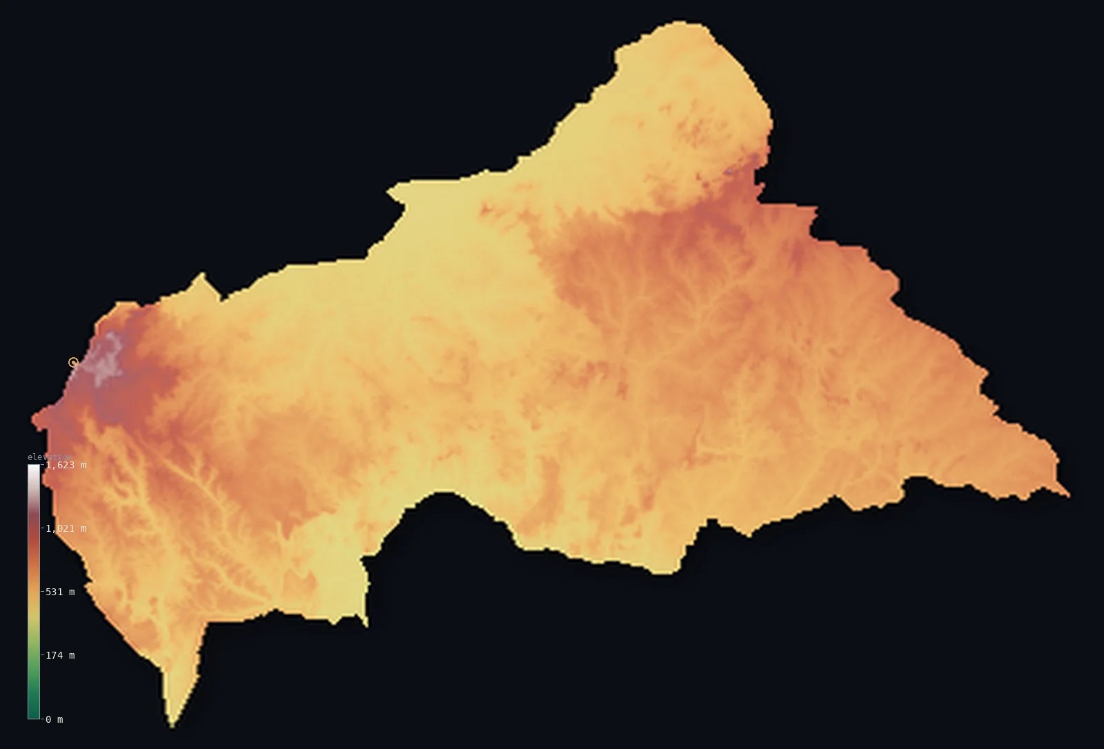
Central African Republic’s highest point is Mont Ngaoui at 4,626 ft (1,410 m); its lowest is Ubangi (Oubangui) River at 1,099 ft (335 m); the mean elevation is 1,962 ft (598 m).
The Central African Republic is a broad, rolling plateau at the heart of the continent. Landlocked and remote, most of it is gently undulating tableland, lying mostly between about 1,300 and 2,600 ft, forming a great divide: its rivers run south to the Congo and north to Lake Chad, and the plateau separates the two basins. The land shades from dense equatorial rainforest in the wetter south to open wooded savanna across the north. Higher ground rises on the margins — the Bongo Massif in the east, and, in the northwest on the Cameroon border, the country's highest point, Mont Ngaoui, at 4,626 ft (1,410 m).
- Highest point📚
- 4,626 ft1,410 m
- The Central African Republic's highest point is Mont Ngaoui at 4,626 ft (1,410 m), in the far northwest on the border with Cameroon — the highest of the modest highlands that rise from the country's plateau, on the approaches to the Adamawa highlands of Cameroon. In a country that is otherwise rolling tableland, it stands out as its highest ground, though it is no great peak.
- Lowest point📚
- 1,099 ft335 m
- The Central African Republic's lowest point is on the Ubangi River in the far south at about 1,099 ft (335 m) — where the great tributary of the Congo forms the country's southern border, the low outlet of a plateau that drains southward to the Congo basin.
- Mean elevation⚙
- 1,962 ft598 m
- Computed from the GLO-30 model, the Central African Republic's mean elevation is 1,962 ft (598 m) — a moderate figure, reflecting a country that is mostly a broad, gently rolling plateau: tableland of forest and savanna covers nearly all of it, at middling heights, with only the marginal highlands and the river valleys standing apart.
- Median elevation⚙
- 1,926 ft587 m
- Half of the Central African Republic lies below about 1,926 ft (587 m) — a figure close to the mean, because the country is so consistently a plateau: most of it is rolling tableland at much the same middling height, with only the eastern and northwestern highlands rising above and the southern river valleys below.
- Elevation range📚
- 3,527 ft1,075 m
- From the Ubangi River to the summit of Mont Ngaoui at 1,410 m, the Central African Republic's terrain spans about 3,530 ft — a modest range, since the country is mostly a rolling plateau of middling height, its highest ground the marginal highlands rather than any true mountains.
- Above 1,000 m (3,281 ft)⚙
- 2%
- About 2% of the Central African Republic rises above 1,000 m (3,281 ft) — only the marginal highlands: the Karré (Yadé) Massif with Mont Ngaoui in the northwest, and the Bongo Massif in the northeast. Most of the country — about 72% — lies above 500 m (1,640 ft), since it is a plateau of generally middling height; the lower ground follows the southern rivers toward the Congo.
- Official area📚
- 240,535 mi²622,984 km²
- The Central African Republic covers about 240,500 sq mi (622,984 sq km) — a landlocked country at the heart of Africa, a broad rolling plateau forming the divide between the Congo and Lake Chad basins, shading from southern rainforest to northern savanna, with marginal highlands and Mont Ngaoui in the northwest.
- Forest cover📚
- 35.6%
- About 36% of the Central African Republic is forested — dense equatorial rainforest across the wetter south (part of the Congo Basin forest), giving way to wooded savanna and grassland across the drier centre and north, the great climatic divide of the country.
Highest and lowest points
The Central African Republic's highest point is Mont Ngaoui, 4,626 ft (1,410 m), in the far northwest on the border with Cameroon. It rises on the eastern approaches to Cameroon's Adamawa highlands, the highest of the modest highland margins that flank the country's plateau. Though it stands on the Cameroonian border, it is not Cameroon's highest point — Cameroon's terrain climbs far higher, to Mount Cameroon, well to the west — but it is the summit of the CAR. Elsewhere the country's higher ground rises on its margins: the Bongo Massif and the Fertit Hills in the east, the Karré Mountains in the west. None are great mountains; the CAR is essentially a rolling plateau, and Mont Ngaoui is simply its highest corner.
source ↗The Central African Republic's lowest point is on the Ubangi River in the far south, at about 1,099 ft (335 m) above sea level — where the Ubangi, a major tributary of the Congo, forms the southern border with the Democratic Republic of the Congo. The country is a great watershed: its central plateau divides the waters of the continent, sending rivers south to the Ubangi and the Congo, and north to the Chari and Lake Chad. Landlocked and far from any sea, the CAR drains two ways from this high tableland — most of it southward to the Congo, the drier north toward Lake Chad — a divide at the heart of Africa.
source ↗Central African Republic at a glance
The Central African Republic is essentially one vast plateau that forms a continental watershed — its southern rivers drain to the Congo and the Atlantic, its northern rivers to Lake Chad.
source ↗Because it is landlocked and high, the country's lowest point is the Ubangi River at about 335 m — there is no land near sea level anywhere in the CAR.
source ↗The highest point, Mont Ngaoui (1,410 m), sits exactly on the Cameroon border — the 1908 colonial treaty defined the frontier as the watershed, which runs over the summit.
source ↗The plateau is dotted with kaga — isolated granite peaks and inselbergs that rise abruptly from the grassland, like rocky islands above a sea of savanna.
source ↗The CAR's old colonial name, Ubangi-Shari, came from its two defining rivers — the Ubangi in the south and the Chari (Shari) in the north.
source ↗Rainfall rises steadily from north to south — from about 760 mm a year in the dry northeast to over 1,780 mm in the rainforest southwest.
source ↗The Karré Mountains once sheltered Africans resisting French colonial rule, using the granite hills and boulders as natural defences.
source ↗
Elevation profile of Central African Republic
The largest share of land, 27%, falls in the 600–700 m band, and 72% of the territory lies above 500 m (1,640 ft).
- below 500 m (1,640 ft)28%
- 500–1,000 m71%
- 1,000–2,000 m2%
Highest peaks of Central African Republic
| Peak | Elevation | Range | Note |
|---|---|---|---|
| Mont Ngaoui↗ | 4,626 ft1,410 m | Karré Mountains (Yadé Massif) | Highest point of the Central African Republic, on the Cameroon border where the watershed defines the frontier. |
| Bongo Massif high point↗ | 4,488 ft1,368 m | Bongo Massif (northeast) | The high ground of the Bongo Mountains near the Sudan border, the country's other main upland, extending into Sudan. |
| Karré Mountains ridge↗ | 3,937 ft1,200 m | Karré Mountains (Yadé Massif) | The granite ridge of the Karré (Yadé) Massif around Bouar and Bocaranga, a continuation of Cameroon's Adamawa Plateau. |
| Fertit Hills↗ | 2,953 ft900 m | northeastern hills | Low hill country in the dry northeast toward the Sudan and South Sudan borders. |
| Central plateau kaga (inselbergs)↗ | 2,461 ft750 m | central plateau | Isolated granite peaks — called kaga — rising abruptly from the grassy central plateau across the country. |
The Central African Republic: the central plateau divide, forest and savanna, and the marginal highlands
The central plateau (the divide)
Most of the Central African Republic is a broad, gently rolling plateau — tableland of middling height forming the watershed of the continent, its rivers running south to the Congo and north to Lake Chad. Consistent, remote, and covering nearly the whole country, it is the CAR's essential form.
The southern forest and the northern savanna
The plateau shades climatically across the country — dense equatorial rainforest in the wetter south, part of the Congo Basin forest, giving way to open wooded savanna and grassland across the drier centre and north. The great forest-to-savanna divide of the CAR.
The marginal highlands
Higher ground rises on the country's edges — the Bongo Massif and Fertit Hills in the east, the Karré Mountains and Mont Ngaoui (the high point) in the northwest toward Cameroon. Modest highland margins flanking the great central plateau.
How to read this map
Color shows elevation; the raised relief shows real terrain. On this map the Central African Republic reads as a broad, even plateau — a wide expanse of middling tone covering nearly all of it (the rolling tableland), with slightly higher browns on the margins (the Bongo Massif in the east, the highlands toward Cameroon and Mont Ngaoui in the northwest) and the lower river valleys along the southern Ubangi.
The 3D relief is the actual GLO-30 elevation data, exaggerated vertically so the gentle plateau and its margins show; the ×N relief slider controls how much. Tap anywhere to read that point's exact elevation.
City elevations in Central African Republic
The Central African Republic's towns lie mostly in the south and centre — Bangui, the capital, on the Ubangi River at the southern border, Bambari and Bria in the interior, Bouar in the west toward Cameroon, and Bangassou on the Mbomou in the far southeast. Most sit on the plateau or along the southern rivers.
| City | Population | Elevation |
|---|---|---|
| Banguicapitalthe capital, on the Ubangi River at the southern border ↗ | 812,407 | 1,138 ft347 m |
| Carnotin the southwest ↗ | 129,032 | 1,818 ft554 m |
| Bambariin the centre ↗ | 83,029 | 1,516 ft462 m |
| Bouarin the west, in the Karré Mountains toward Cameroon ↗ | 71,680 | 3,176 ft968 m |
| Bossangoain the northwest ↗ | 55,353 | 1,509 ft460 m |
| Kaga-Bandoroin the north-centre of the plateau ↗ | 55,047 | 1,358 ft414 m |
| Bangassouin the far southeast, on the Mbomou River ↗ | 54,059 | 1,637 ft499 m |
| Paouain the far northwest, toward the Chad border ↗ | 47,703 | 1,975 ft602 m |
| Briain the east ↗ | 47,226 | 1,860 ft567 m |
| Kouangoin the south-centre, near the Ubangi ↗ | 36,575 | 1,194 ft364 m |
Elevation sampled at each city centre from the Copernicus GLO-30 model. Cities and population from GeoNames (CC-BY 4.0).
Central African Republic in comparison
Central African Republic's terrain rises 3,527 ft (1,075 m) from Ubangi (Oubangui) River (1,099 ft (335 m)) to Mont Ngaoui — about 12% of the height of Mount Everest, the world's highest point at 29,032 ft (8,849 m).
- Cameroon's mean elevation is 2,126 ft — 164 ft higher; its high point, Fako (Mount Cameroon), reaches 13,435 ft (4,095 m), 8,809 ft above. Cameroon elevation map →
- Chad's mean elevation is 1,696 ft — 266 ft lower; its high point, Emi Koussi, reaches 11,204 ft (3,415 m), 6,578 ft above. Chad elevation map →
- Democratic Republic of the Congo's mean elevation is 2,244 ft — 282 ft higher; its high point, Margherita Peak (Mount Stanley), reaches 16,762 ft (5,109 m), 12,136 ft above. Democratic Republic of the Congo elevation map →
- South Sudan's mean elevation is 1,686 ft — 276 ft lower; its high point, Mount Kinyeti, reaches 10,456 ft (3,187 m), 5,830 ft above. South Sudan elevation map →
Frequently asked questions
What is the highest point in the Central African Republic?
- Mont Ngaoui, 4,626 ft (1,410 m), in the far northwest on the Cameroon border — the highest of the country's modest highland margins, though not a great peak.
What is the lowest point in the Central African Republic?
- On the Ubangi River in the far south, at about 1,099 ft (335 m), where the great Congo tributary forms the southern border.
What is the average elevation of the Central African Republic?
- Computed from the Copernicus GLO-30 model, the area-weighted mean is 1,962 ft (598 m) — moderate, because the country is mostly a broad rolling plateau of middling height, with only marginal highlands and river valleys apart.
Is the Central African Republic mountainous?
- Mostly not — it is a broad rolling plateau, with modest highlands only on its margins (Mont Ngaoui, 1,410 m, in the northwest, and the Bongo Massif in the east). The plateau forms the divide between the Congo and Lake Chad basins.
What rivers are in the Central African Republic?
- The plateau divides the continent's waters — the Ubangi (a Congo tributary) and its feeders drain the south toward the Congo, while northern rivers like the Chari flow toward Lake Chad.
Is this a topographic, relief, contour, or elevation map of the Central African Republic?
- They describe the same thing — terrain height. This page renders the country's actual elevation surface in interactive 3D and reports the statistics computed from it.
About this map
The terrain is rendered from the Copernicus GLO-30 digital elevation model (ESA), masked to the CAF-ADM0 boundary from geoBoundaries (gbOpen). Elevation statistics are computed directly from the model; peak names and researched facts are sourced and cited. See the methodology for the full pipeline.
Our area-weighted mean, computed from the Copernicus GLO-30 model, is 1,962 ft (598 m); the figure commonly cited elsewhere is 2,083 ft (635 m) (CIA World Factbook). The Central African Republic is a broad, gently undulating plateau of middling height, rising to modest mountains only on its northwestern (Karré) and northeastern (Bongo) rims; the relief is low, and the computed mean runs a little below the commonly cited figure because the plateau is cut by the low valleys of the Ubangi and the Chari.
Surveyed national figures: official area · forest cover · high point.
Rendered from Copernicus GLO-30 (ESA, 2021 release), boundaries from geoBoundaries. Generated 2026-06-22.
Bordering countries · 6
Central African Republic shares a land border with these countries — open any one to compare its terrain and highest point.