Chad Elevation Map — Topographic & 3D Terrain
Explore the terrain of Chad in interactive 3D, built from Copernicus GLO-30 satellite elevation data — a vast landlocked country from the low Lake Chad basin to the high volcanoes of the Saharan Tibesti. Drag to rotate, scroll to zoom, and tap any point to read its elevation.
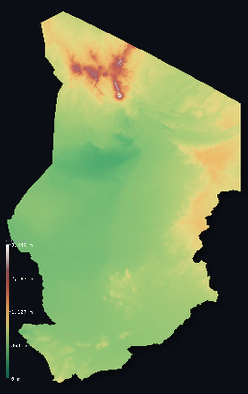
Chad’s highest point is Emi Koussi at 11,204 ft (3,415 m); its lowest is Djourab Depression at 525 ft (160 m); the mean elevation is 1,696 ft (517 m).
Chad is a vast, mostly dry country reaching from the Sahel deep into the Sahara. At its heart, and lowest, lies a broad basin — the Bodélé and the plains around Lake Chad in the west and south, a low interior sink into which the country's rivers drain. From this basin the land rises outward to higher rims: south to savanna and the Ouaddaï highlands in the east, and, most dramatically, north into the Sahara and the Tibesti Mountains — a great volcanic massif holding Emi Koussi at 11,204 ft (3,415 m), the highest point in the entire Sahara. Between the low basin and the high desert peaks, Chad spans one of the widest ranges of any country in the region.
- Highest point📚
- 11,204 ft3,415 m
- Chad's highest point is Emi Koussi at 11,204 ft (3,415 m), a huge extinct volcano at the southern end of the Tibesti Mountains in the far north — and the highest point in the whole Sahara Desert. A vast pyroclastic shield crowned with nested calderas, it rises from the desert plains in the far north of the country, the summit of a volcanic massif that is one of the most remote and dramatic landscapes in Africa. Nothing else in Chad, or anywhere in the Sahara, stands higher.
- Lowest point📚
- 525 ft160 m
- Chad's lowest point is in the Djourab Depression — the Bodélé — at about 525 ft (160 m), a low interior sink in the north-centre of the country. It is the dry heart of the old Lake Chad basin, once part of a far vaster lake, and today one of the greatest sources of dust on Earth, its sediments blown across the Atlantic.
- Mean elevation⚙
- 1,696 ft517 m
- Computed from the GLO-30 model, Chad's mean elevation is 1,696 ft (517 m) — a figure that hides two opposite countries averaged together: the low sink of the Lake Chad basin and the Bodélé, and the high Saharan volcanoes of the Tibesti, with broad savanna and desert plains stretched between them.
- Median elevation⚙
- 1,375 ft419 m
- Half of Chad lies below about 1,375 ft (419 m) — noticeably below the mean, and that gap is the point: the vast low basin and plains cover most of the country, while the high ground is packed into the Tibesti massif of the far north, whose volcanoes drag the average up well above the middle.
- Elevation range📚
- 10,679 ft3,255 m
- Chad's terrain climbs about 10,680 ft from bottom to top — the Bodélé's 160 m to Emi Koussi's 3,415 m — a great span that ends, at the summit, in the highest peak anywhere in the Sahara, held within this one country.
- Above 1,000 m (3,281 ft)⚙
- 6%
- About 6% of Chad rises above 1,000 m (3,281 ft) — the northern desert uplands toward the Tibesti and the higher Ouaddaï ground in the east; 35% of the country clears 500 m, adding the savanna plateaus of the south and east. The low basin around Lake Chad and the Bodélé lies below.
- Official area📚
- 495,755 mi²1,284,000 km²
- Chad covers about 495,800 sq mi (1,284,000 sq km) — a vast, landlocked country in north-central Africa, from the low Lake Chad basin and the Bodélé in the west and centre to the high Saharan Tibesti Mountains in the north, with savanna in the south and desert across the north.
- Forest cover📚
- 3.9%
- About 4% of Chad is forested — very little, as most of the country is Saharan desert or dry Sahelian and savanna grassland; what wooded savanna there is lies in the wetter south, toward the Chari and Logone rivers, with the north bare desert and mountain.
Highest and lowest points
Chad's highest point is Emi Koussi, 11,204 ft (3,415 m), a huge extinct pyroclastic shield volcano at the southern end of the Tibesti Mountains in the far north — and the highest point in the entire Sahara Desert. It rises from the remote desert in a vast dome crowned by nested summit calderas, the greatest of the Tibesti volcanoes, a range that also includes Toussidé and the deep Trou au Natron crater. The Tibesti is one of the most isolated and extraordinary landscapes in Africa — high, volcanic, and barren, an island of mountains in the Sahara. (By the survey the summit is 3,415 m; the elevation model reads a touch higher over the massif.) The range straddles the northern border: Libya's own high point, Bikku Bitti, lies just across the frontier — but the Sahara's roof, Emi Koussi, stands within Chad.
source ↗Chad's lowest point is in the Djourab Depression — the Bodélé — at about 525 ft (160 m) above sea level, a low interior sink in the north-central part of the country. This is the dry floor of an ancient lake: in wetter ages, Lake Chad was vastly larger, a great inland sea, and the Bodélé was its deepest basin. Today it is a bone-dry expanse of dunes and diatomite sediment — and one of the largest single sources of atmospheric dust on the planet, its fine sediments lifted by the wind and carried clear across the Atlantic to fertilize the Amazon. Chad is landlocked and has no outlet to the sea: its rivers, the Chari and the Logone, drain inward from the wetter south to Lake Chad, the shrunken remnant of that ancient lake on the country's western edge.
source ↗Chad at a glance
Chad's highest point, Emi Koussi (3,415 m), is also the highest point in the entire Sahara Desert — a volcano rising from the Tibesti massif in the far north.
source ↗Lake Chad — which gives the country its name — is not its lowest point: the lake sits at about 282 m, but the Djourab Depression to the north drops to roughly 160 m.
source ↗Lake Chad is the shrunken remnant of paleolake Mega-Chad, which 7,000 years ago covered an area roughly the size of the Caspian Sea — the largest of the ancient Saharan lakes.
source ↗Lake Chad changes size dramatically with the seasons and the decades — from under 10,000 km² in the dry season to over 25,000 at the end of the rains — and has shrunk drastically since the 1960s.
source ↗The Tibesti's Pic Toussidé holds the Trou au Natron, an 8 km-wide volcanic crater, while sulfur fumaroles at the Soborom field stain the ground in vivid colours.
source ↗The Lakes of Ounianga, 18 interconnected desert lakes in the Ennedi region, are the last relic of the 'Green Sahara' and a UNESCO World Heritage site.
source ↗Emi Koussi's summit caldera holds a salt-floored crater, Era Kohor, lying about 745 m below the rim — its white floor is visible from space, and the volcano has been compared to one on Mars.
source ↗
Elevation profile of Chad
The largest share of land, 44%, falls in the 200–400 m band, and 65% of the territory lies below 500 m (1,640 ft).
- below 500 m (1,640 ft)65%
- 500–1,000 m29%
- 1,000–2,000 m5%
- above 2,000 m (6,562 ft)1%
Highest peaks of Chad
| Peak | Elevation | Range | Note |
|---|---|---|---|
| Emi Koussi↗ | 11,204 ft3,415 m | Tibesti Mountains | Highest point of Chad and the Sahara — an extinct shield volcano with nested summit calderas. |
| Mouskorbé↗ | 11,076 ft3,376 m | Tibesti Mountains | A high peak in the northeastern Tibesti, among the tallest of the range. |
| Tarso Ahon↗ | 10,909 ft3,325 m | Tibesti Mountains | A volcanic plateau-peak just north of Emi Koussi, connected to it by a narrow ridge. |
| Pic Toussidé↗ | 10,814 ft3,296 m | Tibesti Mountains | An active volcano on the western Tibesti, with the 8 km-wide Trou au Natron crater and nearby geothermal fields. |
| Guéra Massif high ground↗ | 4,921 ft1,500 m | Guéra Massif (central Chad) | The granite massif of central Chad, an isolated upland rising from the basin between the desert north and Sahel south. |
Chad: the Lake Chad basin, the southern savanna and eastern highlands, and the Saharan Tibesti
The Lake Chad basin and the Bodélé (the low centre and west)
The heart of Chad is a broad, low basin — the plains around Lake Chad in the west and the Bodélé Depression (the country's lowest point) in the north-centre, the dry floor of an ancient far larger lake. Low, flat, and dry, it is the interior sink into which the country's rivers drain.
The southern savanna and eastern highlands
South and east of the basin the land rises to savanna plains — wetter, greener grassland in the south, watered by the Chari and Logone rivers and holding most of the population — and the Ouaddaï highlands along the eastern border with Sudan. The country's inhabited, cultivated belt.
The Saharan north and the Tibesti (the high desert)
Northern Chad is Sahara — vast, empty desert of sand and rock rising to the Tibesti Mountains, a great volcanic massif holding Emi Koussi (the high point and the Sahara's summit) and other volcanoes. High, barren, and extraordinarily remote, it is the country's dramatic desert roof.
How to read this map
Color shows elevation; the raised relief shows real terrain. On this map Chad reads as a low basin rising to a high desert north — the broad low tones of the Lake Chad basin and the Bodélé filling the centre and west, rising gently through the savanna and the eastern Ouaddaï highlands, and climbing sharply in the far north to the high browns and whites of the Tibesti massif, crowned by Emi Koussi.
The 3D relief is the actual GLO-30 elevation data, exaggerated vertically so the low basin and the high volcanoes both show; the ×N relief slider controls how much. Tap anywhere to read that point's exact elevation.
City elevations in Chad
Chad's cities cluster in the wetter south and around Lake Chad — N'Djamena, the capital, on the Chari River at the Cameroon border, Moundou and Sarh in the southern savanna, and Abéché in the east. Nearly all lie in the southern half; the Saharan north is nearly empty.
| City | Population | Elevation |
|---|---|---|
| N'Djamenacapitalthe capital, on the Chari River at the Cameroon border ↗ | 1,359,526 | 974 ft297 m |
| Moundouin the southern savanna, on the Logone ↗ | 196,124 | 1,319 ft402 m |
| Abéchéin the east, toward Sudan ↗ | 139,983 | 1,778 ft542 m |
| Sarhin the south, on the Chari ↗ | 138,928 | 1,201 ft366 m |
| Am Timanin the southeast ↗ | 74,691 | 1,430 ft436 m |
| Palain the southwest ↗ | 70,677 | 1,440 ft439 m |
| Goz Beidain the east, near the Sudan border ↗ | 58,941 | 1,857 ft566 m |
| Mongoin the centre, by the Guéra massif ↗ | 53,768 | 1,394 ft425 m |
| Bolon the shore of Lake Chad ↗ | 51,389 | 961 ft293 m |
| Déressiain the south ↗ | 50,113 | 1,138 ft347 m |
Elevation sampled at each city centre from the Copernicus GLO-30 model. Cities and population from GeoNames (CC-BY 4.0).
Chad in comparison
Chad's terrain rises 10,679 ft (3,255 m) from Djourab Depression (525 ft (160 m)) to Emi Koussi — about 37% of the height of Mount Everest, the world's highest point at 29,032 ft (8,849 m).
- Niger's mean elevation is 1,503 ft — 194 ft lower; its high point, Mont Idoukal-n-Taghes, reaches 6,634 ft (2,022 m), 4,570 ft below. Niger elevation map →
- Libya's mean elevation is 1,368 ft — 328 ft lower; its high point, Bikku Bitti (Bette Peak), reaches 7,438 ft (2,267 m), 3,766 ft below. Libya elevation map →
- Sudan's mean elevation is 1,736 ft — 39 ft higher; its high point, Deriba Caldera (Jebel Marra), reaches 9,980 ft (3,042 m), 1,224 ft below. Sudan elevation map →
- Cameroon's mean elevation is 2,126 ft — 430 ft higher; its high point, Fako (Mount Cameroon), reaches 13,435 ft (4,095 m), 2,231 ft above. Cameroon elevation map →
Frequently asked questions
What is the highest point in Chad?
- Emi Koussi, 11,204 ft (3,415 m), a huge volcano in the Tibesti Mountains of the far north — and the highest point in the entire Sahara Desert.
What is the lowest point in Chad?
- The Bodélé, in the Djourab Depression, at about 525 ft (160 m) — the dry bed of an ancient greater Lake Chad, and one of the world's largest sources of atmospheric dust.
What is the average elevation of Chad?
- Computed from the Copernicus GLO-30 model, the area-weighted mean is 1,696 ft (517 m) — moderate, averaging the low Lake Chad basin and the Bodélé against the high Saharan Tibesti massif in the north.
What is the highest point in the Sahara?
- Emi Koussi, in Chad's Tibesti Mountains, at 11,204 ft (3,415 m) — a huge extinct volcano, the highest peak anywhere in the Sahara Desert.
What is the Bodélé Depression?
- A low, dry sink in northern Chad — the country's lowest point, the bed of an ancient greater Lake Chad, and one of the largest sources of dust on Earth, its sediment blown across the Atlantic to the Amazon.
Is this a topographic, relief, contour, or elevation map of Chad?
- They describe the same thing — terrain height. This page renders the country's actual elevation surface in interactive 3D and reports the statistics computed from it.
About this map
The terrain is rendered from the Copernicus GLO-30 digital elevation model (ESA), masked to the TCD-ADM0 boundary from geoBoundaries (gbOpen). Elevation statistics are computed directly from the model; peak names and researched facts are sourced and cited. See the methodology for the full pipeline.
Our area-weighted mean, computed from the Copernicus GLO-30 model, is 1,696 ft (517 m); the figure commonly cited elsewhere is 1,781 ft (543 m) (CIA World Factbook). Chad is mostly the flat floor of a vast desert basin, rising gradually toward rims of plateau and only steeply at the Tibesti volcanoes in the far north, so the mean elevation is moderate while almost all of the country is low and level; the page reports the area-weighted figure computed from the Copernicus GLO-30 model.
Surveyed national figures: official area · forest cover · high point.
Rendered from Copernicus GLO-30 (ESA, 2021 release), boundaries from geoBoundaries. Generated 2026-06-22.
Bordering countries · 6
Chad shares a land border with these countries — open any one to compare its terrain and highest point.