Sudan Elevation Map — Topographic & 3D Terrain
Explore the terrain of Sudan in interactive 3D, built from Copernicus GLO-30 satellite elevation data — a vast raised plain rimmed by mountains, threaded by the Nile. Drag to rotate, scroll to zoom, and tap any point to read its elevation.
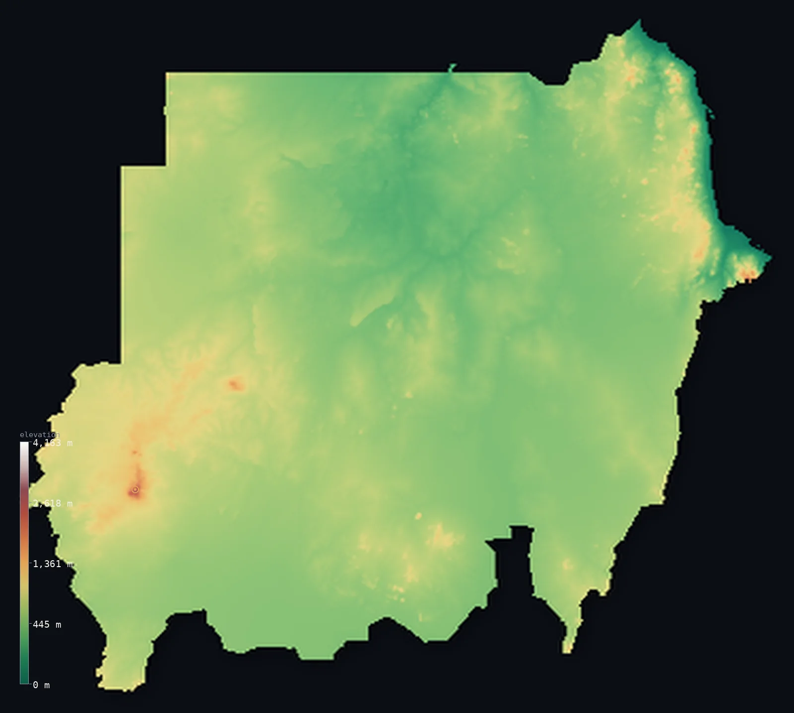
Sudan’s highest point is Deriba Caldera (Jebel Marra) at 9,980 ft (3,042 m); its lowest is Red Sea at 0 ft (0 m); the mean elevation is 1,736 ft (529 m).
Sudan is a vast plain, but not a low one. Nearly the whole country — about 99% of it — stands above 656 ft (200 m), and almost half above 1,640 ft (500 m): this is elevated desert and savanna, a broad tableland typically a few hundred metres up, not a sea-level lowland. Mountains rim it on three sides — the volcanic Jebel Marra in the west, the Red Sea Hills in the northeast, the Nuba Mountains in the south-centre — while the Nile threads through the middle, its two branches meeting at Khartoum. The high point, Deriba Caldera on Jebel Marra, reaches 9,980 ft (3,042 m).
- Highest point📚
- 9,980 ft3,042 m
- Sudan's highest point is Deriba Caldera, on the Jebel Marra massif in Darfur, at 9,980 ft (3,042 m) — a dormant volcano crowned by two crater lakes, rising as a green, rain-catching island far above the surrounding Sahel. Some sources give its height as 3,012 m; the figure here is the more commonly cited 3,042 m.
- Lowest point📚
- 0 ft0 m
- Sudan's lowest point is the Red Sea coast at sea level, in the far northeast — a narrow coastal plain backed almost immediately by the Red Sea Hills, which wall the shore off from the desert interior.
- Mean elevation⚙
- 1,736 ft529 m
- Sudan's mean elevation computed from the GLO-30 model is 1,736 ft (529 m) — and the figure tells the country's real story: this is not low desert but a raised plain, elevated a few hundred metres across almost its entire vast area.
- Median elevation⚙
- 1,611 ft491 m
- Half of Sudan lies above 1,611 ft (491 m) — close to the mean, the signature of a broadly uniform tableland. The country is remarkably even: mile after mile of plain at a similar height, interrupted only by the mountain massifs at its rim and the trench of the Nile.
- Elevation range📚
- 9,980 ft3,042 m
- From the Red Sea coast to the summit of Deriba Caldera, Sudan spans about 9,980 ft — but almost all of that height belongs to the few mountain massifs at the country's edges; across the great interior plain the land barely changes.
- Above 1,000 m (3,281 ft)⚙
- 3%
- Only about 3% of Sudan rises above 1,000 m (3,281 ft) — the Jebel Marra massif, the Red Sea Hills, and the Nuba Mountains. But almost the entire country, about 99%, stands above 200 m: Sudan is a high plain, not a low one.
- Official area📚
- 718,723 mi²1,861,484 km²
- Sudan covers about 719,000 sq mi (1,861,484 sq km) — the third-largest country in Africa, a great plain reaching from the deserts of the north through the Sahel to the savannas of the south, and from the Red Sea west to the mountains of Darfur.
- Forest cover📚
- 10%
- About 10% of Sudan is forested — acacia woodland and savanna across the wetter south and centre, the source of most of the world's gum arabic, thinning to nothing across the deserts of the north.
Highest and lowest points
Sudan's highest point is Deriba Caldera, at the summit of the Jebel Marra massif in Darfur, 9,980 ft (3,042 m) — a dormant volcano whose crater holds two lakes, and which rises high and green enough above the Sahel to catch rain and support cultivation, an island of temperate highland in the desert west. Its height became the country's highest only in 2011: before South Sudan seceded, Sudan's high point was Mount Kinyeti (3,187 m) in the Imatong Mountains of the far south, which now lies across the border. Sudan's summit changed not because the mountain moved, but because the country's border did. (Published heights for Deriba vary slightly; the figure here is the commonly cited 3,042 m, with 3,012 m given by some sources.)
source ↗Sudan's lowest point is the Red Sea coast at sea level, in the northeast, where a narrow coastal plain holds Port Sudan, the country's main seaport. The plain is short-lived: the Red Sea Hills rise steeply just inland, their abrupt eastern slopes catching what little rain blows in off the sea, their gentler western flanks inclining down toward the Nile. It is the only stretch of genuinely low ground in an otherwise elevated country.
source ↗Sudan at a glance
Sudan's highest point became Deriba Caldera (3,042 m) only in 2011, when South Sudan seceded - the former high point, Mount Kinyeti (3,187 m), now lies in South Sudan.
source ↗Deriba Caldera crowns Jebel Marra, a dormant volcano in Darfur whose crater holds two lakes; some sources give its height as 3,012 m rather than 3,042 m.
source ↗The Blue Nile and White Nile meet at Khartoum, whose name is traditionally said to mean 'elephant's trunk,' for the shape of the land at the confluence.
source ↗The Gezira Scheme, between the Blue and White Nile, is one of the largest irrigation projects in the world under a single management, covering some 8,800 sq km.
source ↗Sudan has more ancient pyramids than Egypt - over 200 Nubian and Kushite pyramids, most of them at Meroe.
source ↗Sudan produces most of the world's gum arabic - around 70 to 80% - a hardened acacia sap used in soft drinks, sweets, and pharmaceuticals.
source ↗Almost the whole of Sudan stands above 200 m - it is a raised desert and savanna plain rather than a low one.
source ↗The Red Sea Hills wall the country's short Red Sea coast off from the desert interior, rising steeply just inland from Port Sudan.
source ↗The Nuba Mountains rise as an island of hills above the clay plains of the south-centre, home to the Nuba peoples.
source ↗
Elevation profile of Sudan
The largest share of land, 50%, falls in the 400–600 m band, with the land split almost evenly above and below 500 m (1,640 ft).
- below 500 m (1,640 ft)52%
- 500–1,000 m46%
- 1,000–2,000 m2%
- above 2,000 m (6,562 ft)<1%
Highest peaks of Sudan
| Peak | Elevation | Range | Note |
|---|---|---|---|
| Deriba Caldera (Jebel Marra)↗ | 9,980 ft3,042 m | Marrah Mountains | Highest point of Sudan, the summit caldera of the Jebel Marra volcano in Darfur (3,042 m, though some sources give 3,012 m); other peaks of the massif also rise above 2,000 m. |
| Jabal Oda↗ | 7,411 ft2,259 m | Red Sea Hills | The highest named summit of the Red Sea Hills along Sudan's eastern coast; the nearby Jabal Erba reaches about 2,217 m. Elevation from mountaineering databases; no reliable summit coordinate, so it carries none. |
The Nile, the plains, and the mountains at the rim
The Nile valley and the northern deserts
The Nile threads the length of Sudan from south to north, its Blue and White branches meeting at Khartoum before the single river runs on toward Egypt. To either side lie the country's great deserts — the rocky Nubian Desert east of the river, the sandy Libyan and Bayuda deserts to the west and within its bends — among the driest and emptiest land in Africa, where the Nile is the only reliable water.
The central clay plains and the Gezira
The heart of the country is a vast flat plain of dark clay soils stretching between the two Niles and beyond — the Sahel belt, semi-arid but cultivable. Between the Blue and White Nile south of Khartoum lies the Gezira, watered by one of the world's largest irrigation schemes, the most productive farmland in Sudan.
The Marrah Mountains (Darfur)
In the far west, the Marrah Mountains rise as a volcanic massif from the Darfur plateau, culminating in Deriba Caldera, the country's high point, with its twin crater lakes. High enough to catch rain and stay green, Jebel Marra is a temperate island of terraced cultivation set in the desert and Sahel around it.
The Red Sea Hills (northeast)
Along the Red Sea coast in the northeast, a range of eroded granite and basement-rock hills rises steeply from a narrow coastal plain, separating the shore from the Nubian Desert inland. Their abrupt seaward slopes catch the winter rains blown off the Red Sea; their western flanks incline gently toward the Nile.
The Nuba Mountains (south-centre)
In South Kordofan, south of El Obeid, the Nuba Mountains rise as a cluster of rounded granite hills and inselbergs above the surrounding clay plains — a relatively low range, but a distinct island of high ground and the homeland of the Nuba peoples.
How to read this map
Color shows elevation; the raised relief shows real terrain. On this map Sudan reads as a broad, even expanse in the mid-tones of a raised plain, with brown-and-white high ground gathering only at the rim — the Jebel Marra massif in the west, the Red Sea Hills in the northeast, the Nuba Mountains in the south — and the Nile threading through the middle.
The 3D relief is the actual GLO-30 elevation data, exaggerated vertically so the mountain massifs and the river's course both show; the ×N relief slider controls how much. Tap anywhere to read that point's exact elevation.
City elevations in Sudan
Sudan's cities cluster on the Nile and its plains - Khartoum at the confluence of the two Niles, Wad Medani and Kosti on the river branches, with Port Sudan on the Red Sea coast and Nyala and El Fasher out on the western plains toward Darfur. Almost all sit on the raised interior plain, a few hundred metres above the sea.
| City | Population | Elevation |
|---|---|---|
| Khartoumcapitalthe capital, at the meeting of the Blue and White Nile, on the raised central plain ↗ | 1,974,647 | 1,263 ft385 m |
| Nyala | 565,734 | 2,165 ft660 m |
| Port Sudanon the Red Sea coast, the country's main seaport, beneath the Red Sea Hills ↗ | 489,725 | 23 ft7 m |
| Kassala | 401,477 | 1,663 ft507 m |
| El Obeid | 393,311 | 1,873 ft571 m |
| Al Qadarif | 363,945 | 1,978 ft603 m |
| Kosti | 345,068 | 1,266 ft386 m |
| Wad Medani | 332,714 | 1,342 ft409 m |
| El Daein | 264,734 | 1,562 ft476 m |
| El Fasher | 252,609 | 2,438 ft743 m |
Elevation sampled at each city centre from the Copernicus GLO-30 model. Cities and population from GeoNames (CC-BY 4.0).
Sudan in comparison
Sudan's terrain rises 9,980 ft (3,042 m) from sea level to Deriba Caldera (Jebel Marra) — about 34% of the height of Mount Everest, the world's highest point at 29,032 ft (8,849 m).
- Egypt's mean elevation is 988 ft — 748 ft lower; its high point, Mount Catherine (Gebel Katherina), reaches 8,625 ft (2,629 m), 1,355 ft below. Egypt elevation map →
- Chad's mean elevation is 1,696 ft — 39 ft lower; its high point, Emi Koussi, reaches 11,204 ft (3,415 m), 1,224 ft above. Chad elevation map →
- Ethiopia's mean elevation is 4,111 ft — 2,375 ft higher; its high point, Ras Dashen, reaches 14,928 ft (4,550 m), 4,948 ft above. Ethiopia elevation map →
Frequently asked questions
What is the highest point in Sudan?
- Deriba Caldera, on the Jebel Marra massif in Darfur, at 9,980 ft (3,042 m) - a dormant volcano with two crater lakes. It became the country's high point only in 2011, when South Sudan (holding the higher Mount Kinyeti) seceded.
What is the lowest point in Sudan?
- The Red Sea coast at sea level, in the northeast - the country's only stretch of genuinely low ground.
What is the average elevation of Sudan?
- Computed from the Copernicus GLO-30 model, the area-weighted mean is 1,736 ft (529 m) - and it reveals that Sudan is a raised plain, elevated a few hundred metres across almost its entire area, not a low desert.
Is Sudan flat?
- Largely, yes - but high. Almost the whole country is a broad, even plain, but that plain stands well above sea level: about 99% of Sudan is above 200 m. The only real relief is the mountain massifs at its rim.
Why did Sudan's highest point change in 2011?
- Until South Sudan became independent in 2011, Sudan's highest point was Mount Kinyeti (3,187 m) in the Imatong Mountains of the far south. That range is now in South Sudan, so Sudan's high point became Deriba Caldera (3,042 m) on Jebel Marra.
Is this a topographic, relief, contour, or elevation map of Sudan?
- They describe the same thing - terrain height. This page renders the country's actual elevation surface in interactive 3D and reports the statistics computed from it.
About this map
The terrain is rendered from the Copernicus GLO-30 digital elevation model (ESA), masked to the SDN-ADM0 boundary from geoBoundaries (gbOpen). Elevation statistics are computed directly from the model; peak names and researched facts are sourced and cited. See the methodology for the full pipeline.
Our area-weighted mean, computed from the Copernicus GLO-30 model, is 1,736 ft (529 m); the figure commonly cited elsewhere is 1,864 ft (568 m) (CIA World Factbook). Sudan is mostly low desert and semi-arid plains along the Nile, rising only in the peripheral hills and the volcanic Jebel Marra - so the mean elevation is moderate; the page reports the area-weighted figure computed from the Copernicus GLO-30 model.
Surveyed national figures: official area · forest cover · high point.
Rendered from Copernicus GLO-30 (ESA, 2021 release), boundaries from geoBoundaries. Generated 2026-07-26.
Bordering countries · 7
Sudan shares a land border with these countries — open any one to compare its terrain and highest point.