Ethiopia Elevation Map — Topographic & 3D Terrain
Explore the terrain of Ethiopia in interactive 3D, built from Copernicus GLO-30 satellite elevation data — a vast highland split down the middle by a continental rift. Drag to rotate, scroll to zoom, and tap any point to read its elevation.
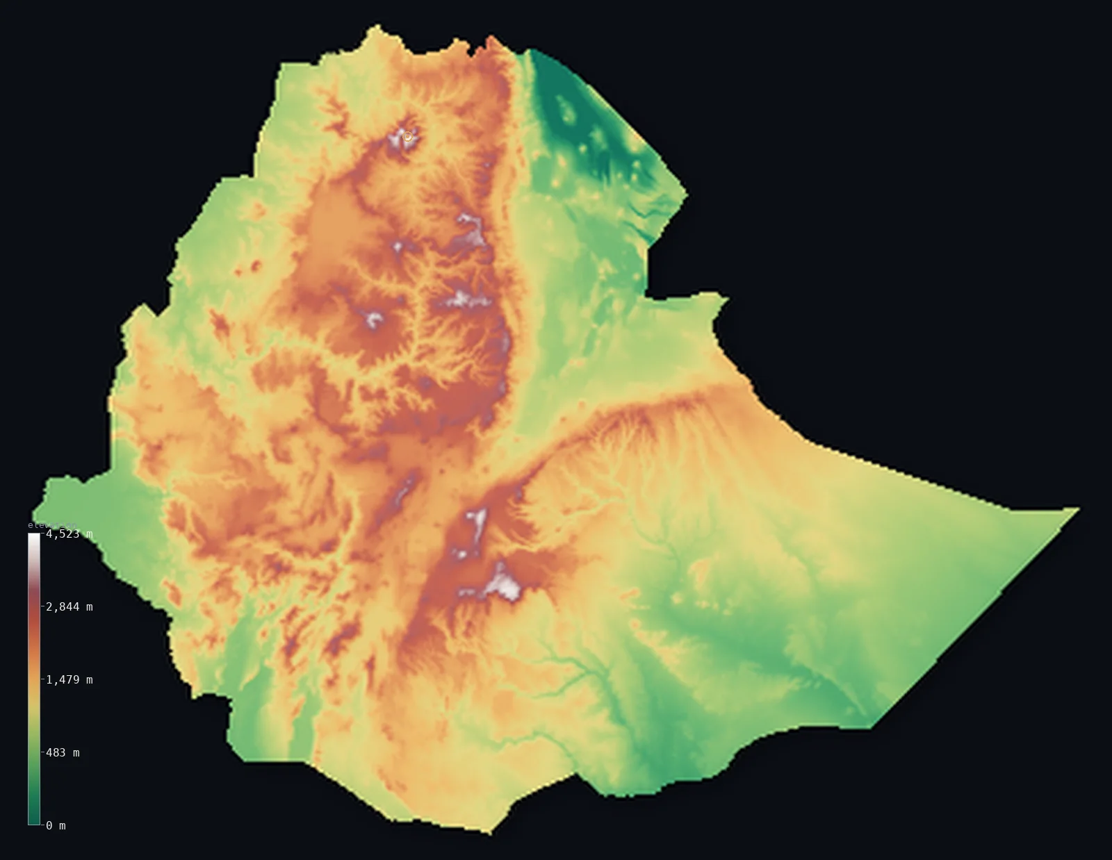
Ethiopia’s highest point is Ras Dashen at 14,928 ft (4,550 m); its lowest is Danakil Depression (Afar) at −410 ft (−125 m); the mean elevation is 4,111 ft (1,253 m).
Ethiopia is the roof of Africa, torn in half. More than half the country — 57% — stands above 3,281 ft (1,000 m), a massive block of highland high enough to be temperate at tropical latitude, rising to Ras Dashen at 14,928 ft (4,550 m). Straight through it runs the Great Rift Valley, a trench where the continent is slowly pulling apart, and at its northern end the land collapses to the Danakil Depression, 410 ft (125 m) below sea level and one of the hottest places on Earth.
- Highest point📚
- 14,928 ft4,550 m
- Ethiopia's highest point is Ras Dashen at 14,928 ft (4,550 m), in the Simien Mountains of the north — an eroded remnant of an enormous shield volcano, surrounded by the pinnacles and escarpments left as the highland's edge wore back.
- Lowest point📚
- −410 ft−125 m
- Ethiopia's lowest point is the Danakil Depression at 410 ft (125 m) below sea level — a salt desert of sulphur springs and lava lakes in the northeast, where average temperatures are among the highest recorded anywhere on the planet.
- Mean elevation⚙
- 4,111 ft1,253 m
- Ethiopia's mean elevation computed from the GLO-30 model is 4,111 ft (1,253 m) — genuinely high, one of the most elevated countries in Africa, and the reason its climate and agriculture look nothing like the lowland tropics that surround it.
- Median elevation⚙
- 3,750 ft1,143 m
- Half of Ethiopia lies above 3,750 ft (1,143 m) — below the mean, which tells you the country is not uniformly raised: a great highland block pulls the average up, while the rift floor and the lowland deserts of the east and south drag the middle back down.
- Elevation range📚
- 15,338 ft4,675 m
- From the Danakil Depression to the summit of Ras Dashen, Ethiopia spans about 15,300 ft — and the two extremes lie only a few hundred kilometres apart, on either side of the rift's northern end.
- Above 1,000 m (3,281 ft)⚙
- 57%
- About 57% of Ethiopia rises above 1,000 m (3,281 ft) — a majority of the country, and the reason Ethiopians call the highlands the country proper: this is where the rain falls, the crops grow, and almost everyone lives.
- Above 2,000 m (6,562 ft)⚙
- 16%
- Roughly 16% of Ethiopia stands above 2,000 m (6,562 ft) - the cultivated heart of the country, cool enough at that altitude to grow crops that would fail in the tropics below, and where most Ethiopians live.
- Official area📚
- 426,372 mi²1,104,300 km²
- Ethiopia covers about 426,000 sq mi (1,104,300 sq km) — a landlocked country built around a highland dome that gathers the rains and sends them out as rivers, above all the Blue Nile.
- Forest cover📚
- 11.2%
- About 11% of Ethiopia is forested — remnants of Afromontane woodland on the highland slopes, with the rift floor and the eastern lowlands giving way to scrubland and desert.
Highest and lowest points
Ethiopia's highest point is Ras Dashen, 14,928 ft (4,550 m), in the Simien Mountains of northern Ethiopia — the tenth-highest peak in Africa and the worn core of a vast ancient shield volcano. The Simiens around it are the highland's crumbling edge: millions of years of erosion have cut the plateau back into a landscape of sheer escarpments, isolated pinnacles, and deep gorges, high enough that snow occasionally falls within a few degrees of the equator.
source ↗Ethiopia's lowest point is the Danakil Depression, 410 ft (125 m) below sea level in the Afar region of the northeast. It is one of the strangest landscapes on Earth: a salt plain crusted yellow and green with sulphur, dotted with hot springs and acid pools, and holding Erta Ale, a volcano with a persistent lava lake. Average annual temperatures here are among the highest measured anywhere. It sits where three tectonic plates are pulling apart, and the ground is still sinking.
source ↗Ethiopia at a glance
Ras Dashen, 4,550 m, is Ethiopia's highest point and the tenth-highest peak in Africa - the eroded remnant of an enormous ancient shield volcano.
source ↗The Danakil Depression, 125 m below sea level, holds Dallol - the hottest place on Earth by annual average temperature - a salt desert of sulphur springs and lava lakes.
source ↗More than half of Ethiopia stands above 1,000 m - the highlands are high enough to be temperate despite sitting close to the equator.
source ↗The Great Rift Valley cuts diagonally across Ethiopia, splitting the highlands in two as the African continent slowly pulls apart.
source ↗The Blue Nile rises in Ethiopia's highlands at Lake Tana and supplies the majority of the Nile's water during the flood season.
source ↗Ethiopia is sometimes called the water tower of East Africa - its highland dome catches the rains that feed rivers across the region.
source ↗
Elevation profile of Ethiopia
The largest share of land, 28%, falls in the 500–1,000 m band, and 85% of the territory lies above 500 m (1,640 ft).
- below 500 m (1,640 ft)15%
- 500–1,000 m28%
- 1,000–2,000 m41%
- above 2,000 m (6,562 ft)16%
Highest peaks of Ethiopia
| Peak | Elevation | Range | Note |
|---|---|---|---|
| Ras Dashen↗ | 14,928 ft4,550 m | Simien Mountains (north) | Highest point of Ethiopia, the rim of an ancient volcano in the Simien Mountains. |
| Mount Biuat↗ | 14,557 ft4,437 m | Simien Mountains (north) | Ras Dashen's western counterpart, across the valley of the Meshaha River. |
| Tullu Demtu↗ | 14,360 ft4,377 m | Bale Mountains (southeast) | The highest peak of the Bale Mountains, across the Great Rift Valley in the southeast. |
| Mount Batu↗ | 14,131 ft4,307 m | Bale Mountains (southeast) | A high peak of the Bale massif on the Sanetti Plateau, home to the Ethiopian wolf. |
| Mount Chilalo↗ | 13,241 ft4,036 m | Arsi Mountains (Rift margin) | A prominent peak of the Arsi highlands on the eastern edge of the Rift Valley. |
A highland split by a rift
The Ethiopian Highlands
The heart of the country is a vast raised block of ancient volcanic rock, mostly between 2,000 and 3,000 m and rising higher in the Simien and Bale ranges. Cool, well-watered, and fertile, it holds the great majority of Ethiopia's people and farmland — the reason a tropical country has a temperate heartland.
The Great Rift Valley
A trench runs diagonally across the country from the Afar in the northeast to the Kenyan border in the southwest, splitting the highlands into western and eastern halves. Its floor is lower, hotter, and drier than the plateaus above it, strung with lakes along its length, and it is still widening as the continent tears apart.
The Danakil and the Afar lowlands
At the rift's northern end the land drops below sea level into the Danakil Depression — salt flats, sulphur fields, and active volcanoes in one of the hottest, most inhospitable landscapes on the planet.
The eastern and southern lowlands
Away from the highlands the country falls into arid lowland — the Ogaden in the southeast and the borderlands toward Somalia and Kenya — dry scrub and semi-desert that make up a large share of the area but hold comparatively few people.
How to read this map
Color shows elevation; the raised relief shows real terrain. On this map Ethiopia reads as a great brown-and-white highland dome with a distinct trench cut diagonally through it — the Rift Valley — and a dark hollow at its northeastern end where the Danakil drops below sea level.
The 3D relief is the actual GLO-30 elevation data, exaggerated vertically so the rift's cut and the highland's edge both stand out; the ×N relief slider controls how much. Tap anywhere to read that point's exact elevation.
City elevations in Ethiopia
Ethiopian cities sit high. Addis Ababa stands at around 7,700 ft, among the highest capital cities in the world, and the other highland towns are not far below - a consequence of everyone living on the plateau rather than in the hot lowlands.
| City | Population | Elevation |
|---|---|---|
| Addis Ababacapitalthe capital, on the highland plateau at about 2,350 m - one of the highest capitals in the world ↗ | 3,860,000 | 7,884 ft2,403 m |
| Jijiga | 483,000 | 5,394 ft1,644 m |
| Gonder | 466,000 | 7,208 ft2,197 m |
| Mek'ele | 457,900 | 6,772 ft2,064 m |
| Warder | 450,400 | 1,811 ft552 m |
| Awasa | 422,200 | 5,554 ft1,693 m |
| Dessie | 270,400 | 8,186 ft2,495 m |
| Jimma | 250,900 | 5,627 ft1,715 m |
| Arba Minch | 201,000 | 4,157 ft1,267 m |
| Nek’emtē | 156,000 | 6,890 ft2,100 m |
Elevation sampled at each city centre from the Copernicus GLO-30 model. Cities and population from GeoNames (CC-BY 4.0).
Ethiopia in comparison
Ethiopia's terrain rises 15,338 ft (4,675 m) from Danakil Depression (Afar), 410 ft (125 m) below sea level to Ras Dashen — about 53% of the height of Mount Everest, the world's highest point at 29,032 ft (8,849 m).
- Eritrea's mean elevation is 2,507 ft — 1,604 ft lower; its high point, Emba Soira, reaches 9,902 ft (3,018 m), 5,026 ft below. Eritrea elevation map →
- Kenya's mean elevation is 2,575 ft — 1,535 ft lower; its high point, Mount Kenya (Batian), reaches 17,057 ft (5,199 m), 2,129 ft above. Kenya elevation map →
- Somalia's mean elevation is 1,375 ft — 2,736 ft lower; its high point, Mount Shimbiris, reaches 8,071 ft (2,460 m), 6,857 ft below. Somalia elevation map →
Frequently asked questions
What is the highest point in Ethiopia?
- Ras Dashen, 14,928 ft (4,550 m), in the Simien Mountains - the tenth-highest peak in Africa.
What is the lowest point in Ethiopia?
- The Danakil Depression, 410 ft (125 m) below sea level - a salt desert in the northeast and one of the hottest places on Earth.
What is the average elevation of Ethiopia?
- Computed from the Copernicus GLO-30 model, the area-weighted mean is 4,111 ft (1,253 m) - one of the highest in Africa, because a vast highland block covers the centre of the country.
Why are the Ethiopian Highlands cool if Ethiopia is tropical?
- Altitude - most of the highlands sit between 2,000 and 3,000 m, high enough that the climate is temperate despite the country's position near the equator.
What is the Great Rift Valley in Ethiopia?
- A continental trench cutting diagonally across the country, splitting the highlands in two, where tectonic plates are slowly pulling apart - it is still widening today.
Is this a topographic, relief, contour, or elevation map of Ethiopia?
- They describe the same thing - terrain height. This page renders the country's actual elevation surface in interactive 3D and reports the statistics computed from it.
About this map
The terrain is rendered from the Copernicus GLO-30 digital elevation model (ESA), masked to the ETH-ADM0 boundary from geoBoundaries (gbOpen). Elevation statistics are computed directly from the model; peak names and researched facts are sourced and cited. See the methodology for the full pipeline.
Our area-weighted mean, computed from the Copernicus GLO-30 model, is 4,111 ft (1,253 m); the figure commonly cited elsewhere is 4,364 ft (1,330 m) (CIA World Factbook). Ethiopia is dominated by a vast high plateau - the Ethiopian Highlands, the 'Roof of Africa', much of it above 1,500 m - which keeps the mean elevation high despite the deep Danakil Depression and lowland margins; the page reports the area-weighted figure computed from the Copernicus GLO-30 model.
Surveyed national figures: official area · forest cover · high point.
Rendered from Copernicus GLO-30 (ESA, 2021 release), boundaries from geoBoundaries. Generated 2026-06-23.
Bordering countries · 6
Ethiopia shares a land border with these countries — open any one to compare its terrain and highest point.