Somalia Elevation Map — Topographic & 3D Terrain
Explore the terrain of Somalia in interactive 3D, built from Copernicus GLO-30 satellite elevation data — the Horn of Africa, a long coast and low plains rising to northern highlands. Drag to rotate, scroll to zoom, and tap any point to read its elevation.
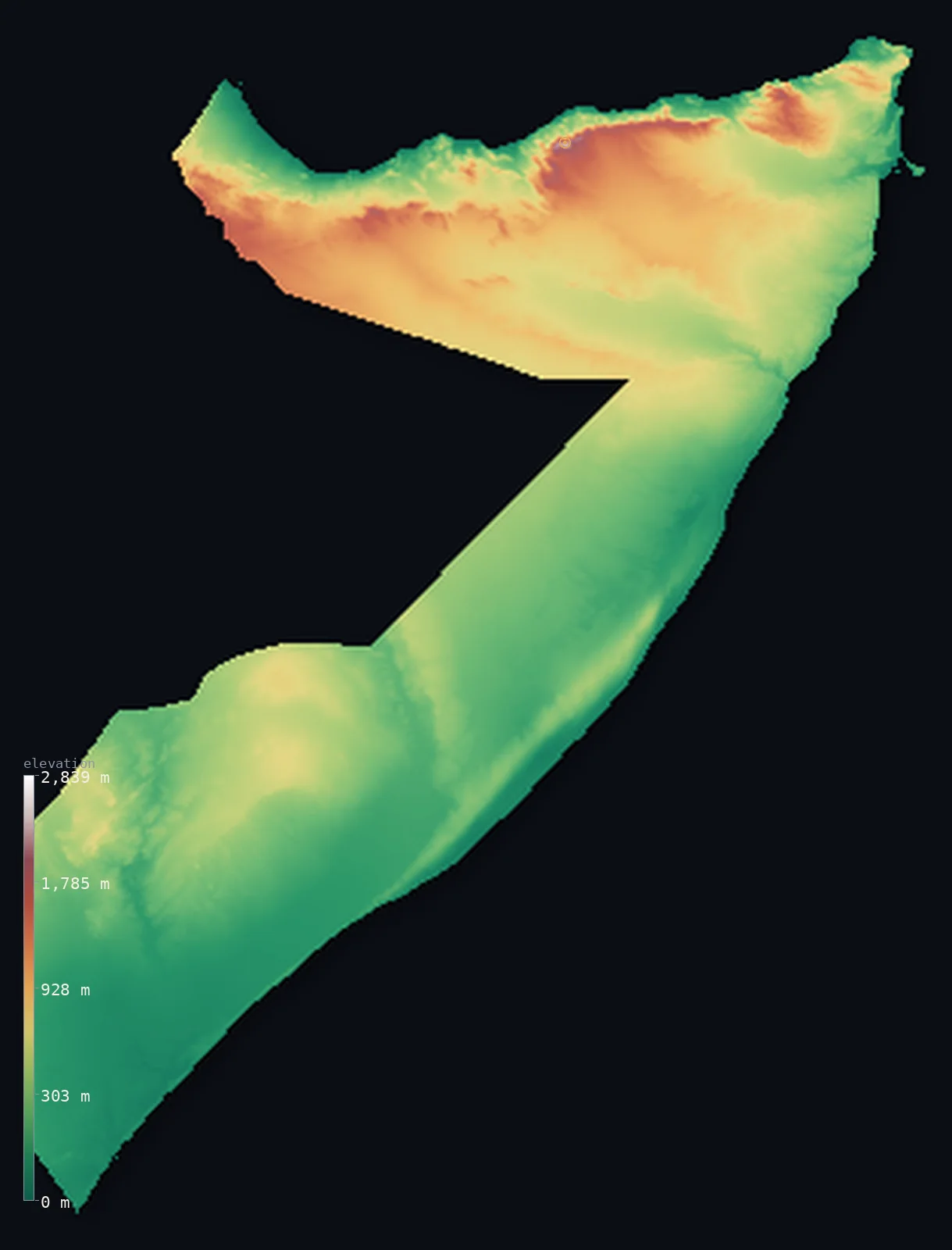
Somalia’s highest point is Mount Shimbiris at 8,071 ft (2,460 m); its lowest is Indian Ocean at 0 ft (0 m); the mean elevation is 1,375 ft (419 m).
Somalia occupies the Horn of Africa, the continent's easternmost tip — a country of long coasts and mostly low, dry country. Its coastline, on the Gulf of Aden to the north and the Indian Ocean to the east and south, is one of the longest in mainland Africa. Much of the country is low plateau, semi-desert scrub, and plain, rising gently inland; in the south, two rivers, the Jubba and the Shabelle, water the only substantial farmland. The high ground is in the north: behind the Gulf of Aden coast, the land climbs to the rugged Cal Madow and Golis ranges, which hold the country's highest point, Shimbiris, at 8,071 ft (2,460 m).
- Highest point📚
- 8,071 ft2,460 m
- Somalia's highest point is Shimbiris at 8,071 ft (2,460 m), in the Cal Madow mountains of the far north, behind the Gulf of Aden coast — the highest of the northern highlands that rim the coast, rising steeply above the sea and the interior plateau. It is by far the highest ground in a country that is otherwise mostly low.
- Lowest point📚
- 0 ft0 m
- Somalia's lowest point is the sea at sea level, along one of the longest coastlines in mainland Africa — the Gulf of Aden in the north and the long Indian Ocean shore to the east and south, from Cape Guardafui at the very tip of the Horn down the whole eastern side of the country.
- Mean elevation⚙
- 1,375 ft419 m
- Computed from the GLO-30 model, Somalia's mean elevation is 1,375 ft (419 m) — low, the mark of a dry, low Horn: semi-desert plateau and coastal plain make up nearly all of it, sloping gently up from the long coasts, with real height only in the far-northern mountains.
- Median elevation⚙
- 991 ft302 m
- Half of Somalia lies below about 991 ft (302 m) — a good deal lower than the mean, which the small but high northern mountains pull upward while the vast low coastal plains and southern lowlands hold the middle down.
- Elevation range📚
- 8,071 ft2,460 m
- Somalia's terrain spans about 8,070 ft from the coast to Shimbiris' 2,460 m — but the climb is all in the far north: behind the Gulf of Aden the land jumps to the Cal Madow mountains, while the rest of the country, plateau and coastal plain, stays low.
- Above 1,000 m (3,281 ft)⚙
- 9%
- About 9% of Somalia rises above 1,000 m (3,281 ft) — the higher interior plateau (the Ogo and Haud) and the northern Cal Madow mountains; 32% of the country clears 500 m. The coastal plains and the southern river lowlands lie lower.
- Official area📚
- 246,201 mi²637,657 km²
- Somalia covers about 246,200 sq mi (637,657 sq km) — a country on the Horn of Africa with one of the longest coastlines in mainland Africa, mostly low plateau and semi-desert plain, rising to the Cal Madow mountains in the north, and watered in the south by the Jubba and Shabelle rivers.
- Forest cover📚
- 9.6%
- About 10% of Somalia is forested — very little, as most of the country is semi-desert scrub, dry grassland, and thornbush; what denser vegetation there is lies along the southern rivers and on the wetter northern mountains.
Highest and lowest points
Somalia's highest point is Shimbiris, 8,071 ft (2,460 m), in the Cal Madow range of the far north, a short way inland from the Gulf of Aden coast. The northern highlands here — the Cal Madow and Golis ranges, and the Ogo plateau behind them — are the highest and, in places, greenest part of the country, rising steeply from the narrow coastal plain and holding relict patches of ancient juniper and even the frankincense trees for which the Horn has been famous since antiquity. Shimbiris is their summit, and by far the highest point in Somalia — the rest of the country, the vast interior plateau and the southern plains, lies far lower.
source ↗Somalia's lowest point is the sea at sea level, along a coastline that is one of the longest in mainland Africa — the Gulf of Aden in the north and, around the sharp point of Cape Guardafui at the tip of the Horn, the long Indian Ocean shore running the whole eastern and southern length of the country. Behind this coast the land rises: gently, across the vast dry plateau and plains that make up most of Somalia, and steeply in the north, where the Cal Madow and Golis ranges wall the Gulf of Aden. The only major rivers, the Jubba and the Shabelle, flow down from the Ethiopian highlands into the south, watering the country's main farmland before reaching (or, in the Shabelle's case, nearly reaching) the Indian Ocean.
source ↗Somalia at a glance
Mount Shimbiris (about 2,460 m) is less a peak than a broad summit on a high escarpment, ringed by other tops above 2,200 m.
source ↗Somalia has one of the longest coastlines of any country on mainland Africa - more than 3,300 km.
source ↗Only two rivers, the Jubba and Shabelle in the southwest, flow all year - the rest of the country has no permanent rivers.
source ↗The high Cal Madow range is cool and partly forested, a sharp contrast to the arid plains that cover most of the country.
source ↗The Haud grasslands extend across the border deep into Ethiopia, long an important grazing area.
source ↗
Elevation profile of Somalia
The largest share of land, 36%, falls in the 0–200 m band, and 68% of the territory lies below 500 m (1,640 ft).
- below 500 m (1,640 ft)68%
- 500–1,000 m23%
- 1,000–2,000 m9%
- above 2,000 m (6,562 ft)<1%
Highest peaks of Somalia
| Peak | Elevation | Range | Note |
|---|---|---|---|
| Mount Shimbiris↗ | 8,071 ft2,460 m | Cal Madow (northern highlands) | Highest point of Somalia, in the northern Cal Madow range near Erigavo; the escarpment around it carries several other summits above 2,200 m. |
Somalia: the coasts and coastal plains, the interior plateau, and the northern mountains
The coasts and coastal plains
Somalia's long coasts — the Gulf of Aden in the north, the Indian Ocean east and south — are among the longest in Africa, backed mostly by low coastal plains, narrow in the north below the mountains, wider in the south. The country's extensive, mostly dry, seaward edge.
The interior plateau
Most of Somalia is dry interior plateau — semi-desert scrub, thornbush, and grassland plain, rising gently from the coasts and higher toward the north (the Ogo and Haud). Vast, arid, and thinly settled, it is the bulk of the country.
The northern mountains and the southern rivers
In the north, behind the Gulf of Aden, rise the Cal Madow and Golis ranges (holding Shimbiris, the high point) — the country's highest ground. In the south, the Jubba and Shabelle rivers water the only substantial farmland. The high north and the watered south, bracketing the dry plateau.
How to read this map
Color shows elevation; the raised relief shows real terrain. On this map Somalia reads as a low country with a high northern rim — broad low-to-mid tones covering most of it (the dry interior plateau and the coastal plains), with the browns of the northern Cal Madow and Golis mountains rising behind the Gulf of Aden coast (highest at Shimbiris), and the low southern plains along the Jubba and Shabelle.
The 3D relief is the actual GLO-30 elevation data, exaggerated vertically so the low plateau and the northern mountains both show; the ×N relief slider controls how much. Tap anywhere to read that point's exact elevation.
City elevations in Somalia
Somalia's cities lie along the coasts and the southern rivers — Mogadishu, the capital, on the Indian Ocean coast, Berbera and Bosaso on the Gulf of Aden in the north, Borama in the northwestern highlands, and Kismayo and Baidoa in the south. Most sit by the sea or the rivers.
| City | Population | Elevation |
|---|---|---|
| Mogadishucapitalthe capital, on the Indian Ocean coast ↗ | 2,587,183 | 46 ft14 m |
| Boramain the northwestern highlands ↗ | 597,842 | 4,803 ft1,464 m |
| Berberaa port on the Gulf of Aden coast ↗ | 242,344 | 33 ft10 m |
| Kismayoa port on the southern coast ↗ | 234,852 | 39 ft12 m |
| El Dibirin the far northeast ↗ | 200,000 | 157 ft48 m |
| Baidoain the southern interior ↗ | 129,839 | 1,453 ft443 m |
| Kaamboonion the far southern coast, near Kenya ↗ | 79,000 | 13 ft4 m |
| Bosasoa port on the Gulf of Aden coast ↗ | 74,287 | 36 ft11 m |
| Beled Hawoin the southwest, on the Kenyan border ↗ | 73,000 | 705 ft215 m |
| Gaalkacyoon the central plateau ↗ | 61,200 | 948 ft289 m |
Elevation sampled at each city centre from the Copernicus GLO-30 model. Cities and population from GeoNames (CC-BY 4.0).
Somalia in comparison
Somalia's terrain rises 8,071 ft (2,460 m) from sea level to Mount Shimbiris — about 28% of the height of Mount Everest, the world's highest point at 29,032 ft (8,849 m).
- Ethiopia's mean elevation is 4,111 ft — 2,736 ft higher; its high point, Ras Dashen, reaches 14,928 ft (4,550 m), 6,857 ft above. Ethiopia elevation map →
- Kenya's mean elevation is 2,575 ft — 1,201 ft higher; its high point, Mount Kenya (Batian), reaches 17,057 ft (5,199 m), 8,986 ft above. Kenya elevation map →
- Djibouti's mean elevation is 1,467 ft — 92 ft higher; its high point, Mousa Ali, reaches 6,654 ft (2,028 m), 1,417 ft below. Djibouti elevation map →
- Eritrea's mean elevation is 2,507 ft — 1,132 ft higher; its high point, Emba Soira, reaches 9,902 ft (3,018 m), 1,831 ft above. Eritrea elevation map →
Frequently asked questions
What is the highest point in Somalia?
- Shimbiris, 8,071 ft (2,460 m), in the Cal Madow mountains of the far north, behind the Gulf of Aden coast — the highest of the northern highlands.
What is the lowest point in Somalia?
- The sea at sea level, along one of the longest coastlines in mainland Africa — the Gulf of Aden and the Indian Ocean, around the Horn.
What is the average elevation of Somalia?
- Computed from the Copernicus GLO-30 model, the area-weighted mean is 1,375 ft (419 m) — low, because Somalia is mostly low, dry plateau and plain, with real high ground only in the northern mountains.
How long is Somalia's coastline?
- One of the longest in mainland Africa — running along the Gulf of Aden in the north and the Indian Ocean down the whole eastern and southern side of the country, around the Horn.
Is Somalia mountainous?
- Mostly not — it is a low, dry country of plateau and plain, with real mountains only in the far north (the Cal Madow, holding Shimbiris, 2,460 m) behind the Gulf of Aden.
Is this a topographic, relief, contour, or elevation map of Somalia?
- They describe the same thing — terrain height. This page renders the country's actual elevation surface in interactive 3D and reports the statistics computed from it.
About this map
The terrain is rendered from the Copernicus GLO-30 digital elevation model (ESA), masked to the SOM-ADM0 boundary from geoBoundaries (gbOpen). Elevation statistics are computed directly from the model; peak names and researched facts are sourced and cited. See the methodology for the full pipeline.
Our area-weighted mean, computed from the Copernicus GLO-30 model, is 1,375 ft (419 m); the figure commonly cited elsewhere is 1,345 ft (410 m) (CIA World Factbook). Somalia is mostly plateau and plain - a vast semi-arid interior between the northern mountains and the long coast - giving a moderate mean despite the 2,460 m highlands in the far north; the page reports the area-weighted figure computed from the Copernicus GLO-30 model.
Surveyed national figures: official area · forest cover · high point.
Rendered from Copernicus GLO-30 (ESA, 2021 release), boundaries from geoBoundaries. Generated 2026-06-26.
Bordering countries · 3
Somalia shares a land border with these countries — open any one to compare its terrain and highest point.