Kenya Elevation Map — Topographic & 3D Terrain
Explore the terrain of Kenya in interactive 3D, built from Copernicus GLO-30 satellite elevation data — dry lowlands, a compact fertile highland, and one glaciated volcano on the equator. Drag to rotate, scroll to zoom, and tap any point to read its elevation.
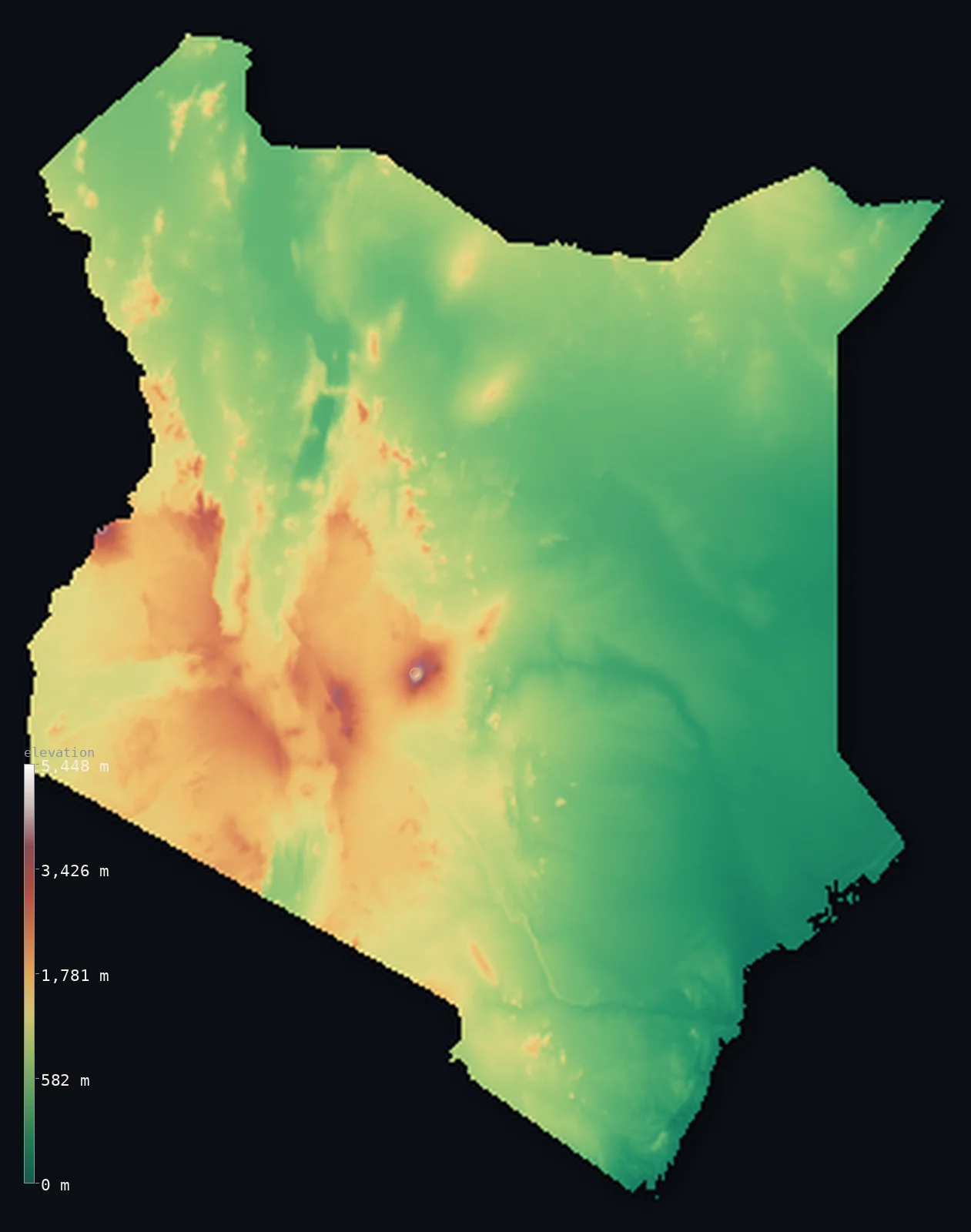
Kenya’s highest point is Mount Kenya (Batian) at 17,057 ft (5,199 m); its lowest is Indian Ocean at 0 ft (0 m); the mean elevation is 2,575 ft (785 m).
Kenya is mostly low and dry, and then, in the middle of it, there is a mountain with glaciers on the equator. Half the country lies below 1,919 ft (585 m) — the coastal plain, the thorn scrub of the east, the deserts around Lake Turkana — while a compact highland core rises in the centre and the Great Rift Valley cuts through it. Above everything stands Mount Kenya at 17,057 ft (5,199 m), an extinct volcano whose glaciers have been retreating for a century and are nearly gone.
- Highest point📚
- 17,057 ft5,199 m
- Kenya's highest point is Mount Kenya at 17,057 ft (5,199 m), an eroded volcano standing almost exactly on the equator — high enough to carry glaciers at that latitude, though they have shrunk dramatically over the past century and are now a fraction of their recorded extent.
- Lowest point📚
- 0 ft0 m
- Kenya's lowest point is the Indian Ocean at sea level, along a coral-fringed coast in the southeast — the low, hot end of a country whose interior climbs to more than 5,000 m.
- Mean elevation⚙
- 2,575 ft785 m
- Kenya's mean elevation computed from the GLO-30 model is 2,575 ft (785 m) — a figure lifted well above the country's typical ground by a compact block of highland in the centre and west, since most of Kenya by area is low, dry lowland.
- Median elevation⚙
- 1,919 ft585 m
- Half of Kenya lies below 1,919 ft (585 m) — a couple of hundred metres under the mean, and the clearest statement of the country's shape: the highlands are fertile, populous and famous, but they are a minority of the land, while the arid north and east make up most of it.
- Elevation range📚
- 17,057 ft5,199 m
- From the Indian Ocean to the summit of Mount Kenya, the country spans about 17,050 ft — and crosses climate zones on the way, from coral coast through thorn savanna to alpine moorland and permanent ice within two degrees of the equator.
- Above 1,000 m (3,281 ft)⚙
- 29%
- About 29% of Kenya rises above 1,000 m (3,281 ft) — the central and western highlands on either side of the Rift Valley, where the rainfall, the farmland and most of the population are concentrated.
- Above 2,000 m (6,562 ft)⚙
- 6%
- Roughly 6% of Kenya stands above 2,000 m (6,562 ft) — the high shoulders of the Rift, the Aberdare range, and the flanks of Mount Kenya and Mount Elgon, cool country where tea and highland farming replace the savanna below.
- Official area📚
- 224,081 mi²580,367 km²
- Kenya covers about 224,000 sq mi (580,367 sq km) — straddling the equator from the Indian Ocean to Lake Victoria, with the Rift Valley running north to south through the middle of it.
- Forest cover📚
- 6.3%
- About 6.3% of Kenya is forested — concentrated on the highland slopes and the mountain massifs, where the rain falls; the arid north and east carry scrub and savanna rather than woodland.
Highest and lowest points
Kenya's highest point is Mount Kenya, 17,057 ft (5,199 m), an extinct volcano rising in splendid isolation from the plains almost exactly on the equator. Its summit is a set of jagged rock spires — the eroded plug of a much larger cone — and it is high enough to hold glaciers within sight of the equator. Those glaciers are the story: they have been retreating since they were first surveyed, most of the recorded ice has gone, and what remains is expected to disappear within decades. The mountain gave the country its name.
source ↗Kenya's lowest point is the Indian Ocean at sea level, along a coast of coral reef, mangrove creek and white sand running from Somalia down to Tanzania. The coastal strip is narrow, hot and humid — a different world from the cool highlands a few hundred kilometres inland, and separated from them by a wide belt of dry thorn country that makes up much of eastern Kenya.
source ↗Kenya at a glance
Mount Kenya, 5,199 m, carries glaciers almost exactly on the equator - and they have retreated so far since they were first surveyed that most of the recorded ice is gone.
source ↗Mount Kenya's summit is not a cone but a cluster of rock spires - the hard eroded plug of a much larger volcano worn away over millions of years.
source ↗Half of Kenya lies below about 585 m - the highlands are famous but they are a minority of the country, which is largely arid lowland.
source ↗The Great Rift Valley runs north to south through Kenya, its floor strung with lakes and its walls rising to the highlands on either side.
source ↗Lake Turkana in the far north is the largest desert lake in the world, lying in one of the hottest and driest parts of the country.
source ↗Before glaciation Mount Kenya is estimated to have stood about 7,000 m high; erosion has since cut it down to its present 5,199 m.
source ↗The Republic of Kenya takes its name from the mountain, which was a sacred site in traditional Gikuyu religion.
source ↗
Elevation profile of Kenya
The largest share of land, 42%, falls in the 0–500 m band, and 58% of the territory lies above 500 m (1,640 ft).
- below 500 m (1,640 ft)42%
- 500–1,000 m29%
- 1,000–2,000 m23%
- above 2,000 m (6,562 ft)6%
Highest peaks of Kenya
| Peak | Elevation | Range | Note |
|---|---|---|---|
| Mount Kenya (Batian)↗ | 17,057 ft5,199 m | Central Highlands | Highest point of Kenya and the second-highest mountain in Africa, an equatorial stratovolcano carrying small glaciers. |
| Mount Elgon (Wagagai, Uganda)↗ | 14,177 ft4,321 m | Uganda border (west) | A huge extinct shield volcano on the Uganda border; its summit, Wagagai, is on the Ugandan side, with Kenya's highest points (Sudek, Koitobos) just over 4,200 m. |
| Ol Doinyo Lesatima (Satima)↗ | 13,127 ft4,001 m | Aberdare Range (central) | The highest point of the Aberdare Range, west of Mount Kenya across a high plateau. |
| Cherangani Hills↗ | 11,581 ft3,530 m | Western Highlands | A high range of the western highlands, one of Kenya's main forested 'water towers'. |
| Mount Longonot↗ | 9,108 ft2,776 m | Great Rift Valley (central) | A young dormant volcano with a dramatic crater, rising from the floor of the Great Rift Valley near Lake Naivasha. |
Dry lowland, a highland core, and the Rift
The central highlands and Mount Kenya
A compact block of high, fertile, well-watered country sits in the centre of Kenya, rising from about 1,500 m to the Aberdare range and, above them all, the isolated bulk of Mount Kenya. This is where the rain falls and where most Kenyans live and farm — a small share of the country's area holding most of its people.
The Great Rift Valley
The Rift cuts north to south straight through the highlands, a broad trench with steep walls and a floor strung with lakes — Naivasha, Nakuru, Bogoria, Baringo — and volcanic cones. It splits the highland block into eastern and western halves and is still slowly widening.
The northern and eastern drylands
Most of Kenya by area is arid or semi-arid: the thorn scrub of the east, the stony deserts of the north around Lake Turkana, and the plains that run toward Somalia. Hot, sparsely populated, and low, this is the country's statistical bulk.
The coast and the Lake Victoria basin
At the two far edges the land drops again — eastward to the narrow, humid Indian Ocean coast with its reefs and mangroves, and westward down the Rift's far wall to the green, densely settled basin around Lake Victoria.
How to read this map
Color shows elevation; the raised relief shows real terrain. On this map Kenya reads as broad low country in greens and browns, with a compact raised highland in the centre split by the dark line of the Rift, and a single white point where Mount Kenya breaks above the rest.
The 3D relief is the actual GLO-30 elevation data, exaggerated vertically so both the Rift's trench and the isolated massifs show; the ×N relief slider controls how much. Tap anywhere to read that point's exact elevation.
City elevations in Kenya
Kenya's cities follow the highlands. Nairobi sits at about 5,900 ft on the edge of the central highland block - one of the highest capital cities in Africa - while Mombasa lies at sea level on the Indian Ocean coast, and Kisumu low on the shore of Lake Victoria.
| City | Population | Elevation |
|---|---|---|
| Nairobicapitalthe capital, on the southern edge of the central highlands at about 1,795 m ↗ | 4,397,073 | 5,499 ft1,676 m |
| Kakamega | 1,867,579 | 5,115 ft1,559 m |
| Mombasaon the Indian Ocean coast at sea level, Kenya's main port ↗ | 1,208,333 | 69 ft21 m |
| Nakuru | 570,674 | 5,922 ft1,805 m |
| Garissa | 163,399 | 492 ft150 m |
| Malindi | 119,859 | 23 ft7 m |
| Mandera | 114,718 | 699 ft213 m |
| Kisii | 112,417 | 5,512 ft1,680 m |
| Wajir | 90,116 | 846 ft258 m |
| Lodwar | 82,970 | 1,647 ft502 m |
Elevation sampled at each city centre from the Copernicus GLO-30 model. Cities and population from GeoNames (CC-BY 4.0).
Kenya in comparison
Kenya's terrain rises 17,057 ft (5,199 m) from sea level to Mount Kenya (Batian) — about 59% of the height of Mount Everest, the world's highest point at 29,032 ft (8,849 m).
- Tanzania's mean elevation is 3,340 ft — 764 ft higher; its high point, Kilimanjaro (Uhuru Peak), reaches 19,341 ft (5,895 m), 2,283 ft above. Tanzania elevation map →
- Uganda's mean elevation is 3,822 ft — 1,247 ft higher; its high point, Margherita Peak (Mount Stanley), reaches 16,762 ft (5,109 m), 295 ft below. Uganda elevation map →
- Ethiopia's mean elevation is 4,111 ft — 1,535 ft higher; its high point, Ras Dashen, reaches 14,928 ft (4,550 m), 2,129 ft below. Ethiopia elevation map →
Frequently asked questions
What is the highest point in Kenya?
- Mount Kenya, 17,057 ft (5,199 m), an extinct volcano standing almost exactly on the equator - and still carrying glaciers, though they have nearly vanished.
What is the lowest point in Kenya?
- The Indian Ocean at sea level, along the coral-fringed southeastern coast.
What is the average elevation of Kenya?
- Computed from the Copernicus GLO-30 model, the area-weighted mean is 2,575 ft (785 m) - lifted by the central highlands, though half the country lies below about 585 m.
Does Mount Kenya have glaciers?
- Yes, though barely. It is one of the few places on the equator with permanent ice, and its glaciers have retreated so far since first being surveyed that most of the recorded ice has gone.
Where does the Great Rift Valley run in Kenya?
- North to south through the middle of the country, cutting the central highlands into eastern and western halves, with a floor strung with lakes and volcanic cones.
Is this a topographic, relief, contour, or elevation map of Kenya?
- They describe the same thing - terrain height. This page renders the country's actual elevation surface in interactive 3D and reports the statistics computed from it.
About this map
The terrain is rendered from the Copernicus GLO-30 digital elevation model (ESA), masked to the KEN-ADM0 boundary from geoBoundaries (gbOpen). Elevation statistics are computed directly from the model; peak names and researched facts are sourced and cited. See the methodology for the full pipeline.
Our area-weighted mean, computed from the Copernicus GLO-30 model, is 2,575 ft (785 m); the figure commonly cited elsewhere is 2,500 ft (762 m) (CIA World Factbook). Kenya rises from the Indian Ocean coast across eastern plains to a high central plateau (1,500-2,400 m) split by the Great Rift Valley, so its mean elevation is high; the page reports the area-weighted figure computed from the Copernicus GLO-30 model.
Surveyed national figures: official area · forest cover · high point.
Rendered from Copernicus GLO-30 (ESA, 2021 release), boundaries from geoBoundaries. Generated 2026-06-23.
Bordering countries · 5
Kenya shares a land border with these countries — open any one to compare its terrain and highest point.