South Sudan Elevation Map — Topographic & 3D Terrain
Explore the terrain of South Sudan in interactive 3D, built from Copernicus GLO-30 satellite elevation data — a vast, low White Nile basin and the great Sudd wetland, rimmed by highlands. Drag to rotate, scroll to zoom, and tap any point to read its elevation.
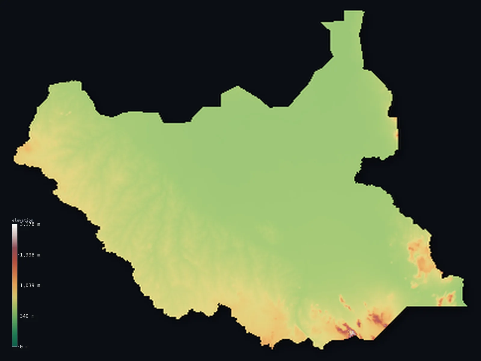
South Sudan’s highest point is Mount Kinyeti at 10,456 ft (3,187 m); its lowest is White Nile at 1,250 ft (381 m); the mean elevation is 1,686 ft (514 m).
South Sudan is a vast, low, flat basin in the heart of the White Nile. Most of the country is a broad plain of clay and savanna, low-lying and gently sloping, through which the White Nile and its tributaries wind — and at its centre spreads the Sudd, one of the largest wetlands in the world, an immense maze of swamps, channels, and floating vegetation where the river slows and spreads. Around this low heart the land rises to rims of hills and plateaus: the ironstone plateau to the west and southwest, and, in the far south on the Ugandan border, the Imatong Mountains, which hold the country's highest point, Mount Kinyeti, at 10,456 ft (3,187 m).
- Highest point📚
- 10,456 ft3,187 m
- South Sudan's highest point is Mount Kinyeti at 10,456 ft (3,187 m), in the Imatong Mountains in the far south, near the Ugandan border — a range of steep, forested mountains rising abruptly above the plains, the highest ground in a country that is otherwise mostly low. It stands far above the vast basin that makes up the bulk of South Sudan.
- Lowest point📚
- 1,250 ft381 m
- South Sudan's lowest point is where the White Nile flows north out of the country toward Sudan, at about 1,250 ft (381 m) — the low outlet of the great basin, in the flat clay plains where the river, gathered through the Sudd, continues its journey toward the Sahara and the sea.
- Mean elevation⚙
- 1,686 ft514 m
- Computed from the GLO-30 model, South Sudan's mean elevation is 1,686 ft (514 m) — low, the average of a country that is mostly one great flat basin: the White Nile's clay plains and the vast Sudd wetland spread across the centre and north, and only the western plateau and the far-southern Imatong lift any of it appreciably.
- Median elevation⚙
- 1,476 ft450 m
- Half of South Sudan lies below about 1,476 ft (450 m) — low, and no surprise: the flat White Nile basin and the Sudd cover so much of the country that the middle of it is lowland plain, the southern mountains and the western plateau too small a share to lift it.
- Elevation range📚
- 9,206 ft2,806 m
- South Sudan's terrain spans about 9,200 ft in all, from the White Nile's outlet at 381 m to Mount Kinyeti's 3,187 m — but that range is almost all held in the far-southern Imatong Mountains; strip them away and the country is a low, flat basin barely rising above the Nile.
- Above 1,000 m (3,281 ft)⚙
- 1%
- About 1% of South Sudan rises above 1,000 m (3,281 ft) — essentially just the Imatong Mountains in the far south; even 500 m is cleared by only 38% of the country, the ironstone plateau and the southern uplands. The vast White Nile basin and the Sudd lie lower.
- Official area📚
- 239,285 mi²619,745 km²
- South Sudan covers about 239,300 sq mi (619,745 sq km) — a landlocked country in northeast-central Africa, mostly a vast low White Nile basin holding the great Sudd wetland, rimmed by the western ironstone plateau and the southern Imatong Mountains.
- Forest cover📚
- 11.3%
- About 11% of South Sudan is forested or wooded — tropical and gallery forest and wooded savanna across the south and the plateau, swamp vegetation in the Sudd, and open grassland savanna across the broad plains.
Highest and lowest points
South Sudan's highest point is Mount Kinyeti, 10,456 ft (3,187 m), in the Imatong Mountains in the far south of the country, close to the border with Uganda. The Imatong are a range of steep, green, forested mountains that rise abruptly from the surrounding plains — a cool, wet island of high country, once forested and still holding remnant montane woodland, above the low savanna. Kinyeti is their summit, and by far the highest point in South Sudan — the rest of the country, from the ironstone plateau to the vast Nile basin and the Sudd, lies far lower. These southern mountains are part of the same highland belt that continues into Uganda and the East African highlands beyond.
source ↗South Sudan's lowest point is where the White Nile leaves the country flowing north toward Sudan, at about 1,250 ft (381 m) above sea level — the low outlet of a vast basin. The White Nile is the country's defining feature: it enters from the south, gathers the rivers of the region, and at the heart of the country spreads into the Sudd — one of the largest freshwater wetlands on Earth, a huge maze of swamps, reed channels, and floating papyrus where the river slows and much of its water is lost to evaporation before it flows on. Around this low, wet centre the land rises gently to the ironstone plateau in the west and, far more sharply, to the Imatong Mountains in the south. South Sudan is landlocked, and its waters all belong to the Nile.
source ↗South Sudan at a glance
Mount Kinyeti (3,187 m) carries among the most northern montane forests of East Africa, a green island above the surrounding savanna.
source ↗The Sudd, at the country's centre, is so vast that about half the water of the White Nile is lost there to evaporation and plants.
source ↗Most of South Sudan lies below 600 m - the high ground is confined to the southeastern and border hills.
source ↗The Imatong Mountains rise so steeply from the plains that they hold their own cooler, wetter climate.
source ↗South Sudan, independent only since 2011, is one of the world's newest countries.
source ↗
Elevation profile of South Sudan
The largest share of land, 60%, falls in the 400–600 m band, and 62% of the territory lies below 500 m (1,640 ft).
- below 500 m (1,640 ft)62%
- 500–1,000 m36%
- 1,000–2,000 m1%
- above 2,000 m (6,562 ft)<1%
Highest peaks of South Sudan
| Peak | Elevation | Range | Note |
|---|---|---|---|
| Mount Kinyeti↗ | 10,456 ft3,187 m | Imatong Mountains | Highest point of South Sudan, the dominant peak of the Imatong Mountains near the Uganda border; nearby peaks also rise above 3,000 m. |
South Sudan: the White Nile basin and the Sudd, the ironstone plateau, and the southern mountains
The White Nile basin and the Sudd
The heart of South Sudan is a vast, low basin — broad clay plains and savanna through which the White Nile and its tributaries wind, holding at its centre the Sudd, one of the world's great wetlands, a maze of swamps and channels. Low, flat, and often flooded, it is most of the country.
The ironstone plateau (the west and southwest)
West and southwest of the basin the land rises gently to the ironstone plateau — a broad belt of higher, wooded savanna and lateritic soils, rolling upland above the plains. The country's raised western shoulder.
The southern mountains
Along the southern borders rise ranges of hills and mountains — above all the Imatong Mountains near Uganda, holding Mount Kinyeti (the high point), steep and forested, part of the East African highland belt. The country's highest, coolest, wettest ground, far above the basin.
How to read this map
Color shows elevation; the raised relief shows real terrain. On this map South Sudan reads as a vast low basin rimmed by higher ground — a broad expanse of low green filling the centre and north (the White Nile plains and the Sudd), rising gently to the mid-toned ironstone plateau in the west and climbing sharply to the browns of the Imatong Mountains in the far south.
The 3D relief is the actual GLO-30 elevation data, exaggerated vertically so the low basin and the southern mountains both show; the ×N relief slider controls how much. Tap anywhere to read that point's exact elevation.
City elevations in South Sudan
South Sudan's towns lie along the rivers and in the south — Juba, the capital, on the White Nile in the far south, Wau and Malakal on the rivers, and others across the plains. Most sit on or near the Nile and its tributaries.
| City | Population | Elevation |
|---|---|---|
| Jubacapitalthe capital, on the White Nile in the far south ↗ | 450,000 | 1,683 ft513 m |
| Winejokin the north ↗ | 300,000 | 1,378 ft420 m |
| Yeiin the far south, toward the Uganda and DRC borders ↗ | 260,720 | 2,733 ft833 m |
| Malakalon the White Nile in the north ↗ | 160,765 | 1,289 ft393 m |
| Wauon the Jur River in the west ↗ | 127,384 | 1,434 ft437 m |
| Pajokin the far south, near the Imatong Mountains ↗ | 49,000 | 2,703 ft824 m |
| Yambioin the southwest, on the ironstone plateau ↗ | 40,382 | 2,146 ft654 m |
| Rumbekin the centre ↗ | 32,083 | 1,391 ft424 m |
| Boron the White Nile at the edge of the Sudd ↗ | 26,782 | 1,394 ft425 m |
| Leerin the centre, in the Sudd region ↗ | 17,827 | 1,302 ft397 m |
Elevation sampled at each city centre from the Copernicus GLO-30 model. Cities and population from GeoNames (CC-BY 4.0).
South Sudan in comparison
South Sudan's terrain rises 9,206 ft (2,806 m) from White Nile (1,250 ft (381 m)) to Mount Kinyeti — about 32% of the height of Mount Everest, the world's highest point at 29,032 ft (8,849 m).
- Sudan's mean elevation is 1,736 ft — 49 ft higher; its high point, Deriba Caldera (Jebel Marra), reaches 9,980 ft (3,042 m), 476 ft below. Sudan elevation map →
- Uganda's mean elevation is 3,822 ft — 2,136 ft higher; its high point, Margherita Peak (Mount Stanley), reaches 16,762 ft (5,109 m), 6,306 ft above. Uganda elevation map →
- Ethiopia's mean elevation is 4,111 ft — 2,425 ft higher; its high point, Ras Dashen, reaches 14,928 ft (4,550 m), 4,472 ft above. Ethiopia elevation map →
- Kenya's mean elevation is 2,575 ft — 889 ft higher; its high point, Mount Kenya (Batian), reaches 17,057 ft (5,199 m), 6,601 ft above. Kenya elevation map →
Frequently asked questions
What is the highest point in South Sudan?
- Mount Kinyeti, 10,456 ft (3,187 m), in the Imatong Mountains in the far south near Uganda — a steep, forested range rising above the plains.
What is the lowest point in South Sudan?
- Where the White Nile flows north out of the country toward Sudan, at about 1,250 ft (381 m), in the flat clay plains.
What is the average elevation of South Sudan?
- Computed from the Copernicus GLO-30 model, the area-weighted mean is 1,686 ft (514 m) — low, because South Sudan is mostly a vast, low White Nile basin, with higher ground only on the western plateau and the southern mountains.
What is the Sudd?
- One of the largest wetlands in the world, at the heart of South Sudan — a vast maze of swamps, channels, and floating papyrus where the White Nile slows, spreads, and loses much of its water to evaporation.
When did South Sudan become a country?
- In 2011, on independence from Sudan — the world's newest sovereign country.
Is this a topographic, relief, contour, or elevation map of South Sudan?
- They describe the same thing — terrain height. This page renders the country's actual elevation surface in interactive 3D and reports the statistics computed from it.
About this map
The terrain is rendered from the Copernicus GLO-30 digital elevation model (ESA), masked to the SSD-ADM0 boundary from geoBoundaries (gbOpen). Elevation statistics are computed directly from the model; peak names and researched facts are sourced and cited. See the methodology for the full pipeline.
Our area-weighted mean, computed from the Copernicus GLO-30 model, is 1,686 ft (514 m); no authority publishes a mean elevation (the CIA World Factbook). The CIA World Factbook and other standard references publish no mean elevation for South Sudan, independent only since 2011; the figure here is the area-weighted value computed from the Copernicus GLO-30 model, low for a country that is mostly one great Nile basin.
Surveyed national figures: official area · forest cover · high point.
Rendered from Copernicus GLO-30 (ESA, 2021 release), boundaries from geoBoundaries. Generated 2026-07-07.
Bordering countries · 6
South Sudan shares a land border with these countries — open any one to compare its terrain and highest point.