Uganda Elevation Map — Topographic & 3D Terrain
Explore the terrain of Uganda in interactive 3D, built from Copernicus GLO-30 satellite elevation data — a high equatorial plateau ringed by rift mountains and the great lakes, source of the White Nile. Drag to rotate, scroll to zoom, and tap any point to read its elevation.
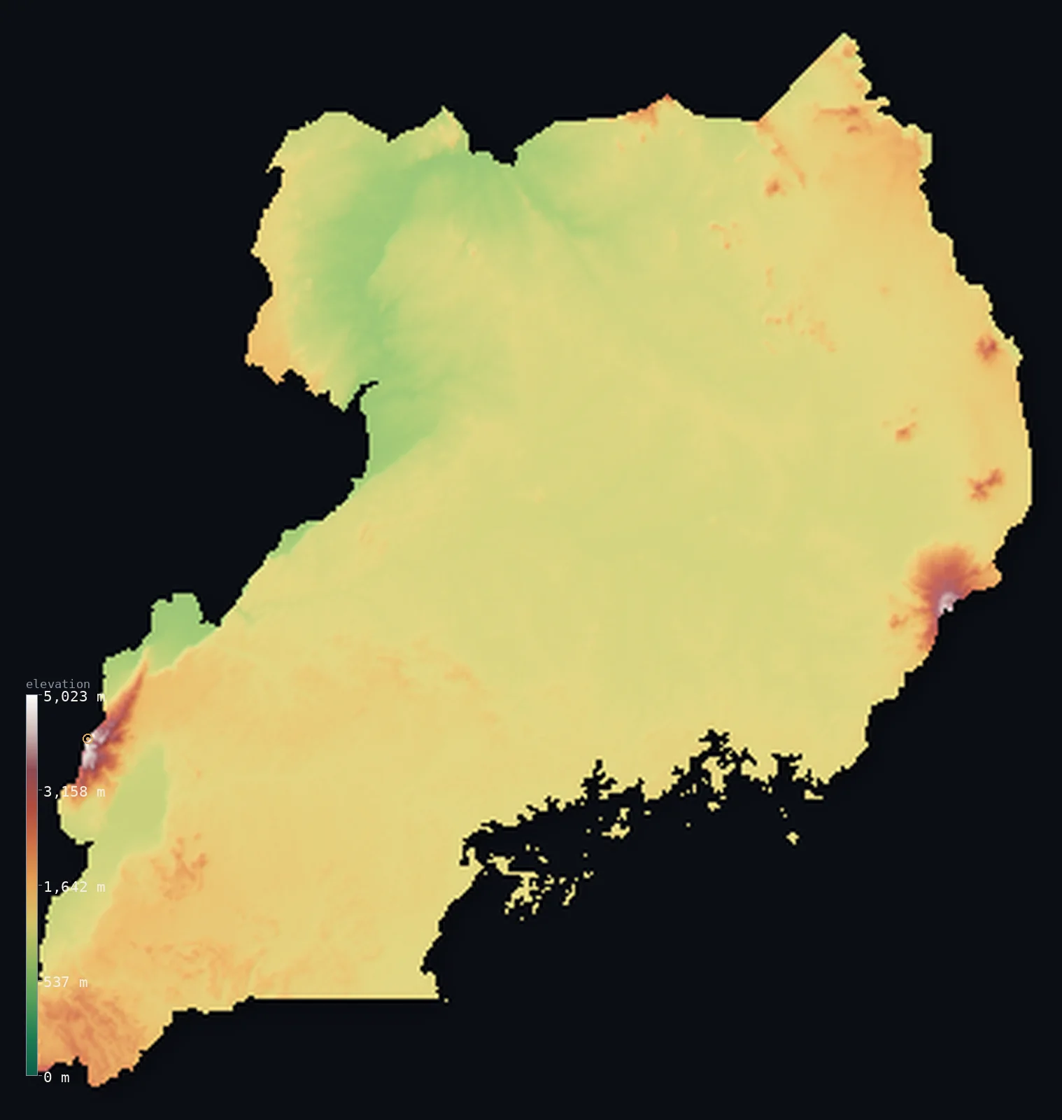
Uganda’s highest point is Margherita Peak (Mount Stanley) at 16,762 ft (5,109 m); its lowest is Albert Nile at 2,014 ft (614 m); the mean elevation is 3,822 ft (1,165 m).
Uganda is a high, green plateau on the equator, cradled between the two arms of the East African Rift. Most of the country is rolling tableland lying above 3,000 ft, well-watered and fertile, dropping to the shores of vast lakes — above all Lake Victoria, the largest lake in Africa, in the southeast. Along the western border, in the Albertine Rift, the land rises sharply to the Rwenzori Mountains, whose glaciated summit, Mount Stanley, reaches 16,762 ft (5,109 m) — the highest point in Uganda, shared with the Democratic Republic of the Congo. Volcanoes rise in the southwest, and at Jinja the White Nile begins its long journey north out of Lake Victoria.
- Highest point📚
- 16,762 ft5,109 m
- Uganda's highest point is Mount Stanley, whose summit Margherita Peak reaches 16,762 ft (5,109 m), in the Rwenzori Mountains on the western border with the Democratic Republic of the Congo — a glaciated massif shared between the two countries, its summit standing on the frontier, and the highest point of both. The Rwenzori, the fabled 'Mountains of the Moon,' carry some of the only permanent ice in Africa, high above the rift valley below. It rises far above the plateau that makes up most of Uganda.
- Lowest point📚
- 2,014 ft614 m
- Uganda's lowest point is on the Albert Nile in the northwest at about 2,014 ft (614 m) — still high above the sea, for landlocked Uganda is a high plateau country: even its lowest ground, where the Nile flows on toward South Sudan, stands well up. Uganda has no low country at all.
- Mean elevation⚙
- 3,822 ft1,165 m
- Computed from the GLO-30 model, Uganda's mean elevation is 3,822 ft (1,165 m) — a high figure for a country on the equator, and the sign of a land lifted bodily onto a plateau: green tableland above 1,000 m fills most of it, broken only by the great lake basins below and the Rwenzori's glaciers above, on the western rift.
- Median elevation⚙
- 3,635 ft1,108 m
- Half of Uganda lies above about 3,635 ft (1,108 m) — high, and barely different from the mean, because the plateau is so even: most of the country sits at much the same tableland height, with the lake shores the main low ground and the Rwenzori and the volcanoes the exceptional high.
- Elevation range📚
- 14,747 ft4,495 m
- Uganda's terrain climbs about 14,750 ft from bottom to top — but 'bottom' is the Albert Nile at 614 m, already high, and 'top' is Mount Stanley's glaciers at 5,109 m: the whole span sits between a high plateau and the rift's ice, with no true lowland anywhere in it.
- Above 1,000 m (3,281 ft)⚙
- 85%
- About 85% of Uganda rises above 1,000 m (3,281 ft) — which is to say most of the country, since Uganda is a high plateau throughout. The lower ground is confined to the lake basins and the Nile valleys; only a little of the country lies below.
- Above 2,000 m (6,562 ft)⚙
- 2%
- Roughly 2% of Uganda stands above 2,000 m (6,562 ft) — a small fraction, mainly the Rwenzori Mountains on the western border, the southwestern volcanoes, and Mount Elgon in the east, the country's highest ground.
- Official area📚
- 93,065 mi²241,038 km²
- Uganda covers about 93,100 sq mi (241,038 sq km) — a landlocked East African country on the equator, a high plateau ringed by the rift mountains and the great lakes (including Lake Victoria, Africa's largest), rising to the Rwenzori Mountains on the Congo border, and the source of the White Nile.
- Forest cover📚
- 12.4%
- About 12% of Uganda is forested — well-watered and green for equatorial Africa, with tropical forest in the west and around the lakes, montane forest on the Rwenzori and Elgon, and wooded savanna across the drier north.
Highest and lowest points
Uganda's highest point is Mount Stanley, whose summit Margherita Peak reaches 16,762 ft (5,109 m), in the Rwenzori Mountains on the western border with the Democratic Republic of the Congo. It is a glaciated massif — the Rwenzori, long known as the 'Mountains of the Moon,' hold some of the only permanent glaciers in Africa, though they are retreating fast. Margherita's summit stands on the frontier, and the peak is the highest point of both Uganda and the DRC. The Rwenzori rise abruptly from the Albertine Rift — the western branch of the East African Rift, which runs down Uganda's western edge in a line of mountains, rift lakes, and, in the southwest, the Virunga volcanoes (Uganda shares Mount Muhabura and others at the Rwanda-Congo tripoint). Far to the east stands another great massif, Mount Elgon, an old volcano on the Kenyan border. But the Rwenzori are Uganda's roof, glaciers on the equator above the plateau.
source ↗Uganda's lowest point is on the Albert Nile in the northwest, at about 2,014 ft (614 m) above sea level — where the White Nile, having left Lake Victoria, flows north toward South Sudan and the Sudd. Even this, the lowest ground in the country, stands well above 600 m: landlocked Uganda is a high plateau throughout, with no truly low land. The country is a land of water as much as height — cradling parts of Lake Victoria (Africa's largest lake), Lake Albert, Lake Edward, and Lake Kyoga, and giving rise to the White Nile, which begins its journey to the Mediterranean here, at Jinja on the shore of Lake Victoria.
source ↗Uganda at a glance
The Rwenzori are the highest non-volcanic mountains in Africa - an uplifted block of ancient rock, not a volcano like Kilimanjaro or Kenya.
source ↗Margherita Peak carries glaciers almost on the Equator, but they lost nearly a third of their area between 2020 and 2024.
source ↗The snows of the Rwenzori were linked by ancient geographers to Ptolemy's legendary 'Mountains of the Moon', a source of the Nile.
source ↗Even Uganda's lowest point, the Albert Nile, lies over 600 m above sea level - the country is landlocked and high.
source ↗Mount Elgon in the east has one of the largest volcanic calderas of any mountain on Earth.
source ↗
Elevation profile of Uganda
The largest share of land, 77%, falls in the 1,000–1,500 m band, and 100% of the territory lies above 500 m (1,640 ft).
- 500–1,000 m15%
- 1,000–2,000 m83%
- above 2,000 m (6,562 ft)2%
Highest peaks of Uganda
| Peak | Elevation | Range | Note |
|---|---|---|---|
| Margherita Peak (Mount Stanley)↗ | 16,762 ft5,109 m | Rwenzori Mountains | Highest point of Uganda and the Congo, third-highest in Africa, a glaciated peak on the shared border. |
| Mount Speke↗ | 16,043 ft4,890 m | Rwenzori Mountains | The second-highest massif of the Rwenzori, north of Mount Stanley. |
| Mount Baker↗ | 15,889 ft4,843 m | Rwenzori Mountains | A third high massif of the Rwenzori, enclosing the Bujuku valley with Stanley and Speke. |
| Mount Elgon (Wagagai)↗ | 14,177 ft4,321 m | Mount Elgon | An extinct volcano on the Kenyan border in the east, with one of the world's largest calderas. |
| Mount Muhavura↗ | 13,540 ft4,127 m | Virunga Mountains | A cone-shaped volcano of the Virunga range in the southwest, on the Rwandan border. |
Uganda: the plateau and the lakes, the western rift, and the eastern highlands
The central plateau and the lakes
Most of Uganda is a high, rolling plateau — well-watered green tableland above 1,000 m, dropping to the shores of great lakes: Victoria (Africa's largest) in the southeast, and Kyoga in the centre. The fertile, populous heart of the country, a land of hills and water.
The western rift and mountains
Along the western border runs the Albertine Rift — the rift lakes Albert and Edward, and, rising sharply above them, the glaciated Rwenzori Mountains (holding Mount Stanley, the high point, shared with the DRC) and, in the southwest, the Virunga volcanoes. The country's highest and most dramatic ground.
The eastern highlands and the northern plains
In the east rises Mount Elgon, a vast old volcano on the Kenyan border, while across the north the plateau is lower, drier, and flatter — wooded savanna plains toward South Sudan. The higher volcanic east and the lower savanna north.
How to read this map
Color shows elevation; the raised relief shows real terrain. On this map Uganda reads as a high plateau ringed by mountains and lakes — broad mid-to-high-toned tableland filling most of the country, the dark flat sheets of Lake Victoria and the other lakes cut into it, and the sharp high browns and whites of the Rwenzori on the western Congo border (highest at Mount Stanley), the southwestern volcanoes, and Mount Elgon in the east.
The 3D relief is the actual GLO-30 elevation data, exaggerated vertically so the plateau, the lakes, and the rift mountains all show; the ×N relief slider controls how much. Tap anywhere to read that point's exact elevation.
City elevations in Uganda
Uganda's cities cluster on the plateau and around Lake Victoria — Kampala, the capital, on the lake's northern shore, Njeru nearby at the source of the Nile, Gulu in the north, Mbarara in the southwest, and Mbale by Mount Elgon in the east. Most lie high, on the plateau.
| City | Population | Elevation |
|---|---|---|
| Kampalacapitalthe capital, on the northern shore of Lake Victoria ↗ | 1,680,600 | 3,993 ft1,217 m |
| Mbararain the southwest ↗ | 221,300 | 4,672 ft1,424 m |
| Njeruat the source of the White Nile, where it leaves Lake Victoria ↗ | 178,800 | 3,770 ft1,149 m |
| Guluin the northern plains ↗ | 177,400 | 3,612 ft1,101 m |
| Hoimain the west, near Lake Albert ↗ | 122,700 | 3,711 ft1,131 m |
| Mubendeon the central plateau ↗ | 121,600 | 4,304 ft1,312 m |
| Lirain the northern plains ↗ | 119,323 | 3,596 ft1,096 m |
| Masakain the south, near Lake Victoria ↗ | 116,600 | 4,213 ft1,284 m |
| Kasesein the west, below the Rwenzori Mountains ↗ | 115,400 | 3,245 ft989 m |
| Mbalein the east, by Mount Elgon ↗ | 111,300 | 3,681 ft1,122 m |
Elevation sampled at each city centre from the Copernicus GLO-30 model. Cities and population from GeoNames (CC-BY 4.0).
Uganda in comparison
Uganda's terrain rises 14,747 ft (4,495 m) from Albert Nile (2,014 ft (614 m)) to Margherita Peak (Mount Stanley) — about 51% of the height of Mount Everest, the world's highest point at 29,032 ft (8,849 m).
- Democratic Republic of the Congo's mean elevation is 2,244 ft — 1,578 ft lower; its high point, Margherita Peak (Mount Stanley), reaches 16,762 ft (5,109 m), 0 ft above. Democratic Republic of the Congo elevation map →
- Rwanda's mean elevation is 5,610 ft — 1,788 ft higher; its high point, Mount Karisimbi, reaches 14,787 ft (4,507 m), 1,975 ft below. Rwanda elevation map →
- Kenya's mean elevation is 2,575 ft — 1,247 ft lower; its high point, Mount Kenya (Batian), reaches 17,057 ft (5,199 m), 295 ft above. Kenya elevation map →
- Tanzania's mean elevation is 3,340 ft — 482 ft lower; its high point, Kilimanjaro (Uhuru Peak), reaches 19,341 ft (5,895 m), 2,579 ft above. Tanzania elevation map →
Frequently asked questions
What is the highest point in Uganda?
- Mount Stanley (Margherita Peak), 16,762 ft (5,109 m), in the Rwenzori Mountains on the Congo border — a glaciated massif shared with the DRC, the highest point of both, holding some of the only permanent ice in Africa.
What is the lowest point in Uganda?
- On the Albert Nile in the northwest, at about 2,014 ft (614 m) — still high, as Uganda is a plateau throughout with no truly low ground.
What is the average elevation of Uganda?
- Computed from the Copernicus GLO-30 model, the area-weighted mean is 3,822 ft (1,165 m) — high, because Uganda is essentially a high equatorial plateau, dropping to the great lakes and rising to the Rwenzori on the west.
What are the Rwenzori Mountains?
- A glaciated range on the Uganda-DRC border, holding Mount Stanley, the highest point of both countries — the fabled 'Mountains of the Moon,' carrying some of the only permanent glaciers in Africa, almost on the equator.
Where does the White Nile start?
- At Jinja in Uganda, where it flows out of Lake Victoria — the beginning of the White Nile's long journey north to join the Blue Nile and reach the Mediterranean.
Is this a topographic, relief, contour, or elevation map of Uganda?
- They describe the same thing — terrain height. This page renders the country's actual elevation surface in interactive 3D and reports the statistics computed from it.
About this map
The terrain is rendered from the Copernicus GLO-30 digital elevation model (ESA), masked to the UGA-ADM0 boundary from geoBoundaries (gbOpen). Elevation statistics are computed directly from the model; peak names and researched facts are sourced and cited. See the methodology for the full pipeline.
Our area-weighted mean, computed from the Copernicus GLO-30 model, is 3,822 ft (1,165 m); the figure commonly cited elsewhere is 3,894 ft (1,187 m) (CIA World Factbook). Most of Uganda is a high plateau above 1,000 m, edged by rift valleys and mountains and dropping only along the Nile in the north, so its mean elevation is high; the page reports the area-weighted figure computed from the Copernicus GLO-30 model.
Surveyed national figures: official area · forest cover · high point.
Rendered from Copernicus GLO-30 (ESA, 2021 release), boundaries from geoBoundaries. Generated 2026-07-08.
Bordering countries · 5
Uganda shares a land border with these countries — open any one to compare its terrain and highest point.