Rwanda Elevation Map — Topographic & 3D Terrain
Explore the terrain of Rwanda in interactive 3D, built from Copernicus GLO-30 satellite elevation data — the 'land of a thousand hills,' a high, steep country on the Nile-Congo divide. Drag to rotate, scroll to zoom, and tap any point to read its elevation.
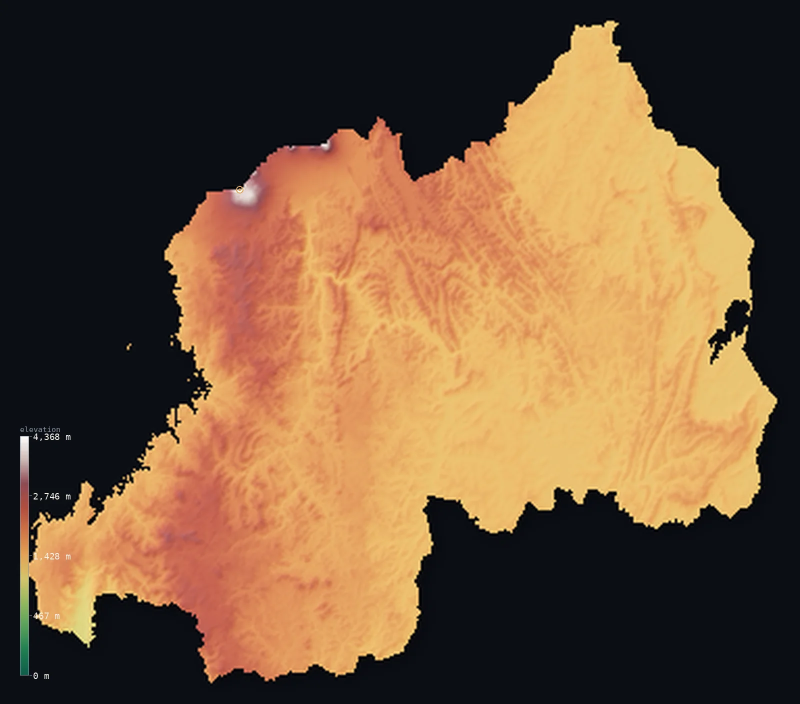
Rwanda’s highest point is Mount Karisimbi at 14,787 ft (4,507 m); its lowest is Ruzizi River at 3,117 ft (950 m); the mean elevation is 5,610 ft (1,710 m).
Rwanda is a small, high, mountainous country — the 'land of a thousand hills.' Almost all of it is steep, green highland: a landscape of countless hills and terraced ridges lying mostly above 4,500 ft, cut by valleys and rising toward the west. Down the western side runs the Congo-Nile Divide, a high crest separating the waters that flow west to the Congo from those that flow east to the Nile, dropping steeply to Lake Kivu on the Congo border. In the northwest rise the Virunga Mountains, a chain of volcanoes holding the country's highest point, Mount Karisimbi, at 14,787 ft (4,507 m). It is one of the most densely populated and highest-lying countries in Africa.
- Highest point📚
- 14,787 ft4,507 m
- Rwanda's highest point is Mount Karisimbi at 14,787 ft (4,507 m), a volcano in the Virunga Mountains in the northwest, on the border with the Democratic Republic of the Congo — the highest of the chain of great volcanoes (shared between Rwanda, the DRC, and Uganda) that rises above the western highlands. Snow sometimes dusts its summit, high above the surrounding hills, the roof of a country that is high throughout.
- Lowest point📚
- 3,117 ft950 m
- Rwanda's lowest point is on the Ruzizi River in the southwest at about 3,117 ft (950 m) — where the river drains Lake Kivu southward toward Lake Tanganyika. Even this, the lowest ground in Rwanda, lies well above 900 m: the whole country is high, without any true lowland.
- Mean elevation⚙
- 5,610 ft1,710 m
- Computed from the GLO-30 model, Rwanda's mean elevation is 5,610 ft (1,710 m) — one of the highest national averages in Africa, and no wonder: Rwanda is almost nothing but steep hill country, thousands of ridges lying above 1,400 m, rising west to the Congo-Nile Divide and the Virunga volcanoes, with no low ground to pull it down.
- Median elevation⚙
- 5,308 ft1,618 m
- Half of Rwanda lies above about 5,308 ft (1,618 m) — a high median, though the mean rides higher still, lifted by the Virunga volcanoes and the western crest: below those few great heights, the country is a uniform sea of steep hills, all at much the same elevation.
- Elevation range📚
- 11,670 ft3,557 m
- Rwanda's relief spans about 11,670 ft, from the Ruzizi at 950 m to Karisimbi's 4,507 m — yet even the floor of that range is high hill country: Rwanda climbs from high hills to volcanic summits and never touches lowland at all.
- Above 1,000 m (3,281 ft)⚙
- >99%
- Virtually all of Rwanda — >99% — rises above 1,000 m (3,281 ft), since it is a high country throughout. The typical hill lies well above that; only the deepest valleys approach it.
- Above 2,000 m (6,562 ft)⚙
- 20%
- Roughly 20% of Rwanda stands above 2,000 m (6,562 ft) — a large part of the country, the higher hills and the western highlands, rising to the Virunga volcanoes and the Congo-Nile Divide.
- Official area📚
- 10,169 mi²26,338 km²
- Rwanda covers about 10,200 sq mi (26,338 sq km) — a small, landlocked, high, and mountainous country in the Great Lakes region of central-eastern Africa, the 'land of a thousand hills,' astride the Congo-Nile Divide, rising to the Virunga volcanoes and Mount Karisimbi.
- Forest cover📚
- 19.7%
- About 20% of Rwanda is forested — montane rainforest in the west (Nyungwe), bamboo and forest on the Virunga volcanoes, though much of the country's hills are intensively terraced and farmed, one of the most cultivated landscapes in Africa.
Highest and lowest points
Rwanda's highest point is Mount Karisimbi, 14,787 ft (4,507 m), a volcano in the Virunga Mountains of the northwest, on the border with the Democratic Republic of the Congo. It is the highest of the Virungas — a chain of eight great volcanoes rising at the meeting point of Rwanda, the DRC, and Uganda, some still active, others long dormant — that stand above Rwanda's western highlands and shelter the mountain gorillas. Karisimbi's summit, occasionally dusted with snow, is Rwanda's roof, though it is not Rwanda's alone: the higher Margherita Peak of the Rwenzori, to the north, is the summit of the DRC and Uganda, while Karisimbi is Rwanda's. Nearby, the volcano Muhabura (shared with Uganda) rises on the frontier. Below the volcanoes, Rwanda falls away in endless terraced hills — the 'thousand hills' that give the country its name.
source ↗Rwanda's lowest point is on the Ruzizi River in the southwest, at about 3,117 ft (950 m) above sea level — where the river carries the outflow of Lake Kivu down toward Lake Tanganyika. Even this, the lowest ground in the whole country, stands well above 900 m: Rwanda is high from end to end, a land without lowland. Down its western side runs the Congo-Nile Divide, a high mountain crest that parts the country's waters — those on the west draining to Lake Kivu and the Congo, and so to the Atlantic; those on the east to the Nyabarongo and the Kagera, headwaters of the White Nile, and so to the Mediterranean. Rwanda is a high watershed as well as a land of hills.
source ↗Rwanda at a glance
Mount Karisimbi (4,507 m) is the highest of the eight Virunga volcanoes and the highest point in Rwanda; its name means 'white shell', for its often hail-capped summit.
source ↗Rwanda's lowest point is about 950 m above sea level - the land never comes near the sea.
source ↗The Congo-Nile divide runs through Rwanda's western highlands, splitting rivers between the Atlantic-bound Congo and the Mediterranean-bound Nile.
source ↗The Virunga volcanoes shelter roughly a third of the world's surviving mountain gorillas.
source ↗Lake Kivu, on the western border, is one of Africa's deepest lakes and holds vast amounts of dissolved gas.
source ↗
Elevation profile of Rwanda
The largest share of land, 35%, falls in the 1,250–1,500 m band, and 100% of the territory lies above 500 m (1,640 ft).
- 500–1,000 m<1%
- 1,000–2,000 m80%
- above 2,000 m (6,562 ft)20%
Highest peaks of Rwanda
| Peak | Elevation | Range | Note |
|---|---|---|---|
| Mount Karisimbi↗ | 14,787 ft4,507 m | Virunga Mountains | Highest point of Rwanda and of the Virunga chain, a dormant volcano on the Congo border. |
| Mount Muhabura↗ | 13,540 ft4,127 m | Virunga Mountains | A symmetrical volcanic cone on the Rwanda-Uganda border in the Virunga chain. |
| Mount Bisoke↗ | 12,175 ft3,711 m | Virunga Mountains | An extinct volcano with a summit crater lake, on the Congo border in Volcanoes National Park. |
| Mount Sabyinyo↗ | 12,037 ft3,669 m | Virunga Mountains | An eroded volcano at the tripoint of Rwanda, Uganda and the Congo. |
| Mount Bigugu↗ | 9,678 ft2,950 m | Nyungwe (Congo-Nile divide) | The high point of Nyungwe Forest in the southwest, the highest ground outside the Virungas. |
Rwanda: the thousand hills, the Congo-Nile Divide, and the Virunga volcanoes
The central and eastern hills
Most of Rwanda is a land of a thousand hills — steep, green, terraced ridges and valleys covering the centre and east of the country, lying mostly above 1,400 m and lower toward the east. The intensively farmed, densely peopled heart of the country.
The Congo-Nile Divide and the west
Down the western side runs the Congo-Nile Divide — a high mountain crest, forested (Nyungwe in the south), that separates the country's watersheds and drops steeply to Lake Kivu on the Congo border. The highest, wettest, most forested spine of the country.
The Virunga volcanoes (the northwest)
In the northwest rise the Virunga Mountains — a chain of great volcanoes, holding Mount Karisimbi (the high point) and shared with the DRC and Uganda, home to the mountain gorillas. The country's highest and most dramatic ground, volcanic and steep above the hills.
How to read this map
Color shows elevation; the raised relief shows real terrain. On this map Rwanda reads as a uniformly high, hilly country — a dense texture of high-toned ridges and valleys covering nearly all of it (the 'thousand hills'), rising along the western Congo-Nile Divide and, sharply, to the Virunga volcanoes in the northwest (highest at Karisimbi), with Lake Kivu's dark sheet on the western border.
With the whole country high and steep, the 3D relief shows a landscape of endless hills; the ×N relief slider controls how much. Tap anywhere to read that point's exact elevation.
City elevations in Rwanda
Rwanda's cities sit among the hills — Kigali, the capital, on the high central ridges, Butare (Huye) in the south, Gisenyi on Lake Kivu in the west, and Musanze (Ruhengeri) below the Virunga volcanoes in the northwest. All lie high, in the hill country.
| City | Population | Elevation |
|---|---|---|
| Kigalicapitalthe capital, on the central hills ↗ | 1,132,686 | 5,062 ft1,543 m |
| Gisenyion Lake Kivu, on the Congo border ↗ | 172,357 | 4,820 ft1,469 m |
| Musanzebelow the Virunga volcanoes in the northwest ↗ | 153,368 | 6,063 ft1,848 m |
| Nyagatarein the northeast ↗ | 100,000 | 4,403 ft1,342 m |
| Gitaramain the centre ↗ | 87,613 | 6,010 ft1,832 m |
| Butarein the south ↗ | 62,823 | 5,778 ft1,761 m |
| Kibuyeon Lake Kivu, in the west ↗ | 48,024 | 4,882 ft1,488 m |
| Rwamaganain the east ↗ | 47,203 | 5,033 ft1,534 m |
| Kibungoin the southeast ↗ | 46,240 | 5,289 ft1,612 m |
| Cyanguguin the southwest, on Lake Kivu ↗ | 43,866 | 5,210 ft1,588 m |
Elevation sampled at each city centre from the Copernicus GLO-30 model. Cities and population from GeoNames (CC-BY 4.0).
Rwanda in comparison
Rwanda's terrain rises 11,670 ft (3,557 m) from Ruzizi River (3,117 ft (950 m)) to Mount Karisimbi — about 40% of the height of Mount Everest, the world's highest point at 29,032 ft (8,849 m).
- Burundi's mean elevation is 5,125 ft — 486 ft lower; its high point, Mount Heha, reaches 8,806 ft (2,684 m), 5,981 ft below. Burundi elevation map →
- Democratic Republic of the Congo's mean elevation is 2,244 ft — 3,366 ft lower; its high point, Margherita Peak (Mount Stanley), reaches 16,762 ft (5,109 m), 1,975 ft above. Democratic Republic of the Congo elevation map →
- Uganda's mean elevation is 3,822 ft — 1,788 ft lower; its high point, Margherita Peak (Mount Stanley), reaches 16,762 ft (5,109 m), 1,975 ft above. Uganda elevation map →
- Tanzania's mean elevation is 3,340 ft — 2,270 ft lower; its high point, Kilimanjaro (Uhuru Peak), reaches 19,341 ft (5,895 m), 4,554 ft above. Tanzania elevation map →
Frequently asked questions
What is the highest point in Rwanda?
- Mount Karisimbi, 14,787 ft (4,507 m), a volcano in the Virunga Mountains on the Congo border — the highest of the volcano chain shared with the DRC and Uganda.
What is the lowest point in Rwanda?
- On the Ruzizi River in the southwest, at about 3,117 ft (950 m) — and even this is high, as Rwanda is a high country throughout with no lowland.
What is the average elevation of Rwanda?
- Computed from the Copernicus GLO-30 model, the area-weighted mean is 5,610 ft (1,710 m) — high, because Rwanda is almost entirely steep, high hill country, the 'land of a thousand hills.'
Why is Rwanda called the 'land of a thousand hills'?
- Because almost the whole country is steep, high hill country — a landscape of countless terraced ridges and valleys, one of the most mountainous and densely populated in Africa.
What is the Congo-Nile Divide?
- A high mountain crest down western Rwanda that separates the country's rivers — those flowing west to the Congo and the Atlantic from those flowing east to the Nile and the Mediterranean.
Is this a topographic, relief, contour, or elevation map of Rwanda?
- They describe the same thing — terrain height. This page renders the country's actual elevation surface in interactive 3D and reports the statistics computed from it.
About this map
The terrain is rendered from the Copernicus GLO-30 digital elevation model (ESA), masked to the RWA-ADM0 boundary from geoBoundaries (gbOpen). Elevation statistics are computed directly from the model; peak names and researched facts are sourced and cited. See the methodology for the full pipeline.
Our area-weighted mean, computed from the Copernicus GLO-30 model, is 5,610 ft (1,710 m); the figure commonly cited elsewhere is 5,243 ft (1,598 m) (CIA World Factbook). The CIA-cited ~1,598 m sits below the 1,710 m computed here from GLO-30; sampling every steep ridge, the model finds Rwanda even higher on average than the round cited figure — fitting for a country with essentially no low ground to bring the mean down.
Surveyed national figures: official area · forest cover · high point.
Rendered from Copernicus GLO-30 (ESA, 2021 release), boundaries from geoBoundaries. Generated 2026-06-26.
Bordering countries · 4
Rwanda shares a land border with these countries — open any one to compare its terrain and highest point.