Eritrea Elevation Map — Topographic & 3D Terrain
Explore the terrain of Eritrea in interactive 3D, built from Copernicus GLO-30 satellite elevation data — a Red Sea coast, a high central plateau, and the deep, hot Danakil Depression. Drag to rotate, scroll to zoom, and tap any point to read its elevation.
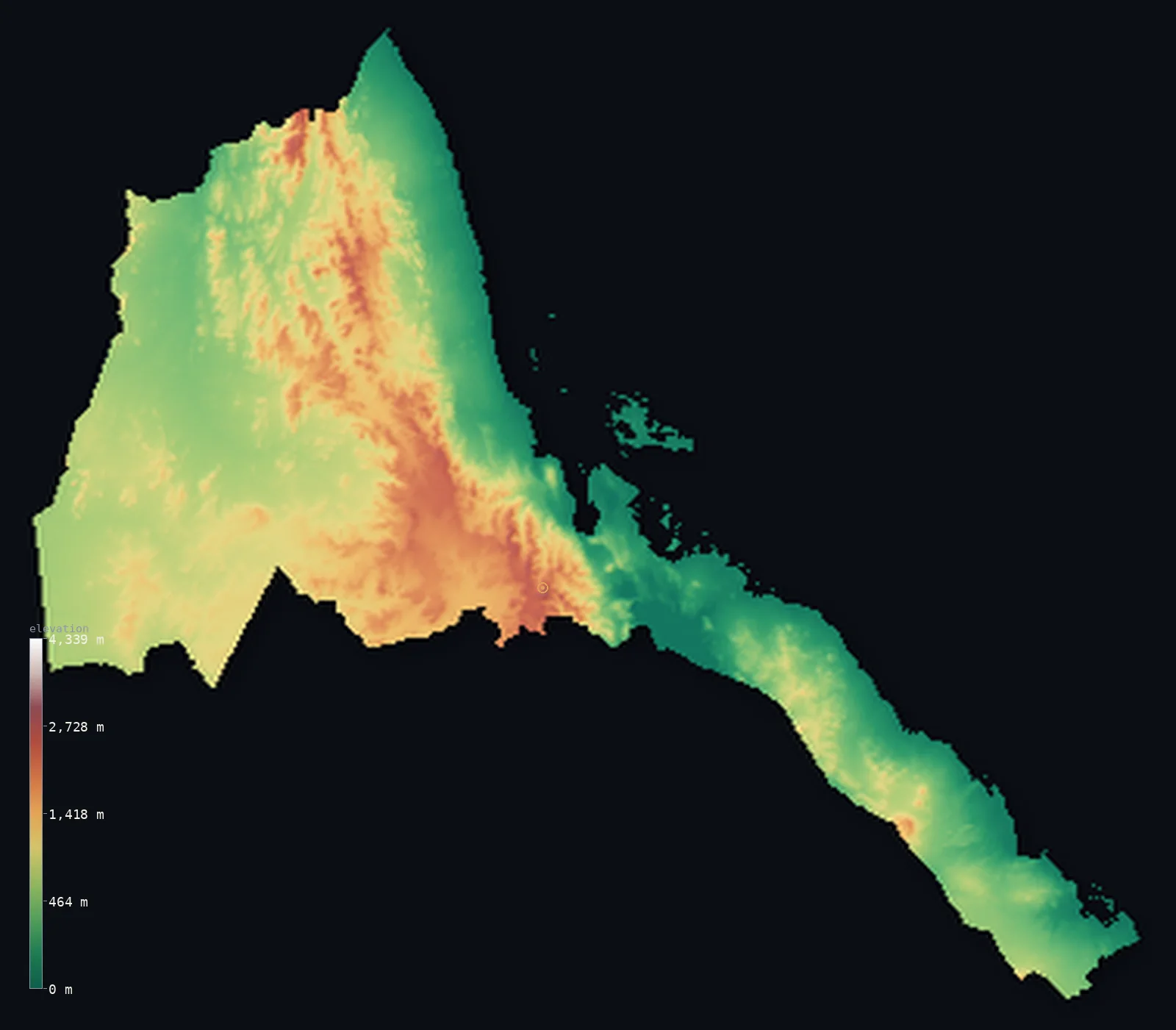
Eritrea’s highest point is Emba Soira at 9,902 ft (3,018 m); its lowest is Danakil Depression (near Kulul / Kobar Sink) at −246 ft (−75 m); the mean elevation is 2,507 ft (764 m).
Eritrea rises from one of the hottest, lowest places on Earth to a high central plateau. Along the Red Sea runs a low, hot coastal plain, and in the southeast it drops below sea level into the Danakil Depression — part of the Afar region, a scorching rift basin among the lowest dry land on the planet. Inland, the land climbs steeply to the Eritrean Highlands, a high plateau lying mostly above 6,000 ft that forms the northern end of the great Ethiopian highland massif, rising to the country's highest point, Emba Soira, at 9,902 ft (3,018 m). West of the highlands the land falls again to lower savanna plains toward Sudan.
- Highest point📚
- 9,902 ft3,018 m
- Eritrea's highest point is Emba Soira at 9,902 ft (3,018 m), in the Eritrean Highlands south of the capital, Asmara — the high point of the central plateau that forms the northern end of the Ethiopian highland massif. It rises from high tableland, cool and elevated, far above both the Red Sea coast and the Danakil below.
- Lowest point📚
- −246 ft−75 m
- Eritrea's lowest point is in the Danakil Depression, at about 246 ft (75 m) below sea level — a scorching rift basin in the southeast, part of the Afar region, among the lowest and hottest dry land anywhere on Earth. It is the deep floor of the Great Rift Valley, where the Earth's crust is pulling apart.
- Mean elevation⚙
- 2,507 ft764 m
- Computed from the GLO-30 model, Eritrea's mean elevation is 2,507 ft (764 m) — a middling figure that conceals a country of extremes: a high central plateau above 1,800 m set against a low Red Sea coast and, below even the sea, the Danakil, with the western lowlands between.
- Median elevation⚙
- 2,162 ft659 m
- Half of Eritrea lies below about 2,162 ft (659 m), well under the mean — the plateau is high, but the low coast, the western lowlands, and the below-sea Danakil hold enough low ground that the typical point sits below the elevated centre.
- Elevation range📚
- 10,148 ft3,093 m
- Eritrea's terrain spans about 10,150 ft — from 75 m below sea level in the Danakil, among the lowest dry land on Earth, up to Emba Soira at 3,018 m — a huge range packed into a small country, crossing one of the most tectonically active regions on the planet.
- Above 1,000 m (3,281 ft)⚙
- 28%
- About 28% of Eritrea rises above 1,000 m (3,281 ft) — chiefly the Eritrean Highlands, the central plateau that forms the northern end of the Ethiopian massif. The Red Sea coastal plain, the western lowlands, and the Danakil lie lower.
- Above 2,000 m (6,562 ft)⚙
- 4%
- Roughly 4% of Eritrea stands above 2,000 m (6,562 ft) — the higher parts of the central plateau around Asmara and Emba Soira, the country's high heart.
- Official area📚
- 45,406 mi²117,600 km²
- Eritrea covers about 45,400 sq mi (117,600 sq km) — a country in the Horn of Africa on the Red Sea, with a low, hot coastal plain and the below-sea Danakil Depression, a high central plateau (the northern Ethiopian highlands), and lower western plains toward Sudan.
- Forest cover📚
- 14.8%
- About 15% of Eritrea is forested — very little, as most of the country is dry: semi-desert on the coast and in the Danakil, and dry grassland and scrub on the plateau and western lowlands, with remnant woodland on the wetter highland slopes.
Highest and lowest points
Eritrea's highest point is Emba Soira, 9,902 ft (3,018 m), in the Eritrean Highlands to the south of the capital, Asmara. These highlands — a high plateau lying mostly above 1,800 m — form the northern end of the great Ethiopian highland massif, and are the cool, fertile, densely settled heart of the country, holding Asmara and most of its people. Emba Soira is their summit. It rises far above the two low extremes that flank the plateau: the hot Red Sea coastal plain to the east, and, beyond it, the Danakil Depression, which drops below sea level. In few places on Earth does such high ground stand so close to such deep — Eritrea spans from a below-sea rift basin to a high mountain plateau in a short distance.
source ↗Eritrea's lowest point is in the Danakil Depression, at about 246 ft (75 m) below sea level — a vast, scorching basin in the southeast, part of the Afar Triangle, among the lowest and hottest places on the face of the Earth. Here the crust of the planet is splitting apart, where three tectonic rifts meet, and the land has sunk far below the sea; salt flats, lava, and volcanoes mark the floor of the depression. (The very deepest and most famous of the Danakil, around Dallol, lies just across the border in Ethiopia, but Eritrea holds its northern reaches; the elevation model reads its Eritrean floor a little lower still, to about −124 m.) From this extraordinary low the land rises steeply northwestward to the Eritrean Highlands — so that a small country holds both some of the lowest dry land on Earth and a high mountain plateau.
source ↗Eritrea at a glance
Eritrea runs from the Danakil Depression - below sea level and among the hottest places on Earth - up to the cool plateau of Emba Soira at 3,018 m, where winter nights drop below freezing.
source ↗The Danakil Depression in southeastern Eritrea is part of the Afar Triangle, a triple junction where three tectonic plates are slowly pulling apart, studded with active volcanoes.
source ↗Eritrea's highlands are carved into flat-topped mountains called ambas, separated by deep gorges - a distinctive landform of the Horn of Africa highlands.
source ↗More than 120 islands of the Dahlak Archipelago lie off Eritrea's Red Sea coast, but only a couple are inhabited.
source ↗The Danakil volcano Dubbi produced one of the largest eruptions recorded in Africa, in 1861, and nearby Nabro erupted as recently as 2011.
source ↗The capital, Asmara, sits right on the edge of the escarpment at about 2,325 m, where the highlands plunge toward the coast - giving it a cool climate close to the tropical Red Sea.
source ↗
Elevation profile of Eritrea
The largest share of land, 18%, falls in the 0–200 m band, and 63% of the territory lies above 500 m (1,640 ft).
- below 500 m (1,640 ft)37%
- 500–1,000 m35%
- 1,000–2,000 m24%
- above 2,000 m (6,562 ft)4%
Highest peaks of Eritrea
| Peak | Elevation | Range | Note |
|---|---|---|---|
| Emba Soira↗ | 9,902 ft3,018 m | Eritrean Highlands | Highest point of Eritrea, in the central highland plateau near Senafe. |
| Nabro↗ | 7,277 ft2,218 m | Danakil (Afar) - southeast | A stratovolcano in the southeastern Danakil that erupted in 2011, near the Ethiopian border. |
| Dubbi↗ | 5,331 ft1,625 m | Danakil (Afar) - southeast | A coastal Danakil volcano whose 1861 eruption was one of the largest recorded in Africa. |
Eritrea: the central highlands, the Red Sea coast and the Danakil, and the western lowlands
The central highlands
The heart of Eritrea is a high plateau — the Eritrean Highlands, lying mostly above 1,800 m, the northern end of the Ethiopian massif, holding the capital Asmara and rising to Emba Soira (the high point). Cool, fertile, and densely settled, it is the country's high, populous core.
The Red Sea coast and the Danakil
East of the highlands the land drops to a low, hot coastal plain along the Red Sea (with the port of Massawa and the Dahlak islands), and, in the southeast, plunges below sea level into the Danakil Depression — a scorching rift basin among the lowest dry land on Earth. The country's hot, low, eastern extreme.
The western lowlands
West of the highlands the land falls to lower plains — dry savanna and scrub sloping toward the Sudanese border and the Barka and Gash river valleys. The country's lower, drier western side.
How to read this map
Color shows elevation; the raised relief shows real terrain. On this map Eritrea reads as a high central plateau between low flanks — the mid-to-high browns of the Eritrean Highlands running through the centre (highest at Emba Soira, near Asmara), dropping east to the low Red Sea coast and the deep Danakil Depression (shown at its below-sea low), and falling west to the lower Sudanese-border plains.
The 3D relief is the actual GLO-30 elevation data, exaggerated vertically so the high plateau and the low coast and depression all show; the ×N relief slider controls how much. Tap anywhere to read that point's exact elevation.
City elevations in Eritrea
Eritrea's cities centre on the plateau and the coast — Asmara, the capital, high on the central highlands, Keren in the highlands to the northwest, and the Red Sea ports of Massawa and Assab on the coast. The high plateau holds the capital; the coast holds the ports.
| City | Population | Elevation |
|---|---|---|
| Asmaracapitalthe capital, high on the central plateau ↗ | 563,930 | 7,657 ft2,334 m |
| Kerenin the northwestern highlands ↗ | 74,800 | 4,583 ft1,397 m |
| Himorain the western lowlands, toward Sudan ↗ | 46,100 | 1,909 ft582 m |
| Massawaa Red Sea port, on the coast ↗ | 23,100 | 16 ft5 m |
| Assaba Red Sea port in the far southeast ↗ | 21,300 | 56 ft17 m |
| Barentuin the western lowlands ↗ | 15,891 | 3,301 ft1,006 m |
| Adi Keyhin the southern highlands ↗ | 13,061 | 7,844 ft2,391 m |
| Eddon the Red Sea coast in the southeast ↗ | 11,259 | 13 ft4 m |
| Teseneyin the west, near the Sudanese border ↗ | 3,753 | 1,949 ft594 m |
| Mai-Mnein the central highlands ↗ | 0 | 6,047 ft1,843 m |
Elevation sampled at each city centre from the Copernicus GLO-30 model. Cities and population from GeoNames (CC-BY 4.0).
Eritrea in comparison
Eritrea's terrain rises 10,148 ft (3,093 m) from Danakil Depression (near Kulul / Kobar Sink), 246 ft (75 m) below sea level to Emba Soira — about 35% of the height of Mount Everest, the world's highest point at 29,032 ft (8,849 m).
- Ethiopia's mean elevation is 4,111 ft — 1,604 ft higher; its high point, Ras Dashen, reaches 14,928 ft (4,550 m), 5,026 ft above. Ethiopia elevation map →
- Djibouti's mean elevation is 1,467 ft — 1,040 ft lower; its high point, Mousa Ali, reaches 6,654 ft (2,028 m), 3,248 ft below. Djibouti elevation map →
- Sudan's mean elevation is 1,736 ft — 771 ft lower; its high point, Deriba Caldera (Jebel Marra), reaches 9,980 ft (3,042 m), 79 ft above. Sudan elevation map →
- Somalia's mean elevation is 1,375 ft — 1,132 ft lower; its high point, Mount Shimbiris, reaches 8,071 ft (2,460 m), 1,831 ft below. Somalia elevation map →
Frequently asked questions
What is the highest point in Eritrea?
- Emba Soira, 9,902 ft (3,018 m), in the Eritrean Highlands south of Asmara — the high point of the central plateau, the northern end of the Ethiopian massif.
What is the lowest point in Eritrea?
- The Danakil Depression, at about 246 ft (75 m) below sea level — a scorching rift basin in the southeast, among the lowest and hottest dry land on Earth.
What is the average elevation of Eritrea?
- Computed from the Copernicus GLO-30 model, the area-weighted mean is 2,507 ft (764 m) — moderate, averaging the high central plateau against the low Red Sea coast and the below-sea Danakil Depression.
What is the Danakil Depression?
- A vast, scorching rift basin in southeastern Eritrea (and beyond into Ethiopia), dropping below sea level — among the lowest and hottest places on Earth, where three tectonic rifts meet and the crust is splitting apart.
Does Eritrea have land below sea level?
- Yes — the Danakil Depression in the southeast drops to about 75 m below sea level, among the lowest dry land on the planet, even as the central plateau rises above 3,000 m.
Is this a topographic, relief, contour, or elevation map of Eritrea?
- They describe the same thing — terrain height. This page renders the country's actual elevation surface in interactive 3D and reports the statistics computed from it.
About this map
The terrain is rendered from the Copernicus GLO-30 digital elevation model (ESA), masked to the ERI-ADM0 boundary from geoBoundaries (gbOpen). Elevation statistics are computed directly from the model; peak names and researched facts are sourced and cited. See the methodology for the full pipeline.
Our area-weighted mean, computed from the Copernicus GLO-30 model, is 2,507 ft (764 m); no authority publishes a mean elevation (the CIA World Factbook). No standard reference publishes a mean elevation for Eritrea; the figure here is the area-weighted value computed from the Copernicus GLO-30 model — a middling average that, for this country, hides more than it tells, spanning from the below-sea Danakil to a 3,000 m plateau.
Surveyed national figures: official area · forest cover · high point.
Rendered from Copernicus GLO-30 (ESA, 2021 release), boundaries from geoBoundaries. Generated 2026-06-22.
Bordering countries · 3
Eritrea shares a land border with these countries — open any one to compare its terrain and highest point.