Djibouti Elevation Map
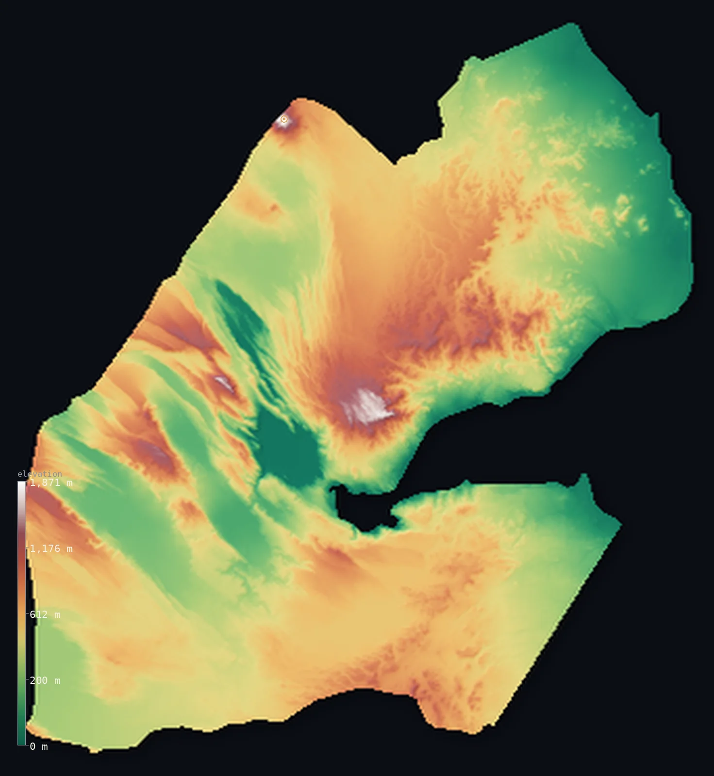
Djibouti’s highest point is Mousa Ali at 6,654 ft (2,028 m); its lowest is Lake Assal at −509 ft (−155 m); the mean elevation is 1,467 ft (447 m).
- Highest point📚
- 6,654 ft2,028 m
- Mousa Ali, a volcano on the Eritrea–Ethiopia tripoint in the north.
- Lowest point📚
- −509 ft−155 m
- Lake Assal — 155 m below sea level, the lowest point in Africa.
- Mean elevation⚙
- 1,467 ft447 m
- Computed from the GLO-30 surface model across the whole country.
- Median elevation⚙
- 1,401 ft427 m
- Half of Djibouti lies below this height.
- Elevation range📚
- 7,162 ft2,183 m
- From Lake Assal at −155 m to Mousa Ali's ~2,028 m.
- Above 1,000 m (3,281 ft)⚙
- 4%
- The volcanic mountain arc rimming the north and centre (Mousa Ali, Goda, Mabla).
- Official area📚
- 8,958 mi²23,200 km²
- A small Horn-of-Africa country at the Afar triple junction, where three tectonic rifts meet.
- Forest cover📚
- 0.2%
- Almost no forest — only a tiny vegetated remnant survives on the Goda Mountains (the Day Forest).
Highest and lowest points
The highest point of Djibouti at about 2,028 m — Mousa Ali, a stratovolcano with a summit caldera, standing at the tripoint where Djibouti, Eritrea and Ethiopia meet in the north. The 2002 boundary commission set the three-country point at the summit; its higher (south) peak is given as roughly 2,021–2,028 m, so neither neighbour's ground here is higher.
source ↗Djibouti at a glance
Djibouti holds the lowest point in Africa — Lake Assal, 155 m below sea level — which is also the third-lowest point on Earth, after the Dead Sea and the Sea of Galilee.
source ↗Lake Assal is about ten times saltier than the sea — one of the most saline bodies of water on the planet — its shores crusted in thick white salt.
source ↗Djibouti sits on the Afar triple junction, where three of the Earth's great rifts meet and the crust is actively tearing apart — the Ardoukôba volcano's 1978 eruption widened the rift by about a metre.
source ↗The country has no permanent rivers at all — only intermittent wadis that flow after rare rains, feeding closed salt lakes like Assal and Abbé.
source ↗Its highest point, Mousa Ali (~2,028 m), is a volcano that marks the exact tripoint where Djibouti, Eritrea and Ethiopia meet.
source ↗From below sea level to over 2,000 m, almost all of Djibouti is barren rock and salt — only the Goda Mountains' Day Forest keeps a small patch of trees.
source ↗
Elevation profile of Djibouti
The largest share of land, 26%, falls in the 400–600 m band, and 59% of the territory lies below 500 m (1,640 ft).
- below 500 m (1,640 ft)59%
- 500–1,000 m37%
- 1,000–2,000 m4%
Highest peaks of Djibouti
| Peak | Elevation | Range | Note |
|---|---|---|---|
| Mousa Ali↗ | 6,654 ft2,028 m | Mousa Ali range (north) | Highest point of Djibouti, a stratovolcano at the Eritrea–Ethiopia tripoint. |
| Goda Mountains (high point)↗ | 5,850 ft1,783 m | Goda Mountains (Tadjoura Region) | Northwest of the Gulf of Tadjoura — the country's largest vegetated area, holding the Day Forest. |
| Mabla Mountains (high point)↗ | 5,840 ft1,780 m | Mabla Mountains (Obock Region) | Rising behind the coastal plain where the Red Sea meets the Gulf of Aden, north of the Gulf of Tadjoura. |
| Garbi↗ | 5,512 ft1,680 m | western Tadjourah Region | A mountain of the western highland arc, part of the rocky crown above the central plateaus. |
| Arrei Mountains (high point)↗ | 4,268 ft1,301 m | Arrei Mountains (Ali Sabieh Region, south) | A southern range near the Ethiopian border, above the Grand Bara desert. |
Terrain regions of Djibouti
Djibouti holds the lowest point in Africa — Lake Assal, 155 m below sea level — which is also the third-lowest point on Earth, after the Dead Sea and the Sea of Galilee. ↗
Afar depression and Lake Assal (centre-west)
↗A below-sea-level tectonic basin at the Afar triple junction — where the Red Sea, Gulf of Aden and East African rifts meet — holding the hypersaline Lake Assal (−155 m), the lowest point in Africa, Lake Abbé on the Ethiopian border, and the young Ardoukôba volcano.
Volcanic mountain arc (north and centre)
↗A crown of volcanic massifs rimming the north and centre — Mousa Ali (the high point, ~2,028 m), the Goda Mountains (Day Forest), Mabla, Garbi and Arrei — all rising above 1,000 m.
Coastal plains and southern desert
↗Arid coastal plains around the Gulf of Tadjoura and Gulf of Aden, where the capital sits, and the flat Grand Bara desert (below ~520 m) across the south — a land of intermittent wadis, with no permanent rivers anywhere.
The Afar depression and Lake Assal
central-western depressionCentral-western Djibouti sinks into the Afar depression, part of the Danakil, at the triple junction where three of the Earth's rifts meet. Here lies Lake Assal — a hypersaline crater lake 155 m below sea level, the lowest point in Africa and the third-lowest on Earth, ringed by white salt flats and volcanic hills. The crust is actively pulling apart: the nearby Ardoukôba volcano erupted in 1978, widening the rift.
The volcanic mountain arc
northern and central highlandsAn arc of volcanic massifs rings the north and centre — the Mousa Ali range on the northern tripoint rising to ~2,028 m, the Goda Mountains (whose slopes hold the Day Forest, the country's last patch of woodland), the Mabla and Arrei ranges, and others. These rocky highlands stand above the surrounding plateaus and depressions.
Coastal plains and the Grand Bara
coast and southern plainsArid plains line the coast around the Gulf of Tadjoura — the inlet that nearly cuts the country in two — and the Gulf of Aden, where Djibouti City and the ports lie at sea level near the Bab-el-Mandeb strait. Inland to the south spreads the Grand Bara, a flat sandy desert below about 520 m. Djibouti has no permanent rivers, only seasonal wadis feeding closed salt lakes.
City elevations in Djibouti
| City | Population | Elevation |
|---|---|---|
| Djibouticapital | 626,512 | 16 ft5 m |
| Ali Sabih | 50,006 | 2,303 ft702 m |
| Dikhil | 32,801 | 1,565 ft477 m |
| Tadjoura | 19,533 | 16 ft5 m |
| Arta | 17,477 | 2,224 ft678 m |
| Obock | 15,429 | 26 ft8 m |
| ‘As ‘Êla | 5,173 | 1,138 ft347 m |
| Médého | 4,000 | 2,037 ft621 m |
| ‘Ali ‘Addé | 3,700 | 1,670 ft509 m |
| Holhol | 3,519 | 1,437 ft438 m |
Elevation sampled at each city centre from the Copernicus GLO-30 model. Cities and population from GeoNames (CC-BY 4.0).
Djibouti in comparison
Djibouti's terrain rises 7,162 ft (2,183 m) from Lake Assal, 509 ft (155 m) below sea level to Mousa Ali — about 25% of the height of Mount Everest, the world's highest point at 29,032 ft (8,849 m).
- Eritrea's mean elevation is 2,507 ft — 1,040 ft higher; its high point, Emba Soira, reaches 9,902 ft (3,018 m), 3,248 ft above. Eritrea elevation map →
- Ethiopia's mean elevation is 4,111 ft — 2,644 ft higher; its high point, Ras Dashen, reaches 14,928 ft (4,550 m), 8,274 ft above. Ethiopia elevation map →
- Somalia's mean elevation is 1,375 ft — 92 ft lower; its high point, Mount Shimbiris, reaches 8,071 ft (2,460 m), 1,417 ft above. Somalia elevation map →
Frequently asked questions
What is the highest point in Djibouti?
- Mousa Ali, about 6,654 ft (2,028 m), a volcano on the tripoint where Djibouti, Eritrea and Ethiopia meet.
What is the lowest point in Djibouti?
- Lake Assal, at 155 m below sea level — the lowest point in all of Africa and the third-lowest on Earth.
What is the average elevation of Djibouti?
- Computed from the Copernicus GLO-30 model, the area-weighted mean is 1,467 ft (447 m). The country swings from a below-sea-level depression to a 2,000 m volcanic arc over arid plateau, giving a moderate mean.
Why is Lake Assal below sea level?
- It sits in the Afar depression, a tectonic basin where three rifts pull the Earth's crust apart, dropping the land to 155 m below sea level; with no outflow and intense evaporation, it has become hypersaline.
Does Djibouti have mountains?
- Yes — a volcanic arc rings the north and centre, with eight ranges over 1,000 m, topped by Mousa Ali (~2,028 m). 79% of the land lies 200 m (656 ft) or more above sea level.
Does Djibouti have rivers?
- No permanent ones — it is the only African country without permanent rivers, relying on seasonal wadis that drain into closed salt lakes.
Where is Djibouti?
- In the Horn of Africa, on the Gulf of Aden and Red Sea by the Bab-el-Mandeb strait, bordered by Eritrea, Ethiopia and Somalia.
Is this a topographic, relief, contour, or elevation map of Djibouti?
- They describe the same thing — terrain height. This page renders Djibouti's actual elevation surface in interactive 3D (a relief or topographic view) and reports the elevation statistics computed from it; a contour map shows the same data as lines of equal height.
About this map
The terrain is rendered from the Copernicus GLO-30 digital elevation model (ESA), masked to the DJI-ADM0 boundary from geoBoundaries (gbOpen). Elevation statistics are computed directly from the model; peak names and researched facts are sourced and cited. See the methodology for the full pipeline.
Our area-weighted mean, computed from the Copernicus GLO-30 model, is 1,467 ft (447 m); the figure commonly cited elsewhere is 1,411 ft (430 m) (CIA World Factbook). Djibouti is a land of extremes — the Afar depression plunges to 155 m below sea level at Lake Assal while a volcanic mountain arc rises above 2,000 m — over mostly arid plateau and plain, giving a moderate mean; the page reports the area-weighted figure computed from the Copernicus GLO-30 model.
Surveyed national figures: official area · forest cover · high point.
Rendered from Copernicus GLO-30 (ESA, 2021 release), boundaries from geoBoundaries. Generated 2026-06-22.
Bordering countries · 3
Djibouti shares a land border with these countries — open any one to compare its terrain and highest point.