Angola Elevation Map — Topographic & 3D Terrain
Explore the terrain of Angola in interactive 3D, built from Copernicus GLO-30 satellite elevation data — a high interior plateau dropping to a narrow Atlantic coast. Drag to rotate, scroll to zoom, and tap any point to read its elevation.
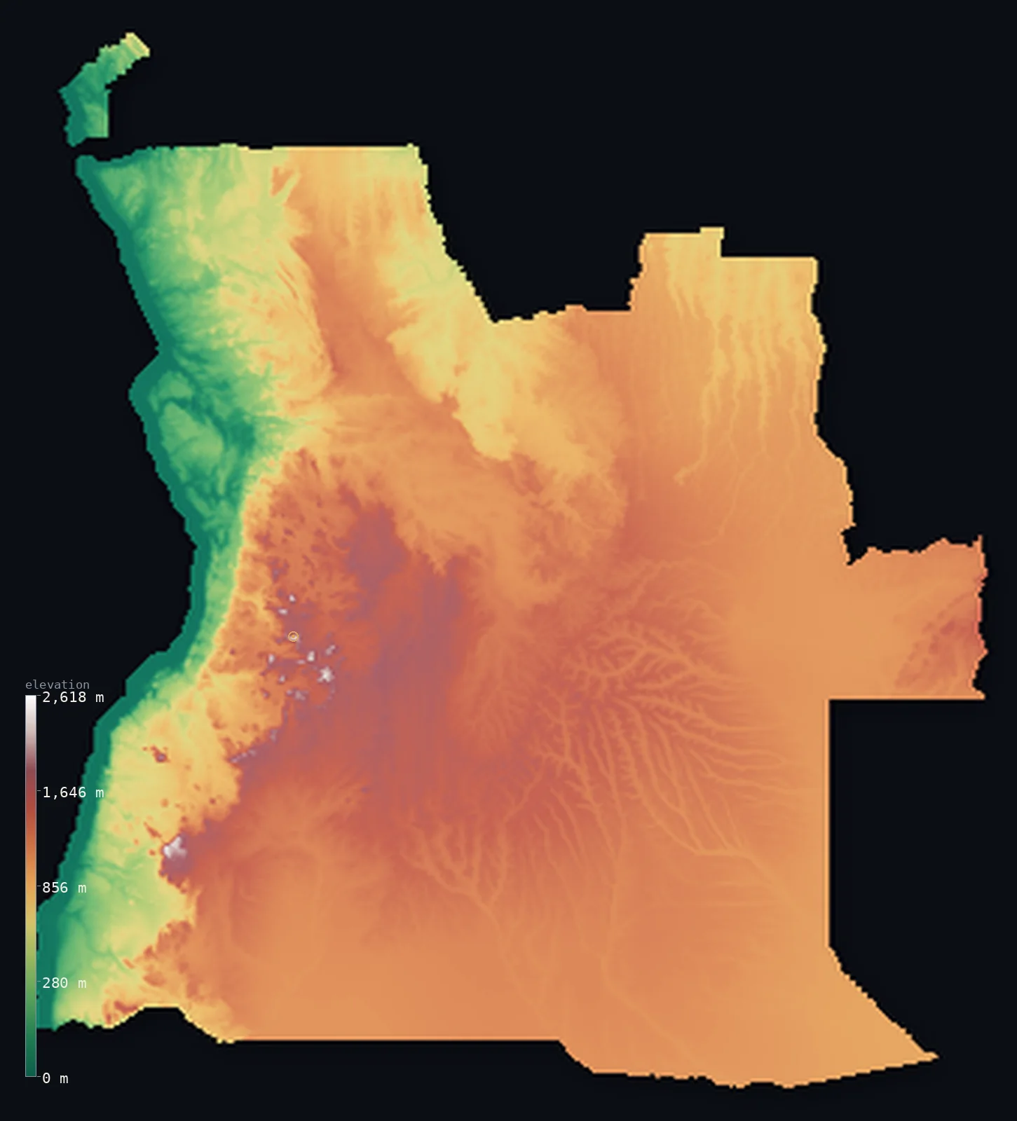
Angola’s highest point is Mount Moco (Morro de Môco) at 8,596 ft (2,620 m); its lowest is Atlantic Ocean at 0 ft (0 m); the mean elevation is 3,402 ft (1,037 m).
Angola is a high plateau above a narrow coast. Most of the country is elevated interior tableland — the vast plano central, or Bié Plateau, rolling high country lying largely above 3,300 ft, rising to Mount Moco at 8,596 ft (2,620 m) in the west-centre. Between this high interior and the Atlantic runs a narrow coastal plain, and the ground between them drops sharply down an escarpment. To the north, across the mouth of the Congo River and separated from the rest of the country by a strip of the DRC, lies the disconnected exclave of Cabinda.
- Highest point📚
- 8,596 ft2,620 m
- Angola's highest point is Mount Moco at 8,596 ft (2,620 m), in the highlands of the west-central plateau, near Huambo — the highest summit of the plano central, the great elevated tableland that covers most of the country. It rises from high plateau country rather than from lowland: even the ground around it lies well up.
- Lowest point📚
- 0 ft0 m
- Angola's lowest point is the Atlantic Ocean at sea level, along its western coast — a narrow coastal plain, dry in the south toward the Namib, that runs the length of the country between the sea and the escarpment rising to the interior plateau.
- Mean elevation⚙
- 3,402 ft1,037 m
- Computed from the GLO-30 model, Angola's mean elevation is 3,402 ft (1,037 m) — high, and a measure of a country dominated by its interior plateau: most of Angola is elevated tableland lying above 1,000 m, with only the narrow coastal plain and the river valleys lying low.
- Median elevation⚙
- 3,698 ft1,127 m
- Half of Angola lies above about 3,698 ft (1,127 m) — the plano central is so dominant that even the country's midpoint sits high on the plateau; only the narrow coast and the lower north bring any of it down.
- Elevation range📚
- 8,596 ft2,620 m
- From the Atlantic to the summit of Mount Moco at 2,620 m, Angola's terrain climbs about 8,600 ft — but the rise is concentrated: a narrow coastal plain, then a sharp escarpment, and then the high plateau that makes up most of the country, high throughout.
- Above 1,000 m (3,281 ft)⚙
- 70%
- About 70% of Angola rises above 1,000 m (3,281 ft) — the vast interior plateau, the plano central, that covers most of the country. The narrow coastal plain and the lower northern and eastern margins lie below.
- Official area📚
- 481,353 mi²1,246,700 km²
- Angola covers about 481,000 sq mi (1,246,700 sq km) — a large country in southwestern Africa on the Atlantic, dominated by a high interior plateau (the plano central) that drops down an escarpment to a narrow coastal plain, with the separate exclave of Cabinda to the north.
- Forest cover📚
- 53%
- About 53% of Angola is forested or wooded — miombo woodland and savanna across much of the plateau, denser tropical forest in the wetter north and Cabinda, and drier scrub toward the south and the coast, shading into desert in the far southwest.
Highest and lowest points
Angola's highest point is Mount Moco, 8,596 ft (2,620 m), in the central highlands near Huambo, in the west-central part of the country. It is the highest summit of the plano central — the vast elevated plateau, largely above 1,500 m, that forms the bulk of Angola — rising above high tableland rather than lowland. The highlands here, the roof of the country, are the source of many of Angola's rivers, which radiate out from this high centre: north and east toward the Congo and the Zambezi systems, west down the escarpment to the Atlantic, and south toward the Okavango. Moco is the high point of a high country.
source ↗Angola's lowest point is the Atlantic Ocean at sea level, along a western coast that runs the length of the country. The coastal plain here is narrow — widest in the north, drying southward until, in the far southwest, it meets the northern edge of the Namib Desert. Behind it the land rises sharply up an escarpment to the high interior plateau, so that the low coast is a thin margin below a high country. Far to the north, beyond the mouth of the Congo River and cut off from the rest of Angola by a strip of DRC territory, the exclave of Cabinda has its own short, wet, tropical coast.
source ↗Angola at a glance
Most of Angola is high plateau: about 65% of the country sits between 1,000 and 1,500 m, and only ~5% — the coastal strip — lies below 200 m.
source ↗Angola's central plateau is a great watershed of southern Africa — the Cuanza and Cunene rise here, and so do headwaters of both the Zambezi and the Congo.
source ↗Cabinda, the source of much of Angola's oil, is an exclave — cut off from the rest of the country by a strip of the Democratic Republic of the Congo reaching the Atlantic.
source ↗The cold Benguela Current keeps Angola's coast dry: the south merges into the dunes of the Namib Desert, and even Luanda gets only about 330 mm of rain a year.
source ↗Mount Moco's slopes hold rare patches of Afromontane forest and endemic birds like Swierstra's spurfowl — relics now threatened by firewood cutting and bushfires.
source ↗Angola's currency, the kwanza, is named after the Cuanza (Kwanza) River — the longest river lying entirely within the country, about 960 km.
source ↗Despite its tropical latitude, the highland city of Huambo averages only about 19 °C because of its altitude — far cooler than the coast at Soyo (26 °C).
source ↗
Elevation profile of Angola
The largest share of land, 35%, falls in the 1,000–1,200 m band, and 88% of the territory lies above 500 m (1,640 ft).
- below 500 m (1,640 ft)12%
- 500–1,000 m17%
- 1,000–2,000 m70%
- above 2,000 m (6,562 ft)<1%
Highest peaks of Angola
| Peak | Elevation | Range | Note |
|---|---|---|---|
| Mount Moco (Morro de Môco)↗ | 8,596 ft2,620 m | Central Highlands (Bié Plateau) | Highest point of Angola; a grassy Afromontane massif near Huambo, named a Wonder of Angola. |
| Morro de Mejo↗ | 8,474 ft2,583 m | Benguela highlands | A high peak rising from the escarpment in Benguela Province, second-highest in Angola. |
| Morro de Vavéle↗ | 8,133 ft2,479 m | Cuanza Sul highlands | A prominent peak rising from the coastal hinterland in Cuanza Sul. |
| Loviti↗ | 7,776 ft2,370 m | Benguela highlands | A high point of the Benguela escarpment in the west-central highlands. |
| Mount Elonga↗ | 7,546 ft2,300 m | Benguela highlands | Another summit of the western escarpment in Benguela Province. |
| Serra da Chela high point↗ | 7,546 ft2,300 m | Serra da Chela (Huíla) | The steep southern escarpment range above Lubango, famous for the Serra da Leba hairpin road. |
Angola: the coast, the escarpment, and the plano central
The coastal plain
Along Angola's Atlantic edge runs a narrow coastal plain — widest in the north, drying southward toward the Namib Desert. Low and mostly dry, holding the ports of Luanda, Lobito, and Benguela, it is a thin margin between the sea and the escarpment. The exclave of Cabinda, to the north, has its own wetter tropical coast.
The escarpment
Between the coast and the interior the land rises sharply up an escarpment — a steep step of hills and slopes that climbs from the low coastal plain to the high plateau in a short distance, marking the sharp divide between low coast and high interior.
The interior plateau (the plano central)
Most of Angola is the plano central — a vast high plateau of rolling tableland and savanna, largely above 1,500 m, rising to the central highlands and Mount Moco near Huambo. High, cooler, and better-watered than the coast, it is the country's great elevated core and the source of its rivers.
How to read this map
Color shows elevation; the raised relief shows real terrain. On this map Angola reads as a high plateau above a thin coast — a narrow low-green coastal strip along the Atlantic, a sharp rise up the escarpment, and then the vast mid-to-high-toned interior plateau filling the country, highest in the central highlands near Huambo. The disconnected exclave of Cabinda sits to the north, across a gap.
The 3D relief is the actual GLO-30 elevation data, exaggerated vertically so the coast, escarpment, and plateau all show; the ×N relief slider controls how much. Tap anywhere to read that point's exact elevation.
City elevations in Angola
Angola's cities split between coast and plateau — Luanda (the capital) and Benguela on the Atlantic coast; Huambo, Lubango, Cuíto, and Malanje up on the high interior plateau; and Cabinda on its own coast in the northern exclave. The low coast and the high interior each hold major cities.
| City | Population | Elevation |
|---|---|---|
| Luandacapitalthe capital and main port, on the Atlantic coast ↗ | 2,776,168 | 246 ft75 m |
| Lubangoon the southern plateau, high in the highlands ↗ | 600,751 | 5,768 ft1,758 m |
| Huamboon the central plateau in the highlands, near Mount Moco ↗ | 595,304 | 5,620 ft1,713 m |
| Benguelaa port on the Atlantic coast in the west ↗ | 555,124 | 23 ft7 m |
| Cabindathe capital of the Cabinda exclave, on its own coast north of the Congo mouth ↗ | 550,000 | 108 ft33 m |
| Malanjeon the northern plateau ↗ | 455,000 | 3,711 ft1,131 m |
| Saurimoin the northeastern interior (the Lundas) ↗ | 393,000 | 3,504 ft1,068 m |
| Cuítoon the high central Bié Plateau ↗ | 355,423 | 5,564 ft1,696 m |
| Uígein the north, on lower ground toward the Congo basin ↗ | 322,531 | 2,684 ft818 m |
| Luenain the east, on the interior plateau ↗ | 273,675 | 4,377 ft1,334 m |
Elevation sampled at each city centre from the Copernicus GLO-30 model. Cities and population from GeoNames (CC-BY 4.0).
Angola in comparison
Angola's terrain rises 8,596 ft (2,620 m) from sea level to Mount Moco (Morro de Môco) — about 30% of the height of Mount Everest, the world's highest point at 29,032 ft (8,849 m).
- Zambia's mean elevation is 3,671 ft — 269 ft higher; its high point, Mafinga Central, reaches 7,674 ft (2,339 m), 922 ft below. Zambia elevation map →
- Namibia's mean elevation is 3,573 ft — 171 ft higher; its high point, Konigstein (Brandberg), reaches 8,442 ft (2,573 m), 154 ft below. Namibia elevation map →
- Democratic Republic of the Congo's mean elevation is 2,244 ft — 1,158 ft lower; its high point, Margherita Peak (Mount Stanley), reaches 16,762 ft (5,109 m), 8,166 ft above. Democratic Republic of the Congo elevation map →
Frequently asked questions
What is the highest point in Angola?
- Mount Moco, 8,596 ft (2,620 m), in the central highlands near Huambo — the highest summit of the plano central, the high interior plateau that covers most of the country.
What is the lowest point in Angola?
- The Atlantic Ocean at sea level, along the narrow western coastal plain that runs below the escarpment.
What is the average elevation of Angola?
- Computed from the Copernicus GLO-30 model, the area-weighted mean is 3,402 ft (1,037 m) — high, because most of Angola is the elevated interior plateau, with only the narrow coast and river valleys low.
What is the plano central?
- Angola's vast interior plateau — rolling high tableland largely above 1,500 m, covering most of the country, rising to Mount Moco, and dropping sharply down an escarpment to the narrow Atlantic coast.
What is Cabinda?
- A small, oil-rich exclave of Angola on the Atlantic coast, separated from the rest of the country by a strip of DRC territory north of the mouth of the Congo River — wetter and more tropical than the main country.
Is this a topographic, relief, contour, or elevation map of Angola?
- They describe the same thing — terrain height. This page renders the country's actual elevation surface in interactive 3D and reports the statistics computed from it.
About this map
The terrain is rendered from the Copernicus GLO-30 digital elevation model (ESA), masked to the AGO-ADM0 boundary from geoBoundaries (gbOpen). Elevation statistics are computed directly from the model; peak names and researched facts are sourced and cited. See the methodology for the full pipeline.
Our area-weighted mean, computed from the Copernicus GLO-30 model, is 3,402 ft (1,037 m); the figure commonly cited elsewhere is 3,648 ft (1,112 m) (CIA World Factbook). Most of Angola is the high plano central, elevated tableland lying largely above 1,000 m, with only the narrow coast and the river valleys low — so its area-weighted mean is high. The figure computed here from the Copernicus GLO-30 model is about 1,037 m; the CIA World Factbook cites 1,112 m.
Surveyed national figures: official area · forest cover · high point.
Rendered from Copernicus GLO-30 (ESA, 2021 release), boundaries from geoBoundaries. Generated 2026-07-09.
Bordering countries · 4
Angola shares a land border with these countries — open any one to compare its terrain and highest point.