Namibia Elevation Map — Topographic & 3D Terrain
Explore the terrain of Namibia in interactive 3D, built from Copernicus GLO-30 satellite elevation data — a desert coast rising through an escarpment to a high interior plateau and the Kalahari. Drag to rotate, scroll to zoom, and tap any point to read its elevation.
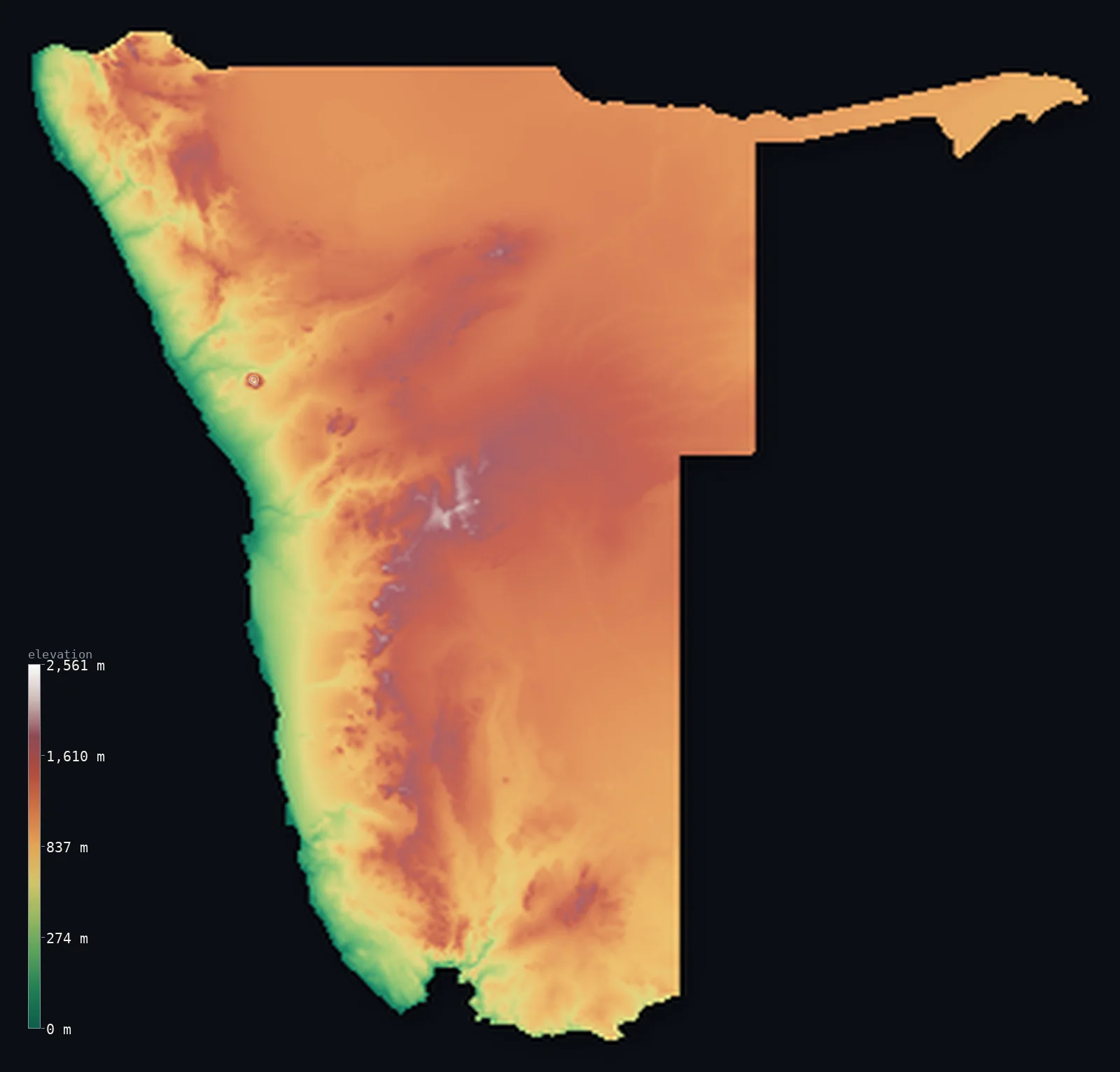
Namibia’s highest point is Konigstein (Brandberg) at 8,442 ft (2,573 m); its lowest is Atlantic Ocean at 0 ft (0 m); the mean elevation is 3,573 ft (1,089 m).
Namibia is a dry country of desert, escarpment, and high plateau. Along the Atlantic runs the Namib — one of the oldest and driest deserts on Earth, a strip of towering dunes and gravel plains the length of the coast. Behind it the land climbs a great escarpment to a high central plateau, rolling and semi-arid, rising to the Brandberg massif whose summit Königstein reaches 8,442 ft (2,573 m). Eastward the plateau falls away into the sands of the Kalahari. Namibia is one of the driest and most sparsely populated countries in the world.
- Highest point📚
- 8,442 ft2,573 m
- Namibia's highest point is Königstein, on the Brandberg massif, at 8,442 ft (2,573 m) — a great granite dome rising abruptly from the plains of the northwest, the highest point in the country. The Brandberg — the 'Fire Mountain,' glowing at sunset — stands isolated above the surrounding desert and semi-arid plateau, the roof of a dry, high land.
- Lowest point📚
- 0 ft0 m
- Namibia's lowest point is the Atlantic Ocean at sea level, along the desert coast — the cold, fog-bound Namib shore of dunes and gravel plains, one of the most barren and dramatic coastlines on Earth.
- Mean elevation⚙
- 3,573 ft1,089 m
- Computed from the GLO-30 model, Namibia's mean elevation is 3,573 ft (1,089 m) — a striking figure for so dry a country: two deserts bracket it, the Namib on the coast and the Kalahari in the east, yet the high central plateau between them is broad and elevated enough to carry the average well up.
- Median elevation⚙
- 3,747 ft1,142 m
- Half of Namibia lies above about 3,747 ft (1,142 m) — a high midpoint for so dry a country, and a reminder that the central plateau, not the famous Namib coast, is where most of Namibia actually lies.
- Elevation range📚
- 8,442 ft2,573 m
- Namibia's whole relief spans about 8,440 ft, desert coast to the granite crown of the Brandberg at 2,573 m — but the climb is front-loaded in the west: the Namib and the escarpment do most of the rising, and beyond them the high plateau runs on, broad and even, toward the Kalahari.
- Above 1,000 m (3,281 ft)⚙
- 71%
- About 71% of Namibia stands above 1,000 m (3,281 ft) — nearly three-quarters of it, up on the central plateau; only the coastal Namib in the west and the Kalahari's lower margins in the east drop beneath that line.
- Official area📚
- 318,261 mi²824,292 km²
- Namibia covers about 318,000 sq mi (824,292 sq km) — a large, dry country in southwestern Africa on the Atlantic, with the Namib Desert along the coast, a great escarpment rising to a high central plateau, and the Kalahari in the east, one of the most sparsely populated countries on Earth.
- Forest cover📚
- 8%
- About 8% of Namibia is forested — very little, as most of the country is desert, semi-desert, and dry savanna; what woodland there is lies in the wetter north and northeast, toward the Kavango and the Caprivi Strip, with the rest of the country too dry for forest.
Highest and lowest points
Namibia's highest point is Königstein, the summit of the Brandberg massif, at 8,442 ft (2,573 m), rising from the plains of the northwest. The Brandberg — the 'Fire Mountain,' named for the way it glows red-orange at sunset — is a huge granite dome standing in isolation above the surrounding desert and semi-arid plateau, a landmark visible for great distances and famous for its ancient rock art, including the 'White Lady.' It is the high point of Namibia's central plateau region, the elevated tableland that covers much of the country between the coastal Namib and the eastern Kalahari — a dry, high land of which the Brandberg is the solitary roof.
source ↗Namibia's lowest point is the Atlantic Ocean at sea level, along one of the most striking coastlines on Earth — the Namib Desert shore, where towering dunes and barren gravel plains meet a cold, fog-bound sea. The cold Benguela Current chills the coast and starves it of rain, so that desert runs right to the water's edge; the fog it brings is the main moisture for the desert's specialized life. This is the 'Skeleton Coast' of the north, littered with shipwrecks. Behind it the land rises through the escarpment to the interior — the low coast a narrow, extreme desert margin below a high, dry country.
source ↗Namibia at a glance
Namibia's high point, the Konigstein, crowns the Brandberg - an isolated granite dome so circular and distinct it is one of the most eye-catching features visible from space.
source ↗The Brandberg rises about 2,000 m straight out of the flat Namib plains, yet is entirely uninhabited and climbed by only a few dozen parties a year.
source ↗The Namib, along Namibia's coast, is considered the oldest desert on Earth.
source ↗The Brandberg holds the famous 'White Lady' rock painting among more than 45,000 prehistoric images at over 1,000 sites.
source ↗Namibia has almost no perennial inland rivers - permanent water flows only along its northern and southern borders.
source ↗It is one of the least densely populated countries on Earth, most of it desert or semi-desert.
source ↗
Elevation profile of Namibia
The largest share of land, 33%, falls in the 1,000–1,200 m band, and 92% of the territory lies above 500 m (1,640 ft).
- below 500 m (1,640 ft)8%
- 500–1,000 m21%
- 1,000–2,000 m71%
- above 2,000 m (6,562 ft)<1%
Highest peaks of Namibia
| Peak | Elevation | Range | Note |
|---|---|---|---|
| Konigstein (Brandberg)↗ | 8,442 ft2,573 m | Brandberg massif (Erongo, northwest) | Highest point of Namibia, the summit of an isolated granite massif in the Namib. |
| Moltkeblick↗ | 8,133 ft2,479 m | Auas Mountains (central, near Windhoek) | The highest of the Auas Mountains, on the central plateau southeast of Windhoek. |
| Gamsberg↗ | 7,700 ft2,347 m | Khomas Hochland (central) | A flat-topped, quartzite-capped mountain on the central plateau, a noted astronomy site. |
| Naukluft (high ground)↗ | 6,440 ft1,963 m | Naukluft Mountains (central-west) | A rugged karst massif at the edge of the escarpment, part of the Namib-Naukluft Park. |
| Spitzkoppe↗ | 5,669 ft1,728 m | Erongo (northwest) | An iconic granite inselberg sometimes called the 'Matterhorn of Namibia'. |
Namibia: the Namib, the plateau, and the Kalahari
The Namib and the coast
Along Namibia's Atlantic edge runs the Namib Desert — one of the oldest and driest on Earth, a strip of towering dunes (as at Sossusvlei) and barren gravel plains meeting a cold, fog-bound sea. Extreme, dramatic, and nearly rainless, including the shipwreck-strewn Skeleton Coast, it is the country's desert seaboard.
The escarpment and central plateau
Behind the coast the land climbs a great escarpment to a high central plateau — rolling, semi-arid tableland covering much of the country, rising to isolated massifs like the Brandberg (the high point) and holding the capital, Windhoek. High, dry, and open, it is the country's populous core.
The Kalahari and the east
Eastward the plateau fades into the Kalahari — a vast semi-arid basin of red sand, dunes, and dry savanna reaching into Botswana. In the far northeast the wetter Caprivi Strip, a narrow panhandle, reaches toward the Zambezi. Dry sandveld across most of the east.
How to read this map
Color shows elevation; the raised relief shows real terrain. On this map Namibia reads as a high dry plateau between two deserts — the low coastal Namib in the west, a sharp rise up the escarpment, the high mid-toned central plateau filling the interior (with the Brandberg standing out in the northwest), and the eastern ground fading toward the Kalahari, with the Caprivi panhandle reaching east in the far northeast.
The 3D relief is the actual GLO-30 elevation data, exaggerated vertically so the low Namib, the escarpment, and the high interior all read; the ×N relief slider controls how much. Tap anywhere to read that point's exact elevation.
City elevations in Namibia
Namibia's cities sit mostly on the central plateau — Windhoek (the capital), Otjiwarongo, Grootfontein, Gobabis, and Keetmanshoop in the interior highlands — with Walvis Bay and Lüderitz on the Atlantic (Namib) coast, Oshakati and Rundu in the wetter north, and Katima Mulilo out in the Caprivi Strip. Most lie high on the plateau or on the desert coast.
| City | Population | Elevation |
|---|---|---|
| Windhoekcapitalthe capital, on the central plateau in the highlands ↗ | 386,219 | 5,436 ft1,657 m |
| Runduin the north on the Kavango River, at the Angolan border ↗ | 75,180 | 3,642 ft1,110 m |
| Walvis Baythe main port, on the Atlantic (Namib) coast ↗ | 73,598 | 10 ft3 m |
| Oshakatiin the wetter far north, on the Owambo plain ↗ | 43,309 | 3,599 ft1,097 m |
| Katima Muliloin the far northeast, in the Caprivi Strip on the Zambezi ↗ | 33,615 | 3,100 ft945 m |
| Otjiwarongoon the north-central plateau ↗ | 33,481 | 4,816 ft1,468 m |
| Grootfonteinin the northeast interior ↗ | 24,099 | 4,744 ft1,446 m |
| Keetmanshoopin the dry south, on the plateau ↗ | 23,049 | 3,268 ft996 m |
| Gobabisin the east, toward the Kalahari ↗ | 22,639 | 4,728 ft1,441 m |
| Lüderitza port on the southern Namib coast ↗ | 15,137 | 43 ft13 m |
Elevation sampled at each city centre from the Copernicus GLO-30 model. Cities and population from GeoNames (CC-BY 4.0).
Namibia in comparison
Namibia's terrain rises 8,442 ft (2,573 m) from sea level to Konigstein (Brandberg) — about 29% of the height of Mount Everest, the world's highest point at 29,032 ft (8,849 m).
- South Africa's mean elevation is 3,383 ft — 190 ft lower; its high point, Mafadi, reaches 11,319 ft (3,450 m), 2,877 ft above. South Africa elevation map →
- Botswana's mean elevation is 3,383 ft — 190 ft lower; its high point, Monalanong Hill, reaches 4,905 ft (1,495 m), 3,537 ft below. Botswana elevation map →
- Angola's mean elevation is 3,402 ft — 171 ft lower; its high point, Mount Moco (Morro de Môco), reaches 8,596 ft (2,620 m), 154 ft above. Angola elevation map →
Frequently asked questions
What is the highest point in Namibia?
- Königstein, on the Brandberg massif, 8,442 ft (2,573 m) — a huge isolated granite dome rising from the northwestern plains, the country's high point.
What is the lowest point in Namibia?
- The Atlantic Ocean at sea level, along the Namib Desert coast — a cold, fog-bound shore of dunes and gravel plains.
What is the average elevation of Namibia?
- Computed from the Copernicus GLO-30 model, the area-weighted mean is 3,573 ft (1,089 m) — high, because a great central plateau covers much of the country, with only the desert coast and eastern Kalahari margins lower.
What is the Namib Desert?
- One of the oldest and driest deserts on Earth, running the length of Namibia's Atlantic coast — towering dunes and gravel plains meeting a cold, fog-bound sea, including the Skeleton Coast.
Is Namibia flat?
- No — it rises from the desert coast up a great escarpment to a high central plateau, with isolated massifs like the Brandberg (2,573 m) and the eastern Kalahari sands. Most of the country is high, dry tableland.
Is this a topographic, relief, contour, or elevation map of Namibia?
- They describe the same thing — terrain height. This page renders the country's actual elevation surface in interactive 3D and reports the statistics computed from it.
About this map
The terrain is rendered from the Copernicus GLO-30 digital elevation model (ESA), masked to the NAM-ADM0 boundary from geoBoundaries (gbOpen). Elevation statistics are computed directly from the model; peak names and researched facts are sourced and cited. See the methodology for the full pipeline.
Our area-weighted mean, computed from the Copernicus GLO-30 model, is 3,573 ft (1,089 m); the figure commonly cited elsewhere is 3,743 ft (1,141 m) (CIA World Factbook). A great central plateau covers much of Namibia, lifting most of the country well above the sea, with only the desert Namib coast and the eastern Kalahari margins low — so its area-weighted mean is high. The figure computed here from the Copernicus GLO-30 model is about 1,089 m; the CIA World Factbook cites 1,141 m.
Surveyed national figures: official area · forest cover · high point.
Rendered from Copernicus GLO-30 (ESA, 2021 release), boundaries from geoBoundaries. Generated 2026-06-25.
Bordering countries · 4
Namibia shares a land border with these countries — open any one to compare its terrain and highest point.