Lebanon Elevation Map — Topographic & 3D Terrain
Explore the terrain of Lebanon in interactive 3D, built from Copernicus GLO-30 satellite elevation data — a small, mountainous country of two ranges and the valley between, on the eastern Mediterranean. Drag to rotate, scroll to zoom, and tap any point to read its elevation.
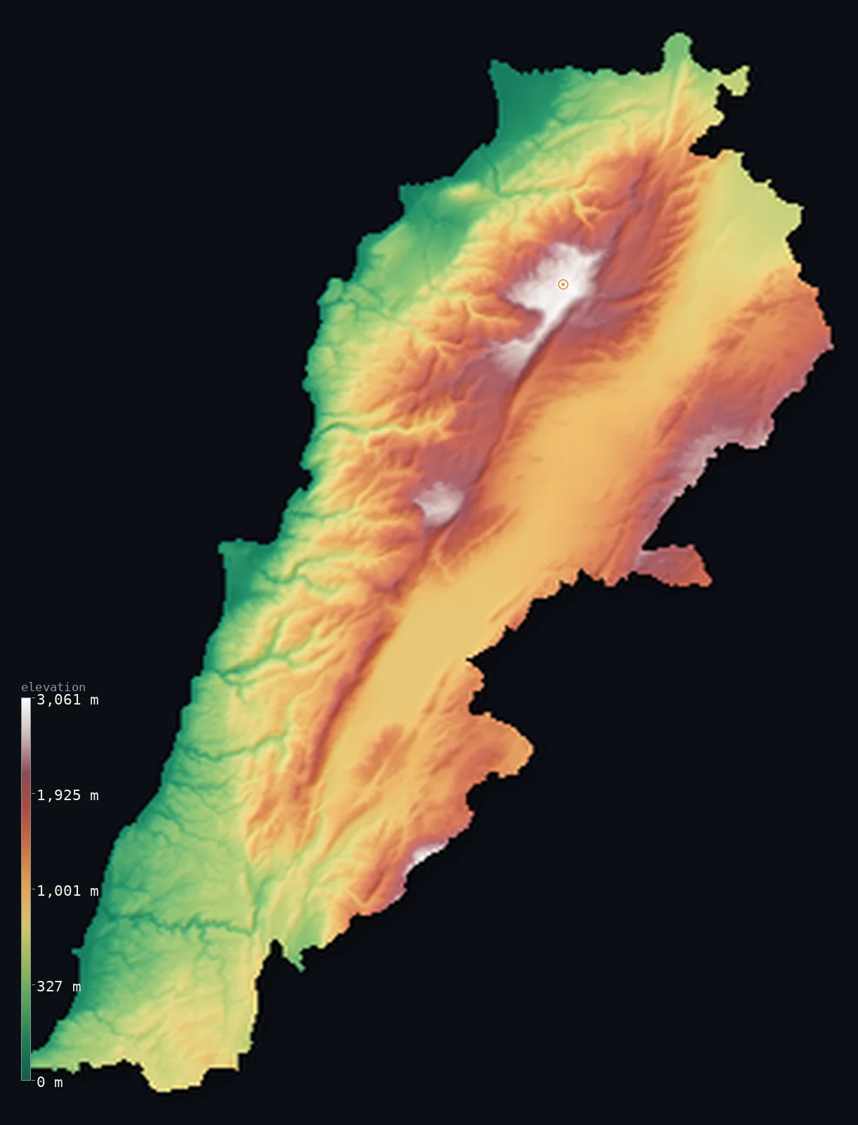
Lebanon’s highest point is Qurnat as Sawda at 10,131 ft (3,088 m); its lowest is Mediterranean Sea at 0 ft (0 m); the mean elevation is 3,271 ft (997 m).
Lebanon is a small, mountainous country on the eastern shore of the Mediterranean — a land defined by two parallel mountain ranges and the great valley between them. From a narrow coastal strip, the land rises steeply to the Mount Lebanon range, running the length of the country and holding its highest peak, Qurnat as Sawda, at 10,131 ft (3,088 m), snow-capped in winter. Behind it lies the fertile Beqaa Valley, high and broad; and beyond that rises the Anti-Lebanon range along the Syrian border, culminating in the south at Mount Hermon. So Lebanon is a country of mountains and a high valley, its terrain steep and vertical — more than half of it lies above about 3,130 ft (954 m). Snow on the heights gives the country its name.
- Highest point📚
- 10,131 ft3,088 m
- Lebanon's highest point is Qurnat as Sawda at 10,131 ft (3,088 m), in the Mount Lebanon range in the north of the country — the high crown of the range that runs the length of Lebanon, close above the Mediterranean coast. It is snow-capped for much of the year — indeed the name Lebanon is often traced to a word for 'white,' for the snow on these heights — a high, bare summit above the cedar groves and mountain villages of the range.
- Lowest point📚
- 0 ft0 m
- Lebanon's lowest point is the Mediterranean Sea at sea level, along its western coast — a narrow coastal plain, in places barely a strip between the sea and the mountains, holding Beirut and most of the country's cities. From this coast the land rises steeply and quickly into the Mount Lebanon range.
- Mean elevation⚙
- 3,271 ft997 m
- Computed from the GLO-30 model, Lebanon's mean elevation is 3,271 ft (997 m) — a high figure, for Lebanon is a genuinely mountainous country: two parallel ranges (Mount Lebanon and the Anti-Lebanon) with the high Beqaa Valley between them, and only a narrow coastal strip lying low. More than half the country lies above about 3,130 ft (954 m).
- Median elevation⚙
- 3,130 ft954 m
- More than half of Lebanon lies above about 3,130 ft (954 m) — a high figure reflecting a mountainous country: from the narrow coast, the land rises steeply into the Mount Lebanon range, and beyond the high Beqaa Valley rises the Anti-Lebanon along the Syrian border. Only the coastal strip lies low; most of Lebanon is mountain and high valley.
- Elevation range📚
- 10,131 ft3,088 m
- From the Mediterranean coast to the summit of Qurnat as Sawda at 3,088 m, Lebanon's terrain climbs about 10,131 ft — a great rise for so small a country, from a warm Mediterranean shore up to a snow-capped peak, all within a short distance inland.
- Above 1,000 m (3,281 ft)⚙
- 47%
- About 47% of Lebanon rises above 1,000 m (3,281 ft) — much of the country, for Lebanon is mountainous: the Mount Lebanon range, the high Beqaa Valley, and the Anti-Lebanon all sit high. Only the narrow coastal strip lies below.
- Above 2,000 m (6,562 ft)⚙
- 7%
- Roughly 7% of Lebanon stands above 2,000 m (6,562 ft) — the high country of the two ranges, the crests of Mount Lebanon (rising to Qurnat as Sawda) and the Anti-Lebanon (to Mount Hermon in the south).
- Official area📚
- 4,036 mi²10,452 km²
- Lebanon covers about 4,036 sq mi (10,452 sq km) — a small, mountainous country on the eastern Mediterranean, of two parallel ranges (Mount Lebanon along the coast, holding Qurnat as Sawda, and the Anti-Lebanon along the Syrian border) with the fertile Beqaa Valley high between them, and a narrow coastal strip.
- Forest cover📚
- 13.4%
- About 13.4% of Lebanon is forested — including the famous cedars of Lebanon, the ancient groves high on the Mount Lebanon range, with pine and oak on the mountain slopes, though much of the historic forest is long cleared; the Beqaa Valley is fertile farmland and the coast is built up.
Highest and lowest points
Lebanon's highest point is Qurnat as Sawda, 10,131 ft (3,088 m), in the Mount Lebanon range in the north of the country — the high crown of the range that runs the length of Lebanon, close above the Mediterranean. Its bare summit is snow-capped for much of the year; indeed the name 'Lebanon' is often traced to a Semitic root for 'white,' after the snow on these heights. Below the summit lie the famous cedar groves — the cedars of Lebanon, the national emblem, ancient trees high on the range — and mountain villages. Mount Lebanon is one of two parallel ranges that define the country: it runs along the coast, while the Anti-Lebanon range runs along the Syrian border to the east, the two separated by the high Beqaa Valley. Qurnat as Sawda is the highest point of Mount Lebanon and of the whole country — a snow-capped Mediterranean summit rising, remarkably, close above a warm coast.
source ↗Lebanon's lowest point is the Mediterranean Sea at sea level, along its western coast — a narrow coastal plain, in places barely a strip of land between the sea and the mountains, yet holding Beirut, Tripoli, Sidon, Tyre, and most of Lebanon's people. From this coast the land rises with striking steepness. First comes the Mount Lebanon range — a high wall running the entire length of the country, close above the sea, holding Qurnat as Sawda (3,088 m, the highest point), the ancient cedar groves, and mountain villages, snow-capped in winter. Behind Mount Lebanon opens the Beqaa Valley — a high, broad, fertile plain, the country's agricultural heart, a northern continuation of the great Rift Valley system. Beyond the Beqaa rises the second range, the Anti-Lebanon, running along the border with Syria, and culminating in the south in Mount Hermon, whose high slopes are shared between Lebanon, Syria, and the Israeli-occupied Golan. So Lebanon is, almost in its entirety, mountains and a high valley — a small land of great verticality, rising from a thin coast to snow-capped peaks.
source ↗Lebanon at a glance
Lebanon is defined by two parallel mountain ranges — Mount Lebanon along the coast and the Anti-Lebanon along the Syrian border — with the fertile Beqaa Valley high between them.
source ↗Lebanon's highest point, Qurnat as Sawda (3,088 m), in the Mount Lebanon range, is snow-capped much of the year — the name 'Lebanon' is often traced to a word for the whiteness of that snow.
source ↗The cedars of Lebanon — ancient trees high on the Mount Lebanon range — are the national emblem, appearing on the country's flag.
source ↗So mountainous is Lebanon that more than half the country lies above about 950 m — only a narrow coastal strip, holding Beirut and most cities, lies low.
source ↗The Beqaa Valley, high between Lebanon's two ranges, is the country's fertile agricultural heart — and a northern continuation of the great Rift Valley system.
source ↗Mount Hermon, at the southern end of the Anti-Lebanon range, has high slopes shared between Lebanon, Syria, and the Israeli-occupied Golan.
source ↗
Elevation profile of Lebanon
The largest share of land, 13%, falls in the 800–1,000 m band, and 75% of the territory lies above 500 m (1,640 ft).
- below 500 m (1,640 ft)25%
- 500–1,000 m29%
- 1,000–2,000 m40%
- above 2,000 m (6,562 ft)7%
Highest peaks of Lebanon
| Peak | Elevation | Range | Note |
|---|---|---|---|
| Qurnat as Sawda↗ | 10,131 ft3,088 m | Mount Lebanon (Jabal al Makmel, north) | Highest point of Lebanon and the Levant, in the north of the Mount Lebanon range above the Cedars of God. |
| Mount Hermon↗ | 9,232 ft2,814 m | Anti-Lebanon (Syria border, southeast) | The southern Anti-Lebanon massif on the Syrian border; its summit straddles the frontier, with Lebanon holding its western slopes. |
| Mount Sannine↗ | 8,622 ft2,628 m | Mount Lebanon (central) | A prominent snow-capped massif of the central Mount Lebanon range, overlooking Beirut. |
Lebanon: Mount Lebanon and the coast, the Beqaa Valley, and the Anti-Lebanon
Mount Lebanon and the coast
From a narrow Mediterranean coastal strip — holding Beirut and most cities — the land rises steeply into the Mount Lebanon range, a high wall running the length of the country, holding Qurnat as Sawda (the high point) and the ancient cedars. The country's coastal range and its people's edge.
The Beqaa Valley
Behind Mount Lebanon lies the Beqaa Valley — a high, broad, fertile plain, the agricultural heart of Lebanon, a northern continuation of the Rift Valley system. The high valley between the ranges.
The Anti-Lebanon and Hermon — the east
Beyond the Beqaa rises the Anti-Lebanon range along the Syrian border, culminating in the south at Mount Hermon (its slopes shared with Syria and the occupied Golan). Lebanon's eastern mountain wall.
How to read this map
Color shows elevation; the raised relief shows real terrain. On this map Lebanon reads as two mountain walls with a valley between — the browns and whites of the Mount Lebanon range rising steeply just inland of the narrow coastal strip (highest at Qurnat as Sawda in the north), the high Beqaa Valley behind it, and the Anti-Lebanon range along the eastern (Syrian) border, ending in Mount Hermon to the south. The narrow green coast holds Beirut and the cities.
The 3D relief is the actual GLO-30 elevation data, exaggerated vertically so the two ranges and the valley between show; the ×N relief slider controls how much. Tap anywhere to read that point's exact elevation.
City elevations in Lebanon
Lebanon's cities crowd the narrow coastal strip — Beirut, the capital, on the Mediterranean, with Tripoli to the north, Sidon and Tyre to the south, and Zahlé inland in the Beqaa Valley. Most of the population lives low, on the coast, below the steep mountains.
| City | Population | Elevation |
|---|---|---|
| Beirutcapitalthe capital, on the Mediterranean coast ↗ | 1,916,100 | 148 ft45 m |
| Tripolion the north coast ↗ | 229,398 | 105 ft32 m |
| Sidonon the coast south of Beirut ↗ | 163,554 | 36 ft11 m |
| Tyreon the coast in the far south ↗ | 135,204 | 33 ft10 m |
| Nabatîyé et Tahta | 120,000 | 1,388 ft423 m |
| Zahléinland, in the Beqaa Valley ↗ | 78,145 | 3,189 ft972 m |
| Aarsâl | 50,000 | 4,623 ft1,409 m |
| Baalbekin the northern Beqaa Valley ↗ | 30,916 | 3,885 ft1,184 m |
| Chmistâr | 30,000 | 3,737 ft1,139 m |
| En Nâqoûra | 24,910 | 217 ft66 m |
Elevation sampled at each city centre from the Copernicus GLO-30 model. Cities and population from GeoNames (CC-BY 4.0).
Lebanon in comparison
Lebanon's terrain rises 10,131 ft (3,088 m) from sea level to Qurnat as Sawda — about 35% of the height of Mount Everest, the world's highest point at 29,032 ft (8,849 m).
- Syria's mean elevation is 1,696 ft — 1,575 ft lower; its high point, Mount Hermon (Jabal al-Shaykh), reaches 9,232 ft (2,814 m), 899 ft below. Syria elevation map →
- Israel's mean elevation is 928 ft — 2,343 ft lower; its high point, Mount Meron, reaches 3,963 ft (1,208 m), 6,168 ft below. Israel elevation map →
- Jordan's mean elevation is 2,520 ft — 751 ft lower; its high point, Jabal Umm ad Dami, reaches 6,083 ft (1,854 m), 4,049 ft below. Jordan elevation map →
Frequently asked questions
What is the highest point in Lebanon?
- Qurnat as Sawda, 10,131 ft (3,088 m), in the Mount Lebanon range in the north — snow-capped much of the year, the high crown of the range that runs the length of the country.
What is the lowest point in Lebanon?
- The Mediterranean Sea at sea level, along the narrow western coast where Beirut and most cities lie.
What is the average elevation of Lebanon?
- Computed from the Copernicus GLO-30 model, the area-weighted mean is 3,271 ft (997 m) — high, because Lebanon is genuinely mountainous: two ranges with the high Beqaa Valley between them, and only a narrow coastal strip lying low. More than half the country lies above about 3,130 ft (954 m).
Why is Lebanon called Lebanon?
- The name is often traced to a Semitic root meaning 'white' — after the snow that caps the country's mountains, including its highest point, Qurnat as Sawda, for much of the year.
What are the two mountain ranges of Lebanon?
- Mount Lebanon, running along the coast (holding Qurnat as Sawda, the high point), and the Anti-Lebanon, running along the Syrian border (ending in Mount Hermon) — with the fertile Beqaa Valley high between them.
Is this a topographic, relief, contour, or elevation map of Lebanon?
- They describe the same thing — terrain height. This page renders the country's actual elevation surface in interactive 3D and reports the statistics computed from it.
About this map
The terrain is rendered from the Copernicus GLO-30 digital elevation model (ESA), masked to the LBN-ADM0 boundary from geoBoundaries (gbOpen). Elevation statistics are computed directly from the model; peak names and researched facts are sourced and cited. See the methodology for the full pipeline.
Our area-weighted mean, computed from the Copernicus GLO-30 model, is 3,271 ft (997 m); the figure commonly cited elsewhere is 4,101 ft (1,250 m) (CIA World Factbook). Lebanon is a small country stood on its edge — almost all mountain and high valley. From a narrow Mediterranean coast, the land rises steeply into the Mount Lebanon range, which runs the whole length of the country and holds the high point, Qurnat as Sawda; behind it the fertile Beqaa Valley sits high and broad; and beyond that the Anti-Lebanon range rises along the Syrian border, ending in the south at Mount Hermon. So little of Lebanon is low that more than half of it lies above about 3,130 ft (954 m) — only the thin coastal strip, where Beirut and most cities crowd between the sea and the heights, lies near sea level. Snow caps the ranges in winter; the name Lebanon itself is often traced to a word for the whiteness of that snow. (The mean here is computed directly from the GLO-30 surface, and runs below a higher average sometimes cited elsewhere.)
Surveyed national figures: official area · forest cover · high point.
Rendered from Copernicus GLO-30 (ESA, 2021 release), boundaries from geoBoundaries. Generated 2026-06-23.
Bordering countries · 2
Lebanon shares a land border with these countries — open any one to compare its terrain and highest point.