Syria Elevation Map — Topographic & 3D Terrain
Explore the terrain of Syria in interactive 3D, built from Copernicus GLO-30 satellite elevation data — a narrow coastal plain and mountains giving way to a vast interior of plateau and desert. Drag to rotate, scroll to zoom, and tap any point to read its elevation.
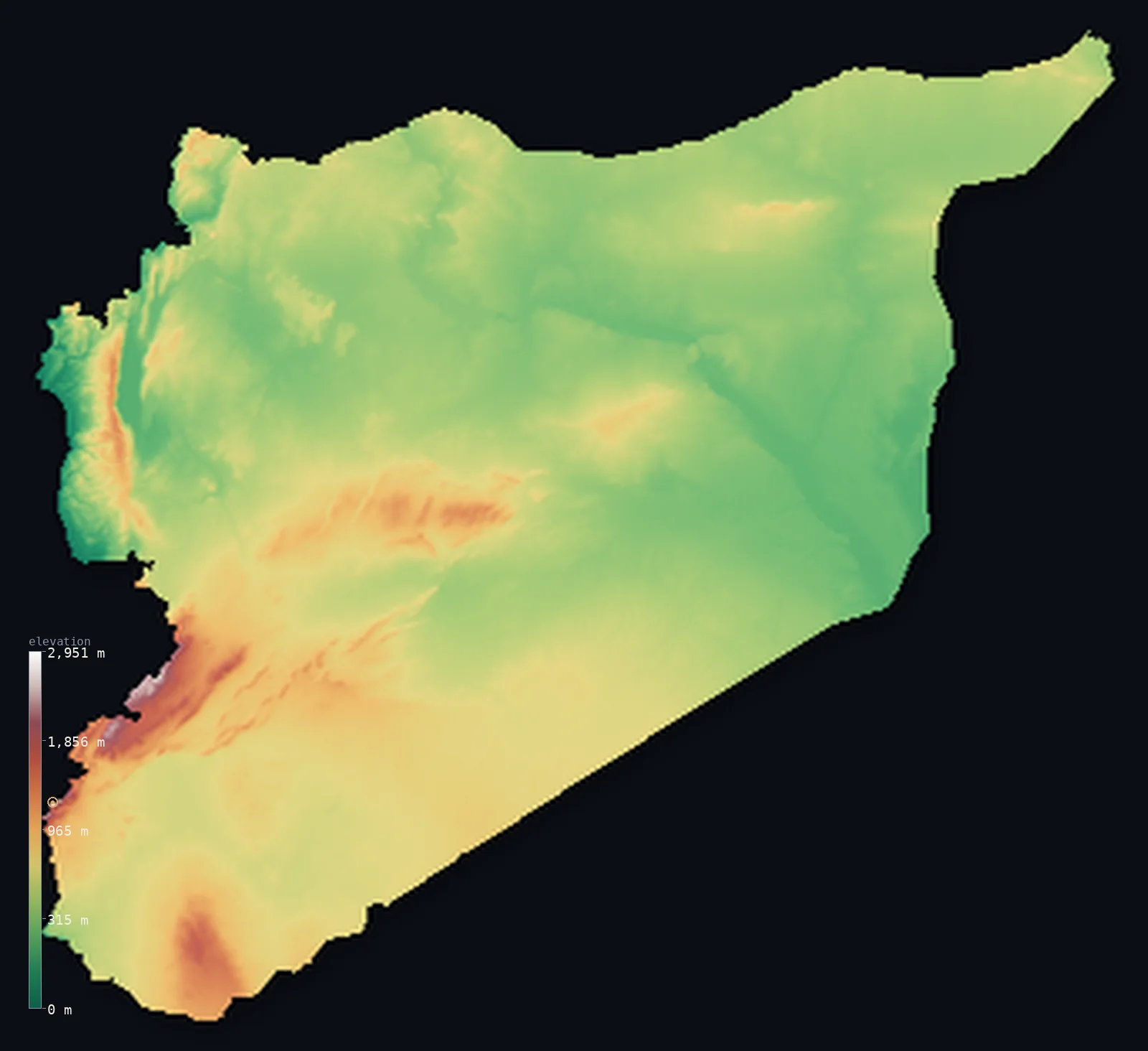
Syria’s highest point is Mount Hermon (Jabal al-Shaykh) at 9,232 ft (2,814 m); its lowest is Unnamed location near Lake Tiberias at −656 ft (−200 m); the mean elevation is 1,696 ft (517 m).
Syria is a country of three broad parts. A narrow, fertile plain runs along the Mediterranean in the west, backed at once by mountains — the coastal ranges and, in the far southwest, Mount Hermon, the country's highest point at 9,232 ft (2,814 m). East of the mountains the land opens into the great interior: a wide plateau of dry steppe and the Syrian Desert, crossed by the valley of the Euphrates, which brings water and farmland across the arid expanse. Most of Syria is this high, dry interior; the well-watered west is a narrow margin.
- Highest point📚
- 9,232 ft2,814 m
- Syria's highest point is Mount Hermon — Jabal al-Shaykh — at 9,232 ft (2,814 m), in the far southwest on the border with Lebanon. A high, often snow-capped massif rising above the surrounding country, its summit ridge straddles the Syria–Lebanon frontier, and its southern slopes extend into the Israeli-occupied Golan Heights. It stands well above anything else in Syria, the high corner of a country that is otherwise plain, plateau, and desert.
- Lowest point📚
- −656 ft−200 m
- Syria's lowest point is a depression near Lake Tiberias (the Sea of Galilee) in the far southwest, reported at about 656 ft below sea level (−200 m) — though this point lies just beyond the boundary this map uses. Within the mapped borders, the lowest ground reads about 167 ft below sea level (−51 m); the deeper −200 m figure lies outside the rendered extent, in the contested southwest.
- Mean elevation⚙
- 1,696 ft517 m
- Computed from the GLO-30 model, Syria's mean elevation is 1,696 ft (517 m) — a moderate figure for a country that is mostly high, dry interior: the western mountains rise sharply but narrowly, while the broad eastern plateau and desert, though lower than the peaks, still sit well above the sea — about 42% of the country lies above 500 m — lifting the average.
- Median elevation⚙
- 1,463 ft446 m
- Half of Syria lies below about 1,463 ft (446 m) — reflecting a country whose bulk is the interior plateau and steppe: the high western mountains are a minority of the area, so a randomly chosen acre is far more likely to be dry inland tableland than either the coast or the peaks.
- Elevation range📚
- 9,888 ft3,014 m
- Syria's terrain runs from a depression below sea level in the southwest up to the summit of Mount Hermon at 2,814 m — a wide span, though the extremes are both in the southwest corner; across most of the country the relief is the gentler rise and fall of plateau, steppe, and river valley.
- Above 1,000 m (3,281 ft)⚙
- 5%
- About 5% of Syria rises above 1,000 m (3,281 ft) — essentially just the western coastal mountains and Mount Hermon. The vast interior, though a high, dry plateau, mostly lies below that line, between the coast and the peaks.
- Official area📚
- 71,498 mi²185,180 km²
- Syria covers about 71,500 sq mi (185,180 sq km) — a country in the Levant, on the eastern Mediterranean, with a narrow coastal plain and western mountains giving way to a vast interior of plateau, steppe, and the Syrian Desert, crossed by the Euphrates.
- Forest cover📚
- 2.7%
- About 2.7% of Syria is forested — very little: some woodland survives on the wetter western mountain slopes, but most of the country is dry steppe, plateau, and desert, where farming depends on the coastal rains, the Euphrates, and irrigation.
Highest and lowest points
Syria's highest point is Mount Hermon — Jabal al-Shaykh, 'mountain of the sheikh' — at 9,232 ft (2,814 m), in the far southwest on the border with Lebanon. It is a large, high massif, snow-capped for much of the year and visible far across the surrounding country, rising steeply above the plateaus and valleys around it. Its summit ridge lies on the Syria–Lebanon frontier, and its southern and southwestern slopes extend into the Golan Heights, occupied by Israel since 1967; this map follows the boundary used by the geoBoundaries dataset and reports the terrain within it, taking no position on the status of the territory. Hermon stands far above anything else in Syria — the rest of the country reaches nothing like this height — the abrupt high corner of a land that is otherwise mountains in a narrow west and dry plateau and desert across a broad east.
source ↗Syria's lowest point is usually given as a depression near Lake Tiberias — the Sea of Galilee — in the far southwest, at about 656 ft below sea level (−200 m), part of the great Jordan Rift Valley that runs down this side of the Levant. That point, however, lies just outside the boundary this map follows: within the mapped borders, the lowest ground is about −51 m, and the deeper −200 m figure sits beyond the rendered extent, in the contested southwestern corner near the Golan. Either way, Syria's low ground is confined to this southwest; the rest of the country drains through the Euphrates and its tributaries, or inland to seasonal desert basins.
source ↗Syria at a glance
Mount Hermon (2,814 m), in the far southwest on the Lebanese border, is Syria's highest point — a snow-capped massif rising far above the rest of the country.
source ↗Its summit sits right on the Syria-Lebanon border, while its southern slopes reach into the Israeli-occupied Golan Heights.
source ↗Syria's lowest point, near Lake Tiberias in the far southwest, lies about 200 m below sea level.
source ↗Snowmelt from Mount Hermon feeds springs that form part of the headwaters of the Jordan River.
source ↗Most of the country is dry steppe and desert; the Euphrates is its great lifeline river.
source ↗
Elevation profile of Syria
The largest share of land, 38%, falls in the 200–400 m band, and 58% of the territory lies below 500 m (1,640 ft).
- below 500 m (1,640 ft)58%
- 500–1,000 m38%
- 1,000–2,000 m4%
- above 2,000 m (6,562 ft)<1%
Highest peaks of Syria
| Peak | Elevation | Range | Note |
|---|---|---|---|
| Mount Hermon (Jabal al-Shaykh)↗ | 9,232 ft2,814 m | Anti-Lebanon Mountains | Highest point of Syria, a snow-capped border summit at the southern end of the Anti-Lebanon range; the Anti-Lebanon carries other summits above 2,000 m along the Lebanese frontier. |
Syria: the coastal west, the interior plateau, and the Euphrates
The coastal plain and western mountains
Along Syria's Mediterranean edge runs a narrow, fertile coastal plain, backed immediately by mountains — the coastal ranges (the Jibal an-Nusayriyah) and, further south toward Lebanon, higher ground rising to Mount Hermon in the far southwest. This well-watered west, mountains and narrow plain together, is the country's greenest and most densely settled part.
The interior plateau and steppe
East of the mountains stretches the great interior — a wide plateau of dry steppe, sloping gradually inland, holding the historic cities of the interior and giving way southeast to true desert. High, dry, and open, it is the bulk of the country, farmed where water allows and grazed where it does not.
The Euphrates valley and the desert
Across the northeast runs the valley of the Euphrates and its tributaries, a ribbon of water and farmland through the dry land, while to the southeast lies the Syrian Desert — the arid, stony expanse reaching toward Iraq and Jordan. River and desert together define Syria's dry eastern reach.
How to read this map
Color shows elevation; the raised relief shows real terrain. On this map Syria reads as a narrow green-and-brown west and a vast dry interior — the coastal plain and the sharp rise of the western mountains along the Mediterranean, the high snow-capped corner of Mount Hermon in the far southwest, and the broad plateau and desert filling the centre and east, cut by the green thread of the Euphrates in the northeast.
The 3D relief is the actual GLO-30 elevation data, exaggerated vertically so the western mountains and the interior plateau both show; the ×N relief slider controls how much. Tap anywhere to read that point's exact elevation.
City elevations in Syria
Syria's cities sit mostly in the west and along the rivers — Damascus in the southwest below the mountains, Aleppo and Idlib in the north, Homs in the west-centre, Latakia and Ţarţūs on the coast, and Deir ez-Zor, Ar Raqqah, and the Jazira towns of Al Ḩasakah and Al Qāmishlī along the Euphrates and the northeast. Most lie on the plateau's western edge or the coast, where water is more reliable.
| City | Population | Elevation |
|---|---|---|
| Aleppoin the north, on the interior plateau ↗ | 2,098,210 | 1,309 ft399 m |
| Damascuscapitalthe capital, in the southwest below the mountains, on the edge of the interior ↗ | 1,569,394 | 2,300 ft701 m |
| Homsin the west-centre, near the gap through the coastal mountains ↗ | 775,404 | 1,686 ft514 m |
| Latakiathe main port, on the Mediterranean coast ↗ | 709,000 | 89 ft27 m |
| Ar Raqqahon the Euphrates in the north-centre ↗ | 531,952 | 846 ft258 m |
| Ţarţūsa Mediterranean port on the coast, south of Latakia ↗ | 458,327 | 56 ft17 m |
| Al Ḩasakahin the far northeast, in the Jazira plains ↗ | 422,445 | 1,004 ft306 m |
| Deir ez-Zoron the Euphrates in the east ↗ | 271,800 | 696 ft212 m |
| Al Qāmishlīin the far northeast corner, on the Turkish border ↗ | 184,231 | 1,486 ft453 m |
| Idlibin the northwest, in the hills behind the coastal range ↗ | 128,840 | 1,444 ft440 m |
Elevation sampled at each city centre from the Copernicus GLO-30 model. Cities and population from GeoNames (CC-BY 4.0).
Syria in comparison
Syria's terrain rises 9,888 ft (3,014 m) from Unnamed location near Lake Tiberias, 656 ft (200 m) below sea level to Mount Hermon (Jabal al-Shaykh) — about 34% of the height of Mount Everest, the world's highest point at 29,032 ft (8,849 m).
- Lebanon's mean elevation is 3,271 ft — 1,575 ft higher; its high point, Qurnat as Sawda, reaches 10,131 ft (3,088 m), 899 ft above. Lebanon elevation map →
- Jordan's mean elevation is 2,520 ft — 823 ft higher; its high point, Jabal Umm ad Dami, reaches 6,083 ft (1,854 m), 3,150 ft below. Jordan elevation map →
- Iraq's mean elevation is 974 ft — 722 ft lower; its high point, Cheekha Dar, reaches 11,847 ft (3,611 m), 2,615 ft above. Iraq elevation map →
Frequently asked questions
What is the highest point in Syria?
- Mount Hermon (Jabal al-Shaykh), 9,232 ft (2,814 m), in the far southwest on the Lebanese border — a high, snow-capped massif whose slopes also reach into the Israeli-occupied Golan Heights. It stands far above anything else in Syria.
What is the lowest point in Syria?
- A depression near Lake Tiberias in the far southwest, about −200 m, though that point lies just outside the boundary this map uses; within the mapped borders the lowest ground is about −51 m.
What is the average elevation of Syria?
- Computed from the Copernicus GLO-30 model, the area-weighted mean is 1,696 ft (517 m) — moderate, because most of Syria is high, dry interior plateau and desert, with the mountains a narrow western margin.
Is Syria mostly desert?
- Much of it — the broad interior is dry steppe, plateau, and the Syrian Desert, with settled farming concentrated on the wetter western coast and mountains and along the Euphrates.
What is Mount Hermon?
- A high, snow-capped massif (2,814 m) in the far southwest, Syria's highest point, on the border with Lebanon — its southern slopes extending into the Golan Heights. It rises far above the rest of the country.
Is this a topographic, relief, contour, or elevation map of Syria?
- They describe the same thing — terrain height. This page renders the country's actual elevation surface in interactive 3D and reports the statistics computed from it.
About this map
The terrain is rendered from the Copernicus GLO-30 digital elevation model (ESA), masked to the SYR-ADM0 boundary from geoBoundaries (gbOpen). Elevation statistics are computed directly from the model; peak names and researched facts are sourced and cited. See the methodology for the full pipeline.
Our area-weighted mean, computed from the Copernicus GLO-30 model, is 1,696 ft (517 m); the figure commonly cited elsewhere is 1,686 ft (514 m) (CIA World Factbook). Most of Syria is high, dry interior — plateau, steppe, and desert well above the sea — with the mountains a narrow western margin, so its area-weighted mean is moderate. The figure computed here from the Copernicus GLO-30 model, about 517 m, is essentially the 514 m cited by the CIA World Factbook.
Surveyed national figures: official area · forest cover · high point.
Rendered from Copernicus GLO-30 (ESA, 2021 release), boundaries from geoBoundaries. Generated 2026-07-07.
Bordering countries · 5
Syria shares a land border with these countries — open any one to compare its terrain and highest point.