Iraq Elevation Map — Topographic & 3D Terrain
Explore the terrain of Iraq in interactive 3D, built from Copernicus GLO-30 satellite elevation data — the low plain of two rivers, with mountains only in the Kurdish northeast. Drag to rotate, scroll to zoom, and tap any point to read its elevation.
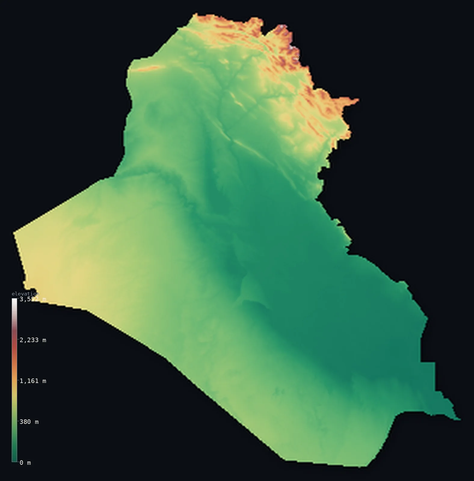
Iraq’s highest point is Cheekha Dar at 11,847 ft (3,611 m); its lowest is Persian Gulf at 0 ft (0 m); the mean elevation is 974 ft (297 m).
Iraq is the land between two rivers, and it is mostly low. The Tigris and Euphrates run the length of the country to the Persian Gulf, and around them spreads a broad alluvial plain — half of Iraq lies below 781 ft (238 m). The desert of the west and south is higher but still flat. Real mountains appear only in the far northeast, in Iraqi Kurdistan, where the Zagros rise along the borders with Iran and Turkey and the land reaches Cheekha Dar at 11,847 ft (3,611 m).
- Highest point📚
- 11,847 ft3,611 m
- Iraq's highest point is Cheekha Dar at 11,847 ft (3,611 m), in the Zagros Mountains of Iraqi Kurdistan on the border with Iran — the summit of the country's one mountainous corner, its name meaning 'Black Tent' in Kurdish. Iraq's mountains rise only here, in the northeast; everywhere else the land falls away into the plain of the two rivers and the western desert.
- Lowest point📚
- 0 ft0 m
- Iraq's lowest point is the Persian Gulf at sea level, in the far south — the outlet of the Tigris and Euphrates, where the combined rivers reach the sea through the Shatt al-Arab and the southern marshes.
- Mean elevation⚙
- 974 ft297 m
- Computed from the GLO-30 model, Iraq's mean elevation is 974 ft (297 m) — low, reflecting the country's dominant form: the vast alluvial plain of the Tigris and Euphrates and the flat western desert, with the mountains a small fraction of the whole.
- Median elevation⚙
- 781 ft238 m
- Half of Iraq lies below 781 ft (238 m) — a low median, the signature of the Tigris-Euphrates plain that fills the country.
- Elevation range📚
- 11,847 ft3,611 m
- From the Persian Gulf to the summit of Cheekha Dar, Iraq spans about 11,850 ft — but almost all of it is gained in the Kurdish northeast; across the great plain and the desert, the land barely rises.
- Above 1,000 m (3,281 ft)⚙
- 3%
- Only about 3% of Iraq rises above 1,000 m (3,281 ft) — the Zagros mountains of Iraqi Kurdistan in the far northeast, and nothing else. The great majority of the country is low plain and desert.
- Official area📚
- 169,235 mi²438,317 km²
- Iraq covers about 169,000 sq mi (438,317 sq km) — most of it the plain of the Tigris and Euphrates and the western desert, with a mountainous northeastern corner in Iraqi Kurdistan.
- Forest cover📚
- 1.9%
- About 1.9% of Iraq is forested — a small share, concentrated in the oak woodlands of the Kurdish mountains in the northeast; the plain and desert carry little but the cultivated land along the rivers.
Highest and lowest points
Iraq's highest point is Cheekha Dar, 11,847 ft (3,611 m), in the Zagros Mountains of Iraqi Kurdistan on the border with Iran. Its name means 'Black Tent' in Kurdish. It stands in the one genuinely mountainous part of the country — the northeastern corner, where the Zagros folds rise along the Iranian and Turkish frontiers, holding snow into the summer. The summit is shared with Iran, though it is not that country's high point, which lies far to the east. Everywhere else, Iraq is plain and desert.
source ↗Iraq's lowest point is the Persian Gulf at sea level, in the far south, where the Tigris and Euphrates join as the Shatt al-Arab and flow to the sea. Around it lie the southern marshes — the Mesopotamian Marshlands, once among the largest wetlands in the Middle East, a low world of reed and water at the very bottom of the country's long river plain. From here the land rises almost imperceptibly northwest, the whole plain tilting gently up toward the mountains.
source ↗Cheekha Dar is a border summit: its peak lies just outside the generalized Iraq boundary, so the highest fully in-territory land pixel in the model is 11,841 ft (3,609 m). The headline figure above is the surveyed elevation of the recognised national high point.
Iraq at a glance
Iraq's highest point, Cheekha Dar (3,611 m), means 'Black Tent' in Kurdish and stands in the Zagros on the Iranian border — all of the country's high ground is in this one northeastern corner.
source ↗About half of Iraq lies below 781 ft (238 m) — most of it the low alluvial plain of the Tigris and Euphrates, the historic Mesopotamia.
source ↗The Tigris and Euphrates run the length of Iraq and join near the south as the Shatt al-Arab before reaching the Persian Gulf.
source ↗The Mesopotamian Marshes of southern Iraq were once among the largest wetlands in the Middle East, a low world of reed and water at the bottom of the river plain.
source ↗Mesopotamia — the land between the rivers — was one of the cradles of civilization, its flat, watered plain supporting some of the earliest cities on Earth.
source ↗Outside the Kurdish mountains of the northeast, Iraq is almost entirely low — river plain in the centre and east, flat desert in the west and south.
source ↗Because Cheekha Dar straddles the Iranian border, the nearby Halgurd (3,607 m), 7 km away and fully inside Iraq, is sometimes called the country's highest wholly-Iraqi peak.
source ↗Iraq's largest lake, Lake Tharthar, covers about 2,710 km2 in the plain between the Tigris and Euphrates.
source ↗
Elevation profile of Iraq
The largest share of land, 52%, falls in the 0–250 m band, and 82% of the territory lies below 500 m (1,640 ft).
- below 500 m (1,640 ft)82%
- 500–1,000 m15%
- 1,000–2,000 m3%
- above 2,000 m (6,562 ft)<1%
Highest peaks of Iraq
| Peak | Elevation | Range | Note |
|---|---|---|---|
| Cheekha Dar↗ | 11,847 ft3,611 m | Zagros Mountains (Iran border) | Highest point of Iraq, on the Iranian border in the Zagros of Kurdistan. |
| Halgurd↗ | 11,834 ft3,607 m | Zagros Mountains (Erbil Province) | Just 7 km southwest of Cheekha Dar and entirely within Iraq - long regarded as the country's highest, and its highest wholly-domestic peak. |
| Korek Mountain↗ | 6,923 ft2,110 m | Zagros Mountains (near Rawanduz) | A prominent peak near Rawanduz reached by a cable car, a well-known viewpoint in Iraqi Kurdistan. |
The two rivers, the desert, and the Kurdish mountains
The Tigris-Euphrates plain
The heart of Iraq — the broad, flat alluvial plain built by the two rivers, running from the centre of the country down to the Gulf. This is historic Mesopotamia, low, level, and watered, holding most of the population and the great cities of Baghdad and Basra.
The western and southern desert
West and south of the rivers spreads flat, stony desert — the Syrian and Arabian deserts reaching into Iraq — higher than the river plain but still level and dry, sparsely peopled, merging into the deserts of Jordan, Syria, and Saudi Arabia.
The Kurdish mountains (northeast)
In the far northeast, in Iraqi Kurdistan, the Zagros rise along the borders with Iran and Turkey — the only true mountains in the country, folded ranges holding Cheekha Dar and snow into summer, cut by deep valleys and the headwaters of the rivers.
The southern marshes
At the bottom of the river plain, where the Tigris and Euphrates meet near the Gulf, lie the Mesopotamian Marshes — a low expanse of reed beds, lakes, and waterways, the country's lowest and wettest ground.
How to read this map
Color shows elevation; the raised relief shows real terrain. On this map Iraq reads as a broad low expanse in greens and pale browns — the river plain and the desert filling almost the whole country nearly flat — with a single concentration of brown-and-white mountains gathered in the far northeastern corner, the Kurdish Zagros.
The 3D relief is the actual GLO-30 elevation data, exaggerated vertically so both the gentle tilt of the plain and the northeastern mountains show; the ×N relief slider controls how much. Tap anywhere to read that point's exact elevation.
City elevations in Iraq
Iraq's cities line the rivers and the plain — Baghdad on the Tigris in the centre, Basra near the Gulf in the south, Mosul on the Tigris in the north — with Erbil and Sulaymaniyah up in the Kurdish highlands toward the mountains. Most sit low on the plain.
| City | Population | Elevation |
|---|---|---|
| Baghdadcapitalthe capital, on the Tigris in the centre of the alluvial plain ↗ | 7,216,000 | 138 ft42 m |
| Al Mawşil al Jadīdahon the Tigris in the north, below the Kurdish mountains ↗ | 2,065,597 | 804 ft245 m |
| Al Başrah al Qadīmahnear the Persian Gulf in the far south, on the Shatt al-Arab ↗ | 2,015,483 | 20 ft6 m |
| Karbala | 1,218,732 | 98 ft30 m |
| Kirkuk | 1,031,000 | 1,148 ft350 m |
| Sulaymaniyah | 878,146 | 2,789 ft850 m |
| Nasiriyah | 558,400 | 20 ft6 m |
| Al ‘Amārah | 323,302 | 30 ft9 m |
| Al Diwaniyah | 318,801 | 79 ft24 m |
| Al-Kut | 315,162 | 62 ft19 m |
Elevation sampled at each city centre from the Copernicus GLO-30 model. Cities and population from GeoNames (CC-BY 4.0).
Iraq in comparison
Iraq's terrain rises 11,847 ft (3,611 m) from sea level to Cheekha Dar — about 41% of the height of Mount Everest, the world's highest point at 29,032 ft (8,849 m).
- Iran's mean elevation is 4,101 ft — 3,127 ft higher; its high point, Mount Damavand, reaches 18,406 ft (5,610 m), 6,558 ft above. Iran elevation map →
- Syria's mean elevation is 1,696 ft — 722 ft higher; its high point, Mount Hermon (Jabal al-Shaykh), reaches 9,232 ft (2,814 m), 2,615 ft below. Syria elevation map →
- Saudi Arabia's mean elevation is 2,093 ft — 1,119 ft higher; its high point, Jabal Sawda, reaches 9,892 ft (3,015 m), 1,955 ft below. Saudi Arabia elevation map →
Frequently asked questions
What is the highest point in Iraq?
- Cheekha Dar, 11,847 ft (3,611 m), in the Zagros Mountains of Iraqi Kurdistan on the Iranian border — its name means 'Black Tent.' All of Iraq's high ground is in this one corner.
What is the lowest point in Iraq?
- The Persian Gulf at sea level, in the far south, where the Tigris and Euphrates reach the sea.
What is the average elevation of Iraq?
- Computed from the Copernicus GLO-30 model, the area-weighted mean is 974 ft (297 m) — low, because most of the country is the flat plain of the Tigris and Euphrates and the western desert.
Is Iraq flat?
- Mostly — half the country lies below 781 ft (238 m), the great river plain, and the western desert, though higher, is still flat. Real mountains appear only in the Kurdish northeast, where the Zagros rise.
What are the Mesopotamian Marshes?
- The wetlands at the southern end of Iraq's river plain, where the Tigris and Euphrates meet near the Gulf — once among the largest marshes in the Middle East, a low expanse of reed and water.
Is this a topographic, relief, contour, or elevation map of Iraq?
- They describe the same thing — terrain height. This page renders the country's actual elevation surface in interactive 3D and reports the statistics computed from it.
About this map
The terrain is rendered from the Copernicus GLO-30 digital elevation model (ESA), masked to the IRQ-ADM0 boundary from geoBoundaries (gbOpen). Elevation statistics are computed directly from the model; peak names and researched facts are sourced and cited. See the methodology for the full pipeline.
Our area-weighted mean, computed from the Copernicus GLO-30 model, is 974 ft (297 m); the figure commonly cited elsewhere is 1,024 ft (312 m) (CIA World Factbook). Most of Iraq is low - the Mesopotamian plain of the Tigris and Euphrates and the western and southern deserts - with high ground only in the northeastern Zagros of Kurdistan, giving a fairly low mean elevation; the page reports the area-weighted figure computed from the Copernicus GLO-30 model.
Surveyed national figures: official area · forest cover · high point.
Rendered from Copernicus GLO-30 (ESA, 2021 release), boundaries from geoBoundaries. Generated 2026-06-23.
Bordering countries · 6
Iraq shares a land border with these countries — open any one to compare its terrain and highest point.