Turkey Elevation Map — Topographic & 3D Terrain
Explore the terrain of Turkey in interactive 3D, built from Copernicus GLO-30 satellite elevation data — a high plateau held between two mountain walls. Drag to rotate, scroll to zoom, and tap any point to read its elevation.
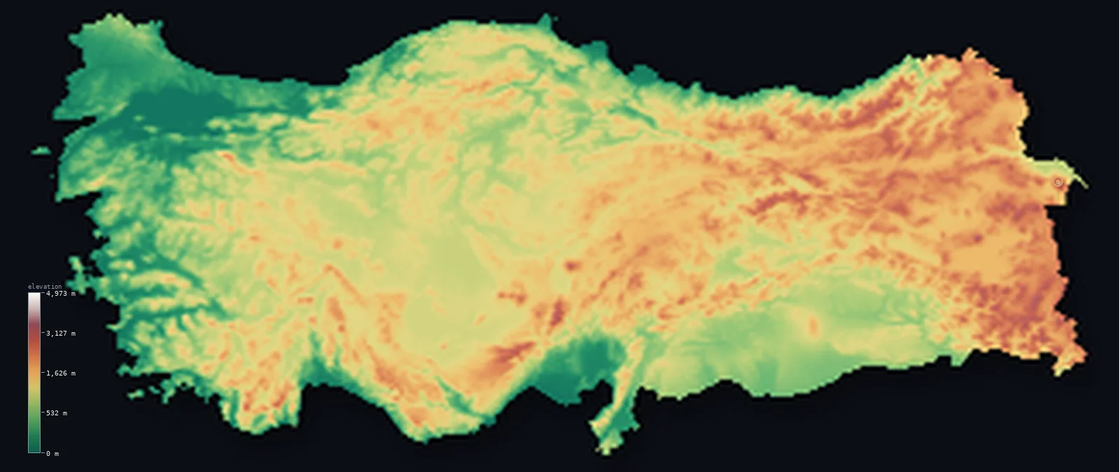
Turkey’s highest point is Mount Ararat (Agri Dagi) at 16,854 ft (5,137 m); its lowest is Mediterranean Sea at 0 ft (0 m); the mean elevation is 3,737 ft (1,139 m).
Turkey is a raised country, and it gets higher as it goes east. The Anatolian plateau fills the middle, walled in by the Pontic Mountains along the Black Sea and the Taurus along the Mediterranean, so that 82% of the country lies above 1,640 ft (500 m) and its median is nearly identical to its mean. Where those two ranges converge in the far east, the land rises into genuine highland — and above it all stands the isolated volcanic cone of Mount Ararat at 16,854 ft (5,137 m).
- Highest point📚
- 16,854 ft5,137 m
- Turkey's highest point is Mount Ararat at 16,854 ft (5,137 m), a dormant volcano standing alone above the eastern Anatolian highlands near the Armenian and Iranian borders — a snow- and ice-capped cone rising more than 3,000 m above the plain around it.
- Lowest point📚
- 0 ft0 m
- Turkey's lowest point is sea level, on coasts touching four seas — the Black Sea, the Sea of Marmara, the Aegean, and the Mediterranean — reached wherever the plateau's rim finally breaks down to the shore.
- Mean elevation⚙
- 3,737 ft1,139 m
- Turkey's mean elevation computed from the GLO-30 model is 3,737 ft (1,139 m) — high, and the straightforward consequence of Anatolia: the plateau occupies most of the country, and the eastern third stands higher still.
- Median elevation⚙
- 3,570 ft1,088 m
- Half of Turkey lies above 3,570 ft (1,088 m) — almost exactly the mean, the signature of a plateau country. Turkey is not high peaks averaged against low plains; it is uniformly raised, with the coastal lowlands only a narrow fringe.
- Elevation range📚
- 16,854 ft5,137 m
- From sea level to the summit of Ararat, Turkey spans about 16,850 ft — though the plateau does most of the work: the country is already a kilometre up across its interior before any mountain begins.
- Above 1,000 m (3,281 ft)⚙
- 57%
- About 57% of Turkey lies above 1,000 m (3,281 ft) — a majority of the country, taking in nearly the whole Anatolian plateau and all of the eastern highlands.
- Above 2,000 m (6,562 ft)⚙
- 11%
- Roughly 11% of Turkey stands above 2,000 m (6,562 ft) — concentrated in the eastern third, where the Pontic and Taurus ranges converge and the plateau itself climbs toward the Caucasus and Iran.
- Official area📚
- 302,535 mi²783,562 km²
- Turkey covers about 302,535 sq mi (783,562 sq km), spanning two continents — a small European corner in Thrace, west of the Bosphorus, and the great Asian bulk of Anatolia beyond it.
- Forest cover📚
- 28.5%
- About 29% of Turkey is forested — dense along the rainy Black Sea coast where the Pontic Mountains catch the moisture, sparse across the dry interior plateau, and thin again on the Mediterranean side.
Highest and lowest points
Turkey's highest point is Mount Ararat, 16,854 ft (5,137 m), a dormant stratovolcano in the far east near the borders with Armenia and Iran. It is a classic isolated cone, rising over 3,000 m above the surrounding plateau and carrying a permanent ice cap on its summit. That ice is why the elevation model reads it low: on this 30-metre surface the summit reads about 16,300 ft (4,973 m), a little over 3% below the surveyed height, because the glaciated crest averages down across the grid. The figure above is the surveyed elevation.
source ↗Turkey's lowest point is sea level, and it reaches the water on four seas: the Black Sea to the north, the Sea of Marmara in the middle, the Aegean to the west, and the Mediterranean to the south. The Bosphorus and Dardanelles straits cut through the country to link them, separating European Thrace from Asian Anatolia — one of the few places on Earth where a strait divides a country between two continents.
source ↗Turkey at a glance
Mount Ararat, 5,137 m, is a dormant volcano rising more than 3,000 m above the eastern Anatolian plateau - an isolated ice-capped cone near the Armenian and Iranian borders.
source ↗About 82% of Turkey lies above 500 m - the Anatolian plateau makes it one of the more elevated countries in the region, with its median elevation nearly equal to its mean.
source ↗Turkey spans two continents, with European Thrace separated from Asian Anatolia by the Bosphorus and Dardanelles straits.
source ↗The Anatolian plateau is walled in by two ranges - the Pontic Mountains along the Black Sea and the Taurus along the Mediterranean - which converge in the mountainous east.
source ↗Turkey has coastlines on four seas: the Black Sea, the Sea of Marmara, the Aegean, and the Mediterranean.
source ↗Turkey sits on the Anatolian plate, squeezed between the Arabian and Eurasian plates - which makes it one of the most earthquake-prone countries in the world.
source ↗
Elevation profile of Turkey
The largest share of land, 29%, falls in the 1,000–1,500 m band, and 82% of the territory lies above 500 m (1,640 ft).
- below 500 m (1,640 ft)18%
- 500–1,000 m25%
- 1,000–2,000 m47%
- above 2,000 m (6,562 ft)11%
Highest peaks of Turkey
| Peak | Elevation | Range | Note |
|---|---|---|---|
| Mount Ararat (Agri Dagi)↗ | 16,854 ft5,137 m | Eastern Anatolia (volcanic) | Highest point of Turkey, an ice-capped dormant volcano near the Iranian and Armenian borders. |
| Uludoruk (Resko Tepesi)↗ | 13,566 ft4,135 m | Cilo, Southeastern Taurus | The second-highest peak in Turkey, a glaciated summit of the Cilo massif in the southeast. |
| Mount Suphan (Suphan Dagi)↗ | 13,314 ft4,058 m | Eastern Anatolia (volcanic) | A dormant stratovolcano with an ice-capped summit, just north of Lake Van. |
| Kackar (Kackar Dagi)↗ | 12,917 ft3,937 m | Pontic Mountains | The highest peak of the Pontic Mountains along the Black Sea, with small glaciers. |
| Erciyes (Erciyes Dagi)↗ | 12,851 ft3,917 m | Central Anatolia (volcanic) | A great volcano overlooking Kayseri in central Anatolia, with a small receding glacier. |
Plateau, rim, and highland
The Anatolian plateau (the interior)
The heart of Turkey is a broad, dry, raised tableland typically between 800 and 1,200 m, rising gradually eastward. Ankara stands on it, and its basins and salt lakes give the interior a semi-arid character quite unlike the green coasts.
The mountain rim: Pontic and Taurus
Two ranges wall the plateau in. The Pontic Mountains run along the Black Sea coast, catching enough rain to make the northern slopes the wettest, most forested part of the country; the Taurus range does the same along the Mediterranean, dropping steeply to a narrow southern coast.
The eastern highlands and the coasts
In the far east the two ranges converge and the whole country lifts into rugged highland above 2,000 m, carrying Ararat and the headwaters of the Tigris and Euphrates. To the west, the ranges break down into river valleys running out to the Aegean, and across the straits lies the low European corner of Thrace.
How to read this map
Color shows elevation; the raised relief shows real terrain. On this map Turkey reads as a broad raised brown interior between two darker mountain rims, deepening toward white in the eastern highlands, with narrow green coastal strips on four seas.
The 3D relief is the actual GLO-30 elevation data, exaggerated vertically so the plateau's rim and the eastern rise both stand out; the ×N relief slider controls how much. Tap anywhere to read that point's exact elevation.
City elevations in Turkey
Turkish cities split between the raised interior and the coasts. Ankara sits on the Anatolian plateau at about 2,860 ft, while Istanbul straddles the Bosphorus at sea level and İzmir lies on the Aegean — the plateau cities noticeably colder and drier than the coastal ones.
| City | Population | Elevation |
|---|---|---|
| Istanbulon the Bosphorus at sea level, the strait dividing the city between Europe and Asia ↗ | 15,701,602 | 112 ft34 m |
| Ankaracapitalthe capital, on the Anatolian plateau at about 870 m ↗ | 3,517,182 | 2,858 ft871 m |
| İzmir | 2,938,292 | 394 ft120 m |
| Gaziantep | 2,222,415 | 2,766 ft843 m |
| Diyarbakır | 1,833,684 | 2,211 ft674 m |
| Adana | 1,816,750 | 102 ft31 m |
| Kayseri | 1,452,458 | 3,451 ft1,052 m |
| Konya | 1,433,861 | 3,366 ft1,026 m |
| Antalya | 1,335,002 | 207 ft63 m |
| Eskişehir | 921,630 | 2,605 ft794 m |
Elevation sampled at each city centre from the Copernicus GLO-30 model. Cities and population from GeoNames (CC-BY 4.0).
Turkey in comparison
Turkey's terrain rises 16,854 ft (5,137 m) from sea level to Mount Ararat (Agri Dagi) — about 58% of the height of Mount Everest, the world's highest point at 29,032 ft (8,849 m).
- Iran's mean elevation is 4,101 ft — 364 ft higher; its high point, Mount Damavand, reaches 18,406 ft (5,610 m), 1,552 ft above. Iran elevation map →
- Greece's mean elevation is 1,578 ft — 2,159 ft lower; its high point, Mount Olympus (Mytikas peak), reaches 9,573 ft (2,918 m), 7,280 ft below. Greece elevation map →
- Georgia's mean elevation is 4,045 ft — 308 ft higher; its high point, Shkhara, reaches 17,037 ft (5,193 m), 184 ft above. Georgia elevation map →
Frequently asked questions
What is the highest point in Turkey?
- Mount Ararat, 16,854 ft (5,137 m), a dormant ice-capped volcano in the far east near the Armenian and Iranian borders.
What is the lowest point in Turkey?
- Sea level - Turkey has coastlines on four seas: the Black Sea, the Sea of Marmara, the Aegean, and the Mediterranean.
What is the average elevation of Turkey?
- Computed from the Copernicus GLO-30 model, the area-weighted mean is 3,737 ft (1,139 m) - high, because the Anatolian plateau covers most of the country.
Is Turkey in Europe or Asia?
- Both - the small region of Thrace west of the Bosphorus is in Europe, while the great bulk of the country, Anatolia, lies in Asia.
Why is central Turkey so high?
- The interior is the Anatolian plateau, a raised tableland walled in by the Pontic Mountains to the north and the Taurus to the south, which converge into higher country in the east.
Is this a topographic, relief, contour, or elevation map of Turkey?
- They describe the same thing - terrain height. This page renders the country's actual elevation surface in interactive 3D and reports the statistics computed from it.
About this map
The terrain is rendered from the Copernicus GLO-30 digital elevation model (ESA), masked to the TUR-ADM0 boundary from geoBoundaries (gbOpen). Elevation statistics are computed directly from the model; peak names and researched facts are sourced and cited. See the methodology for the full pipeline.
This map renders 780,053 km² across 817 landmasses of Turkey. One smaller outlying part — 0 km² in total — lies beyond the area shown here. Area statistics above count the full territory.
Our area-weighted mean, computed from the Copernicus GLO-30 model, is 3,737 ft (1,139 m); the figure commonly cited elsewhere is 3,714 ft (1,132 m) (CIA World Factbook). Most of Turkey is the high Anatolian plateau, rimmed by the Pontic and Taurus ranges and rising to the eastern highlands, with lowlands only along the coasts - so its mean elevation is high; the page reports the area-weighted figure computed from the Copernicus GLO-30 model.
Surveyed national figures: official area · forest cover · high point.
Rendered from Copernicus GLO-30 (ESA, 2021 release), with NASADEM (NASA/USGS) over a Copernicus GLO-30 coverage gap at the high point, boundaries from geoBoundaries. Generated 2026-07-21.
Bordering countries · 8
Turkey shares a land border with these countries — open any one to compare its terrain and highest point.