Armenia Elevation Map — Topographic & 3D Terrain
Explore the terrain of Armenia in interactive 3D, built from Copernicus GLO-30 satellite elevation data — a high, landlocked country of volcanic plateaus and mountains in the Lesser Caucasus. Drag to rotate, scroll to zoom, and tap any point to read its elevation.
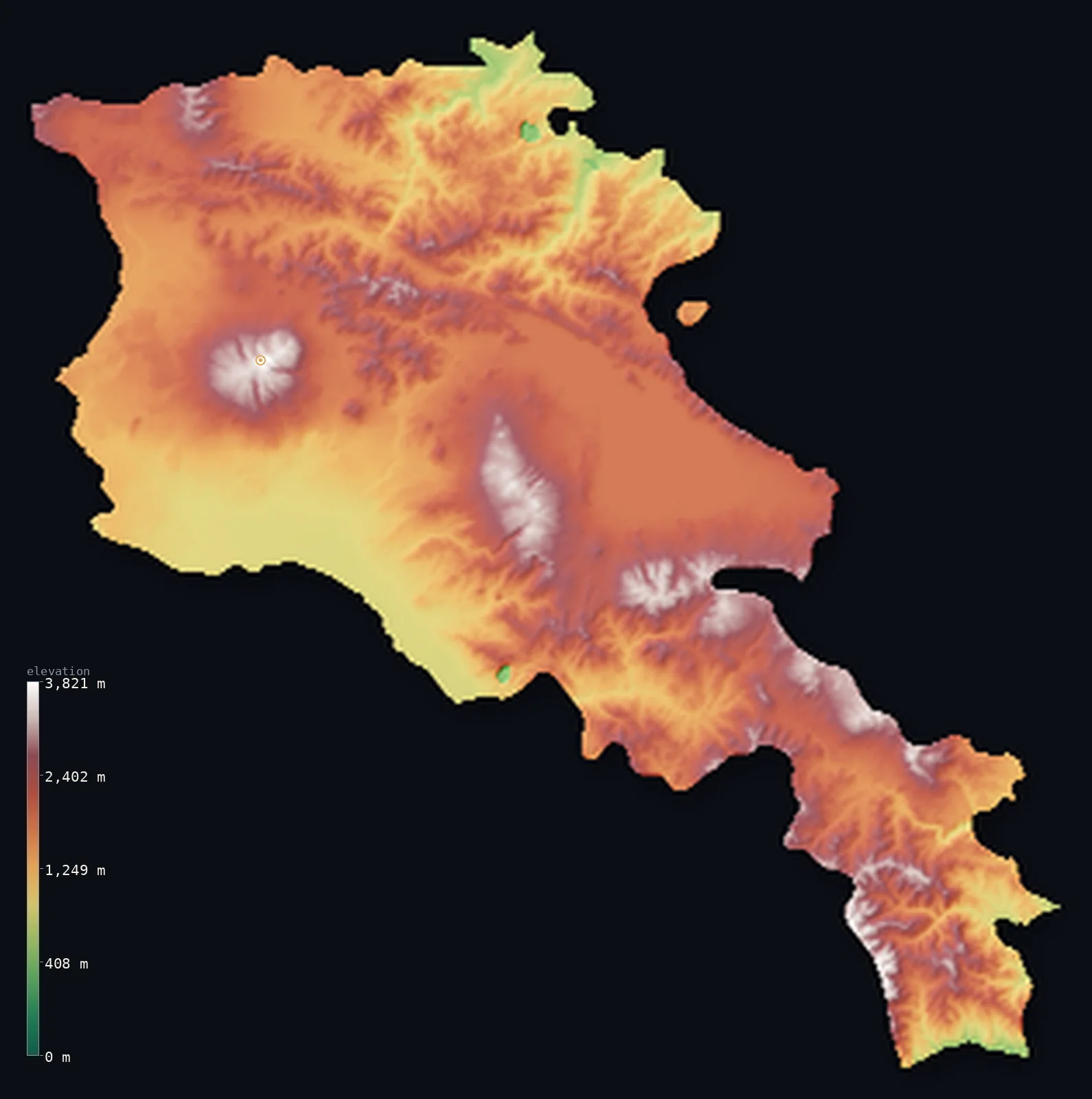
Armenia’s highest point is Mount Aragats at 13,419 ft (4,090 m); its lowest is Debed River valley at 1,312 ft (400 m); the mean elevation is 6,070 ft (1,850 m).
Armenia is a high, landlocked, mountainous country in the Lesser Caucasus — one of the highest countries in the region, lying almost entirely on a rugged volcanic plateau. There is little low ground anywhere: the land is a tumble of mountains, high plateaus, and deep river gorges, and more than half of it lies above about 6,224 ft (1,897 m). Its highest point, Mount Aragats, an extinct volcano, reaches 13,419 ft (4,090 m). The Armenian Highland is volcanic country — old lava plateaus, cinder cones, and the great blue expanse of Lake Sevan, one of the highest large lakes in the world, set high among the mountains. Only the deep gorges of rivers like the Debed, in the north, drop to lower ground.
- Highest point📚
- 13,419 ft4,090 m
- Armenia's highest point is Mount Aragats at 13,419 ft (4,090 m), an isolated extinct volcano with four peaks around a central crater, rising above the plateau in the west of the country. It is the highest point in Armenia and the high summit of the Armenian Highland — a massive volcanic mountain, snow-capped much of the year, standing well above the already-high plateaus around it. Armenia is volcanic country, and Aragats is its greatest volcano.
- Lowest point📚
- 1,312 ft400 m
- Armenia's lowest point is in the valley of the Debed River, in the far north where the river crosses into Georgia, at about 1,312 ft (400 m) above sea level. Even this, Armenia's lowest ground, is well above sea level — for Armenia is a high country, and its 'low' points are deep river gorges cut into a plateau that mostly lies far higher. There is no true lowland anywhere in Armenia.
- Mean elevation⚙
- 6,070 ft1,850 m
- Computed from the GLO-30 model, Armenia's mean elevation is 6,070 ft (1,850 m) — a high figure, for Armenia lies almost entirely on a high volcanic plateau in the Lesser Caucasus. Remarkably, the median is even higher: more than half the country lies above about 6,224 ft (1,897 m), because the high plateau is the rule and the low river gorges the exception.
- Median elevation⚙
- 6,224 ft1,897 m
- More than half of Armenia lies above about 6,224 ft (1,897 m) — and, tellingly, this is higher than the mean, because Armenia is a uniformly high country: the volcanic plateau covers most of it, sitting high, while only the deep, narrow river gorges drop to lower ground and pull the average down. The typical point in Armenia is high plateau.
- Elevation range📚
- 12,106 ft3,690 m
- From the Debed gorge in the north to the summit of Mount Aragats at 4,090 m, Armenia's terrain spans about 12,100 ft — but there is little low ground: Armenia is high throughout, a volcanic plateau cut by gorges, rising to the great volcano of Aragats, with even its lowest valleys far above the sea.
- Above 1,000 m (3,281 ft)⚙
- 90%
- About 90% of Armenia rises above 1,000 m (3,281 ft) — nearly all of it, for Armenia lies almost wholly on a high plateau. Only the deep river gorges, like the Debed in the north, drop below. It is one of the highest countries in the region.
- Above 2,000 m (6,562 ft)⚙
- 39%
- Roughly 39% of Armenia stands above 2,000 m (6,562 ft) — a large share, for much of the volcanic plateau sits above that height, rising to the high peaks and to Aragats. Armenia is high country throughout.
- Official area📚
- 11,484 mi²29,743 km²
- Armenia covers about 11,484 sq mi (29,743 sq km) — a high, landlocked country in the Lesser Caucasus, lying almost entirely on a rugged volcanic plateau of lava fields, cinder cones, and deep river gorges, rising to the extinct volcano of Mount Aragats and holding the high Lake Sevan, with little low ground anywhere.
- Forest cover📚
- 12%
- About 12% of Armenia is forested — a fairly lightly wooded country, with forest mostly in the north and northeast (oak, beech, and hornbeam on the mountain slopes), and much of the high plateau under alpine meadow, steppe, and bare volcanic rock.
Highest and lowest points
Armenia's highest point is Mount Aragats, 13,419 ft (4,090 m), an isolated extinct volcano in the west of the country — a massive mountain with four separate peaks arranged around a central crater, the highest of them the northern summit. Aragats rises well above the surrounding volcanic plateau, snow-capped for much of the year, its slopes a landscape of lava and alpine meadow. It is the highest point in present-day Armenia and one of the great volcanoes of the Armenian Highland. (The higher and more famous Mount Ararat — the snow-capped cone that is Armenia's national symbol — stands just across the border in Turkey, and is not the country's highest point, though it dominates the skyline of the capital, Yerevan.) Armenia is volcanic country throughout, high plateau rising to high peaks, and Aragats is its summit.
source ↗Armenia's lowest point is in the gorge of the Debed River in the far north, where it flows out into Georgia, at about 1,312 ft (400 m) above sea level — and even this is high, for Armenia has no true lowland at all. The country lies on the Armenian Highland, a high volcanic plateau in the Lesser Caucasus: a rugged land of old lava plateaus, cinder cones and extinct volcanoes, high basins, and deep river gorges. Its highest point, Mount Aragats, is a great four-peaked extinct volcano (4,090 m) rising in the west. Near the center lies Lake Sevan, one of the highest large freshwater lakes in the world, a vast blue expanse set high among the mountains. The plateau sits high throughout, and only where rivers — the Debed, the Hrazdan, the Vorotan — have cut deep gorges does the land drop lower. To the southwest, across the Aras River (the border with Turkey), stands Mount Ararat — the great snow-capped volcano, the national symbol of Armenia, though it lies just outside the modern country. So Armenia is high volcanic country from edge to edge, its lowest ground a northern river gorge still far above the sea. (Terrain is shown following Armenia's internationally recognized borders.)
source ↗Armenia at a glance
Armenia is one of the highest countries in its region - lying almost entirely on a volcanic plateau, with more than half the country above 1,900 m and no true lowland anywhere.
source ↗Armenia's highest point, Mount Aragats (4,090 m), is an extinct volcano with four peaks around a central crater.
source ↗So high and uniform is Armenia that its median elevation is higher than its mean - the high volcanic plateau is the rule, and only deep river gorges drop lower.
source ↗Lake Sevan, high in the mountains of Armenia, is one of the highest large freshwater lakes in the world - a vast blue expanse set on the volcanic plateau.
source ↗Mount Ararat, the snow-capped volcano that is Armenia's national symbol, dominates the skyline of the capital Yerevan - though it lies just across the border, in Turkey.
source ↗The Armenian Highland is volcanic country - old lava plateaus, cinder cones, and extinct volcanoes - cut by the deep gorges of rivers like the Debed.
source ↗
Elevation profile of Armenia
The largest share of land, 19%, falls in the 1,750–2,000 m band, and >99% of the territory lies above 500 m (1,640 ft).
- below 500 m (1,640 ft)<1%
- 500–1,000 m10%
- 1,000–2,000 m51%
- above 2,000 m (6,562 ft)39%
Highest peaks of Armenia
| Peak | Elevation | Range | Note |
|---|---|---|---|
| Mount Aragats↗ | 13,419 ft4,090 m | Armenian Highland (volcanic) | Highest point of Armenia and the Lesser Caucasus; a four-summited extinct volcano. |
| Kaputjugh↗ | 12,815 ft3,906 m | Zangezur Mountains | Highest peak of the Zangezur range in southern Syunik, on the historic border with Nakhchivan. |
| Azhdahak↗ | 11,801 ft3,597 m | Geghama Mountains | Highest peak of the Geghama volcanic range east of Yerevan, with a crater lake at its summit. |
| Spitakasar↗ | 11,663 ft3,555 m | Geghama Mountains | One of the high summits of the Geghama range overlooking Lake Sevan. |
| Mets Ishkhanasar↗ | 11,654 ft3,552 m | Syunik Highland | A high volcanic peak of the Syunik highland in the far south. |
| Vardenis (Vardenis Range high point)↗ | 11,555 ft3,522 m | Vardenis Mountains | A high volcanic massif south of Lake Sevan. |
Armenia: the volcanic plateau, the high peaks and Lake Sevan, and the river gorges
The volcanic plateau
Most of Armenia is high volcanic plateau — old lava fields, cinder cones, and high basins of the Armenian Highland, sitting high throughout, rising to extinct volcanoes like Aragats (the high point). The high, rugged heart of the country.
The high peaks and Lake Sevan
Rising from the plateau are the high volcanic peaks — Aragats in the west, the Geghama and other ranges — and, near the center, Lake Sevan, one of the world's highest large lakes, set high among the mountains. Armenia's high crown and great lake.
The river gorges — the north and south
Cutting into the plateau are deep river gorges — the Debed in the north (holding the country's lowest point), the Vorotan and others in the south — dropping to lower, forested ground. Armenia's low ground, such as it is.
How to read this map
Color shows elevation; the raised relief shows real terrain. On this map Armenia reads as a high country throughout — a broad expanse of high plateau tone across nearly all of it, rising to the browns and whites of Mount Aragats in the west and the volcanic peaks, with the blue of high Lake Sevan near the center, and only the deep river gorges (the Debed in the north) cutting down to lower ground.
Because the whole country is high, the 3D exaggeration is what makes the volcanoes and gorges stand out from the plateau; the ×N relief slider controls how much. Tap anywhere to read that point's exact elevation.
City elevations in Armenia
Armenia's cities lie on the plateau and in the valleys — Yerevan, the capital, in the west below Mount Aragats and facing Ararat across the border, with Gyumri in the northwest and Vanadzor in the north. All sit high, on or among the volcanic uplands.
| City | Population | Elevation |
|---|---|---|
| Yerevancapitalthe capital, on the plateau in the west, facing Mount Ararat across the Turkish border ↗ | 1,144,700 | 3,251 ft991 m |
| Gyumriin the northwest, on the Shirak plateau ↗ | 114,667 | 5,082 ft1,549 m |
| Vanadzorin the north, in the Debed basin ↗ | 78,100 | 4,429 ft1,350 m |
| Hrazdanin the central highlands, on the Hrazdan River ↗ | 49,500 | 5,597 ft1,706 m |
| Kapanin the far south, in the Syunik mountains ↗ | 32,900 | 2,822 ft860 m |
| Armaviron the western plain near the Turkish border ↗ | 29,700 | 2,858 ft871 m |
| Artashaton the Ararat plain south of Yerevan ↗ | 22,800 | 2,726 ft831 m |
| Ijevanin the forested northeast ↗ | 19,500 | 2,303 ft702 m |
| Gavarin the highlands by Lake Sevan ↗ | 18,900 | 6,411 ft1,954 m |
| Goris | 17,592 | 4,649 ft1,417 m |
Elevation sampled at each city centre from the Copernicus GLO-30 model. Cities and population from GeoNames (CC-BY 4.0).
Armenia in comparison
Armenia's terrain rises 12,106 ft (3,690 m) from Debed River valley (1,312 ft (400 m)) to Mount Aragats — about 42% of the height of Mount Everest, the world's highest point at 29,032 ft (8,849 m).
- Georgia's mean elevation is 4,045 ft — 2,024 ft lower; its high point, Shkhara, reaches 17,037 ft (5,193 m), 3,619 ft above. Georgia elevation map →
- Tajikistan's mean elevation is 9,688 ft — 3,619 ft higher; its high point, Ismoil Somoni Peak, reaches 24,590 ft (7,495 m), 11,171 ft above. Tajikistan elevation map →
- Switzerland's mean elevation is 4,301 ft — 1,768 ft lower; its high point, Dufourspitze (Monte Rosa), reaches 15,203 ft (4,634 m), 1,785 ft above. Switzerland elevation map →
Frequently asked questions
What is the highest point in Armenia?
- Mount Aragats, 13,419 ft (4,090 m), an extinct four-peaked volcano in the west - the highest point in present-day Armenia. (The higher Mount Ararat, Armenia's national symbol, lies just across the border in Turkey.)
What is the lowest point in Armenia?
- The gorge of the Debed River in the far north, about 1,312 ft (400 m) above sea level - and even that is high, for Armenia has no true lowland.
What is the average elevation of Armenia?
- Computed from the Copernicus GLO-30 model, the area-weighted mean is 6,070 ft (1,850 m) - and the median is even higher (6,224 ft (1,897 m)), because Armenia is a uniformly high volcanic plateau, with only deep gorges dropping lower.
Why is Armenia's median elevation higher than its mean?
- Because the country is uniformly high - the volcanic plateau covers most of it and sits high, so the typical point is high, while only narrow, deep river gorges drop low enough to pull the average down below the midpoint.
Is Mount Ararat in Armenia?
- No - though it is Armenia's national symbol and towers over the capital Yerevan, Mount Ararat lies just across the border, in Turkey. Armenia's own highest point is Mount Aragats.
Is this a topographic, relief, contour, or elevation map of Armenia?
- They describe the same thing - terrain height. This page renders the country's actual elevation surface in interactive 3D and reports the statistics computed from it.
About this map
The terrain is rendered from the Copernicus GLO-30 digital elevation model (ESA), masked to the ARM-ADM0 boundary from geoBoundaries (gbOpen). Elevation statistics are computed directly from the model; peak names and researched facts are sourced and cited. See the methodology for the full pipeline.
Our area-weighted mean, computed from the Copernicus GLO-30 model, is 6,070 ft (1,850 m); the figure commonly cited elsewhere is 5,879 ft (1,792 m) (CIA World Factbook). Armenia is a high country almost without low ground. It lies on the Armenian Highland — a rugged volcanic plateau of old lava fields, cinder cones, and high basins, set among the mountains of the Lesser Caucasus — and this high plateau is the rule across nearly the whole country. So high is it, and so uniformly, that the median elevation is actually higher than the mean: more than half of Armenia lies above about 6,224 ft (1,897 m), and only the deep, narrow river gorges — like the Debed in the north — drop to lower ground, pulling the average down below the typical point. The volcano Aragats is the high crown; Lake Sevan sits high among the mountains; and there is no true lowland anywhere.
Surveyed national figures: official area · forest cover · high point.
Rendered from Copernicus GLO-30 (ESA, 2021 release), with NASADEM (NASA/USGS) over the Armenia/Azerbaijan coverage gap, boundaries from geoBoundaries. Generated 2026-07-18.
Bordering countries · 4
Armenia shares a land border with these countries — open any one to compare its terrain and highest point.