Qatar Elevation Map — Topographic & 3D Terrain
Explore the terrain of Qatar in interactive 3D, built from Copernicus GLO-30 satellite elevation data — one of the flattest countries on Earth, a low desert peninsula barely above the Persian Gulf. Drag to rotate, scroll to zoom, and tap any point to read its elevation.
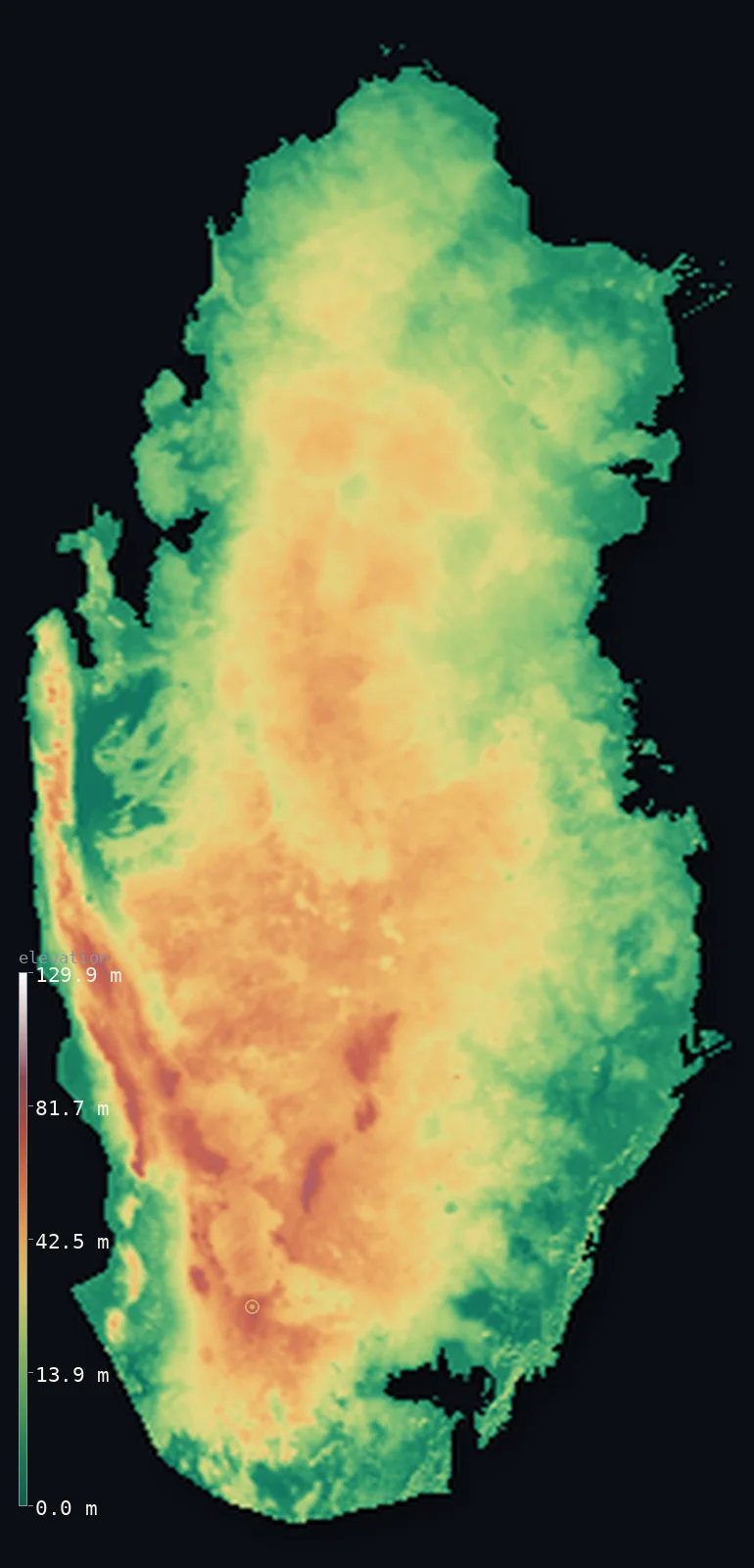
Qatar’s highest point is Qurayn Abu al Bawl at 338 ft (103 m); its lowest is Persian Gulf at 0 ft (0 m); the mean elevation is 84 ft (25.5 m).
Qatar is one of the flattest countries on Earth — a low, rocky desert peninsula reaching north into the Persian Gulf. It barely rises above the sea: half the country lies below about 77 ft (23.6 m), and its highest point, Qurayn Abu al Bawl in the south, reaches only 338 ft (103 m) — a hill, not a mountain. The only relief is modest: the low Dukhan ridge of limestone along the west coast, over the main oil field, and a scatter of southern hills. Elsewhere the plain rolls almost level to a coast of salt flats and, in the southeast, the Khor Al Adaid, where the Gulf reaches into a field of tall dunes.
- Highest point📚
- 338 ft103 m
- Qatar's highest point is Qurayn Abu al Bawl, at just 338 ft (103 m) — a low, isolated desert hill (also called Tuwayyir al Hamir) among the rocky plain in the south of the peninsula, near the Saudi border. Qatar has no mountains; its 'summit' is a modest rise.
- Lowest point📚
- 0 ft0 m
- Qatar's lowest point is sea level, along the Persian Gulf that surrounds the peninsula on three sides — a coast of salt flats (sabkha) and low cliffs, with the capital, Doha, barely 10 m above the water.
- Mean elevation⚙
- 84 ft25.5 m
- Computed from the GLO-30 model, Qatar's mean elevation is 84 ft (25.5 m) — among the lowest of any country, for Qatar is a low, flat desert peninsula barely above the Gulf. Half the country lies below about 77 ft (23.6 m); the land rises only to about 103 m in a few scattered hills.
- Median elevation⚙
- 77 ft23.6 m
- Half of Qatar lies below about 77 ft (23.6 m) — the peninsula is a low, near-level desert plain, rising only gently from the Gulf to a scatter of modest hills, the highest just 103 m.
- Elevation range📚
- 338 ft103 m
- From the Gulf to just 103 m at Qurayn Abu al Bawl, Qatar's terrain spans only about 338 ft — one of the smallest elevation ranges of any country, a near-flat peninsula of rocky desert.
- Above 50 m (164 ft)⚙
- 10%
- About 10% of Qatar rises above 50 m (164 ft) — the low Dukhan ridge along the west coast, over the country's main oil field, and the scattered southern hills that include Qurayn Abu al Bawl. The rest of the peninsula is a near-level plain barely above the Gulf.
- Official area📚
- 4,473 mi²11,586 km²
- Qatar covers about 4,473 sq mi (11,586 sq km) — a small, flat desert peninsula reaching north into the Persian Gulf, its only land border with Saudi Arabia across the south.
- Forest cover📚
- 0%
- Essentially none of Qatar is forested — the peninsula is arid desert throughout, its little vegetation gathered in shallow depressions (rawdas) that trap what rain falls.
Highest and lowest points
Qatar's highest point is Qurayn Abu al Bawl — also known as Tuwayyir al Hamir — at just 338 ft (103 m), a low isolated hill among the rocky desert plain in the south of the peninsula, near the Saudi border. On a country this flat, it is a modest rise rather than a mountain; its name is said to come from a traditional flat-shaped toy the hill resembles. The land falls away almost imperceptibly from here across a near-level desert to the Gulf coast on every side.
source ↗Qatar's lowest ground is its coastline, at sea level, wrapping the peninsula on three sides — a shore of salt flats (sabkha), low cliffs, and, in the southeast, the Khor Al Adaid 'Inland Sea', where the Gulf reaches deep into a field of tall sand dunes. Inland, the land rises so gently it is hard to see: a low, barren limestone and gravel plain, dotted with shallow depressions (rawdas) that gather what little water there is. The only real relief is the low Dukhan ridge along the west coast, over the main onshore oil field, and the scattered southern hills, where Qurayn Abu al Bawl reaches Qatar's high point of just 103 m.
source ↗Qatar at a glance
Qatar's highest point, Qurayn Abu al Bawl, is only 103 m - barely a hill, in a country that is almost entirely flat.
source ↗The name 'Abu al Bawl' comes from a traditional flat-shaped toy, the balboul, which the hill is thought to resemble.
source ↗Qatar's average elevation is among the lowest of any country - a near-level desert peninsula barely above the Gulf.
source ↗In the southeast, the Khor Al Adaid 'Inland Sea' is one of the few places on Earth where the sea reaches deep into a field of tall sand dunes.
source ↗Qatar has just one land border - with Saudi Arabia, across the south of the peninsula.
source ↗
Elevation profile of Qatar
The largest share of land, 25%, falls in the 0–10 m band, and 100% of the territory lies below 500 m (1,640 ft).
- 0–10 m (0–33 ft)26%
- 10–50 m (33–164 ft)64%
- above 50 m (164 ft)10%
Highest peaks of Qatar
| Peak | Elevation | Range | Note |
|---|---|---|---|
| Qurayn Abu al Bawl (Tuwayyir al Hamir)↗ | 338 ft103 m | Southern hills | Highest point of Qatar, a low isolated desert hill in the south near the Saudi border. |
| Jebel Dukhan↗ | 322 ft98 m | Dukhan anticline (west coast) | A low limestone ridge along the west coast, rising to around 100 m over the Dukhan oil field. |
Qatar: the desert plain, the Dukhan ridge and southern hills, and the coast
The flat desert plain
Qatar is a low, flat peninsula of barren limestone and gravel desert, rising gently from the east coast to a central plateau rarely more than a few tens of metres above the sea. Shallow depressions called rawdas gather rainwater and support what little vegetation exists, mostly in the east near the coast.
The Dukhan ridge and southern hills
The only real relief is modest. Along the west coast the Dukhan anticline rises as a chain of low limestone hills up to about 100 m, beneath which lies Qatar's main onshore oil field. In the south, isolated conical hills include Qurayn Abu al Bawl (103 m), the country's highest point.
The coast, salt flats and dunes
The long coastline is fringed by salt flats (sabkha) and low cliffs. In the southeast, the Khor Al Adaid — an inlet of the Gulf known as the 'Inland Sea' — is surrounded by large mobile sand dunes, a rare setting where the desert meets the sea.
How to read this map
Color shows elevation; the raised relief shows real terrain. On this map Qatar reads as almost uniformly low — a near-level desert peninsula barely tinted above sea level, its highest ground only faint rises: the Dukhan ridge along the west coast and the scattered southern hills around Qurayn Abu al Bawl.
Because the whole country stands only about 100 m above the sea, the 3D relief is the actual GLO-30 elevation data exaggerated strongly so any relief shows at all; the ×N relief slider controls how much. Tap anywhere to read that point's exact elevation.
City elevations in Qatar
Qatar's towns cluster on the coast and in the interior desert — Doha, the capital, on the central east coast, with Dukhan on the west coast over the oil field and Madinat ash Shamal in the far north. Almost everyone lives on the low coast.
| City | Population | Elevation |
|---|---|---|
| Dohacapitalthe capital, on the central east coast, only about 10 m above the Gulf ↗ | 344,939 | 23 ft7 m |
| Az̧ Z̧a‘āyin | 54,339 | 20 ft6 m |
| Umm Ghuwaylīnah | 39,457 | 108 ft33 m |
| Umm Şalāl Muḩammad | 29,391 | 72 ft22 m |
| Ash Shīḩānīyah | 8,380 | 138 ft42 m |
| Dukhānon the west coast, along the low Dukhan ridge over the country's main oil field ↗ | 7,250 | 102 ft31 m |
| Musay‘īd | 5,769 | 20 ft6 m |
| Madīnat ash Shamāl | 5,267 | 23 ft7 m |
| Umm Bāb | 2,500 | 180 ft55 m |
| Al Ghuwayrīyah | 2,332 | 62 ft19 m |
Elevation sampled at each city centre from the Copernicus GLO-30 model. Cities and population from GeoNames (CC-BY 4.0).
Qatar in comparison
Qatar's terrain rises 338 ft (103 m) from sea level to Qurayn Abu al Bawl — about 1% of the height of Mount Everest, the world's highest point at 29,032 ft (8,849 m).
- Bahrain's mean elevation is 46 ft — 38 ft lower; its high point, Jabal ad Dukhan (Mountain of Smoke), reaches 440 ft (134 m), 102 ft above. Bahrain elevation map →
- United Arab Emirates's mean elevation is 384 ft — 300 ft higher; its high point, Jebel Jais (UAE high point), reaches 6,207 ft (1,892 m), 5,869 ft above. United Arab Emirates elevation map →
- Kuwait's mean elevation is 381 ft — 297 ft higher; its high point, Unnamed location (western Kuwait), reaches 1,004 ft (306 m), 666 ft above. Kuwait elevation map →
Frequently asked questions
What is the highest point in Qatar?
- Qurayn Abu al Bawl, 338 ft (103 m) - a low desert hill in the south, also known as Tuwayyir al Hamir. Qatar has no mountains.
What is the average elevation of Qatar?
- Computed from the Copernicus GLO-30 model, the area-weighted mean is 84 ft (25.5 m) - among the lowest of any country, as Qatar is almost entirely flat.
What is the lowest point in Qatar?
- Sea level, along the Persian Gulf that surrounds the peninsula on three sides.
Is Qatar completely flat?
- Nearly - it is a low desert plain rising only to about 100 m in the Dukhan ridge on the west coast and the southern hills, where Qurayn Abu al Bawl reaches 103 m.
What is Khor Al Adaid?
- The 'Inland Sea' in Qatar's southeast - an inlet of the Persian Gulf ringed by tall sand dunes, a rare place where the sea reaches into a dune field.
Is this a topographic, relief, contour, or elevation map of Qatar?
- They describe the same thing - terrain height. This page renders Qatar's actual elevation surface in interactive 3D (a relief or topographic view) and reports the elevation statistics computed from it; on such flat terrain the relief is subtle.
About this map
The terrain is rendered from the Copernicus GLO-30 digital elevation model (ESA), masked to the QAT-ADM0 boundary from geoBoundaries (gbOpen). Elevation statistics are computed directly from the model; peak names and researched facts are sourced and cited. See the methodology for the full pipeline.
Our area-weighted mean, computed from the Copernicus GLO-30 model, is 84 ft (25.5 m); the figure commonly cited elsewhere is 92 ft (28 m) (CIA World Factbook). Qatar is one of the flattest countries on Earth. A low, rocky desert peninsula jutting north into the Persian Gulf, it barely rises above the sea: half the country lies below about 77 ft (23.6 m), and its highest point, Qurayn Abu al Bawl in the south, reaches only 103 m — a hill, not a mountain. The only relief is modest: the low Dukhan ridge of limestone along the west coast, beneath which lies the main oil field, and a scatter of southern hills. Elsewhere the plain rolls almost level to a coast of salt flats and, in the southeast, the Khor Al Adaid, where the Gulf reaches into a field of tall dunes.
Surveyed national figures: official area · forest cover · high point.
Rendered from Copernicus GLO-30 (ESA, 2021 release), boundaries from geoBoundaries. Generated 2026-06-26.
Bordering countries · 1
Qatar shares a land border with these countries — open any one to compare its terrain and highest point.