United Arab Emirates Elevation Map — Topographic & 3D Terrain
Explore the terrain of the United Arab Emirates in interactive 3D, built from Copernicus GLO-30 satellite elevation data — a low country of coast and sand desert, with the Hajar Mountains in the far northeast. Drag to rotate, scroll to zoom, and tap any point to read its elevation.
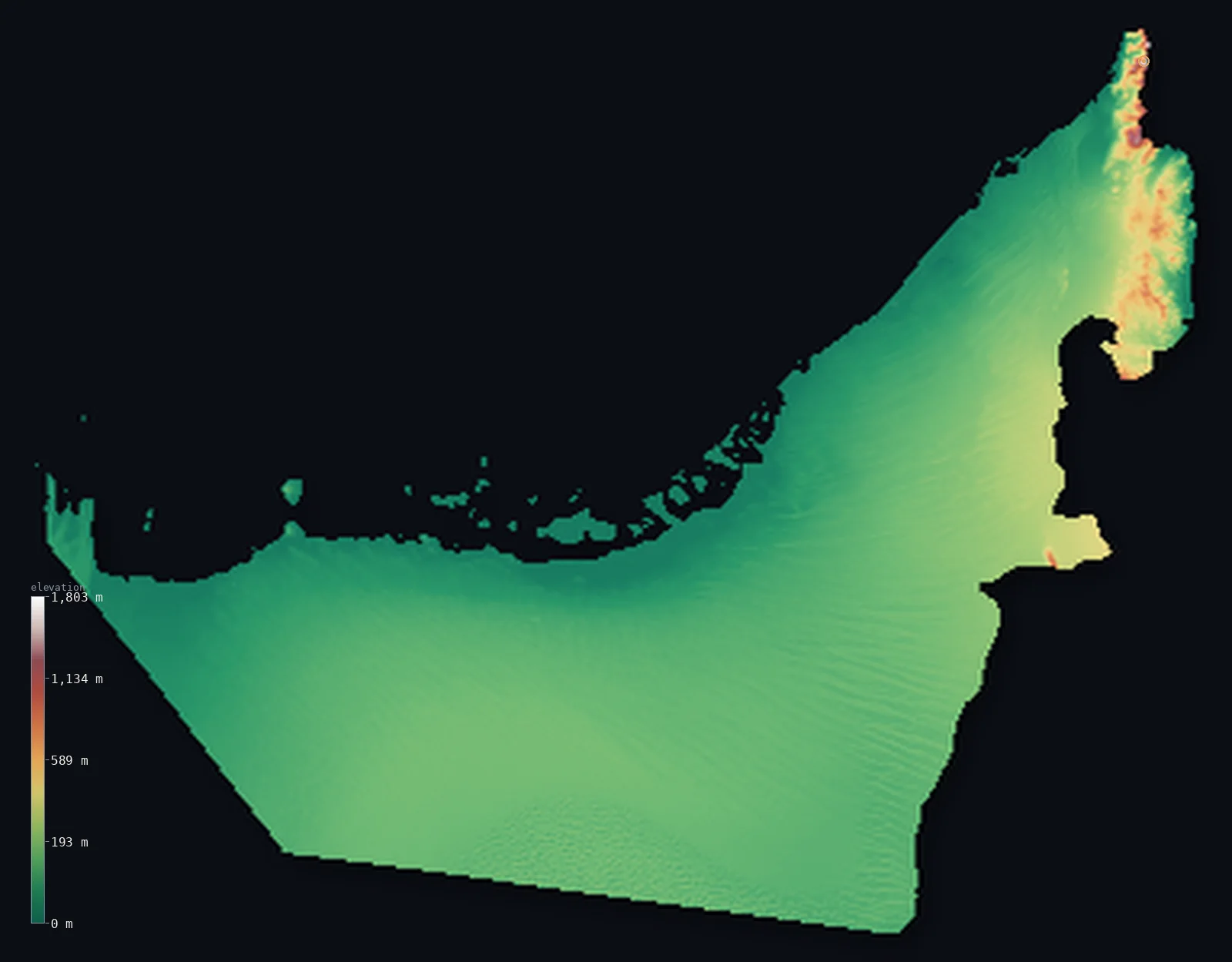
United Arab Emirates’s highest point is Jebel Jais (UAE high point) at 6,207 ft (1,892 m); its lowest is Persian Gulf at 0 ft (0 m); the mean elevation is 384 ft (117 m).
The United Arab Emirates is a low country. Most of it is flat — the low Persian Gulf coast, where the cities crowd, and the great sand sea of the Rub' al Khali, the Empty Quarter, rolling across the south — so half the country lies below about 361 ft (110 m). The only real height is in one corner: the Hajar Mountains along the eastern border with Oman, climbing to the Jebel Jais massif, whose highest UAE ground is about 6,207 ft (1,892 m) (the true 1,934 m summit is just over the line in Oman). Away from that corner, the land falls quickly to desert and the flat coast.
- Highest point📚
- 6,207 ft1,892 m
- The highest ground in the United Arab Emirates is on the Jebel Jais massif, about 6,207 ft (1,892 m), in the Ru'us al-Jibal — the northern Hajar Mountains — on the Omani border in Ras al-Khaimah. The massif's true 1,934 m summit stands just across the border in Oman; the highest point inside the UAE is a ridge a little to the west.
- Lowest point📚
- 0 ft0 m
- The UAE's lowest point is sea level, along the Persian Gulf coast in the west and north and the Gulf of Oman in the east. Most of the country is only a few metres above the sea — a low coast of sand and salt flats.
- Mean elevation⚙
- 384 ft117 m
- Computed from the GLO-30 model, the UAE's mean elevation is 384 ft (117 m) — low, for the country is mostly flat: the low Gulf coast and the great Rub' al Khali sand desert. Half of it lies below about 361 ft (110 m); high ground is confined to the Hajar Mountains along the Omani border in the far northeast.
- Median elevation⚙
- 361 ft110 m
- Half of the UAE lies below about 361 ft (110 m) — the country is low and level, coast and sand desert, rising only in the far northeast where the Hajar Mountains reach Jebel Jais on the Omani border.
- Elevation range📚
- 6,207 ft1,892 m
- From the sea to about 1,892 m on the Jebel Jais massif, the UAE's terrain spans about 6,207 ft — but almost all of that rise is packed into one northeastern corner; the rest of the country is low coast and desert.
- Above 1,000 m (3,281 ft)⚙
- <1%
- <1% of the UAE rises above 1,000 m (3,281 ft) — only the Hajar Mountains in the far northeast, on the Omani border, reaching Jebel Jais; the rest of the country is low coast and sand desert.
- Official area📚
- 32,278 mi²83,600 km²
- The United Arab Emirates covers about 32,278 sq mi (83,600 sq km) — a mostly low country of flat Gulf coast, the great Rub' al Khali sand desert across the south, and the Hajar Mountains along the eastern border with Oman.
- Forest cover📚
- 4.5%
- About 4.5% of the UAE is counted as forested — largely planted, for the natural land is desert, coast and bare mountain, with mangroves along the Gulf shore and irrigated greenery around the cities and Al Ain.
Highest and lowest points
The highest ground in the United Arab Emirates is on the Jebel Jais massif, about 6,207 ft (1,892 m), in the northern Hajar Mountains (the Ru'us al-Jibal) in Ras al-Khaimah, on the border with Oman. The massif's true summit, 1,934 m, stands just across the frontier in Oman; the highest point within the UAE is a ridge a little to the west, so it is a frontier high point rather than a true peak. Snow can dust it in winter, a rarity in the desert UAE, and its slopes carry the world's longest zip-line. Away from this one mountainous corner, the country falls quickly to low desert and the flat Gulf coast.
source ↗The UAE's lowest ground is its coastline — the Persian Gulf in the west and north, the Gulf of Oman in the east — all at sea level, fringed by low salt flats (sabkha), lagoons and islands where most Emiratis live, in Abu Dhabi, Dubai and the coastal cities. Inland the land rises gently into gravel and sand desert that swells southward into the great dunes of the Rub' al Khali, the Empty Quarter. The isolated ridge of Jebel Hafit rises near Al Ain in the east. Only in the far northeast, along the Omani border, do real mountains stand — the bare rock of the Hajar, rising to the Jebel Jais massif (about 1,892 m within the UAE), the country's highest ground, below the 1,934 m summit that lies in Oman.
source ↗United Arab Emirates at a glance
The true summit of Jebel Jais (1,934 m) lies in Oman; the highest ground inside the UAE is a little lower, about 1,892 m.
source ↗It can snow on Jebel Jais in winter, with temperatures dropping below freezing - a rarity in the desert UAE.
source ↗The mountain hosts the world's longest zip-line, running some 2.8 km down its slopes.
source ↗Most of the UAE is desert or low coast; high ground is confined to the Hajar Mountains along the eastern border with Oman.
source ↗The southern deserts run into the Rub' al Khali, or Empty Quarter, one of the world's largest sand seas.
source ↗
Elevation profile of United Arab Emirates
The largest share of land, 91%, falls in the 0–200 m band, and 99% of the territory lies below 500 m (1,640 ft).
- below 500 m (1,640 ft)99%
- 500–1,000 m1%
- 1,000–2,000 m<1%
Highest peaks of United Arab Emirates
| Peak | Elevation | Range | Note |
|---|---|---|---|
| Jebel Jais (UAE high point)↗ | 6,207 ft1,892 m | Ru'us al-Jibal (Hajar Mountains) | Highest ground in the UAE, on the Jebel Jais massif in Ras al-Khaimah; the 1,934 m summit itself is over the border in Oman. |
| Jebel Hafit↗ | 4,098 ft1,249 m | Hajar Mountains | A dramatic isolated ridge on the Omani border near Al Ain - the highest point of the emirate of Abu Dhabi. |
The UAE: the Gulf coast, the desert interior, and the Hajar Mountains
The Gulf coast and islands
Along the Persian Gulf in the west and north lies a low, flat coastal plain fringed with salt flats (sabkha), lagoons and low islands. This is where most Emiratis live — Abu Dhabi, Dubai and the coastal cities — on land only a few metres above the sea.
The desert interior
Inland, the country is desert — gravel plains and rolling sand that rise southward into the great dunes of the Rub' al Khali, the Empty Quarter, one of the largest sand seas on Earth. The Liwa oasis crescent marks its northern edge, and the isolated ridge of Jebel Hafit rises near Al Ain.
The Hajar Mountains — the east
Along the eastern border with Oman rise the Hajar Mountains, bare, sharp ophiolite rock cut by wadis. Their northern section, the Ru'us al-Jibal, holds the Jebel Jais massif, whose slopes carry the highest ground in the UAE, below the 1,934 m summit that lies in Oman. Beyond the range is the Gulf of Oman coast at Fujairah.
How to read this map
Color shows elevation; the raised relief shows real terrain. On this map the UAE reads as almost entirely low — the flat green-and-tan of the Gulf coast and the Rub' al Khali sand desert filling nearly the whole frame — with a single knot of high brown in the far northeast, the Hajar Mountains on the Omani border, rising to Jebel Jais.
The 3D relief is the actual GLO-30 elevation data, exaggerated vertically so the one mountainous corner and the low desert both show; the ×N relief slider controls how much. Tap anywhere to read that point's exact elevation.
City elevations in United Arab Emirates
The UAE's cities crowd the low Persian Gulf coast — Abu Dhabi, the capital, on a coastal island, and Dubai just up the shore, with Ras al-Khaimah in the mountainous northeast, Fujairah on the Gulf of Oman beyond the Hajar, and the inland oasis of Al Ain by the Omani border. Almost everyone lives low, on the coast.
| City | Population | Elevation |
|---|---|---|
| Dubaion the flat Gulf coast northeast of Abu Dhabi ↗ | 3,790,000 | 89 ft27 m |
| Abu Dhabicapitalthe capital, on a low island on the Persian Gulf coast in the west ↗ | 1,807,000 | 13 ft4 m |
| Al Ain Cityan inland oasis city on the Omani border, below the isolated ridge of Jebel Hafit ↗ | 846,747 | 935 ft285 m |
| Ras Al Khaimahin the far north, below the Hajar Mountains that rise to Jebel Jais ↗ | 351,943 | 13 ft4 m |
| Fujairahon the Gulf of Oman coast, east of the Hajar Mountains ↗ | 118,933 | 52 ft16 m |
| Zayed City | 63,482 | 387 ft118 m |
| Umm Al Quwain City | 59,098 | 13 ft4 m |
| Ar Ruways | 25,000 | 36 ft11 m |
| Adh Dhayd | 20,165 | 384 ft117 m |
| Ḩattā | 15,324 | 1,106 ft337 m |
Elevation sampled at each city centre from the Copernicus GLO-30 model. Cities and population from GeoNames (CC-BY 4.0).
United Arab Emirates in comparison
United Arab Emirates's terrain rises 6,207 ft (1,892 m) from sea level to Jebel Jais (UAE high point) — about 21% of the height of Mount Everest, the world's highest point at 29,032 ft (8,849 m).
- Oman's mean elevation is 902 ft — 518 ft higher; its high point, Jabal Shams, reaches 9,872 ft (3,009 m), 3,665 ft above. Oman elevation map →
- Qatar's mean elevation is 84 ft — 300 ft lower; its high point, Qurayn Abu al Bawl, reaches 338 ft (103 m), 5,869 ft below. Qatar elevation map →
- Saudi Arabia's mean elevation is 2,093 ft — 1,709 ft higher; its high point, Jabal Sawda, reaches 9,892 ft (3,015 m), 3,684 ft above. Saudi Arabia elevation map →
Frequently asked questions
What is the highest point in the United Arab Emirates?
- The high ground of the Jebel Jais massif in Ras al-Khaimah, about 6,207 ft (1,892 m) within the UAE - the mountain's true 1,934 m summit is just over the border in Oman.
What is the average elevation of the United Arab Emirates?
- Computed from the Copernicus GLO-30 model, the area-weighted mean is 384 ft (117 m) - low, as most of the country is coast and sand desert.
What is the lowest point in the United Arab Emirates?
- Sea level, on the Persian Gulf and the Gulf of Oman.
Is Jebel Jais 1,934 m high?
- That is the height of its summit, which sits just inside Oman; the highest point within the UAE on the same massif is about 1,892 m.
Does it snow in the UAE?
- Occasionally on Jebel Jais in winter, when temperatures on the high mountain drop below freezing - the lowlands stay hot and dry.
Is this a topographic, relief, contour, or elevation map of the United Arab Emirates?
- They describe the same thing - terrain height. This page renders the UAE's actual elevation surface in interactive 3D (a relief or topographic view) and reports the elevation statistics computed from it; a contour map shows the same data as lines of equal height.
About this map
The terrain is rendered from the Copernicus GLO-30 digital elevation model (ESA), masked to the ARE-ADM0 boundary from geoBoundaries (gbOpen). Elevation statistics are computed directly from the model; peak names and researched facts are sourced and cited. See the methodology for the full pipeline.
Our area-weighted mean, computed from the Copernicus GLO-30 model, is 384 ft (117 m); the figure commonly cited elsewhere is 489 ft (149 m) (CIA World Factbook). The United Arab Emirates is a low country. Most of it is flat — the low Persian Gulf coast, where the cities crowd, and the great sand sea of the Rub' al Khali, the Empty Quarter, rolling across the south. So little rises that half of the UAE lies below about 361 ft (110 m). The only real height is in one corner: the Hajar Mountains along the eastern border with Oman, climbing to the Jebel Jais massif, whose highest UAE ground is about 1,892 m (the true 1,934 m summit is just over the line in Oman). These mountains lift the mean a little above the low, level desert that is most of the country. (The mean here is computed directly from the GLO-30 surface, and runs below a higher average sometimes cited elsewhere.)
Surveyed national figures: official area · forest cover · high point.
Rendered from Copernicus GLO-30 (ESA, 2021 release), boundaries from geoBoundaries. Generated 2026-07-09.
Bordering countries · 2
United Arab Emirates shares a land border with these countries — open any one to compare its terrain and highest point.