Oman Elevation Map — Topographic & 3D Terrain
Explore the terrain of Oman in interactive 3D, built from Copernicus GLO-30 satellite elevation data — a low desert country with the high Al Hajar Mountains in the north and the Dhofar hills in the south. Drag to rotate, scroll to zoom, and tap any point to read its elevation.
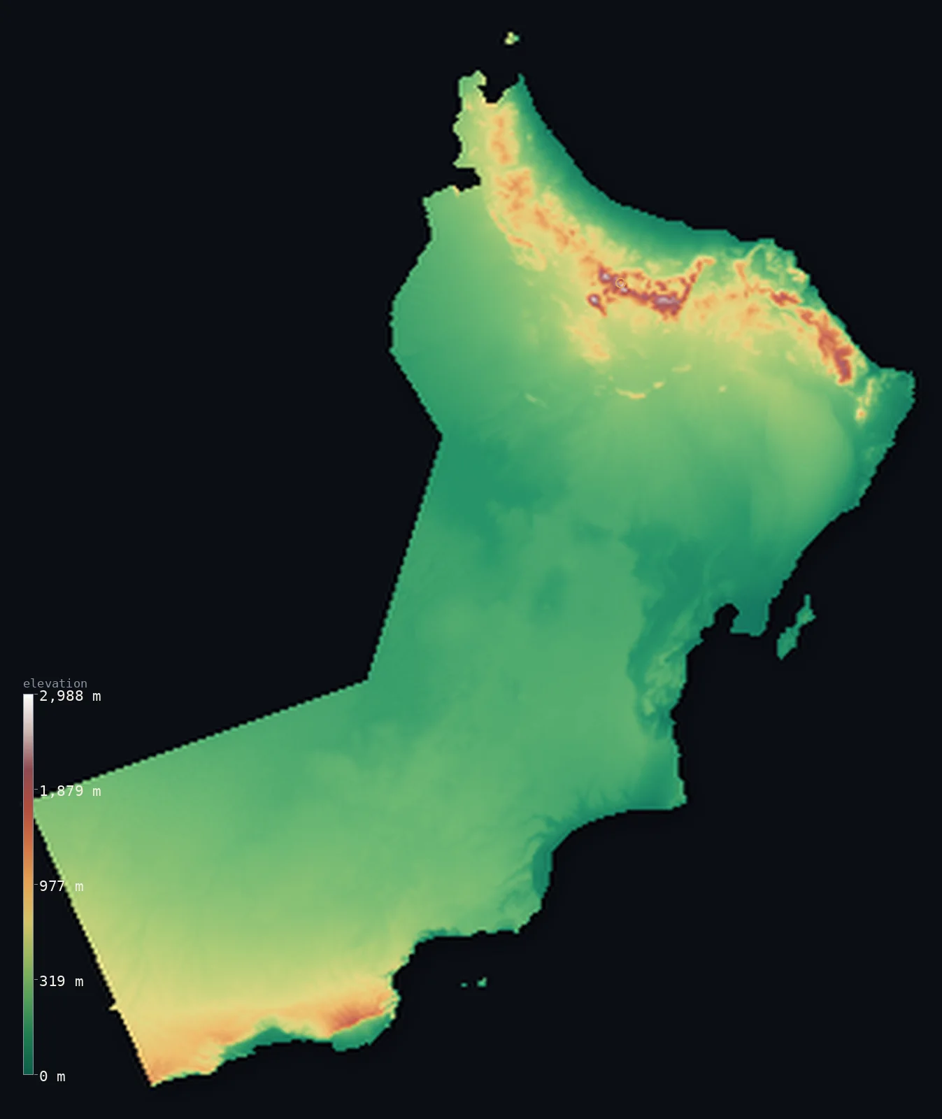
Oman’s highest point is Jabal Shams at 9,872 ft (3,009 m); its lowest is Arabian Sea at 0 ft (0 m); the mean elevation is 902 ft (275 m).
Oman is mostly low desert, its heights gathered at the edges. Beyond a narrow northern coast where most Omanis live, the interior is arid — gravel plains and the great sands of the Rub' al Khali, the Empty Quarter — so half the country lies below about 617 ft (188 m). But two corners rise high: the Al Hajar Mountains arc across the north, climbing to Jabal Shams at 9,872 ft (3,009 m), the highest point in eastern Arabia, beside the deep gorge of Wadi Nakhr; and in the far south the Dhofar hills rise behind Salalah, greened each summer by the monsoon. To the far north, across a strip of the UAE, the mountainous Musandam Peninsula guards the Strait of Hormuz.
- Highest point📚
- 9,872 ft3,009 m
- Oman's highest point is Jabal Shams ('Mountain of the Sun') at 9,872 ft (3,009 m), in the Al Jabal al Akhdar massif of the Al Hajar Mountains in the interior north — the highest point in eastern Arabia. Beside it plunges Wadi Nakhr, the 'Grand Canyon of Arabia'.
- Lowest point📚
- 0 ft0 m
- Oman's lowest point is sea level, along its long Arabian Sea and Gulf of Oman coasts. From the narrow Batinah coastal plain in the north, where most Omanis live, the land rises steeply into the Al Hajar Mountains.
- Mean elevation⚙
- 902 ft275 m
- Computed from the GLO-30 model, Oman's mean elevation is 902 ft (275 m) — but this is lifted by the Al Hajar Mountains; the typical point is far lower. Half of Oman lies below about 617 ft (188 m), in the vast interior desert. Only the Hajar in the north and the Dhofar hills in the far south rise high.
- Median elevation⚙
- 617 ft188 m
- Half of Oman lies below about 617 ft (188 m) — much lower than the mean, because most of the country is low desert: gravel plains and the great sands of the Rub' al Khali. The Al Hajar Mountains in the north (rising to Jabal Shams) and the Dhofar hills in the south are the high exceptions that lift the average.
- Elevation range📚
- 9,872 ft3,009 m
- From the sea to the summit of Jabal Shams at 3,009 m, Oman's terrain spans about 9,872 ft — from warm coastal plains up to the high, bare limestone of the Al Hajar, snow-dusted on the rare cold winter day.
- Above 1,000 m (3,281 ft)⚙
- 2%
- About 2% of Oman rises above 1,000 m (3,281 ft) — the Al Hajar Mountains in the north, rising to Jabal Shams, and the Dhofar hills in the far south. The vast interior desert lies far below.
- Official area📚
- 119,499 mi²309,500 km²
- Oman covers about 119,499 sq mi (309,500 sq km) — a large, arid country on the southeast corner of Arabia, of low desert interior, the mountain arc of the Al Hajar in the north, the monsoon-greened Dhofar hills in the south, and the detached Musandam Peninsula on the Strait of Hormuz.
- Forest cover📚
- 0%
- Effectively none of Oman is forested — the country is desert and bare mountain, though the Dhofar hills in the far south turn briefly green each summer under the khareef monsoon.
Highest and lowest points
Oman's highest point is Jabal Shams, 9,872 ft (3,009 m), the 'Mountain of the Sun', in the Al Jabal al Akhdar of the Al Hajar Mountains in the interior north — the highest point in the whole Arabian Peninsula east of Yemen. Beside its summit plunges Wadi Nakhr, a gorge so deep it is called the 'Grand Canyon of Arabia'. The high plateau catches enough rain for terraced orchards, and snow dusts the peak on the rare cold winter day. From this mountain arc the land falls away — steeply to the northern coast, and gradually into the vast desert interior that fills most of the country.
source ↗Oman's lowest ground is its coastline, at sea level along the Gulf of Oman and the Arabian Sea. Behind the populated Batinah coast in the north rises the Al Hajar range — a 700 km arc of rugged limestone whose core, the Al Jabal al Akhdar, climbs to Jabal Shams (3,009 m, the highest point) beside the deep Wadi Nakhr gorge. Beyond the mountains, most of Oman is low desert: gravel plains, the Wahiba Sands, and the great sand sea of the Rub' al Khali along the western borders. In the far south the Dhofar hills rise behind Salalah, greened each summer by the monsoon. In the far north, separated from the rest of Oman by the United Arab Emirates, the mountainous Musandam Peninsula guards the Strait of Hormuz — but, cut off from the main body of the country, it lies beyond the area shown on this map.
source ↗Oman at a glance
Jabal Shams (3,009 m) is the highest point in eastern Arabia, and beside it Wadi Nakhr cuts a gorge so deep it is called the 'Grand Canyon of Arabia'.
source ↗Oman's Musandam Peninsula is an exclave - cut off from the rest of the country by the United Arab Emirates - guarding the Strait of Hormuz.
source ↗The Dhofar hills around Salalah are watered by the Indian Ocean monsoon (khareef) and turn green every summer, unlike anywhere else in Arabia.
source ↗The Al Hajar Mountains expose the most complete ophiolite on Earth - a slice of ancient ocean floor thrust onto the land.
source ↗Snow occasionally falls on the highest reaches of Jabal Shams in winter, despite Oman's desert reputation.
source ↗Much of western Oman lies in the Rub al Khali, the largest continuous sand desert in the world.
source ↗
Elevation profile of Oman
The largest share of land, 53%, falls in the 0–200 m band, and 86% of the territory lies below 500 m (1,640 ft).
- below 500 m (1,640 ft)86%
- 500–1,000 m11%
- 1,000–2,000 m2%
- above 2,000 m (6,562 ft)<1%
Highest peaks of Oman
| Peak | Elevation | Range | Note |
|---|---|---|---|
| Jabal Shams↗ | 9,872 ft3,009 m | Al Hajar / Al Jabal al Akhdar (north) | Highest point of Oman and eastern Arabia, beside the deep Wadi Nakhr canyon. |
| Jabal Kawr↗ | 8,957 ft2,730 m | Western Al Hajar (north) | A massive limestone peak west of Jabal Shams in the Western Hajar. |
| Jabal Samhan↗ | 6,890 ft2,100 m | Dhofar Mountains (far south) | The highest of the Dhofar hills above Salalah, greened by the summer monsoon. |
| Jabal Harim↗ | 6,847 ft2,087 m | Musandam (northern exclave) | The highest peak of the Musandam Peninsula, overlooking the Strait of Hormuz. |
| Jabal Bani Jabir↗ | 6,562 ft2,000 m | Eastern Al Hajar (northeast) | A high plateau of the Eastern Hajar toward the coast at Sur. |
Oman: the Al Hajar Mountains, the desert interior, and Dhofar and Musandam
The Al Hajar Mountains — the north
A 700 km arc of rugged limestone runs across the north, parallel to the coast. Its core, the Al Jabal al Akhdar ('Green Mountain'), rises to Jabal Shams (3,009 m, the high point) beside the 1,000 m-deep Wadi Nakhr gorge, catching enough rain for terraced orchards, and drops steeply to the Batinah coast where most Omanis live.
The desert interior
Beyond the mountains, most of Oman is low desert — gravel plains, the dune fields of the Wahiba Sands, and, in the west, the great sand sea of the Rub' al Khali, the Empty Quarter, shared with Saudi Arabia, the UAE and Yemen. This vast arid zone is nearly waterless and thinly inhabited.
Dhofar and the Musandam exclave
In the far south the Dhofar hills rise behind Salalah, uniquely watered by the summer monsoon (khareef), turning green while the rest of Arabia bakes. In the far north, separated from the rest of Oman by the United Arab Emirates, the mountainous Musandam Peninsula juts into the Strait of Hormuz — but, cut off from the main body of the country, it lies beyond the area shown on this map.
How to read this map
Color shows elevation; the raised relief shows real terrain. On this map Oman reads as a low desert country walled at the north by mountains — the broad low tones of the interior desert (the Rub' al Khali and gravel plains) filling most of the frame, the high browns and whites of the Al Hajar arc along the northern coast (highest at Jabal Shams), and the Dhofar hills rising in the far south above Salalah.
The 3D relief is the actual GLO-30 elevation data, exaggerated vertically so the mountains and the low desert both show; the ×N relief slider controls how much. Tap anywhere to read that point's exact elevation. (Oman's Musandam exclave, on the Strait of Hormuz, lies beyond the area shown.)
City elevations in Oman
Oman's cities line the northern coast and dot the interior — Muscat, the capital, on the Gulf of Oman below the Al Hajar Mountains, with Sur on the northeast coast, Rustaq at the foot of the Western Hajar, and Salalah far to the south on the monsoon-greened Dhofar coast.
| City | Population | Elevation |
|---|---|---|
| Muscatcapitalthe capital, on the Gulf of Oman coast at the foot of the Al Hajar Mountains ↗ | 797,000 | 56 ft17 m |
| ‘Ibrī | 163,473 | 1,184 ft361 m |
| Şalālahin the far south, on the Dhofar coast below hills greened by the summer monsoon ↗ | 163,140 | 39 ft12 m |
| Şaḩam | 140,000 | 13 ft4 m |
| Rustaqin the interior north, at the foot of the Western Hajar ↗ | 120,000 | 1,119 ft341 m |
| Al Buraymī | 73,670 | 984 ft300 m |
| Suron the northeast coast, below the Eastern Hajar ↗ | 71,152 | 13 ft4 m |
| Ibrā’ | 25,265 | 1,424 ft434 m |
| Adam | 17,283 | 919 ft280 m |
| Madḩā’ | 4,306 | 200 ft61 m |
Elevation sampled at each city centre from the Copernicus GLO-30 model. Cities and population from GeoNames (CC-BY 4.0).
Oman in comparison
Oman's terrain rises 9,872 ft (3,009 m) from sea level to Jabal Shams — about 34% of the height of Mount Everest, the world's highest point at 29,032 ft (8,849 m).
- United Arab Emirates's mean elevation is 384 ft — 518 ft lower; its high point, Jebel Jais (UAE high point), reaches 6,207 ft (1,892 m), 3,665 ft below. United Arab Emirates elevation map →
- Saudi Arabia's mean elevation is 2,093 ft — 1,191 ft higher; its high point, Jabal Sawda, reaches 9,892 ft (3,015 m), 20 ft above. Saudi Arabia elevation map →
- Yemen's mean elevation is 3,081 ft — 2,178 ft higher; its high point, Jabal an-Nabi Shuayb, reaches 12,028 ft (3,666 m), 2,156 ft above. Yemen elevation map →
Frequently asked questions
What is the highest point in Oman?
- Jabal Shams, 9,872 ft (3,009 m), in the Al Hajar Mountains of the north - the highest point in eastern Arabia.
What is the average elevation of Oman?
- Computed from the Copernicus GLO-30 model, the area-weighted mean is 902 ft (275 m). Oman is mostly low desert with mountains in the north and south.
What is the lowest point in Oman?
- Sea level, along the Gulf of Oman and Arabian Sea coasts.
Why is part of Oman separated from the rest?
- The mountainous Musandam Peninsula in the far north is an Omani exclave, cut off from the main country by the United Arab Emirates, commanding the Strait of Hormuz.
Does it snow in Oman?
- Rarely - only on the highest peaks of the Al Hajar Mountains, such as Jabal Shams, in winter. Most of the country is hot desert.
Is this a topographic, relief, contour, or elevation map of Oman?
- They describe the same thing - terrain height. This page renders Oman's actual elevation surface in interactive 3D (a relief or topographic view) and reports the elevation statistics computed from it; a contour map shows the same data as lines of equal height.
About this map
The terrain is rendered from the Copernicus GLO-30 digital elevation model (ESA), masked to the OMN-ADM0 boundary from geoBoundaries (gbOpen). Elevation statistics are computed directly from the model; peak names and researched facts are sourced and cited. See the methodology for the full pipeline.
Our area-weighted mean, computed from the Copernicus GLO-30 model, is 902 ft (275 m); the figure commonly cited elsewhere is 1,017 ft (310 m) (CIA World Factbook). Oman is mostly low desert, with its heights gathered at the edges. Beyond the narrow northern coast, most of the country is arid interior — gravel plains and the great sands of the Rub' al Khali, the Empty Quarter, shared with Saudi Arabia, the UAE and Yemen. These low lands hold the bulk of Oman, so half of it lies below about 617 ft (188 m). The high ground is confined to two corners: the great arc of the Al Hajar Mountains across the north, rising to Jabal Shams (3,009 m, the highest in eastern Arabia), and the Dhofar hills in the far south, uniquely watered by the summer monsoon. These mountains lift the average well above the low, typical desert.
Surveyed national figures: official area · forest cover · high point.
Rendered from Copernicus GLO-30 (ESA, 2021 release), boundaries from geoBoundaries. Generated 2026-06-26.
Bordering countries · 3
Oman shares a land border with these countries — open any one to compare its terrain and highest point.