Yemen Elevation Map — Topographic & 3D Terrain
Explore the terrain of Yemen in interactive 3D, built from Copernicus GLO-30 satellite elevation data — the most mountainous country in Arabia, of high western highlands, low coastal plains and eastern desert. Drag to rotate, scroll to zoom, and tap any point to read its elevation.
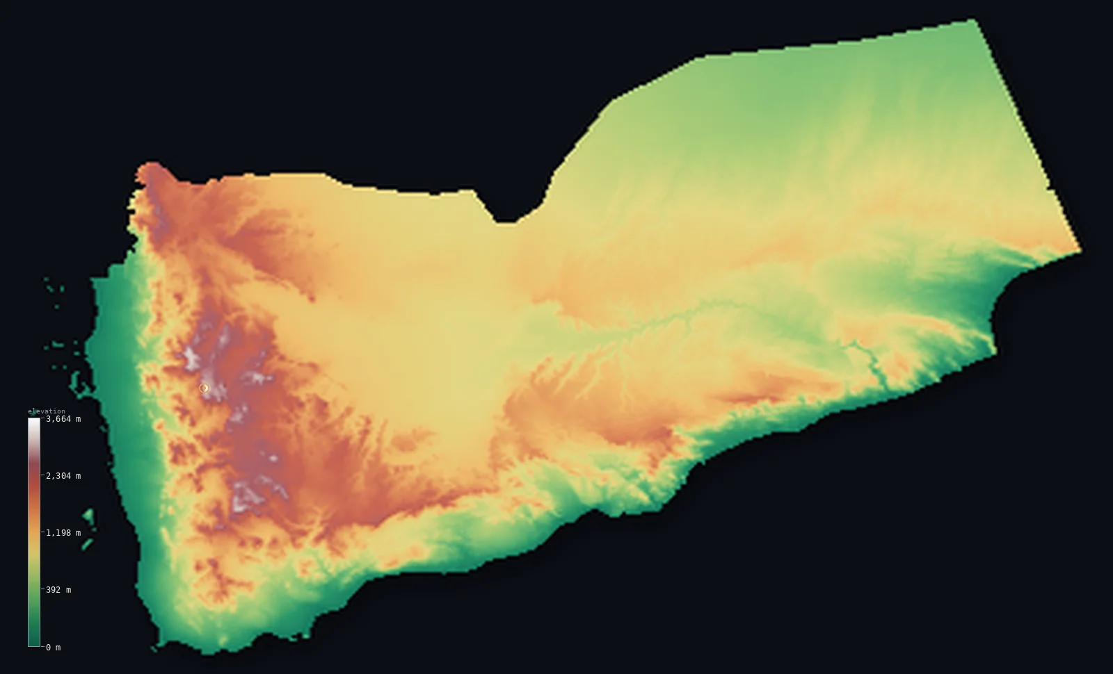
Yemen’s highest point is Jabal an-Nabi Shuayb at 12,028 ft (3,666 m); its lowest is Arabian Sea at 0 ft (0 m); the mean elevation is 3,081 ft (939 m).
Yemen is the high corner of the Arabian Peninsula — a country of rugged western highlands rising above hot coastal plains and eastern desert. From the Red Sea and the Gulf of Aden, the land climbs steeply into the Sarawat mountains, terraced and monsoon-fed, which hold Jabal an-Nabi Shuayb at 12,028 ft (3,666 m) — the highest peak in all of Arabia, just west of the high capital, Sanaa. Behind the western escarpment stretch drier central plateaus, and beyond them the land falls into the eastern deserts and the sands of the Rub' al Khali. So much of Yemen is highland that half the country lies above about 2,887 ft (880 m).
- Highest point📚
- 12,028 ft3,666 m
- Yemen's highest point is Jabal an-Nabi Shuayb at 12,028 ft (3,666 m), in the Sarawat mountains of the western highlands just west of the capital, Sanaa — and the highest peak of the entire Arabian Peninsula, rising above a plateau already some 1,500 m high.
- Lowest point📚
- 0 ft0 m
- Yemen's lowest point is sea level, along its long coasts — the Red Sea in the west, the Gulf of Aden in the south, and the Arabian Sea in the southeast. From the hot, low coastal plains the land climbs steeply into the highlands.
- Mean elevation⚙
- 3,081 ft939 m
- Computed from the GLO-30 model, Yemen's mean elevation is 3,081 ft (939 m) — a high figure, for Yemen is the most mountainous country in Arabia: the western Sarawat highlands rise well above 2,000 m, terraced and monsoon-fed. Half the country lies above about 2,887 ft (880 m); only the coastal plains and the eastern desert lie low.
- Median elevation⚙
- 2,887 ft880 m
- Half of Yemen lies above about 2,887 ft (880 m) — a high midpoint, because the western and central highlands cover much of the country and stand high. Only the hot Tihamah plain along the Red Sea and the eastern deserts merging into the Rub' al Khali lie near sea level.
- Elevation range📚
- 12,028 ft3,666 m
- From the sea to the summit of Jabal an-Nabi Shuayb at 3,666 m, Yemen's terrain spans about 12,028 ft — from hot coastal plains up to the highest mountain in all of Arabia, snow rare but frost common on the heights.
- Above 1,000 m (3,281 ft)⚙
- 37%
- About 37% of Yemen rises above 1,000 m (3,281 ft) — the western and central highlands, the terraced Sarawat mountains and the high plateau around Sanaa. The coastal plains and the eastern desert lie below.
- Above 2,000 m (6,562 ft)⚙
- 6%
- Roughly 6% of Yemen stands above 2,000 m (6,562 ft) — the high Sarawat peaks of the west, around Sanaa and rising to Jabal an-Nabi Shuayb, the highest point in Arabia.
- Official area📚
- 203,850 mi²527,968 km²
- Yemen covers about 203,850 sq mi (527,968 sq km) — a large country at the southwest corner of Arabia, of high western highlands, low coastal plains, and eastern deserts merging into the Rub' al Khali, plus the far-offshore Socotra archipelago.
- Forest cover📚
- 1%
- About 1% of Yemen is forested — the country is a land of terraced highlands, coastal plain and desert, almost bare of woodland, though the western mountains catch enough monsoon rain for intensive hillside farming.
Highest and lowest points
Yemen's highest point is Jabal an-Nabi Shuayb, 12,028 ft (3,666 m), in the Sarawat mountains of the western highlands, a short way west of the capital, Sanaa. It is the highest peak not only of Yemen but of the entire Arabian Peninsula, higher than any summit in Saudi Arabia or Oman. It rises from a plateau already about 1,500 m high, in a region of spectacular farmed terraces watered by the monsoon — the most fertile corner of Arabia. (An older figure of 3,760 m is sometimes quoted but is not supported by satellite elevation data.)
source ↗Yemen's lowest ground is its coastline — the Red Sea in the west, the Gulf of Aden in the south, and the Arabian Sea in the southeast, all at sea level. Behind the western coast, the hot, low Tihamah plain gives way abruptly to the Sarawat mountains, which climb to Jabal an-Nabi Shuayb (3,666 m), the highest point in Arabia, near Sanaa. Behind the western escarpment stretch the drier central highland plateaus, and beyond them the land falls into the eastern deserts and the great sands of the Rub' al Khali along the Saudi border. Far out in the Arabian Sea, some 350 km offshore, lies the Socotra archipelago, a world apart of endemic plants — so distant it falls beyond the main body of the country shown here.
source ↗Yemen at a glance
Jabal an-Nabi Shuayb is not only Yemen's highest point but the highest in the entire Arabian Peninsula.
source ↗Yemen's western mountains catch the monsoon, making them the most fertile and heavily terraced land in Arabia.
source ↗The remote island of Socotra, far offshore, is home to the dragon's blood tree and many other plants found nowhere else.
source ↗The capital, Sanaa, is one of the highest capital cities in the world, at about 2,300 m.
source ↗Yemen has no permanent rivers - only wadis that run after rain, like the great Wadi Hadramawt.
source ↗
Elevation profile of Yemen
The largest share of land, 26%, falls in the 750–1,000 m band, and 78% of the territory lies above 500 m (1,640 ft).
- below 500 m (1,640 ft)22%
- 500–1,000 m41%
- 1,000–2,000 m31%
- above 2,000 m (6,562 ft)6%
Highest peaks of Yemen
| Peak | Elevation | Range | Note |
|---|---|---|---|
| Jabal an-Nabi Shuayb↗ | 12,028 ft3,666 m | Sarawat (western highlands) | Highest point of Yemen and of the whole Arabian Peninsula, near Sanaa. |
| Haghier Mountains (Socotra)↗ | 4,931 ft1,503 m | Socotra (Hajhir) | The granite high point of Socotra island, far offshore in the Arabian Sea - home to unique dragon's blood trees. |
Yemen: the western highlands, the interior and desert, and the southern coast
The western highlands and Tihamah
Western Yemen is dominated by the Sarawat mountains — a high, dissected range that catches the monsoon, the most fertile corner of Arabia, farmed in spectacular hillside terraces. It rises to Jabal an-Nabi Shuayb (3,666 m), the highest point in the whole peninsula, near the lofty capital, Sanaa. Westward the mountains fall abruptly to the Tihamah, a hot coastal plain along the Red Sea.
The interior highlands and desert
Behind the western escarpment stretch drier central highland plateaus. Northward and eastward the land falls into upland desert plains that merge into the great sands of the Rub' al Khali, the Empty Quarter, along the Saudi border. In the southeast the deep Wadi Hadramawt cuts through arid sandstone country.
The southern coast and Socotra
The south faces the Gulf of Aden in a line of coastal plains, with the port of Aden in an old volcanic crater. Far out in the Arabian Sea, some 350 km offshore, lies Socotra, a world apart of endemic plants such as the dragon's blood tree — so distant it falls beyond the main body of the country shown here.
How to read this map
Color shows elevation; the raised relief shows real terrain. On this map Yemen reads as a high western spine falling to low edges — the browns and whites of the Sarawat highlands standing along the west (highest at Jabal an-Nabi Shuayb, the roof of Arabia), dropping sharply to the low green Tihamah plain along the Red Sea, and falling eastward into the desert that merges into the Rub' al Khali.
The 3D relief is the actual GLO-30 elevation data, exaggerated vertically so the highlands and the low coast and desert both show; the ×N relief slider controls how much. Tap anywhere to read that point's exact elevation. (The far-offshore island of Socotra lies beyond the area shown.)
City elevations in Yemen
Yemen's cities divide between the high western mountains and the coast — Sanaa, the capital, stands high in the Sarawat below the country's greatest peaks, with Taiz and Dhamar in the highlands, while Aden and Mukalla lie on the southern coast and Al Hudaydah on the Red Sea plain. Much of the population lives high, in the mountains.
| City | Population | Elevation |
|---|---|---|
| Sanaacapitalthe capital, high in the western Sarawat mountains at about 2,300 m, below Jabal an-Nabi Shuayb ↗ | 1,937,451 | 7,388 ft2,252 m |
| Adenon the southern coast, on the Gulf of Aden, set in an old volcanic crater ↗ | 1,079,670 | 49 ft15 m |
| Taizin the southern highlands, below Jabal Sabir ↗ | 940,600 | 4,311 ft1,314 m |
| Al Ḩudaydah | 734,699 | 33 ft10 m |
| Mukallaa port on the Arabian Sea coast of the Hadramawt in the southeast ↗ | 594,951 | 72 ft22 m |
| Dhamār | 160,114 | 7,943 ft2,421 m |
| Sa'dah | 51,870 | 6,138 ft1,871 m |
| Al Bayda | 37,821 | 6,539 ft1,993 m |
| Ataq | 37,315 | 3,747 ft1,142 m |
| Al Ḩazm | 18,241 | 3,629 ft1,106 m |
Elevation sampled at each city centre from the Copernicus GLO-30 model. Cities and population from GeoNames (CC-BY 4.0).
Yemen in comparison
Yemen's terrain rises 12,028 ft (3,666 m) from sea level to Jabal an-Nabi Shuayb — about 41% of the height of Mount Everest, the world's highest point at 29,032 ft (8,849 m).
- Oman's mean elevation is 902 ft — 2,178 ft lower; its high point, Jabal Shams, reaches 9,872 ft (3,009 m), 2,156 ft below. Oman elevation map →
- Saudi Arabia's mean elevation is 2,093 ft — 988 ft lower; its high point, Jabal Sawda, reaches 9,892 ft (3,015 m), 2,136 ft below. Saudi Arabia elevation map →
- Eritrea's mean elevation is 2,507 ft — 574 ft lower; its high point, Emba Soira, reaches 9,902 ft (3,018 m), 2,126 ft below. Eritrea elevation map →
Frequently asked questions
What is the highest point in Yemen?
- Jabal an-Nabi Shuayb, 12,028 ft (3,666 m), in the western highlands near Sanaa - also the highest point in the whole Arabian Peninsula.
What is the average elevation of Yemen?
- Computed from the Copernicus GLO-30 model, the area-weighted mean is 3,081 ft (939 m) - high, because much of the country is mountainous highland.
What is the lowest point in Yemen?
- Sea level, on the Red Sea, the Gulf of Aden and the Arabian Sea.
Is Jabal an-Nabi Shuayb the highest mountain in Arabia?
- Yes - at 3,666 m it is the highest point not just in Yemen but in the entire Arabian Peninsula.
Does this map show Socotra?
- Socotra lies about 350 km offshore in the Arabian Sea, so it sits far outside the main body of the country and may fall beyond the area rendered here, though it is part of Yemen.
Is this a topographic, relief, contour, or elevation map of Yemen?
- They describe the same thing - terrain height. This page renders Yemen's actual elevation surface in interactive 3D (a relief or topographic view) and reports the elevation statistics computed from it; a contour map shows the same data as lines of equal height.
About this map
The terrain is rendered from the Copernicus GLO-30 digital elevation model (ESA), masked to the YEM-ADM0 boundary from geoBoundaries (gbOpen). Elevation statistics are computed directly from the model; peak names and researched facts are sourced and cited. See the methodology for the full pipeline.
Our area-weighted mean, computed from the Copernicus GLO-30 model, is 3,081 ft (939 m); the figure commonly cited elsewhere is 3,278 ft (999 m) (CIA World Factbook). Yemen is the high corner of Arabia. Its western Sarawat mountains catch the monsoon and rise, terraced and farmed, to Jabal an-Nabi Shuayb — at 3,666 m the highest peak in the whole Arabian Peninsula — near the lofty capital, Sanaa, itself about 2,300 m high. So much of the country is highland that half of Yemen lies above about 2,887 ft (880 m). Only the hot Tihamah plain along the Red Sea, the southern coast at Aden, and the eastern deserts merging into the Rub' al Khali lie low. It is a country defined by its height.
Surveyed national figures: official area · forest cover · high point.
Rendered from Copernicus GLO-30 (ESA, 2021 release), boundaries from geoBoundaries. Generated 2026-07-08.
Bordering countries · 2
Yemen shares a land border with these countries — open any one to compare its terrain and highest point.