Bangladesh Elevation Map — Topographic & 3D Terrain
Explore the terrain of Bangladesh in interactive 3D, built from Copernicus GLO-30 satellite elevation data — one of the largest river deltas on Earth, flat and barely above the sea. Drag to rotate, scroll to zoom, and tap any point to read its elevation.
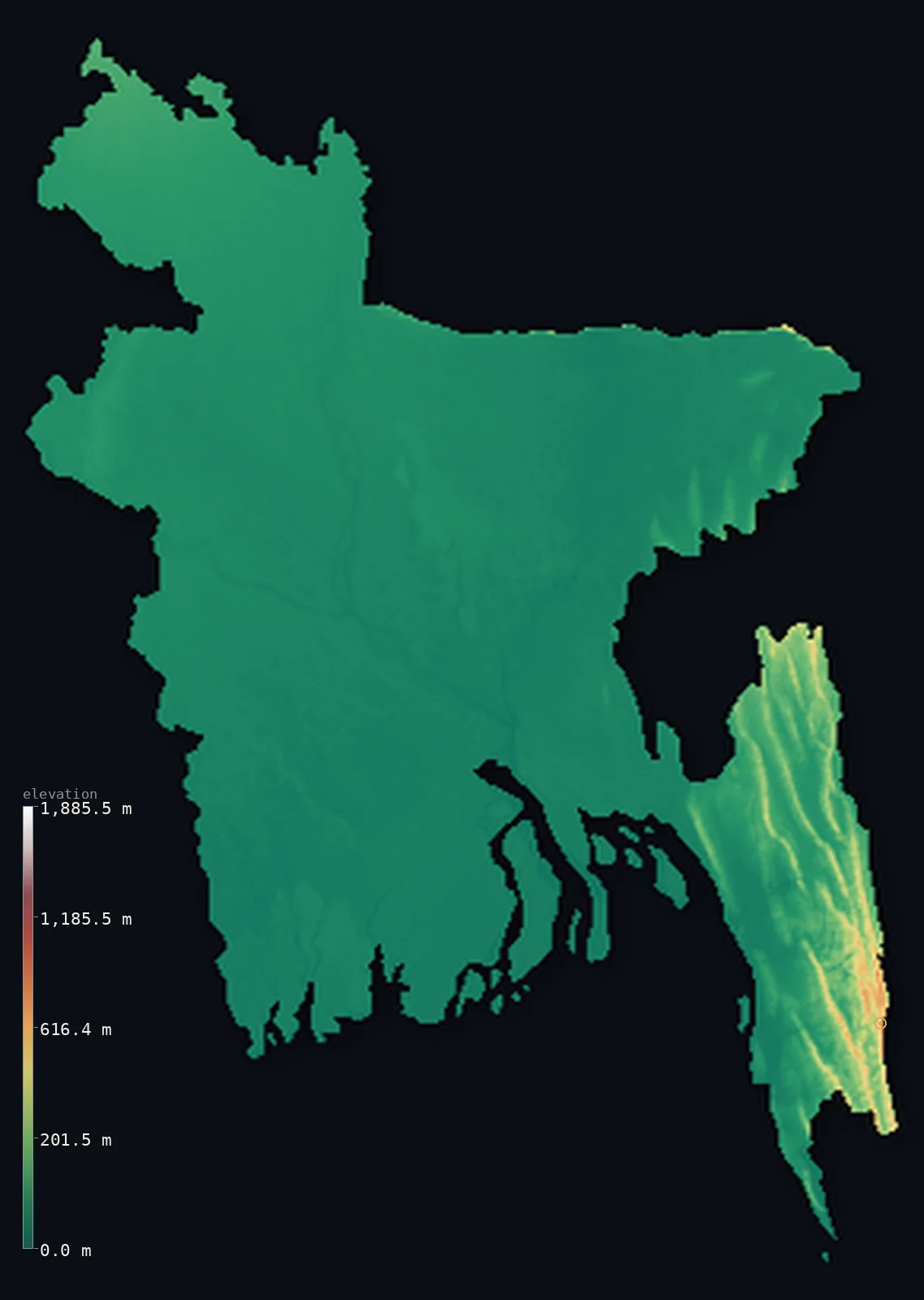
Bangladesh’s highest point is Saka Haphong (Mowdok Mual) at 3,451 ft (1,052 m); its lowest is Bay of Bengal at 0 ft (0 m); the mean elevation is 90 ft (27.4 m).
Bangladesh is a delta. Almost the entire country is the low, flat floodplain where the Ganges, the Brahmaputra, and the Meghna converge and spread toward the Bay of Bengal — one of the largest and most fertile deltas on Earth, and one of the lowest-lying countries anywhere. Its mean elevation is just 90 ft (27 m), and about 90% of it lies below 164 ft (50 m). The only real high ground is in the far southeast, in the Chittagong Hill Tracts, where the land finally rises to Saka Haphong at 3,451 ft (1,052 m).
- Highest point📚
- 3,451 ft1,052 m
- Bangladesh's highest point is Saka Haphong at 3,451 ft (1,052 m), in the Chittagong Hill Tracts of the far southeast — a modest summit in the country's one hilly corner, where the ridges of the Indo-Burman ranges cross the border from Myanmar. It is the sole exception to an overwhelmingly flat country.
- Lowest point📚
- 0 ft0 m
- Bangladesh's lowest point is the Bay of Bengal at sea level, along the southern coast — the seaward edge of the great delta, a shifting shore of tidal flats, river mouths, and the mangrove forest of the Sundarbans.
- Mean elevation⚙
- 90 ft27.4 m
- Computed from the GLO-30 model, Bangladesh's mean elevation is just 90 ft (27.4 m) — one of the lowest of any country on Earth, and a faithful measure of a nation that is almost entirely river delta, floodplain, and coastal lowland, barely raised above the sea.
- Median elevation⚙
- 35 ft10.7 m
- Half of Bangladesh lies below 35 ft (11 m) — an extraordinarily low median, the mark of a country that is nearly all delta: an immense flat expanse of alluvial plain, criss-crossed by rivers and rarely rising more than a few metres above them.
- Elevation range📚
- 3,451 ft1,052 m
- From the Bay of Bengal to the summit of Saka Haphong, Bangladesh spans only about 3,450 ft — a small range for a whole country, and almost all of it confined to the hilly southeastern corner; across the vast delta, the land barely changes height at all.
- Above 50 m (164 ft)⚙
- 11%
- About 11% of Bangladesh rises above 164 ft (50 m) — and barely: the country is almost entirely low delta and floodplain, with only the ridges of the Chittagong Hill Tracts in the far southeast climbing higher, above 1,000 m.
- Official area📚
- 57,321 mi²148,460 km²
- Bangladesh covers about 57,300 sq mi (148,460 sq km) — a densely populated country built almost entirely on the delta of the Ganges, Brahmaputra, and Meghna, at the head of the Bay of Bengal.
- Forest cover📚
- 11.1%
- About 11.1% of Bangladesh is forested — most notably the Sundarbans, the largest mangrove forest in the world, along the southern coast, with hill forest in the Chittagong tract; the rest is among the most intensively farmed land on Earth.
Highest and lowest points
Bangladesh's highest point is Saka Haphong, 3,451 ft (1,052 m), in the Chittagong Hill Tracts of the far southeast — the one genuinely hilly corner of an otherwise flat country. Here the ground rises into the forested ridges of the Indo-Burman ranges, which continue east into Myanmar and India; the hills are steep, remote, and culturally distinct from the delta lowlands that make up the rest of Bangladesh. Only recently confirmed by GPS survey as the country's true high point, Saka Haphong overtook the long-cited Keokradong nearby.
source ↗Bangladesh's lowest point is the Bay of Bengal at sea level, along a southern coast that is the seaward front of the delta — a low, shifting edge of tidal flats, river mouths, sandbars, and the vast mangrove forest of the Sundarbans. The land here is barely above the tide, and much of the coastal delta floods with the monsoon and the storm surges of Bay of Bengal cyclones. In a country this low, the line between land and sea is never fixed.
source ↗Bangladesh at a glance
Bangladesh is one of the lowest-lying countries on Earth — about 90% of it sits below 50 m, on the delta of the Ganges, Brahmaputra, and Meghna.
source ↗The Ganges-Brahmaputra-Meghna delta is one of the largest river deltas in the world, and among the most fertile and densely populated.
source ↗The Sundarbans, along Bangladesh's southern coast, is the largest mangrove forest in the world and a refuge of the Bengal tiger.
source ↗Bangladesh's highest point, Saka Haphong (1,052 m), lies in the hilly southeastern corner and was only recently confirmed by GPS to surpass the long-cited Keokradong.
source ↗Much of Bangladesh floods each monsoon season, as the great rivers rise and spread across the flat delta — the floods renew the soil that makes the land so fertile.
source ↗The country is crossed by hundreds of rivers, and the shifting courses of the Ganges and Brahmaputra constantly reshape the low delta landscape.
source ↗The Ganges and Brahmaputra deliver close to a billion tonnes of sediment a year, building the Bengal Delta and a submarine fan up to 16.5 km thick — the largest sediment pile on the planet.
source ↗
Elevation profile of Bangladesh
The largest share of land, 95%, falls in the 0–100 m band, and >99% of the territory lies below 500 m (1,640 ft).
- 0–10 m (0–33 ft)47%
- 10–50 m (33–164 ft)42%
- above 50 m (164 ft)11%
Highest peaks of Bangladesh
| Peak | Elevation | Range | Note |
|---|---|---|---|
| Saka Haphong (Mowdok Mual)↗ | 3,451 ft1,052 m | Mowdok Range (Chittagong Hill Tracts) | Highest point of Bangladesh, on the Myanmar border; confirmed as the true summit only in the mid-2000s. |
| Zow Tlang (Reang Haphong)↗ | 3,291 ft1,003 m | Mowdok Range | A neighbouring high peak of the Mowdok range in the far southeast. |
| Dumlong↗ | 3,232 ft985 m | Reng Tlang range (Chittagong Hill Tracts) | A high peak of the Reng Tlang range in the far southeast, among the tallest in the Chittagong Hill Tracts. |
| Keokradong↗ | 2,897 ft883 m | Chittagong Hill Tracts | Long popularly believed to be the country's highest peak; a well-known trekking summit, but lower than Saka Haphong. |
| Tazing Dong (Bijoy)↗ | 2,717 ft828 m | Chittagong Hill Tracts | Officially recognised by the Bangladesh government as the highest peak, though actually lower than Saka Haphong. |
The delta, the coast, and the southeastern hills
The Ganges-Brahmaputra-Meghna delta
The overwhelming fact of Bangladesh — the vast, flat, low floodplain where three great rivers converge and spread toward the sea. Alluvial, fertile, and criss-crossed by countless channels, it covers almost the whole country and holds one of the densest rural populations on Earth. This is why Bangladesh is so low and so flat.
The coast and the Sundarbans
Along the south, the delta meets the Bay of Bengal in a shifting front of tidal flats, river mouths, and sandbars, fringed by the Sundarbans — the largest mangrove forest in the world. Low, waterlogged, and exposed to cyclones and storm surge, it is the country's seaward edge.
The Chittagong Hill Tracts (southeast)
In the far southeast, along the borders with Myanmar and India, the flat delta gives way to hills — the forested ridges of the Indo-Burman ranges, rising to Saka Haphong, the country's high point. Steep and remote, it is the one part of Bangladesh that is not delta lowland.
How to read this map
Color shows elevation; the raised relief shows real terrain. On this map Bangladesh reads almost entirely in the lowest greens — a vast flat delta laced with the pale threads of its rivers, barely raised above the sea — with a single patch of raised brown in the far southeastern corner, the Chittagong Hill Tracts.
The 3D relief is the actual GLO-30 elevation data, exaggerated vertically far more than usual so that a country this flat shows any shape at all; the ×N relief slider controls how much. Tap anywhere to read that point's exact elevation.
City elevations in Bangladesh
Bangladesh's cities sit on the delta — Dhaka near the centre on the Buriganga, Chattogram on the southeastern coast, the others across the floodplain. Nearly all stand just a few metres above the rivers and the sea.
| City | Population | Elevation |
|---|---|---|
| Dhakacapitalthe capital, on the Buriganga river near the centre of the delta, one of the most densely populated cities in the world ↗ | 10,356,500 | 62 ft19 m |
| Chattogramthe main seaport, on the southeastern coast near the Hill Tracts ↗ | 3,920,222 | 56 ft17 m |
| Khulna | 1,500,689 | 26 ft8 m |
| Rangpur | 1,031,388 | 121 ft37 m |
| Comilla | 1,030,000 | 46 ft14 m |
| Rajshahi | 763,580 | 72 ft22 m |
| Mohammadpur | 527,571 | 125 ft38 m |
| Shibganj | 378,701 | 79 ft24 m |
| Nagar Naluākot | 273,000 | 49 ft15 m |
| Cox’s Bāzār | 253,788 | 7 ft2 m |
Elevation sampled at each city centre from the Copernicus GLO-30 model. Cities and population from GeoNames (CC-BY 4.0).
Bangladesh in comparison
Bangladesh's terrain rises 3,451 ft (1,052 m) from sea level to Saka Haphong (Mowdok Mual) — about 12% of the height of Mount Everest, the world's highest point at 29,032 ft (8,849 m).
- Nepal's mean elevation is 6,929 ft — 6,839 ft higher; its high point, Mount Everest (Sagarmatha), reaches 29,032 ft (8,849 m), 25,581 ft above. Nepal elevation map →
- Bhutan's mean elevation is 9,354 ft — 9,264 ft higher; its high point, Gangkhar Puensum, reaches 24,836 ft (7,570 m), 21,385 ft above. Bhutan elevation map →
- Netherlands's mean elevation is 30 ft — 60 ft lower; its high point, Vaalserberg, reaches 1,056 ft (322 m), 2,395 ft below. Netherlands elevation map →
Frequently asked questions
What is the highest point in Bangladesh?
- Saka Haphong, 3,451 ft (1,052 m), in the Chittagong Hill Tracts of the far southeast — the country's one hilly corner, recently confirmed by GPS to surpass the long-cited Keokradong.
What is the lowest point in Bangladesh?
- The Bay of Bengal at sea level, along the southern coast, the seaward edge of the great delta.
What is the average elevation of Bangladesh?
- Computed from the Copernicus GLO-30 model, the area-weighted mean is 90 ft (27.4 m) — one of the lowest of any country, because Bangladesh is almost entirely river delta and floodplain.
Is Bangladesh flat?
- Overwhelmingly — about 90% lies below 50 m, and the median elevation is only about 11 m. It is almost entirely delta, with hills only in the far southeastern corner.
What is the Sundarbans?
- The largest mangrove forest in the world, along Bangladesh's southern coast at the edge of the delta — a tidal forest of channels and islands, and a refuge of the Bengal tiger.
Is this a topographic, relief, contour, or elevation map of Bangladesh?
- They describe the same thing — terrain height. This page renders the country's actual elevation surface in interactive 3D and reports the statistics computed from it.
About this map
The terrain is rendered from the Copernicus GLO-30 digital elevation model (ESA), masked to the BGD-ADM0 boundary from geoBoundaries (gbOpen). Elevation statistics are computed directly from the model; peak names and researched facts are sourced and cited. See the methodology for the full pipeline.
Our area-weighted mean, computed from the Copernicus GLO-30 model, is 90 ft (27.4 m); the figure commonly cited elsewhere is 279 ft (85 m) (CIA World Factbook). Roughly 79% of Bangladesh is low deltaic plain — most of the country lies under about 10 m and little of it above 90 m — so the mean elevation is very low; the page reports the area-weighted figure computed from the Copernicus GLO-30 model.
Surveyed national figures: official area · forest cover · high point.
Rendered from Copernicus GLO-30 (ESA, 2021 release), boundaries from geoBoundaries. Generated 2026-07-09.
Bordering countries · 2
Bangladesh shares a land border with these countries — open any one to compare its terrain and highest point.