South Korea Elevation Map — Topographic & 3D Terrain
Explore the terrain of South Korea in interactive 3D, built from Copernicus GLO-30 satellite elevation data — a peninsula tilted high along its eastern edge and sloping west to the sea. Drag to rotate, scroll to zoom, and tap any point to read its elevation.
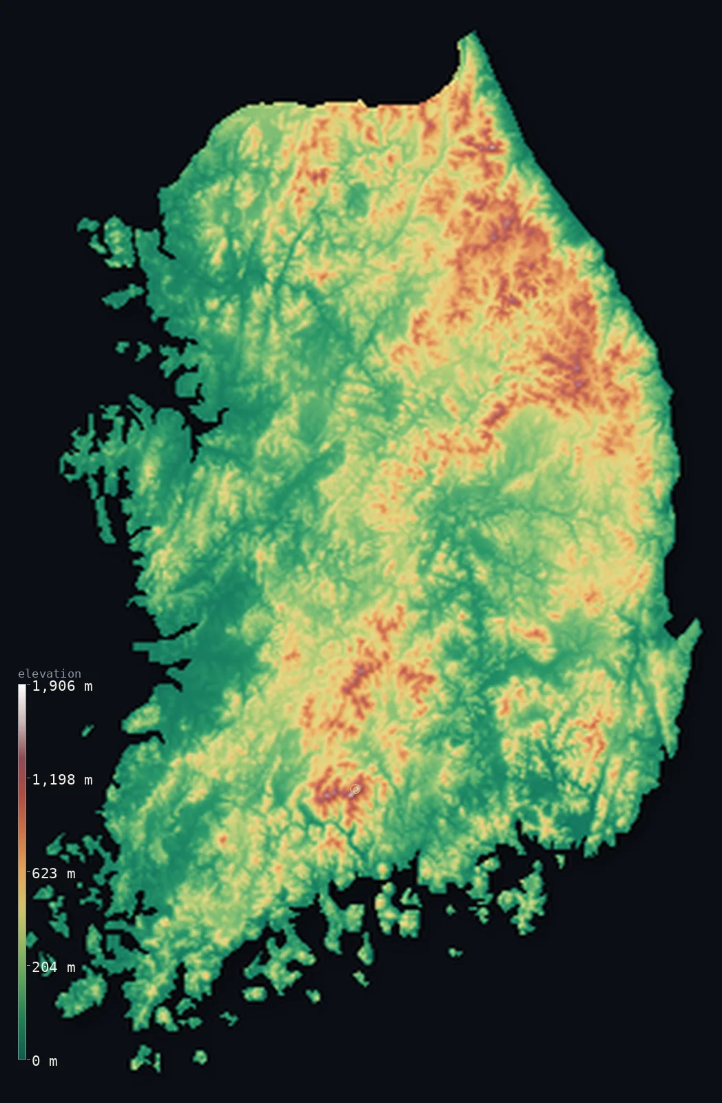
South Korea’s highest point is Jirisan (Cheonwangbong) at 6,283 ft (1,915 m); its lowest is Sea of Japan at 0 ft (0 m); the mean elevation is 860 ft (262 m).
South Korea is tilted. The Taebaek mountains run close along the eastern coast, so the land drops steeply to the East Sea on one side and slopes gradually westward on the other — which is why every major river in the country flows west, and why almost everyone lives on the western plains. It is mountainous but not high: about 70% of the land is hill or mountain, yet only 1.4% of it clears 3,281 ft (1,000 m), and half the country lies below 620 ft (189 m).
- Highest point📚
- 6,283 ft1,915 m
- The highest point on the South Korean mainland is Jirisan — its Cheonwangbong peak — at 6,283 ft (1,915 m), in the Sobaek range of the south. The country's true high point is slightly higher and lies offshore: Hallasan, at 6,388 ft (1,947 m), on Jeju Island, outside this mainland map.
- Lowest point📚
- 0 ft0 m
- South Korea's lowest point is the sea, on three coasts — the East Sea, the shallow island-strewn South Sea, and the Yellow Sea to the west, where tidal flats can extend for kilometres at low water.
- Mean elevation⚙
- 860 ft262 m
- South Korea's mean elevation computed from the GLO-30 model is 860 ft (262 m) — low, and a better description of the country than its reputation suggests: the mountains are pervasive but modest, more steep hill country than genuine high range.
- Median elevation⚙
- 620 ft189 m
- Half of South Korea lies below 620 ft (189 m) — the western plains and river valleys where Seoul and most of the population sit, on the gentle side of the country's tilt.
- Elevation range📚
- 6,283 ft1,915 m
- From the sea to Jirisan's summit, the mainland spans about 6,280 ft — a narrow range for a country this mountainous, because the ridges rise and fall repeatedly rather than building to any great height.
- Above 1,000 m (3,281 ft)⚙
- 1%
- Only about 1% of South Korea rises above 1,000 m (3,281 ft) — the crests of the Taebaek range along the east and the Sobaek range in the south. Nearly half the country, though, sits above 656 ft (200 m): hilly almost everywhere, high almost nowhere.
- Official area📚
- 38,502 mi²99,720 km²
- South Korea covers about 38,500 sq mi (99,720 sq km) — the southern half of a peninsula, with a coastline complicated in the south and west by thousands of islands and one of the largest tidal ranges in the world.
- Forest cover📚
- 63.5%
- About 64% of South Korea is forested — an unusually high share for a country this densely populated, because the steep hill country that covers most of the land was never worth clearing, and a national reforestation effort replanted much of what had been stripped.
Highest and lowest points
The highest point on the South Korean mainland is Jirisan, whose Cheonwangbong summit reaches 6,283 ft (1,915 m) in the Sobaek range — a broad, forested massif at the heart of the country's oldest national park. The highest point in all of South Korea is slightly higher: Hallasan, 6,388 ft (1,947 m), a shield volcano forming the whole of Jeju Island about 85 km off the south coast. Jeju lies outside this mainland map, so the summit shown here is Jirisan's — the two are separated by only about 32 m of height.
source ↗South Korea's lowest point is sea level, but its three coasts could hardly be more different. The eastern shore is straight and deep, with the mountains dropping almost directly into the East Sea. The southern coast is a drowned landscape of bays and thousands of small islands. And the western coast on the Yellow Sea has one of the largest tidal ranges on Earth — the water withdraws to expose vast mudflats, then returns across them.
source ↗South Korea at a glance
South Korea's true high point, Hallasan (1,947 m), is a volcano on Jeju Island - only about 32 m higher than Jirisan, the tallest mountain on the mainland.
source ↗About 70% of South Korea is mountain or hill country, yet only around 1.4% of it rises above 1,000 m - the ranges are everywhere but low.
source ↗The Taebaek mountains run close along the east coast, tilting the whole peninsula westward - which is why every major Korean river flows west.
source ↗The Yellow Sea coast has one of the largest tidal ranges in the world, exposing vast mudflats at low water.
source ↗Jeju Island is a single shield volcano rising from the sea, with a crater lake at the summit of Hallasan.
source ↗South Korea reforested much of its hill country in the second half of the twentieth century, after decades of wartime and colonial-era stripping left the slopes bare.
source ↗
Elevation profile of South Korea
The largest share of land, 52%, falls in the 0–200 m band, and 84% of the territory lies below 500 m (1,640 ft).
- below 500 m (1,640 ft)84%
- 500–1,000 m15%
- 1,000–2,000 m1%
Highest peaks of South Korea
| Peak | Elevation | Range | Note |
|---|---|---|---|
| Hallasan↗ | 6,388 ft1,947 m | Jeju Island | Highest point of South Korea, a shield volcano forming most of Jeju Island. |
| Jirisan (Cheonwangbong)↗ | 6,283 ft1,915 m | Sobaek Mountains | The highest mountain on the Korean mainland, at the southern end of the Sobaek range. |
| Seoraksan↗ | 5,604 ft1,708 m | Taebaek Mountains | A famous peak of the Taebaek range in the northeast, near the east coast. |
| Deogyusan↗ | 5,295 ft1,614 m | Sobaek Mountains | A high peak of the Sobaek range in the south-central interior. |
| Taebaeksan↗ | 5,141 ft1,567 m | Taebaek Mountains | A sacred peak of the eastern Taebaek range, the 'spine' of the peninsula. |
A peninsula tilted west
The Taebaek range and the east coast
The Taebaek mountains run north to south close along the eastern seaboard, forming the spine that tilts the peninsula. On their eastern side the land falls sharply to a straight, deep coast with barely any plain between mountain and sea.
The Sobaek range and the south
Branching southwest off the Taebaek, the Sobaek mountains cut diagonally across the interior and carry Jirisan, the mainland's highest peak. They separate the southeastern basin around Busan from the western plains.
The western plains and river valleys
West of the mountains the land slopes gently to the Yellow Sea in a patchwork of low hills, broad river valleys, and reclaimed coastal flats. The Han, Geum, and Nakdong rivers built this ground, and Seoul and most of the country's population live on it.
The southern coast and islands
The south dissolves into a drowned coastline of deep bays and thousands of islands, where old valleys were flooded as sea levels rose. Offshore to the south lies Jeju, a volcanic island that holds the country's true high point but sits outside this map.
How to read this map
Color shows elevation; the raised relief shows real terrain. On this map South Korea reads as a country leaning westward — browns crowding the eastern edge where the Taebaek range runs, fading through hill country to the green western plains and the island-scattered southern coast.
The 3D relief is the actual GLO-30 elevation data, exaggerated vertically so the eastern tilt and the low western ground both show; the ×N relief slider controls how much. Tap anywhere to read that point's exact elevation.
City elevations in South Korea
South Korea's cities sit on the low western side of the tilt - Seoul on the Han river plain, Incheon on the Yellow Sea coast - while Busan occupies a pocket of flat ground in the mountainous southeast. None of them is high; the country's population lives almost entirely below the hills.
| City | Population | Elevation |
|---|---|---|
| Seoulcapitalthe capital, on the Han river plain in the low northwest, ringed by hills ↗ | 10,349,312 | 115 ft35 m |
| Busanin a pocket of flat ground on the mountainous southeastern coast ↗ | 3,285,147 | 49 ft15 m |
| Daegu | 2,365,523 | 151 ft46 m |
| Daejeon | 1,441,203 | 194 ft59 m |
| Gwangju | 1,401,235 | 151 ft46 m |
| Ulsan | 1,098,421 | 36 ft11 m |
| Cheonan | 658,831 | 138 ft42 m |
| Hwaseong-si | 640,890 | 59 ft18 m |
| Jeonju | 638,421 | 141 ft43 m |
| Pohang | 492,041 | 16 ft5 m |
Elevation sampled at each city centre from the Copernicus GLO-30 model. Cities and population from GeoNames (CC-BY 4.0).
South Korea in comparison
South Korea's terrain rises 6,283 ft (1,915 m) from sea level to Jirisan (Cheonwangbong) — about 22% of the height of Mount Everest, the world's highest point at 29,032 ft (8,849 m).
- North Korea's mean elevation is 1,926 ft — 1,066 ft higher; its high point, Paektu (Janggun Peak), reaches 9,003 ft (2,744 m), 2,720 ft above. North Korea elevation map →
- Japan's mean elevation is 1,299 ft — 440 ft higher; its high point, Mount Fuji (Fujisan), reaches 12,388 ft (3,776 m), 6,106 ft above. Japan elevation map →
- Taiwan's mean elevation is 2,523 ft — 1,663 ft higher; its high point, Yushan (Jade Mountain), reaches 12,966 ft (3,952 m), 6,683 ft above. Taiwan elevation map →
Frequently asked questions
What is the highest point in South Korea?
- Hallasan, 6,388 ft (1,947 m), a volcano on Jeju Island. On the mainland - the area this map shows - the highest point is Jirisan's Cheonwangbong peak at 6,283 ft (1,915 m), only about 32 m lower.
What is the lowest point in South Korea?
- Sea level, on three coasts - the deep East Sea, the island-strewn South Sea, and the Yellow Sea with its vast tidal flats.
What is the average elevation of South Korea?
- Computed from the Copernicus GLO-30 model, the area-weighted mean is 860 ft (262 m) - low, because the country's many mountains are modest in height and the western plains are extensive.
How mountainous is South Korea?
- About 70% of the land is mountain or hill - but only around 1.4% rises above 1,000 m. It is hilly nearly everywhere and high almost nowhere.
Why do all of South Korea's rivers flow west?
- Because the Taebaek mountains run close along the east coast, tilting the whole peninsula westward - so the drainage, the plains, and most of the population are all on the western side.
Is this a topographic, relief, contour, or elevation map of South Korea?
- They describe the same thing - terrain height. This page renders the country's actual elevation surface in interactive 3D and reports the statistics computed from it.
About this map
The terrain is rendered from the Copernicus GLO-30 digital elevation model (ESA), masked to the KOR-ADM0 boundary from geoBoundaries (gbOpen). Elevation statistics are computed directly from the model; peak names and researched facts are sourced and cited. See the methodology for the full pipeline.
Our area-weighted mean, computed from the Copernicus GLO-30 model, is 860 ft (262 m); the figure commonly cited elsewhere is 925 ft (282 m) (CIA World Factbook). South Korea is hilly and mountainous - mountains cover most of the land, but they are moderate in height and the population crowds the western and southern lowlands - so the mean elevation is fairly low; the page reports the area-weighted figure computed from the Copernicus GLO-30 model.
Surveyed national figures: official area · forest cover · high point.
Rendered from Copernicus GLO-30 (ESA, 2021 release), boundaries from geoBoundaries. Generated 2026-07-07.
Bordering countries · 1
South Korea shares a land border with these countries — open any one to compare its terrain and highest point.