Taiwan Elevation Map — Topographic & 3D Terrain
Explore the terrain of Taiwan in interactive 3D, built from Copernicus GLO-30 satellite elevation data — a steep, mountainous island where high peaks rise close to the sea. Drag to rotate, scroll to zoom, and tap any point to read its elevation.
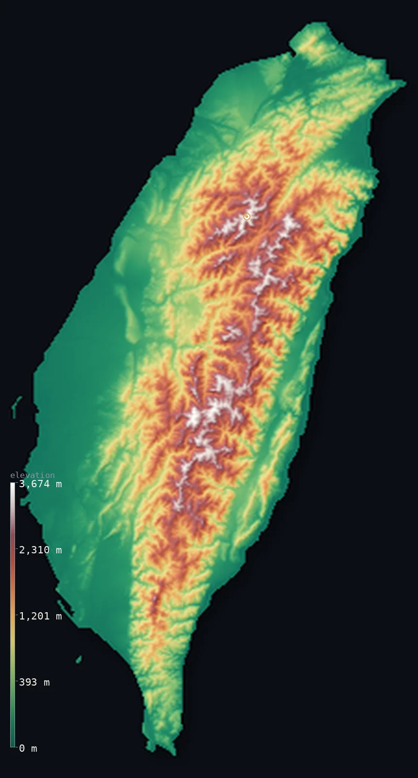
Taiwan’s highest point is Yushan (Jade Mountain) at 12,966 ft (3,952 m); its lowest is South China Sea at 0 ft (0 m); the mean elevation is 2,523 ft (769 m).
Taiwan is a strikingly mountainous island. A high spine of mountains — the Central Mountain Range — runs the length of it from north to south, rising to Yushan (Jade Mountain) at 12,966 ft (3,952 m), one of the highest peaks of the western Pacific and remarkably high for an island of this size. The mountains dominate the eastern two-thirds of Taiwan, dropping steeply to a rugged east coast, while to the west they descend more gradually through hills to a broad coastal plain — the lowland where most of the island's cities and people are.
- Highest point📚
- 12,966 ft3,952 m
- Taiwan's highest point is Yushan — Jade Mountain — at 12,966 ft (3,952 m), near the centre of the island in the Central Mountain Range. It is the fourth-highest island summit on Earth, higher than any peak in Japan — an extraordinary height for so small an island, snow-dusted in winter and rising far above the ranges around it. Taiwan's mountainous spine holds dozens of peaks above 3,000 m; Yushan is the crown.
- Lowest point📚
- 0 ft0 m
- Taiwan's lowest point is the sea at sea level, around the island's coasts — a rugged, cliff-bound shore in the mountainous east, and the broad, low, densely settled coastal plain in the west.
- Mean elevation⚙
- 2,523 ft769 m
- Computed from the GLO-30 model, Taiwan's mean elevation is 2,523 ft (769 m) — a high figure for an island, and a measure of how mountainous Taiwan is: a high range fills most of the island, and only the western plain and the narrow eastern coast are truly low.
- Median elevation⚙
- 1,362 ft415 m
- Half of Taiwan lies below about 1,362 ft (415 m) — reflecting the island's lopsided form: the western coastal plain and foothills, though a minority of the area, hold enough low ground to pull the middle down, while the high Central Mountain Range lifts the average above it, leaving the median down among the hills and low mountains between the western plain and the high spine.
- Elevation range📚
- 12,966 ft3,952 m
- From the sea to the summit of Yushan, Taiwan's terrain climbs about 12,966 ft — an enormous range for so small an island, from coastal plain to a near-4,000 m peak within a short distance, one of the steepest sea-to-summit rises of any island on Earth.
- Above 1,000 m (3,281 ft)⚙
- 32%
- About 32% of Taiwan rises above 1,000 m (3,281 ft) — the Central Mountain Range and the ranges flanking it, which fill the eastern two-thirds of the island. The western coastal plain and the foothills are lower.
- Above 2,000 m (6,562 ft)⚙
- 12%
- Roughly 12% of Taiwan stands above 2,000 m (6,562 ft) — the high spine of the Central Mountain Range, a long belt of peaks above Yushan and its neighbours, snow-capped in winter and among the highest island terrain anywhere.
- Official area📚
- 13,892 mi²35,980 km²
- Taiwan covers about 13,900 sq mi (35,980 sq km) — an island off the southeastern coast of mainland Asia, dominated by a high mountain range running its length, with a broad coastal plain along its western side. (This map follows the territory mapped by the geoBoundaries dataset.)
- Forest cover📚
- 60.7%
- More than 60% of Taiwan is forested — well over half the island, dense forest cloaking the steep mountain slopes from subtropical lowland woodland up through temperate forest to near the peaks; the cultivated and built-up land is mostly the western plain.
Highest and lowest points
Taiwan's highest point is Yushan, or Jade Mountain, at 12,966 ft (3,952 m), rising near the centre of the island from the Central Mountain Range. It is the fourth-highest island summit on Earth, higher than any peak in Japan — an exceptional height for an island, standing nearly 4,000 m above a sea that is never far away, and snow-dusted in winter above its forested flanks. Taiwan's mountainous backbone carries more than two hundred peaks above 3,000 m along its length; Yushan is the highest of them all, the summit of one of the most steeply mountainous islands on Earth.
source ↗Taiwan's lowest point is the sea at sea level, around a coast of two very different characters. In the east, the Central Mountain Range drops almost straight to the Pacific in high cliffs and a narrow, rugged shore. In the west, the mountains descend more gently through foothills to a broad coastal plain — flat, low, and fertile, this western lowland holds most of Taiwan's cities, farmland, and population, from Taipei in the north to Kaohsiung in the south.
source ↗Taiwan at a glance
Yushan (3,952 m) gives Taiwan the fourth-highest maximum elevation of any island on Earth — higher than any peak in Japan.
source ↗Taiwan has 268 peaks above 3,000 m - one of the highest concentrations of tall mountains of any island in the world.
source ↗Yushan holds the highest point on the Tropic of Cancer, and once carried the only glaciers ever known on that line of latitude.
source ↗The mountains are still rising, pushed up by the collision of the Eurasian and Philippine Sea plates.
source ↗On the east, the mountains fall so steeply to the Pacific that there is almost no coastal plain.
source ↗
Elevation profile of Taiwan
The largest share of land, 41%, falls in the 0–250 m band, with the land split almost evenly above and below 500 m (1,640 ft).
- below 500 m (1,640 ft)54%
- 500–1,000 m15%
- 1,000–2,000 m20%
- above 2,000 m (6,562 ft)12%
Highest peaks of Taiwan
| Peak | Elevation | Range | Note |
|---|---|---|---|
| Yushan (Jade Mountain)↗ | 12,966 ft3,952 m | Yushan Range | Highest point of Taiwan — the fourth-highest island summit on Earth. |
| Xueshan (Snow Mountain)↗ | 12,749 ft3,886 m | Xueshan Range | The second-highest peak in Taiwan, high point of the Xueshan (Snow Mountain) range. |
| Xiuguluan Mountain↗ | 12,664 ft3,860 m | Central Mountain Range | The highest peak of the Central Mountain Range, the island's main spine. |
| Mabolasi Mountain↗ | 12,418 ft3,785 m | Central Mountain Range | One of Taiwan's highest peaks, in the Yushan National Park area. |
| Nanhu Mountain (Nanhudashan)↗ | 12,277 ft3,742 m | Central Mountain Range | A great peak of the northern Central Mountain Range. |
Taiwan: the mountain spine, the eastern cliffs, and the western plain
The Central Mountain Range (the spine)
A high range of mountains runs the length of Taiwan from north to south — the Central Mountain Range and the ranges beside it — filling the eastern two-thirds of the island and holding Yushan and hundreds of other high peaks. Steep, forested, and snow-capped in winter, it is the mountainous core of the island.
The eastern coast
On the island's eastern side the mountains drop almost straight to the Pacific — a rugged, cliff-bound coast with only a narrow strip of lowland, including the deep gorges where rivers cut down from the range. Steep and dramatic, it is the wild, thinly settled side of Taiwan.
The western plain and foothills
West of the mountains the land descends through foothills to a broad, low coastal plain — flat, fertile, and densely settled, this western lowland holds most of Taiwan's cities, industry, farmland, and people, from Taipei to Kaohsiung. It is the island's populous, low-lying heart.
How to read this map
Color shows elevation; the raised relief shows real terrain. On this map Taiwan reads as a mountainous island tilted west — a high spine of browns and whites running north to south down the centre and east, dropping sharply to the eastern coast, and descending more gently through foothills to the low green western plain where the cities are.
The 3D relief is the actual GLO-30 elevation data, exaggerated vertically so the high spine and the western plain both show — though Taiwan's own relief is dramatic enough that it barely needs it; the ×N relief slider controls how much. Tap anywhere to read that point's exact elevation.
City elevations in Taiwan
Taiwan's cities cluster on the western coastal plain — Taipei in a basin in the north, Kaohsiung and Tainan on the southwestern coast, Taichung in the centre-west, with Hsinchu, Chiayi, and others along the plain. Only Hualien and Taitung sit on the mountainous east, on narrow strips of coastal lowland; the population is overwhelmingly western and low-lying.
| City | Population | Elevation |
|---|---|---|
| Taipeicapitalthe capital, in a basin in the north ↗ | 7,871,900 | 36 ft11 m |
| Taichungin the centre-west on the coastal plain ↗ | 2,850,285 | 302 ft92 m |
| Kaohsiungthe main southern port, on the southwestern coast ↗ | 2,737,660 | 36 ft11 m |
| Tainanon the southwestern coastal plain, the island's oldest city ↗ | 1,856,642 | 79 ft24 m |
| Hsinchuon the northwestern coastal plain ↗ | 453,536 | 98 ft30 m |
| Chiayi Cityon the southwestern plain, below the Alishan mountains ↗ | 263,188 | 131 ft40 m |
| Badein the north near Taoyuan, on the low terraced plain ↗ | 209,148 | 492 ft150 m |
| Douliuon the western plain in the centre-west ↗ | 107,924 | 187 ft57 m |
| Taitungon the narrow southeastern coastal lowland ↗ | 103,260 | 66 ft20 m |
| Hualien Cityon the rugged east coast, on a narrow coastal strip ↗ | 99,458 | 36 ft11 m |
Elevation sampled at each city centre from the Copernicus GLO-30 model. Cities and population from GeoNames (CC-BY 4.0).
Taiwan in comparison
Taiwan's terrain rises 12,966 ft (3,952 m) from sea level to Yushan (Jade Mountain) — about 45% of the height of Mount Everest, the world's highest point at 29,032 ft (8,849 m).
- Japan's mean elevation is 1,299 ft — 1,224 ft lower; its high point, Mount Fuji (Fujisan), reaches 12,388 ft (3,776 m), 577 ft below. Japan elevation map →
- Philippines's mean elevation is 1,053 ft — 1,470 ft lower; its high point, Mount Apo, reaches 9,692 ft (2,954 m), 3,274 ft below. Philippines elevation map →
- South Korea's mean elevation is 860 ft — 1,663 ft lower; its high point, Jirisan (Cheonwangbong), reaches 6,283 ft (1,915 m), 6,683 ft below. South Korea elevation map →
Frequently asked questions
What is the highest point in Taiwan?
- Yushan (Jade Mountain), 12,966 ft (3,952 m), in the Central Mountain Range near the island's centre — the highest peak of Taiwan and the fourth-highest island summit on Earth, exceptionally high for an island.
What is the lowest point in Taiwan?
- The sea at sea level, around the coasts — a rugged cliff-bound shore in the mountainous east, and the broad low coastal plain in the west.
What is the average elevation of Taiwan?
- Computed from the Copernicus GLO-30 model, the area-weighted mean is 2,523 ft (769 m) — high for an island, because a mountain range fills most of Taiwan, with only the western plain and narrow eastern coast truly low.
How mountainous is Taiwan?
- Very — a high range runs the length of the island, filling its eastern two-thirds, with more than two hundred peaks above 3,000 m and the summit, Yushan, near 4,000 m. Only the western plain is extensively low.
Why is Taiwan's population on the west side?
- Because the west is where the low ground is — the mountains descend gradually westward to a broad coastal plain, while the eastern side drops steeply to a rugged coast with little lowland. The plain holds most cities and farmland.
Is this a topographic, relief, contour, or elevation map of Taiwan?
- They describe the same thing — terrain height. This page renders the island's actual elevation surface in interactive 3D and reports the statistics computed from it.
About this map
The terrain is rendered from the Copernicus GLO-30 digital elevation model (ESA), masked to the TWN-ADM0 boundary from geoBoundaries (gbOpen). Elevation statistics are computed directly from the model; peak names and researched facts are sourced and cited. See the methodology for the full pipeline.
Our area-weighted mean, computed from the Copernicus GLO-30 model, is 2,523 ft (769 m); no authority publishes a mean elevation (No authoritative published mean elevation). No standard reference publishes a mean elevation for Taiwan; the page reports the area-weighted figure computed from the Copernicus GLO-30 model. It is high for an island — about 769 m — because a mountain range fills most of Taiwan, with only the western coastal plain and the narrow eastern shore truly low.
Surveyed national figures: official area · forest cover · high point.
Rendered from Copernicus GLO-30 (ESA, 2021 release), boundaries from geoBoundaries. Generated 2026-07-07.