Philippines Elevation Map — Topographic & 3D Terrain
Explore the terrain of the Philippines in interactive 3D, built from Copernicus GLO-30 satellite elevation data — a volcanic archipelago of thousands of mountainous islands. Drag to rotate, scroll to zoom, and tap any point to read its elevation.
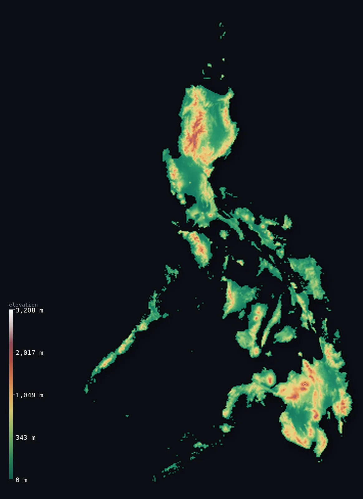
Philippines’s highest point is Mount Apo at 9,692 ft (2,954 m); its lowest is Philippine Sea at 0 ft (0 m); the mean elevation is 1,053 ft (321 m).
The Philippines is a nation of more than 7,600 islands, and they are mountainous almost everywhere. Volcanic ranges run down the larger islands — Luzon in the north, the Visayas in the middle, Mindanao in the south — rising straight from narrow coasts to forested interiors, with active volcanoes among them. The highest is Mount Apo on Mindanao, a volcano reaching 9,692 ft (2,954 m). The islands are steep: most of the country is hill and mountain, with the lowland confined to coastal plains and river valleys.
- Highest point📚
- 9,692 ft2,954 m
- The Philippines' highest point is Mount Apo at 9,692 ft (2,954 m), a large volcano in the southeast of Mindanao — the highest peak in the archipelago, forested to its upper slopes and ringed by hot springs and fumaroles that mark it as still-active volcanic country.
- Lowest point📚
- 0 ft0 m
- The Philippines' lowest point is the sea at sea level, around the coasts of its thousands of islands — a shoreline of reef, bay, and mangrove, backed almost immediately by rising ground on most of the larger islands.
- Mean elevation⚙
- 1,053 ft321 m
- Computed from the GLO-30 model, the mean elevation of the Philippines is 1,053 ft (321 m) — a moderate figure for such a mountainous country, because although the islands rise steeply, much of the population and the land area sits on the narrow coastal plains between the ranges and the sea.
- Median elevation⚙
- 577 ft176 m
- Half of the Philippines lies below 577 ft (176 m) — below the mean, the mark of an archipelago whose islands climb quickly from the coast: substantial high interior on the larger islands, set against the coastal lowlands where most Filipinos live.
- Elevation range📚
- 9,692 ft2,954 m
- From the sea to the summit of Mount Apo, the Philippines spans about 9,690 ft — gained again and again across the archipelago, as each major island rises from its coasts to a mountainous, often volcanic spine.
- Above 1,000 m (3,281 ft)⚙
- 7%
- About 7% of the Philippines rises above 1,000 m (3,281 ft) — the volcanic cordilleras of Luzon, the interior ranges of Mindanao, and the higher peaks of the Visayas, forested highland above the crowded coasts.
- Official area📚
- 115,831 mi²300,000 km²
- The Philippines covers about 116,000 sq mi (300,000 sq km) across more than 7,600 islands, the largest being Luzon in the north and Mindanao in the south, with the Visayas between them.
- Forest cover📚
- 27.8%
- About 27.8% of the Philippines is forested — tropical rainforest on the mountainous interiors of the larger islands, much reduced by logging and cultivation, with mangrove along the coasts.
Highest and lowest points
The Philippines' highest point is Mount Apo, 9,692 ft (2,954 m), a massive volcano in the southeast of Mindanao — the highest peak in the archipelago. Forested to its upper slopes and surrounded by hot springs, fumaroles, and boiling mud, it is a solfataric volcano, still geologically alive, and a national park sheltering the Philippine eagle. The Philippines lies along the Pacific Ring of Fire, and Apo is the tallest of the many volcanoes that give the islands their height.
source ↗The Philippines' lowest point is the sea at sea level, around the coasts of its more than 7,600 islands — a vast combined coastline of reef, bay, and mangrove. On most of the larger islands the coastal plain is narrow, and the land rises quickly inland to volcanic ranges; the flat ground is concentrated in these coastal strips and in the river valleys and lake basins between the mountains, where most of the country's people live.
source ↗Philippines at a glance
The highest point of the Philippines, Mount Apo (2,954 m), is an active volcano on Mindanao, ringed by hot springs, fumaroles, and boiling mud.
source ↗The Philippines is made up of more than 7,600 islands, most of them mountainous, strung along the Pacific Ring of Fire.
source ↗The islands sit on the Ring of Fire and carry many active volcanoes — among them Mayon, famous for its near-perfect cone, and Taal, one of the smallest and most active.
source ↗The three main island groups — Luzon in the north, the Visayas in the centre, and Mindanao in the south — each carry their own mountain ranges.
source ↗Luzon's Cordillera Central holds the mountain rice terraces of the Ifugao, carved into steep slopes over centuries.
source ↗Just east of the islands lies the Philippine Trench, over 10,000 m deep — one of the deepest places in any ocean.
source ↗
Elevation profile of Philippines
The largest share of land, 53%, falls in the 0–200 m band, and 77% of the territory lies below 500 m (1,640 ft).
- below 500 m (1,640 ft)77%
- 500–1,000 m16%
- 1,000–2,000 m6%
- above 2,000 m (6,562 ft)<1%
Highest peaks of Philippines
| Peak | Elevation | Range | Note |
|---|---|---|---|
| Mount Apo↗ | 9,692 ft2,954 m | Apo-Talomo Range (Mindanao) | Highest point of the Philippines, an active volcano on Mindanao. |
| Mount Dulang-dulang↗ | 9,639 ft2,938 m | Kitanglad Range (Mindanao) | The second-highest peak in the country, in the Kitanglad Range of Bukidnon. |
| Mount Pulag↗ | 9,587 ft2,922 m | Cordillera Central (Luzon) | The highest peak of Luzon and the third-highest in the country. |
| Mount Kanlaon↗ | 8,087 ft2,465 m | Negros (Visayas) | An active volcano and the highest peak of the central Visayas islands. |
| Mayon↗ | 8,081 ft2,463 m | Bicol (Luzon) | A famously symmetrical active volcano in southeastern Luzon. |
Luzon, the Visayas, and Mindanao
Luzon (north)
The largest island, in the north, and the most varied — the Cordillera Central and Sierra Madre ranges running down it, holding the Ifugao rice terraces and, at its heart, active volcanoes like Mayon and Taal. The capital, Manila, sits on a coastal lowland between the ranges.
The Visayas (centre)
The central cluster of islands — Cebu, Negros, Panay, Leyte, Samar and others — mountainous and volcanic, separated by narrow seas, with coastal plains around their rugged interiors. A dense scatter of steep islands between Luzon and Mindanao.
Mindanao (south)
The large southern island, carrying the country's high point, Mount Apo, and its most extensive mountain ranges — volcanic cordilleras and interior highlands, with broad river valleys and coastal plains around them. The most mountainous of the three groups.
How to read this map
Color shows elevation; the raised relief shows real terrain. On this map the Philippines reads as a scatter of steep green-and-brown islands running north to south — the ranges of Luzon at the top, the mountainous Visayas in the middle, and Mindanao with the high point of Mount Apo at the bottom.
The 3D relief is the actual GLO-30 elevation data, exaggerated vertically so the islands' steep rise from the sea shows; the ×N relief slider controls how much. Tap anywhere to read that point's exact elevation.
City elevations in Philippines
Philippine cities crowd the coastal lowlands — Manila and its metropolis on Luzon, Cebu in the Visayas, Davao on Mindanao — each on a coastal plain beneath the mountainous interior. The highlands hold far fewer people.
| City | Population | Elevation |
|---|---|---|
| Davaoon the southeastern coast of Mindanao, beneath Mount Apo ↗ | 1,848,947 | 23 ft7 m |
| Manilacapitalthe capital, on a coastal lowland of Luzon between the mountain ranges, at the heart of one of the world's most populous urban areas ↗ | 1,600,000 | 30 ft9 m |
| Budta | 1,273,715 | 13 ft4 m |
| Zamboanga | 1,018,849 | 26 ft8 m |
| Cebu Citya port city in the central Visayas ↗ | 965,332 | 128 ft39 m |
| Cagayan de Oro | 741,617 | 30 ft9 m |
| Iloilo | 473,728 | 23 ft7 m |
| Baguio | 272,714 | 4,829 ft1,472 m |
| Tacloban | 259,353 | 23 ft7 m |
| Puerto Princesa | 222,673 | 62 ft19 m |
Elevation sampled at each city centre from the Copernicus GLO-30 model. Cities and population from GeoNames (CC-BY 4.0).
Philippines in comparison
Philippines's terrain rises 9,692 ft (2,954 m) from sea level to Mount Apo — about 33% of the height of Mount Everest, the world's highest point at 29,032 ft (8,849 m).
- Indonesia's mean elevation is 1,112 ft — 59 ft higher; its high point, Puncak Jaya (Carstensz Pyramid), reaches 16,024 ft (4,884 m), 6,332 ft above. Indonesia elevation map →
- Malaysia's mean elevation is 902 ft — 151 ft lower; its high point, Mount Kinabalu (Low's Peak), reaches 13,435 ft (4,095 m), 3,743 ft above. Malaysia elevation map →
- Taiwan's mean elevation is 2,523 ft — 1,470 ft higher; its high point, Yushan (Jade Mountain), reaches 12,966 ft (3,952 m), 3,274 ft above. Taiwan elevation map →
Frequently asked questions
What is the highest point in the Philippines?
- Mount Apo, 9,692 ft (2,954 m), an active volcano in the southeast of Mindanao — the highest peak in the archipelago.
What is the lowest point in the Philippines?
- The sea at sea level, around the coasts of its more than 7,600 islands.
What is the average elevation of the Philippines?
- Computed from the Copernicus GLO-30 model, the area-weighted mean is 1,053 ft (321 m) — moderate, because although the islands are steep, much of the land and population sits on the narrow coastal plains.
Is the Philippines volcanic?
- Yes — the islands lie along the Pacific Ring of Fire and carry many active volcanoes, including Mount Apo (the high point), the near-perfect cone of Mayon, and the small, restless Taal.
What are the main island groups of the Philippines?
- Three — Luzon in the north, the Visayas in the centre, and Mindanao in the south — each carrying its own mountain ranges, with Mindanao holding the high point.
Is this a topographic, relief, contour, or elevation map of the Philippines?
- They describe the same thing — terrain height. This page renders the country's actual elevation surface in interactive 3D and reports the statistics computed from it.
About this map
The terrain is rendered from the Copernicus GLO-30 digital elevation model (ESA), masked to the PHL-ADM0 boundary from geoBoundaries (gbOpen). Elevation statistics are computed directly from the model; peak names and researched facts are sourced and cited. See the methodology for the full pipeline.
Our area-weighted mean, computed from the Copernicus GLO-30 model, is 1,053 ft (321 m); the figure commonly cited elsewhere is 1,450 ft (442 m) (CIA World Factbook). The Philippines is a mountainous archipelago of thousands of islands, most with rugged volcanic interiors fringed by narrow coastal plains, so its mean elevation is modest; the page reports the area-weighted figure computed from the Copernicus GLO-30 model over the rendered islands.
Surveyed national figures: official area · forest cover · high point.
Rendered from Copernicus GLO-30 (ESA, 2021 release), boundaries from geoBoundaries. Generated 2026-07-18.