Japan Elevation Map — Topographic & 3D Terrain
Explore the terrain of Japan in interactive 3D, built from Copernicus GLO-30 satellite elevation data — a chain of volcanic islands where steep mountains meet the sea. Drag to rotate, scroll to zoom, and tap any point to read its elevation.
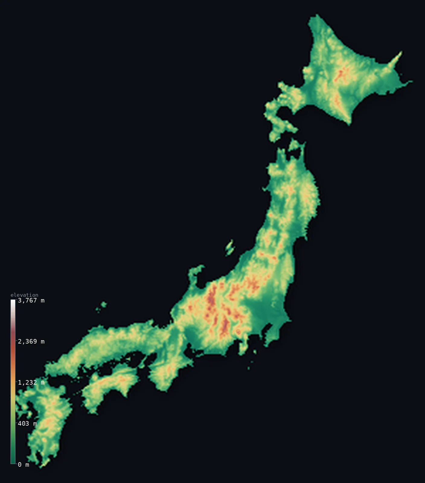
Japan’s highest point is Mount Fuji (Fujisan) at 12,388 ft (3,776 m); its lowest is Hachirōgata at −13 ft (−4 m); the mean elevation is 1,299 ft (396 m).
Japan is a low, crumpled country crowned by a single great volcano. Nearly three-quarters of it is mountainous, yet its ranges are modest — only about 8% of the land clears 1,000 m (3,281 ft) — and above them all stands Mount Fuji, a near-perfect volcanic cone reaching 12,388 ft (3,776 m). The country's people are pressed onto the narrow coastal plains between the mountains and the sea, some of the most crowded flat land on Earth.
- Highest point📚
- 12,388 ft3,776 m
- Japan's highest point is Mount Fuji at 12,388 ft (3,776 m) — a dormant volcano so much taller than everything around it that it stands alone on the skyline, sacred for centuries and visible from Tokyo on a clear day.
- Lowest point📚
- −13 ft−4 m
- Japan's lowest natural point is Hachiro-gata, a reclaimed lagoon bed about 13 ft (4 m) below sea level — one of the few places in this steep country where the land dips beneath the tide, and then only because it was drained.
- Mean elevation⚙
- 1,299 ft396 m
- Japan's mean elevation computed from the GLO-30 model is just 1,299 ft (396 m) — low for a country that feels so mountainous, because its mountains, though everywhere, are not tall; they corrugate the land rather than pile it high.
- Median elevation⚙
- 928 ft283 m
- Half of Japan lies below 928 ft (283 m), a reminder that the country's character is not great height but relentless slope — endless steep, forested hills falling straight to narrow valleys and the coast.
- Elevation range📚
- 12,402 ft3,780 m
- From the drained bed of Hachiro-gata to Fuji's summit, Japan spans about 12,400 ft — a wide range for a country of islands, and one crossed abruptly, since the mountains rise almost directly from the shore with little plain between.
- Above 1,000 m (3,281 ft)⚙
- 8%
- Only about 8% of Japan rises above 1,000 m (3,281 ft) — the spine of the Japanese Alps through the main island of Honshu, and the higher volcanoes. For all its mountainous reputation, high ground is the exception.
- Official area📚
- 145,937 mi²377,975 km²
- Japan covers about 146,000 sq mi (378,000 sq km) across a long arc of islands — but so much of it is too steep to build on that its great cities are crammed onto a small fraction of flat coastal land.
- Forest cover📚
- 67%
- About 67% of Japan is forested — one of the highest shares in the developed world — because the steep, mountainous interior was never worth clearing, leaving the country green in the hills and dense only along the coasts.
Highest and lowest points
Japan's highest point is Mount Fuji (Fujisan), 12,388 ft (3,776 m) — a dormant stratovolcano on Honshu that last erupted in 1707. It rises so far above the surrounding country, and in such a symmetrical cone, that it has been a sacred mountain and a national symbol for centuries; on a clear day it is visible from Tokyo, 100 km away. It is the highest of the many volcanoes that build the Japanese arc.
source ↗Japan's lowest natural point is Hachiro-gata on Honshu, about 13 ft (4 m) below sea level — a former lagoon drained for farmland in the 20th century. In a country this steep, genuine low ground is rare; almost everywhere the land either rises into mountains or drops straight into the sea, leaving little that sits below the tide.
source ↗Japan at a glance
Mount Fuji, 3,776 m, is a dormant volcano and Japan's highest point — it last erupted in 1707 and remains a sacred national symbol.
source ↗About three-quarters of Japan is mountainous, yet only around 8% of the country rises above 1,000 m — the ranges are pervasive but low.
source ↗Japan sits on the Pacific Ring of Fire, where four tectonic plates meet, giving it over 100 active volcanoes and frequent earthquakes.
source ↗Because so little of Japan is flat, its major cities are packed onto narrow coastal plains — the Kanto Plain around Tokyo is the largest.
source ↗Japan's mountains are so steep and forested that about two-thirds of the country remains under forest.
source ↗The Japanese Alps of central Honshu rise above 3,000 m, their highest peak Kita-dake reaching 3,193 m — the country's high point after Fuji.
source ↗
Elevation profile of Japan
The largest share of land, 46%, falls in the 0–250 m band, and 70% of the territory lies below 500 m (1,640 ft).
- below 500 m (1,640 ft)70%
- 500–1,000 m22%
- 1,000–2,000 m8%
- above 2,000 m (6,562 ft)<1%
Highest peaks of Japan
| Peak | Elevation | Range | Note |
|---|---|---|---|
| Mount Fuji (Fujisan)↗ | 12,388 ft3,776 m | Fuji Volcanic Zone | Highest point of Japan; an active stratovolcano and the country's sacred symbol. Stands 583 m above the next-highest peak. |
| Kita-dake↗ | 10,476 ft3,193 m | Akaishi Mountains (Southern Alps) | Japan's second-highest mountain and the highest of the Japanese Alps; a granite peak, unlike volcanic Fuji. |
| Okuhotaka-dake↗ | 10,466 ft3,190 m | Hida Mountains (Northern Alps) | Highest peak of the Hida range and third-highest in Japan, in the rugged Northern Japanese Alps. |
| Ainodake↗ | 10,463 ft3,189 m | Akaishi Mountains (Southern Alps) | Fourth-highest in Japan, on the main ridge of the Southern Alps. |
| Yarigatake↗ | 10,433 ft3,180 m | Hida Mountains (Northern Alps) | The 'Matterhorn of Japan', a sharp spearhead peak among the most prized climbs in the Northern Alps. |
| Asahi-dake↗ | 7,516 ft2,291 m | Daisetsuzan (Hokkaidō) | Highest mountain on Hokkaidō, an active volcano in the Daisetsuzan range far to the north. |
The making of the Japanese landscape
The Japanese Alps (central Honshu)
The high backbone of Japan runs through central Honshu — the Hida, Kiso, and Akaishi ranges, together called the Japanese Alps, rising above 3,000 m. These are the country's only truly high mountains apart from the volcanoes, steep and snow-covered in winter.
The volcanic ranges and Fuji
Volcanoes shape the whole arc, from Hokkaido to Kyushu, and above them all stands Mount Fuji (3,776 m). More than a hundred are active, a consequence of Japan's place on the Ring of Fire, and their cones punctuate the ranges the length of the country.
The coastal plains
Japan's flat land is scarce and precious — narrow plains where the rivers reach the sea, above all the Kanto Plain around Tokyo. On these small fractions of level ground the country's cities and farmland are densely concentrated.
Hokkaido and the north
The northern island of Hokkaido is cooler and more open, with rolling volcanic uplands and the Ishikari plain — the least crowded, most recently settled part of the country.
How to read this map
Color shows elevation; the raised relief shows real terrain. On this map Japan reads as a corrugated green ribbon — low browns rising to the white of the Alps and Fuji, dropping fast to the blue-edged coasts.
The 3D relief is the actual GLO-30 elevation data, exaggerated vertically so the steep, close-packed mountains stand out; the ×N relief slider controls how much. Tap anywhere on the map to read that point's exact elevation.
City elevations in Japan
Japan's cities sit low and coastal almost without exception — Tokyo, Osaka, and the rest crowd the narrow plains where the mountains meet the sea. Only a few inland cities rise even modestly above the tide.
| City | Population | Elevation |
|---|---|---|
| Tokyocapitalthe capital, spread across the Kanto Plain — Japan's largest area of flat land — near sea level ↗ | 9,733,276 | 128 ft39 m |
| Osakaon the flat Kansai coast at the head of Osaka Bay, barely above sea level ↗ | 2,753,862 | 20 ft6 m |
| Nagoya | 2,332,176 | 59 ft18 m |
| Sapporoon the Ishikari plain of Hokkaido, the main city of the cooler north ↗ | 1,973,832 | 69 ft21 m |
| Fukuoka | 1,612,392 | 23 ft7 m |
| Hiroshima | 1,200,754 | 23 ft7 m |
| Sendai | 1,096,704 | 167 ft51 m |
| Niigata | 797,591 | 13 ft4 m |
| Okayama | 724,691 | 16 ft5 m |
| Shizuoka | 693,389 | 79 ft24 m |
Elevation sampled at each city centre from the Copernicus GLO-30 model. Cities and population from GeoNames (CC-BY 4.0).
Japan in comparison
Japan's terrain rises 12,402 ft (3,780 m) from Hachirōgata, 13 ft (4 m) below sea level to Mount Fuji (Fujisan) — about 43% of the height of Mount Everest, the world's highest point at 29,032 ft (8,849 m).
- New Zealand's mean elevation is 1,608 ft — 308 ft higher; its high point, Aoraki / Mount Cook, reaches 12,218 ft (3,724 m), 171 ft below. New Zealand elevation map →
- Chile's mean elevation is 4,341 ft — 3,041 ft higher; its high point, Ojos del Salado, reaches 22,615 ft (6,893 m), 10,226 ft above. Chile elevation map →
- Switzerland's mean elevation is 4,301 ft — 3,002 ft higher; its high point, Dufourspitze (Monte Rosa), reaches 15,203 ft (4,634 m), 2,815 ft above. Switzerland elevation map →
Frequently asked questions
What is the highest point in Japan?
- Mount Fuji, 12,388 ft (3,776 m), a dormant volcano on Honshu - the country's highest peak and a sacred national symbol.
What is the lowest point in Japan?
- Hachiro-gata, a reclaimed lagoon bed on Honshu about 13 ft (4 m) below sea level - Japan has very little land below the tide.
How mountainous is Japan?
- About three-quarters of Japan is mountainous, though the ranges are mostly low - only around 8% of the country rises above 1,000 m - which is why its cities crowd the narrow coastal plains.
Why does Japan have so many volcanoes?
- Japan lies on the Pacific Ring of Fire, where several tectonic plates meet, giving it more than 100 active volcanoes and frequent earthquakes.
What is the average elevation of Japan?
- Computed from the Copernicus GLO-30 model, Japan's area-weighted mean is 1,299 ft (396 m) - low for a country three-quarters mountainous, because its ranges corrugate the land rather than pile it high.
Is this a topographic, relief, contour, or elevation map of Japan?
- They describe the same thing - terrain height. This page renders the country's actual elevation surface in interactive 3D and reports the statistics computed from it.
About this map
The terrain is rendered from the Copernicus GLO-30 digital elevation model (ESA), masked to the JPN-ADM0 boundary from geoBoundaries (gbOpen). Elevation statistics are computed directly from the model; peak names and researched facts are sourced and cited. See the methodology for the full pipeline.
Our area-weighted mean, computed from the Copernicus GLO-30 model, is 1,299 ft (396 m); the figure commonly cited elsewhere is 1,437 ft (438 m) (CIA World Factbook). About 73% of Japan is mountainous and the populated plains are small and coastal, so the mean reflects extensive high interior terrain; the page reports the area-weighted figure computed from the Copernicus GLO-30 model.
Surveyed national figures: official area · forest cover · high point.
Rendered from Copernicus GLO-30 (ESA, 2021 release), boundaries from geoBoundaries. Generated 2026-06-21.