North Korea Elevation Map
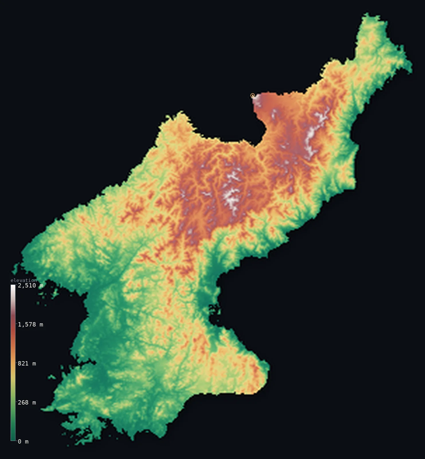
North Korea’s highest point is Paektu (Janggun Peak) at 9,003 ft (2,744 m); its lowest is Sea of Japan (East Sea) at 0 ft (0 m); the mean elevation is 1,926 ft (587 m).
- Highest point📚
- 9,003 ft2,744 m
- Mount Paektu, a volcano on the Chinese border.
- Lowest point📚
- 0 ft0 m
- Sea level on the east and west coasts.
- Mean elevation⚙
- 1,926 ft587 m
- Computed from the GLO-30 surface model across the country.
- Median elevation⚙
- 1,460 ft445 m
- Half of North Korea lies below this height.
- Elevation range📚
- 9,003 ft2,744 m
- From the sea to Paektu's 2,744 m.
- Above 1,000 m (3,281 ft)⚙
- 23%
- The northern mountains and the Kaema Plateau.
- Official area📚
- 46,540 mi²120,538 km²
- A mountainous country on the northern Korean Peninsula.
- Forest cover📚
- 42%
- Heavily forested - about two-fifths, mostly in the mountains.
Highest and lowest points
The highest point of North Korea at 2,744 m - Mount Paektu (Korean Baekdu; Chinese Changbai), an active stratovolcano on the China-North Korea border. Its highest peak, Janggun Peak, is on the North Korean side of the caldera rim, so it is a border summit; the crater holds Heaven Lake (Chonji) at about 2,190 m, split between the two countries. (Britannica gives 2,750 m.)
source ↗Paektu (Janggun Peak) is a border summit: its peak lies just outside the generalized North Korea boundary, so the highest fully in-territory land pixel in the model is 8,862 ft (2,701 m). The headline figure above is the surveyed elevation of the recognised national high point.
North Korea at a glance
North Korea's high point, Mount Paektu, is an active volcano whose 946 CE 'Millennium' eruption was one of the most powerful in the last 5,000 years.
source ↗Its caldera holds Heaven Lake (Chonji), one of the highest and deepest crater lakes in the world, sitting at about 2,190 m and split between North Korea and China.
source ↗Paektu is the source of the Yalu (Amnok) and Tumen rivers, which form almost the entire border with China and Russia.
source ↗The basalt Kaema Plateau south of Paektu is so high and cold it is nicknamed the 'roof of Korea'.
source ↗Mountains and uplands cover most of the country, with flat farmland confined mainly to the western coast.
source ↗The summit of Paektu rises about 3 mm a year as magma slowly accumulates beneath the volcano.
source ↗
Elevation profile of North Korea
The largest share of land, 31%, falls in the 0–200 m band, with the land split almost evenly above and below 500 m (1,640 ft).
- below 500 m (1,640 ft)54%
- 500–1,000 m23%
- 1,000–2,000 m22%
- above 2,000 m (6,562 ft)1%
Highest peaks of North Korea
| Peak | Elevation | Range | Note |
|---|---|---|---|
| Paektu (Janggun Peak)↗ | 9,003 ft2,744 m | Paektu massif (north, China border) | Highest point of North Korea and the Korean Peninsula, a volcanic caldera on the Chinese border. |
| Kwanmo-bong↗ | 8,337 ft2,541 m | Hamgyong Mountains (northeast) | The second-highest peak in North Korea, in the rugged northeastern Hamgyong range. |
| Nangnim-san↗ | 6,608 ft2,014 m | Nangnim Mountains (north-central) | A high peak of the Nangnim range, the north-central mountain spine. |
| Myohyang-san↗ | 6,263 ft1,909 m | Myohyang Mountains (central) | A famous scenic massif north of Pyongyang. |
| Kumgang-san↗ | 5,374 ft1,638 m | Diamond Mountains (southeast coast) | The scenic Diamond Mountains near the east coast and the southern border. |
Terrain regions of North Korea
North Korea's high point, Mount Paektu, is an active volcano whose 946 CE 'Millennium' eruption was one of the most powerful in the last 5,000 years. ↗
The northern mountains and plateaus
↗The high, rugged north - the volcanic Paektu massif and Kaema Plateau on the Chinese border, source of the Yalu (Amnok) and Tumen rivers - the loftiest and coldest part of the country.
The eastern ranges and coast
↗The Hamgyong and Nangnim mountains running down the spine and east side, dropping steeply to a narrow Sea of Japan (East Sea) coastal strip.
The western plains
↗The broader lowlands along the Yellow Sea (West Sea), drained by the Taedong and other rivers - the main farming region, holding Pyongyang and most of the population.
The northern mountains and the Kaema Plateau
the northThe north is the highest, wildest part of Korea. The volcanic Paektu massif rises on the Chinese border to 2,744 m, its caldera filled by the high crater lake Chonji (Heaven Lake) at about 2,190 m. South of it spreads the basalt Kaema Plateau, often called the 'roof of Korea', a cold upland around 1,500 m. The Yalu (Amnok) and Tumen rivers rise here and run along the Chinese and Russian borders.
The eastern ranges and coast
the east and centreThe Hamgyong Mountains of the northeast (Kwanmo-bong, 2,541 m) and the Nangnim Mountains of the centre form a high spine close to the east coast, so the land falls steeply to a narrow strip along the Sea of Japan. Most rivers are short and swift on this side.
The western plains
the westWest of the mountains the land descends in steps to broader coastal plains along the Yellow Sea, drained by longer, gentler rivers like the Taedong and Chongchon. This is the country's main agricultural lowland and holds Pyongyang and most of its people.
City elevations in North Korea
| City | Population | Elevation |
|---|---|---|
| PyongyangcapitalPyongyang, the capital, sits on the Taedong River in the lower western plains, the country's main lowland. ↗ | 3,222,000 | 125 ft38 m |
| Dandong | 631,973 | 39 ft12 m |
| Hamhŭng | 559,056 | 49 ft15 m |
| Kaesŏng | 338,155 | 128 ft39 m |
| Wŏnsan | 329,207 | 16 ft5 m |
| Chongjin | 327,000 | 20 ft6 m |
| Kaech’ŏn | 319,554 | 108 ft33 m |
| Sariwŏn-si | 310,100 | 56 ft17 m |
| Haeju | 222,396 | 167 ft51 m |
| Kanggye | 209,530 | 942 ft287 m |
Elevation sampled at each city centre from the Copernicus GLO-30 model. Cities and population from GeoNames (CC-BY 4.0).
North Korea in comparison
North Korea's terrain rises 9,003 ft (2,744 m) from sea level to Paektu (Janggun Peak) — about 31% of the height of Mount Everest, the world's highest point at 29,032 ft (8,849 m).
- South Korea's mean elevation is 860 ft — 1,066 ft lower; its high point, Jirisan (Cheonwangbong), reaches 6,283 ft (1,915 m), 2,720 ft below. South Korea elevation map →
- China's mean elevation is 6,014 ft — 4,088 ft higher; its high point, Mount Everest (Qomolangma), reaches 29,032 ft (8,849 m), 20,030 ft above. China elevation map →
- Japan's mean elevation is 1,299 ft — 627 ft lower; its high point, Mount Fuji (Fujisan), reaches 12,388 ft (3,776 m), 3,386 ft above. Japan elevation map →
Frequently asked questions
What is the highest point in North Korea?
- Mount Paektu, 9,003 ft (2,744 m), a volcano on the Chinese border - also the highest point on the whole Korean Peninsula.
What is the average elevation of North Korea?
- Computed from the Copernicus GLO-30 model, the area-weighted mean is 1,926 ft (587 m). North Korea is largely mountainous.
What is the lowest point in North Korea?
- Sea level, on both the Yellow Sea (west) and Sea of Japan (east) coasts.
Is Mount Paektu a volcano?
- Yes - an active stratovolcano with a summit caldera holding Heaven Lake. Its huge 946 CE eruption was one of the largest in recorded history.
Where are North Korea's lowlands?
- Mainly along the western (Yellow Sea) coast, drained by the Taedong and other rivers - this is the country's main farmland and holds Pyongyang.
Is this a topographic, relief, contour, or elevation map of North Korea?
- They describe the same thing - terrain height. This page renders North Korea's actual elevation surface in interactive 3D (a relief or topographic view) and reports the elevation statistics computed from it; a contour map shows the same data as lines of equal height.
About this map
The terrain is rendered from the Copernicus GLO-30 digital elevation model (ESA), masked to the PRK-ADM0 boundary from geoBoundaries (gbOpen). Elevation statistics are computed directly from the model; peak names and researched facts are sourced and cited. See the methodology for the full pipeline.
Our area-weighted mean, computed from the Copernicus GLO-30 model, is 1,926 ft (587 m); the figure commonly cited elsewhere is 1,969 ft (600 m) (CIA World Factbook). North Korea is largely mountainous - rugged ranges and high plateaus cover the north and east, with lowland plains mainly along the western coast - so its mean elevation is high; the page reports the area-weighted figure computed from the Copernicus GLO-30 model.
Surveyed national figures: official area · forest cover · high point.
Rendered from Copernicus GLO-30 (ESA, 2021 release), boundaries from geoBoundaries. Generated 2026-06-25.
Bordering countries · 3
North Korea shares a land border with these countries — open any one to compare its terrain and highest point.