Sri Lanka Elevation Map — Topographic & 3D Terrain
Explore the terrain of Sri Lanka in interactive 3D, built from Copernicus GLO-30 satellite elevation data — an island of central highlands ringed by broad coastal plains. Drag to rotate, scroll to zoom, and tap any point to read its elevation.
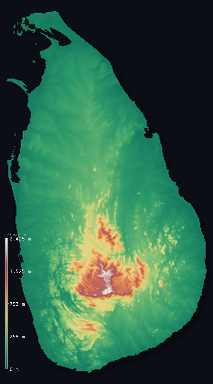
Sri Lanka’s highest point is Pidurutalagala at 8,281 ft (2,524 m); its lowest is Indian Ocean at 0 ft (0 m); the mean elevation is 574 ft (175 m).
Sri Lanka is an island built around a central massif. A tropical island in the Indian Ocean off the southeastern tip of India, it rises from broad, low coastal plains that ring most of its shore to a rugged core of mountains and high plateaus in the south-centre — the Central Highlands, where Pidurutalagala reaches 8,281 ft (2,524 m), the island's highest point. Most of Sri Lanka is low plain; the highlands are a compact, high heart, their slopes famous for tea, feeding the rivers that radiate out to the sea.
- Highest point📚
- 8,281 ft2,524 m
- Sri Lanka's highest point is Pidurutalagala at 8,281 ft (2,524 m), rising above the town of Nuwara Eliya in the Central Highlands of the south-centre — the highest summit of the compact mountain core that forms the island's roof. Nearby stands the more famous conical peak of Adam's Peak (Sri Pada), lower but revered; Pidurutalagala is the true high point of the highlands.
- Lowest point📚
- 0 ft0 m
- Sri Lanka's lowest point is the sea at sea level, around the island's coasts — a shore of broad, low coastal plains, lagoons, and beaches ringing most of the island, widest in the north and along the eastern and western coasts.
- Mean elevation⚙
- 574 ft175 m
- Computed from the GLO-30 model, Sri Lanka's mean elevation is 574 ft (175 m) — a low figure, reflecting an island that is mostly low coastal plain: broad lowlands ring the island, with the high ground confined to the compact Central Highlands of the south-centre, and only about 9% of the island rising even above 500 m.
- Median elevation⚙
- 243 ft74 m
- Half of Sri Lanka lies below about 243 ft (74 m) — a low figure that captures the island's form: the broad, low coastal plains cover so much of it that most of the island lies near the sea, with the Central Highlands a high but compact minority of the area.
- Elevation range📚
- 8,281 ft2,524 m
- From the sea to the summit of Pidurutalagala at 2,524 m, Sri Lanka's terrain climbs about 8,280 ft — the rise held in the compact Central Highlands of the south-centre, while the broad coastal plains that make up most of the island lie low and close to the sea.
- Above 1,000 m (3,281 ft)⚙
- 4%
- Only about 4% of Sri Lanka rises above 1,000 m (3,281 ft) — just the higher Central Highlands at the island's core. Almost the whole island is low: the broad coastal plains and the lower foothills that ring the mountains.
- Official area📚
- 25,332 mi²65,610 km²
- Sri Lanka covers about 25,300 sq mi (65,610 sq km) — an island in the Indian Ocean off the southeastern coast of India, mostly low coastal plain, rising to a compact core of mountains and high plateaus, the Central Highlands, in the south-centre.
- Forest cover📚
- 33.7%
- About 34% of Sri Lanka is forested — a fair share, including tropical rainforest in the wetter southwest (such as Sinharaja), monsoon forest and scrub in the drier north and east, and cloud forest on the highest slopes; much of the lowland and the highland tea country is cultivated.
Highest and lowest points
Sri Lanka's highest point is Pidurutalagala, 8,281 ft (2,524 m), rising above the hill town of Nuwara Eliya in the Central Highlands of the south-centre. It is the highest summit of the island's compact mountain core — a region of mountains, high plateaus, escarpments, and deep valleys, cooler and wetter than the lowlands, whose slopes are famous the world over for tea. Not far away rises Adam's Peak (Sri Pada), a striking conical mountain lower than Pidurutalagala but far more renowned, a pilgrimage site sacred to several religions. Pidurutalagala, though, is the island's true summit, the high point of the highlands from which Sri Lanka's rivers radiate out to the surrounding sea.
source ↗Sri Lanka's lowest point is the sea at sea level, around a coast of broad, low plains, lagoons, and long beaches. The coastal lowlands ring most of the island and are widest in the north — the flat Jaffna Peninsula and the northern plain — and along the eastern and western shores. These low plains, tropical and often intensively farmed or settled, make up the majority of Sri Lanka; from them the land rises inland, gently at first through foothills, then steeply into the Central Highlands at the island's heart.
source ↗Sri Lanka at a glance
Pidurutalagala is Sri Lanka's only ultra-prominent peak, though it rises only about 600 m above the plateau at its foot.
source ↗Its summit is a restricted military radar zone, so the highest peak in the country is off-limits to the public.
source ↗About four-fifths of Sri Lanka lies below 200 m - the high ground is packed into the small south-central highlands.
source ↗The sacred Adam's Peak (Sri Pada), though lower than several other summits, is far more famous and a major pilgrimage site.
source ↗The central highlands are sharply walled by escarpments, the most dramatic being the World's End precipice in Horton Plains.
source ↗
Elevation profile of Sri Lanka
The largest share of land, 81%, falls in the 0–200 m band, and 91% of the territory lies below 500 m (1,640 ft).
- below 500 m (1,640 ft)91%
- 500–1,000 m5%
- 1,000–2,000 m4%
- above 2,000 m (6,562 ft)<1%
Highest peaks of Sri Lanka
| Peak | Elevation | Range | Note |
|---|---|---|---|
| Pidurutalagala↗ | 8,281 ft2,524 m | Central Highlands | Highest point of Sri Lanka, above Nuwara Eliya; its summit is a restricted military zone. |
| Kirigalpotta↗ | 7,835 ft2,388 m | Central Highlands (Horton Plains) | The second-highest peak, in Horton Plains National Park - the highest summit open to the public. |
| Thotupola Kanda↗ | 7,733 ft2,357 m | Central Highlands (Horton Plains) | The third-highest peak, on the edge of the Horton Plains plateau. |
| Kudahagala↗ | 7,612 ft2,320 m | Central Highlands | A high summit of the central highlands near Horton Plains. |
| Adam's Peak (Sri Pada)↗ | 7,359 ft2,243 m | Central Highlands (Peak Wilderness) | A sacred, conical pilgrimage mountain in the southwest of the highlands, far more famous than its height suggests. |
Sri Lanka: the central massif, the coastal plains, and the zones
The Central Highlands (the core)
The high heart of Sri Lanka is the Central Highlands — a compact core of mountains, high plateaus, escarpments, and valleys in the south-centre, holding Pidurutalagala (the island's high point) and Adam's Peak. Cooler and wetter than the lowlands and famous for tea, they are the island's roof and its watershed, the rivers radiating out from here.
The coastal plains (the ring)
Broad, low coastal plains ring most of the island — flat, tropical lowland of beaches, lagoons, paddy fields, and towns, widest in the north (the Jaffna Peninsula and northern plain) and along the east and west coasts. Low and close to the sea, these plains make up the majority of Sri Lanka.
The wet and dry zones
Sri Lanka divides climatically as well as by height — a wet zone in the southwest and the highlands, rainforested and green, and a larger dry zone across the north and east, of monsoon forest and scrub. This divide, more than relief alone, shapes the island's landscapes and life.
How to read this map
Color shows elevation; the raised relief shows real terrain. On this map Sri Lanka reads as a low island with a high heart — broad low greens of coastal plain ringing the shore, rising through foothills to the compact browns of the Central Highlands in the south-centre, topped by Pidurutalagala.
The 3D relief is the actual GLO-30 elevation data, exaggerated vertically so the low plains and the central massif both show; the ×N relief slider controls how much. Tap anywhere to read that point's exact elevation.
City elevations in Sri Lanka
Sri Lanka's cities cluster on the coastal plains — Colombo on the west coast, Jaffna in the far north, Galle and Matara in the south, Trincomalee and Batticaloa on the east — with Kandy set up in the Central Highlands. Most lie low, near the sea.
| City | Population | Elevation |
|---|---|---|
| Colombocapitalthe largest city and commercial capital, on the west coast ↗ | 648,034 | 20 ft6 m |
| Jaffnaon the flat northern peninsula, in the far north ↗ | 169,102 | 20 ft6 m |
| Kandyin the Central Highlands, the hill capital ↗ | 111,701 | 1,640 ft500 m |
| Trincomaleea natural harbour on the northeast coast ↗ | 108,420 | 26 ft8 m |
| Kalmunaion the low east coast ↗ | 100,171 | 23 ft7 m |
| Gallea port on the southwest coast ↗ | 93,118 | 30 ft9 m |
| Batticaloaon the east coast, on its lagoon ↗ | 86,742 | 36 ft11 m |
| Ambalantotaon the low southern coast ↗ | 80,506 | 33 ft10 m |
| Mataraon the south coast ↗ | 76,254 | 20 ft6 m |
| Dambullain the north-central plain, below the highlands ↗ | 66,716 | 554 ft169 m |
Elevation sampled at each city centre from the Copernicus GLO-30 model. Cities and population from GeoNames (CC-BY 4.0).
Sri Lanka in comparison
Sri Lanka's terrain rises 8,281 ft (2,524 m) from sea level to Pidurutalagala — about 29% of the height of Mount Everest, the world's highest point at 29,032 ft (8,849 m).
- India's mean elevation is 2,306 ft — 1,732 ft higher; its high point, K2 (Godwin-Austen), reaches 28,251 ft (8,611 m), 19,970 ft above. India elevation map →
- Maldives's mean elevation is 2 ft — 573 ft lower; its high point, Mount Villingili (Villingili Island), reaches 7 ft (2 m), 8,274 ft below. Maldives elevation map →
- Bangladesh's mean elevation is 90 ft — 484 ft lower; its high point, Saka Haphong (Mowdok Mual), reaches 3,451 ft (1,052 m), 4,829 ft below. Bangladesh elevation map →
Frequently asked questions
What is the highest point in Sri Lanka?
- Pidurutalagala, 8,281 ft (2,524 m), above Nuwara Eliya in the Central Highlands — the highest summit of the island's compact mountain core. (The famous Adam's Peak is lower but more revered.)
What is the lowest point in Sri Lanka?
- The sea at sea level, around the island's coasts — broad, low coastal plains ring most of the island, widest in the north.
What is the average elevation of Sri Lanka?
- Computed from the Copernicus GLO-30 model, the area-weighted mean is 574 ft (175 m) — low, because Sri Lanka is mostly low coastal plain, with high ground only in the compact Central Highlands of the south-centre.
How high are the Central Highlands?
- They rise to Pidurutalagala at 2,524 m, the island's highest point, with mountains, high plateaus, and escarpments — cooler and wetter than the lowlands, and famous for tea.
What is Adam's Peak?
- A striking conical mountain in Sri Lanka's Central Highlands — lower than the island's highest point but far more famous, a sacred pilgrimage site for several religions.
Is this a topographic, relief, contour, or elevation map of Sri Lanka?
- They describe the same thing — terrain height. This page renders the island's actual elevation surface in interactive 3D and reports the statistics computed from it.
About this map
The terrain is rendered from the Copernicus GLO-30 digital elevation model (ESA), masked to the LKA-ADM0 boundary from geoBoundaries (gbOpen). Elevation statistics are computed directly from the model; peak names and researched facts are sourced and cited. See the methodology for the full pipeline.
Our area-weighted mean, computed from the Copernicus GLO-30 model, is 574 ft (175 m); no authority publishes a mean elevation (No authoritative published mean elevation). No standard reference publishes a mean elevation for Sri Lanka; the page reports the area-weighted figure computed from the Copernicus GLO-30 model. It is low — about 175 m — because most of the island is low coastal plain, with the high ground packed into the compact Central Highlands of the south-centre.
Surveyed national figures: official area · forest cover · high point.
Rendered from Copernicus GLO-30 (ESA, 2021 release), boundaries from geoBoundaries. Generated 2026-07-07.