Cyprus Elevation Map — Topographic & 3D Terrain
Explore the terrain of the whole island of Cyprus in interactive 3D, built from Copernicus GLO-30 satellite elevation data — the Troodos massif, the Kyrenia Range and the central Mesaoria plain. Drag to rotate, scroll to zoom, and tap any point to read its elevation.
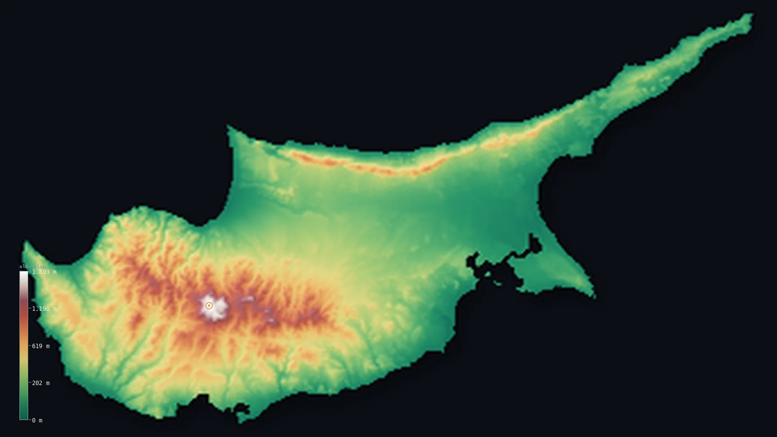
Cyprus’s highest point is Mount Olympus (Chionistra) at 6,404 ft (1,952 m); its lowest is Mediterranean Sea at 0 ft (0 m); the mean elevation is 994 ft (303 m).
Cyprus is a Mediterranean island of two mismatched mountain ranges and a plain between them. Most of it is low — the broad central Mesaoria plain and the coastal lowlands that ring the island — so half of Cyprus lies below about 682 ft (208 m). But the great dome of the Troodos massif fills the centre and southwest, covering about a third of the island and rising to Mount Olympus (also called Chionistra) at 6,404 ft (1,952 m) — snow-covered each winter, and not to be confused with the Greek Mount Olympus. Along the north coast runs the narrow Kyrenia Range, much lower, reaching only about 1,024 m.
- Highest point📚
- 6,404 ft1,952 m
- Cyprus's highest point is Mount Olympus — also called Chionistra ('snow dome') — at 6,404 ft (1,952 m), the culminating peak of the Troodos massif in the southwest. It is not the Greek Mount Olympus; this is the Cypriot one, built of uplifted ancient ocean crust, snow-covered from mid-January to mid-March and holding the island's only ski runs.
- Lowest point📚
- 0 ft0 m
- Cyprus's lowest point is sea level, along the Mediterranean coast that rings the island. From the shore the land rises gently across the coastal lowlands and the central Mesaoria plain, and steeply into the two mountain ranges.
- Mean elevation⚙
- 994 ft303 m
- Computed from the GLO-30 model, Cyprus's mean elevation is 994 ft (303 m) — a moderate figure, lifted by the great Troodos massif that covers about a third of the island. Half of Cyprus lies below about 682 ft (208 m), on the low Mesaoria plain and the coastal lowlands; only the Troodos, and the lower Kyrenia Range, rise high.
- Median elevation⚙
- 682 ft208 m
- Half of Cyprus lies below about 682 ft (208 m) — the low central Mesaoria plain and the coastal lowlands that ring the island. The Troodos massif in the southwest (rising to Mount Olympus) and the narrow Kyrenia Range along the north coast are the high ground that lifts the average above this typical level.
- Elevation range📚
- 6,404 ft1,952 m
- From the Mediterranean shore to the summit of Mount Olympus at 1,952 m, Cyprus's terrain spans about 6,404 ft — from warm coast up to a peak that holds snow and ski runs each winter, all on one Mediterranean island.
- Above 1,000 m (3,281 ft)⚙
- 4%
- About 4% of Cyprus rises above 1,000 m (3,281 ft) — almost all of it the high dome of the Troodos massif in the centre and southwest, around Mount Olympus. The Mesaoria plain, the coasts, and the lower Kyrenia Range lie below.
- Official area📚
- 3,572 mi²9,251 km²
- Cyprus covers about 3,572 sq mi (9,251 sq km) — the third-largest island in the Mediterranean, after Sicily and Sardinia, shaped by two mountain ranges (the Troodos massif and the narrow Kyrenia Range) enclosing the central Mesaoria plain.
- Forest cover📚
- 18.7%
- Under a fifth of Cyprus is forested — about 19%, mostly pine with the endemic golden oak and Cyprus cedar on the wetter Troodos slopes, while the low Mesaoria plain is open farmland.
Highest and lowest points
Cyprus's highest point is Mount Olympus, also called Chionistra ('snow dome'), at 6,404 ft (1,952 m) — the culminating peak of the Troodos massif near Platres in the southwest. It is not the famous Greek Mount Olympus; the two simply share a name. Built of ophiolite — uplifted ancient ocean crust, one of the world's most complete such sequences — it carries a radar station and the island's only ski runs, and snow lies on it from mid-January to mid-March while the coast below stays mild. From the Troodos dome the land falls away in every direction: to the Mesaoria plain in the north and east, and to the coastal lowlands and the sea.
source ↗Cyprus's lowest ground is its Mediterranean coastline, at sea level, ringing the island with beaches, low cliffs and coastal plains. Inland the land rises gently to the broad central Mesaoria plain — a low, tawny farm belt running west to east across the island, past the capital Nicosia, crossed by seasonal rivers that flow only after winter rain. From the plain the land climbs into two very different ranges: the great Troodos massif in the centre and southwest, a dome of uplifted ocean crust covering about a third of the island and rising to Mount Olympus (1,952 m, the highest point), with the island's densest forests and only ski runs; and, along the north coast, the narrow Kyrenia Range (the Pentadaktylos), a limestone ridge reaching only about 1,024 m, often crowned by medieval castles. The elevation shown here covers the whole island of Cyprus.
source ↗Cyprus at a glance
Mount Olympus (1,952 m) is high enough to hold snow from mid-January to mid-March and run the only ski lifts in Cyprus — its Greek name Chionistra means 'snow dome' — even though the rest of the island has a hot Mediterranean climate.
source ↗The Troodos massif is a slab of ancient ocean crust pushed above the sea — one of the world's most complete and studied ophiolite sequences, exposing rock that formed thousands of metres beneath an ancient seabed.
source ↗Those same Troodos rocks made Cyprus a copper powerhouse of antiquity, supplying the metal across the Mediterranean for centuries.
source ↗Cyprus's two mountain ranges are wildly mismatched — the Troodos dome rises to 1,952 m, while the narrow northern Kyrenia Range tops out at only about 1,024 m.
source ↗The island has been divided since 1974, with a United Nations buffer zone running across the Mesaoria plain through Nicosia; this page shows the elevation of the whole island of Cyprus.
source ↗Cyprus is the third-largest island in the Mediterranean, after Sicily and Sardinia.
source ↗
Elevation profile of Cyprus
The largest share of land, 49%, falls in the 0–200 m band, and 79% of the territory lies below 500 m (1,640 ft).
- below 500 m (1,640 ft)79%
- 500–1,000 m17%
- 1,000–2,000 m4%
Highest peaks of Cyprus
| Peak | Elevation | Range | Note |
|---|---|---|---|
| Mount Olympus (Chionistra)↗ | 6,404 ft1,952 m | Troodos Mountains | Highest point of Cyprus, the central dome of the Troodos massif; site of the island's ski runs. |
| Madari↗ | 5,292 ft1,613 m | Troodos Mountains (eastern) | A high peak on the eastern Troodos ridge, with a fire lookout and panoramic ridge trails. |
| Kyparissovouno↗ | 3,360 ft1,024 m | Kyrenia Range (Pentadaktylos) | The highest point of the narrow Kyrenia Range along the north coast — far lower than the Troodos. |
Cyprus: the Troodos massif, the Mesaoria plain, and the Kyrenia Range and coasts
The Troodos massif — centre and southwest
The centre and southwest are filled by the Troodos massif — a huge dome of ophiolite (uplifted ancient sea floor) covering about a third of Cyprus. It rises to Mount Olympus / Chionistra (1,952 m), holds the island's only year-round streams and densest forests of pine, cedar and golden oak, and casts a rain shadow over the rest of the island.
The Mesaoria plain — the centre
Between the two ranges lies the Mesaoria, a broad low plain running roughly west to east across the island, past the capital Nicosia to Famagusta Bay. It is the agricultural heart of Cyprus — dry and tawny in summer, green in winter — crossed by seasonal rivers that flow only after rain.
The Kyrenia Range and the coasts
Along the north coast runs the narrow Kyrenia Range (the Pentadaktylos, 'five-finger'), a limestone ridge reaching only about 1,024 m — far lower than the Troodos — often crowned by medieval castles. Elsewhere the mountains step down through foothills to the coastal plains and beaches that ring the island.
How to read this map
Color shows elevation; the raised relief shows real terrain. On this map Cyprus reads as a big high dome in the southwest — the Troodos massif, browns and whites rising to Mount Olympus — with a low tan band across the centre (the Mesaoria plain, past Nicosia) and a thin line of relief along the north coast (the Kyrenia Range), all ringed by coastal lowland. The elevation shown covers the whole island of Cyprus.
The 3D relief is the actual GLO-30 elevation data, exaggerated vertically so the Troodos dome, the low plain and the narrow northern ridge all show; the ×N relief slider controls how much. Tap anywhere to read that point's exact elevation.
City elevations in Cyprus
Cyprus's cities ring the coast and gather on the central plain — Nicosia, the capital, in the middle of the Mesaoria; Limassol, Larnaca and Paphos on the southern coasts; and Famagusta and Kyrenia on the east and north coasts. Most lie low, on the plain or by the sea, below the Troodos Mountains.
| City | Population | Elevation |
|---|---|---|
| Nicosiacapitalthe capital, in the middle of the Mesaoria plain, between the Troodos massif and the Kyrenia Range ↗ | 200,452 | 502 ft153 m |
| Limassolon the south coast, the main port and gateway to the Troodos Mountains rising inland ↗ | 154,000 | 82 ft25 m |
| Larnacaon the southeast coast, on Larnaca Bay ↗ | 72,000 | 30 ft9 m |
| Famagustaon the east coast, by Famagusta Bay ↗ | 42,526 | 36 ft11 m |
| Paphoson the southwest coast, below the western slopes of the Troodos ↗ | 35,961 | 253 ft77 m |
| Kyreniaon the north coast, below the narrow Kyrenia Range ↗ | 26,701 | 72 ft22 m |
| Mórfou | 24,070 | 154 ft47 m |
| Protaras | 20,230 | 36 ft11 m |
| Pérgamos | 15,000 | 269 ft82 m |
| Dáli | 12,350 | 728 ft222 m |
Elevation sampled at each city centre from the Copernicus GLO-30 model. Cities and population from GeoNames (CC-BY 4.0).
Cyprus in comparison
Cyprus's terrain rises 6,404 ft (1,952 m) from sea level to Mount Olympus (Chionistra) — about 22% of the height of Mount Everest, the world's highest point at 29,032 ft (8,849 m).
- Greece's mean elevation is 1,578 ft — 584 ft higher; its high point, Mount Olympus (Mytikas peak), reaches 9,573 ft (2,918 m), 3,169 ft above. Greece elevation map →
- Lebanon's mean elevation is 3,271 ft — 2,277 ft higher; its high point, Qurnat as Sawda, reaches 10,131 ft (3,088 m), 3,727 ft above. Lebanon elevation map →
- Malta's mean elevation is 261 ft — 733 ft lower; its high point, Ta' Dmejrek, reaches 830 ft (253 m), 5,574 ft below. Malta elevation map →
Frequently asked questions
What is the highest point in Cyprus?
- Mount Olympus, also called Chionistra, 6,404 ft (1,952 m), the central peak of the Troodos massif.
What is the average elevation of Cyprus?
- Computed from the Copernicus GLO-30 model, the area-weighted mean is 994 ft (303 m) — a moderate figure, lifted by the Troodos massif that covers about a third of the island. Half of Cyprus lies below about 682 ft (208 m), on the low Mesaoria plain and the coasts.
Can you ski in Cyprus?
- Yes — Mount Olympus in the Troodos holds enough snow from mid-January to mid-March to run the island's only ski lifts, a striking contrast with the Mediterranean coast below.
What are the mountain ranges of Cyprus?
- Two — the large Troodos massif (with Mount Olympus, 1,952 m) across the centre and southwest, and the narrow Kyrenia Range (Pentadaktylos, up to ~1,024 m) along the north coast.
What is the lowest point in Cyprus?
- Sea level, along the Mediterranean coast that rings the island.
What is the Mesaoria?
- The broad central plain between the Troodos and Kyrenia ranges, running west to east past Nicosia to Famagusta Bay — Cyprus's main farmland, crossed by seasonal rivers.
How big is Cyprus?
- About 9,251 km² — the third-largest island in the Mediterranean, after Sicily and Sardinia.
Is this a topographic, relief, contour, or elevation map of Cyprus?
- They describe the same thing — terrain height. This page renders the whole island's actual elevation surface in interactive 3D (a relief or topographic view) and reports the elevation statistics computed from it; a contour map shows the same data as lines of equal height.
About this map
The terrain is rendered from the Copernicus GLO-30 digital elevation model (ESA), masked to the CYP-ADM0 boundary from geoBoundaries (gbOpen). Elevation statistics are computed directly from the model; peak names and researched facts are sourced and cited. See the methodology for the full pipeline.
Our area-weighted mean, computed from the Copernicus GLO-30 model, is 994 ft (303 m); the figure commonly cited elsewhere is 299 ft (91 m) (CIA World Factbook). Cyprus is an island of two mismatched mountain ranges and a plain between them. Most of it is low — the broad central Mesaoria plain and the coastal lowlands that ring the island — so half of Cyprus lies below about 682 ft (208 m). But the great dome of the Troodos massif fills the centre and southwest, covering about a third of the island and rising to Mount Olympus (1,952 m), and the narrow Kyrenia Range runs along the north coast; these lift the average above the low plain, to a moderate mean rather than a low one. (The mean here is computed directly from the GLO-30 surface across the whole island, and runs well above a much lower figure sometimes cited elsewhere — hard to reconcile with an island a third of which is covered by mountains.)
Surveyed national figures: official area · forest cover · high point.
Rendered from Copernicus GLO-30 (ESA, 2021 release), boundaries from geoBoundaries. Generated 2026-06-22.