Malta Elevation Map — Topographic & 3D Terrain
Explore the terrain of Malta in interactive 3D, built from Copernicus GLO-30 satellite elevation data — a low limestone archipelago in the middle of the Mediterranean. Drag to rotate, scroll to zoom, and tap any point to read its elevation.
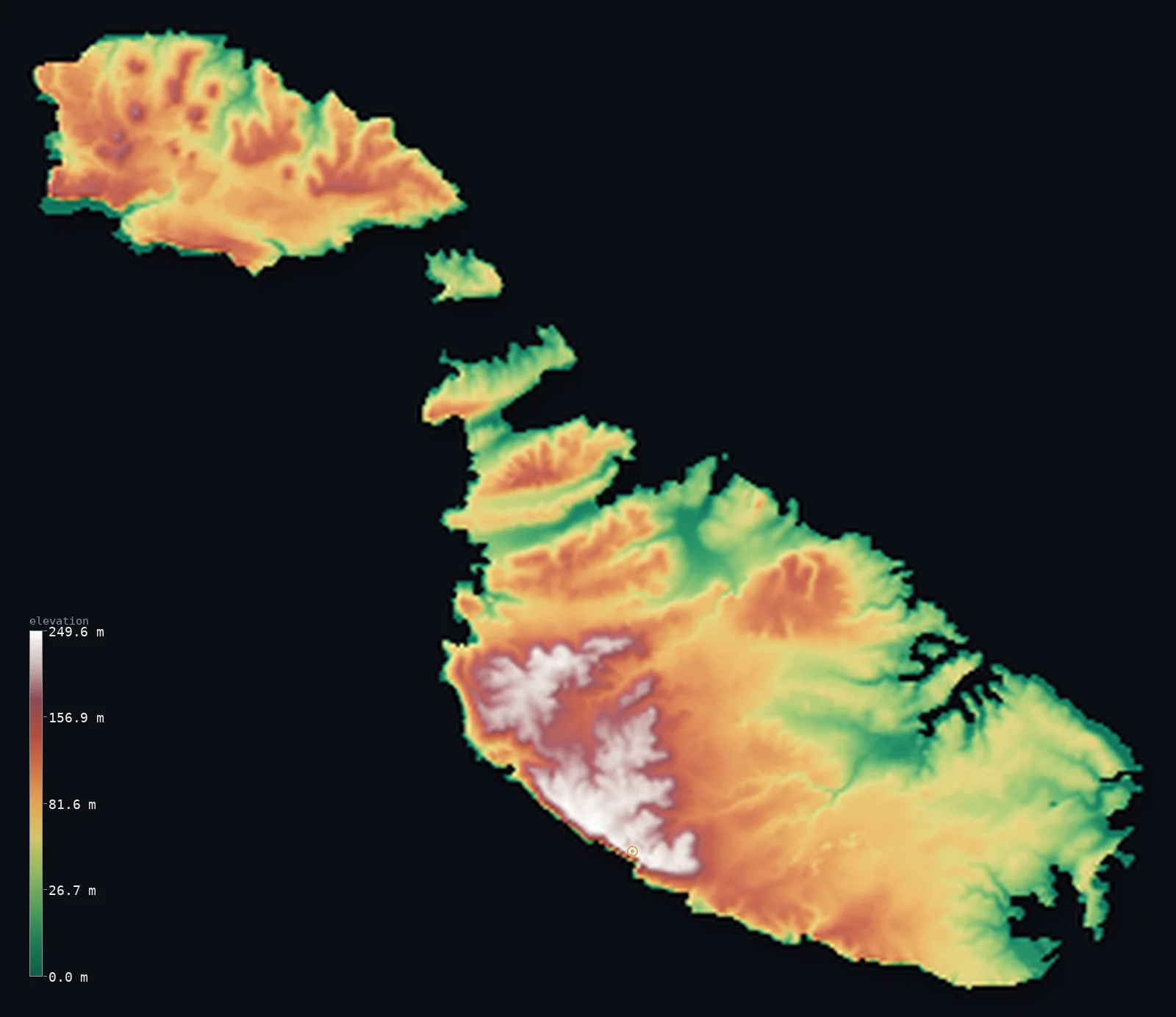
Malta’s highest point is Ta' Dmejrek at 830 ft (253 m); its lowest is Mediterranean Sea at 0 ft (0 m); the mean elevation is 261 ft (79.6 m).
Malta is a small, low archipelago of limestone in the central Mediterranean, between Sicily and North Africa. Its islands — Malta, Gozo, and Comino chief among them — are made of pale, layered rock, tilted so that they rise gently from low eastern shores to higher western cliffs. There are no mountains and no rivers of note: the highest point, Ta' Dmejrek near the Dingli Cliffs, is just 830 ft (253 m), on the western edge where the land drops sheer to the sea.
- Highest point📚
- 830 ft253 m
- Malta's highest point is Ta' Dmejrek at 830 ft (253 m), near the Dingli Cliffs on the southwestern coast of the main island — the top of the tilted limestone, where the islands reach their greatest height just before the land falls away in sheer cliffs to the Mediterranean. It is high ground only by the modest measure of a low archipelago.
- Lowest point📚
- 0 ft0 m
- Malta's lowest point is the Mediterranean Sea at sea level, around the coasts of the islands — a shoreline of bays, harbours, and low rocky inlets in the east, giving way to high cliffs in the west.
- Mean elevation⚙
- 261 ft79.6 m
- Computed from the GLO-30 model, Malta's mean elevation is 261 ft (79.6 m) — low, reflecting a small archipelago of tilted limestone: gently rising from low eastern shores to the western cliffs, with no mountains and little high ground anywhere.
- Median elevation⚙
- 247 ft75.2 m
- Half of Malta lies below about 247 ft (75 m) — a low figure that fits the islands' tilted form: much of the land is the lower, gently sloping eastern ground, with the higher western uplands and their cliffs a minority of the area.
- Elevation range📚
- 830 ft253 m
- Malta's terrain rises only about 830 ft from the Mediterranean to Ta' Dmejrek — a small range for a whole country, the tilted limestone climbing gently from the eastern shores to the western cliff-tops, with no mountains at all.
- Above 50 m (164 ft)⚙
- 66%
- About 66% of Malta lies above 164 ft (50 m) — the higher central and western ground of the main island and Gozo, rising toward the Dingli Cliffs. The lower ground is the eastern coast and its harbours; none of the country reaches even 300 m.
- Official area📚
- 122 mi²316 km²
- Malta covers only about 122 sq mi (316 sq km) — a small archipelago in the central Mediterranean between Sicily and North Africa, made up of the islands of Malta, Gozo, and Comino and several islets, all of low limestone.
- Forest cover📚
- 1.5%
- About 1.5% of Malta is forested — very little: the islands are dry, rocky, and among the most densely populated in the world, with garrigue scrub, low maquis, and small planted areas rather than natural forest. Water is scarce and the landscape bare and sun-struck.
Highest and lowest points
Malta's highest point is Ta' Dmejrek, 830 ft (253 m), near the Dingli Cliffs on the southwestern coast of the main island. It is not a peak but the high edge of the tilted limestone plateau: the islands are made of layered rock tilted up toward the southwest, so the land rises gently from the low eastern shores to this western rim, where it ends abruptly in the Dingli Cliffs falling to the sea. In a country whose highest ground is barely 250 m, it is the modest summit of a low, rocky archipelago.
source ↗Malta's lowest point is the Mediterranean at sea level, around the coasts of its islands. The shoreline is a study in the islands' tilt: in the east, low and indented, with the great natural harbours around Valletta that made Malta a strategic prize for centuries; in the west, high and sheer, where the tilted limestone is cut off by cliffs like those at Dingli, dropping straight to the sea. Between them the land slopes gently up from east to west.
source ↗Malta at a glance
Malta's highest point, Ta' Dmejrek (253 m), is not a peak but the flat top of a plateau - part of it is taken up by a limestone quarry.
source ↗The whole country is just 316 km2 across three inhabited islands, making it one of the smallest and most densely populated nations on Earth.
source ↗Malta has no permanent rivers or lakes - only dry valleys (wied) that flow briefly after winter storms - and relies on groundwater and desalination.
source ↗The islands are the high points of a submerged limestone land bridge that once linked Sicily to North Africa.
source ↗Tectonic tilting raised dramatic cliffs up to ~250 m on the south and southwest coasts while the northeast slopes gently to harbours and bays.
source ↗Though in Europe, Malta sits on the African tectonic plate, closer to Tunisia's latitude than to mainland Italy.
source ↗
Elevation profile of Malta
The largest share of land, 15%, falls in the 80–100 m band, and 100% of the territory lies below 500 m (1,640 ft).
- 0–10 m (0–33 ft)7%
- 10–50 m (33–164 ft)26%
- above 50 m (164 ft)66%
Highest peaks of Malta
Malta: the low eastern shores and the western cliffs
The low eastern shores and harbours
The eastern side of the Maltese islands is low — gently sloping limestone meeting the sea in bays, inlets, and the great natural harbours around Valletta and Marsaxlokk. This lower, more sheltered ground holds most of the population, cities, and ports of a densely settled country.
The western uplands and cliffs
Toward the west and southwest the tilted limestone rises to the islands' highest ground — the uplands around Ta' Dmejrek — and ends abruptly in high sea-cliffs such as the Dingli Cliffs, where the land drops sheer to the Mediterranean. Higher, barer, and wilder than the east, it is the islands' elevated rim.
How to read this map
Color shows elevation; the raised relief shows real terrain. On this map Malta reads as a scatter of low limestone islands — Malta, Gozo, and Comino — gently tilted, lower and greener on the eastern shores where the harbours are, rising to the higher brown ground and cliffs on the western edge around Ta' Dmejrek.
The 3D relief is the actual GLO-30 elevation data, exaggerated vertically so the gentle tilt and the western cliffs show; the ×N relief slider controls how much. Tap anywhere to read that point's exact elevation.
City elevations in Malta
Malta's towns cluster on the low eastern side of the main island around the harbours — Valletta, the capital, on its promontory between two harbours, with a dense conurbation around it — while hill towns like Mellieħa and Żebbuġ sit on the higher inland limestone. Most of the population lives low, near the sea.
| City | Population | Elevation |
|---|---|---|
| Mellieħaa hill town in the north of the main island, on higher ground above the bays ↗ | 11,389 | 430 ft131 m |
| Vallettacapitalthe capital, on a promontory between two natural harbours on the low eastern coast ↗ | 6,794 | 144 ft44 m |
| Żebbuġon the higher inland limestone of the main island, west of the harbour conurbation ↗ | 1,770 | 427 ft130 m |
Elevation sampled at each city centre from the Copernicus GLO-30 model. Cities and population from GeoNames (CC-BY 4.0).
Malta in comparison
Malta's terrain rises 830 ft (253 m) from sea level to Ta' Dmejrek — about 3% of the height of Mount Everest, the world's highest point at 29,032 ft (8,849 m).
- Italy's mean elevation is 1,814 ft — 1,553 ft higher; its high point, Monte Bianco (Mont Blanc), reaches 15,768 ft (4,806 m), 14,938 ft above. Italy elevation map →
- Cyprus's mean elevation is 994 ft — 733 ft higher; its high point, Mount Olympus (Chionistra), reaches 6,404 ft (1,952 m), 5,574 ft above. Cyprus elevation map →
- San Marino's mean elevation is 965 ft — 703 ft higher; its high point, Monte Titano, reaches 2,425 ft (739 m), 1,594 ft above. San Marino elevation map →
Frequently asked questions
What is the highest point in Malta?
- Ta' Dmejrek, 830 ft (253 m), near the Dingli Cliffs on the western coast of the main island — the high edge of the tilted limestone, where the land ends in sheer cliffs to the sea.
What is the lowest point in Malta?
- The Mediterranean Sea at sea level, around the coasts of the islands — low and harbour-lined in the east, high-cliffed in the west.
What is the average elevation of Malta?
- Computed from the Copernicus GLO-30 model, the area-weighted mean is 261 ft (79.6 m) — low, because Malta is a small archipelago of tilted limestone with no mountains, rising gently from eastern shores to western cliffs.
How many islands does Malta have?
- Three main inhabited islands — Malta, Gozo, and Comino — plus several small islets, all of low limestone, in the central Mediterranean.
Is Malta flat?
- Low, but gently tilted rather than flat — the limestone islands rise from low eastern shores to western cliffs around 250 m, with no mountains. The highest point, Ta' Dmejrek, is just 253 m.
Is this a topographic, relief, contour, or elevation map of Malta?
- They describe the same thing — terrain height. This page renders the country's actual elevation surface in interactive 3D and reports the statistics computed from it.
About this map
The terrain is rendered from the Copernicus GLO-30 digital elevation model (ESA), masked to the MLT-ADM0 boundary from geoBoundaries (gbOpen). Elevation statistics are computed directly from the model; peak names and researched facts are sourced and cited. See the methodology for the full pipeline.
This map renders 321 km² across 5 landmasses of Malta. One smaller outlying part — 0 km² in total — lies beyond the area shown here. Area statistics above count the full territory.
Our area-weighted mean, computed from the Copernicus GLO-30 model, is 261 ft (79.6 m); no authority publishes a mean elevation (no authoritative published mean). No standard reference publishes a mean elevation for Malta; the page reports the area-weighted figure computed from the Copernicus GLO-30 model. It is low, as befits a small archipelago of tilted limestone — rising gently from the low eastern shores to the western cliffs around Ta' Dmejrek, with no mountains anywhere.
Surveyed national figures: official area · forest cover · high point.
Rendered from Copernicus GLO-30 (ESA, 2021 release), boundaries from geoBoundaries. Generated 2026-07-09.