San Marino Elevation Map — Topographic & 3D Terrain
Explore the terrain of San Marino in interactive 3D, built from Copernicus GLO-30 satellite elevation data — a tiny country on a single limestone ridge above the Italian plain. Drag to rotate, scroll to zoom, and tap any point to read its elevation.
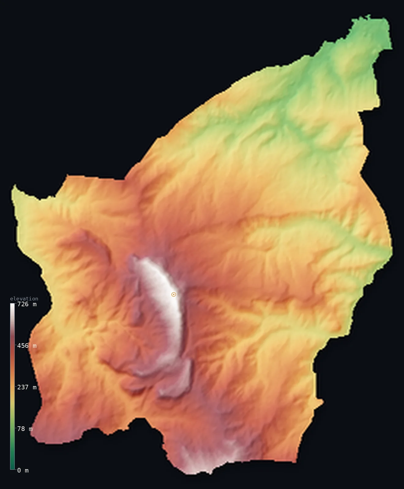
San Marino’s highest point is Monte Titano at 2,425 ft (739 m); its lowest is Torrente Ausa at 180 ft (55 m); the mean elevation is 965 ft (294 m).
San Marino is built around a single mountain ridge. One of the world's smallest and oldest republics, entirely surrounded by Italy near the Adriatic coast, it is defined by Monte Titano, a limestone crag rising 2,425 ft (739 m) straight out of the rolling Romagna countryside. From the ridge the land falls away on all sides into hills and valleys, down to about 180 ft (55 m) where the river Ausa leaves the country. The historic capital clings to the top of the crag.
- Highest point📚
- 2,425 ft739 m
- San Marino's highest point is Monte Titano at 2,425 ft (739 m) — the limestone ridge that is the heart and symbol of the country, rising abruptly from the surrounding Italian plain and hills. Its three summits, each once crowned with a fortress tower, dominate the tiny republic; the historic city of San Marino clings to the crest. The true high ground lies along this ridge, the country falling away from it on every side.
- Lowest point📚
- 180 ft55 m
- San Marino's lowest point is on the river Ausa at about 180 ft (55 m), where the stream leaves the country for Italy — the low end of a land that tilts down from the Monte Titano ridge into the hills and valleys around it.
- Mean elevation⚙
- 965 ft294 m
- Computed from the GLO-30 model, San Marino's mean elevation is 965 ft (294 m) — a moderate figure for so small a country, reflecting terrain that falls away from the high Monte Titano ridge through surrounding hills and valleys toward the Italian plain.
- Median elevation⚙
- 938 ft286 m
- Half of San Marino lies below about 938 ft (286 m) — well below the Monte Titano summit, because the country is not all ridge: the land falls from the high crag through a spread of hills and valleys, so much of it is middle-height hill country rather than the high ground of the ridge itself.
- Elevation range📚
- 2,244 ft684 m
- San Marino's terrain climbs about 2,244 ft from the river Ausa to the summit of Monte Titano — a striking range for so tiny a country, from the valley floors around it up to the limestone crag that rises abruptly at its heart.
- Official area📚
- 24 mi²61 km²
- San Marino covers only about 24 sq mi (61 sq km) — one of the smallest countries in the world, entirely surrounded by Italy near the Adriatic, built around the single dramatic ridge of Monte Titano rising from the surrounding hills.
- Forest cover📚
- 45%
- About 45% of San Marino is forested — woodland on the steeper slopes of Monte Titano and the surrounding hills, with the gentler ground farmed and settled; the ridge itself is rocky and crowned by the historic towers and town.
Highest and lowest points
San Marino's highest point is Monte Titano, 2,425 ft (739 m) — the limestone ridge that is the country's very reason for being. Rising abruptly from the rolling country near the Adriatic, its defensible crag was settled, by tradition, in the fourth century, and the republic grew up around and atop it. The ridge has three summits, each crowned by an ancient fortress tower — the Three Towers that are San Marino's emblem — and the historic capital city clings to the crest, with long views over the surrounding hills to the sea. The whole country falls away from this ridge on every side.
source ↗San Marino's lowest point is on the river Ausa, at about 180 ft (55 m), where the small stream flows out of the country into Italy toward the Adriatic. It marks the low edge of a country that is defined by height: from the valley floors around its borders, the land rises through hills to the great limestone ridge of Monte Titano at its centre. Even San Marino's low ground is hill country, tilting up toward the crag that is the country's heart.
source ↗San Marino at a glance
San Marino's whole country is dominated by a single ridge, Monte Titano (739 m), with the capital strung along its crest.
source ↗Monte Titano was once under the sea - its limestone holds Miocene fossils of fish, sharks and even a whale.
source ↗The three summits of Monte Titano are each crowned by one of the Three Towers, the emblem on San Marino's flag.
source ↗San Marino is landlocked and completely surrounded by Italy, yet the Adriatic Sea is only about 10 km from Monte Titano.
source ↗It is one of the smallest countries in the world, at about 61 km2.
source ↗
Elevation profile of San Marino
The largest share of land, 14%, falls in the 200–250 m band, and 94% of the territory lies below 500 m (1,640 ft).
- below 500 m (1,640 ft)94%
- 500–1,000 m6%
Highest peaks of San Marino
| Peak | Elevation | Range | Note |
|---|---|---|---|
| Monte Titano↗ | 2,425 ft739 m | Apennines | Highest point of San Marino, a limestone ridge crowned by the Three Towers, with the capital along its crest. |
San Marino: Monte Titano and the hills around it
Monte Titano (the ridge)
The heart of San Marino is Monte Titano — a limestone ridge rising 739 m abruptly from the surrounding country, with three summits crowned by ancient towers and the historic capital clinging to its crest. The country's highest and most dramatic ground, it is the crag around which the republic was built.
The surrounding hills and valleys
Away from the central ridge, San Marino is a spread of hills and valleys falling toward the Italian plain — farmed slopes, small valleys, and the streams that drain the country, down to the river Ausa at its lowest. Middle-height hill country, tilting up toward Monte Titano at the centre.
How to read this map
Color shows elevation; the raised relief shows real terrain. On this map San Marino reads as a single dramatic ridge and its surroundings — the brown-and-white crag of Monte Titano rising abruptly at the country's heart, with the greener hills and valleys falling away from it on every side toward the Italian plain.
The 3D relief is the actual GLO-30 elevation data, exaggerated vertically so the ridge stands out from the hills around it; the ×N relief slider controls how much. Tap anywhere to read that point's exact elevation.
City elevations in San Marino
San Marino's settlements sit on and around Monte Titano — the historic capital, the City of San Marino, high on the ridge crest, with the larger modern towns spread on the lower slopes and valley floors below toward the Italian border.
| City | Population | Elevation |
|---|---|---|
| San Marinocapitalthe historic capital, clinging to the crest of Monte Titano — the highest of the country's settlements, on the ridge itself ↗ | 4,500 | 2,096 ft639 m |
Elevation sampled at each city centre from the Copernicus GLO-30 model. Cities and population from GeoNames (CC-BY 4.0).
San Marino in comparison
San Marino's terrain rises 2,244 ft (684 m) from Torrente Ausa (180 ft (55 m)) to Monte Titano — about 8% of the height of Mount Everest, the world's highest point at 29,032 ft (8,849 m).
- Italy's mean elevation is 1,814 ft — 850 ft higher; its high point, Monte Bianco (Mont Blanc), reaches 15,768 ft (4,806 m), 13,343 ft above. Italy elevation map →
- Monaco's mean elevation is 149 ft — 815 ft lower; its high point, Chemin des Revoires (Mont Agel slope), reaches 528 ft (161 m), 1,896 ft below. Monaco elevation map →
Frequently asked questions
What is the highest point in San Marino?
- Monte Titano, 2,425 ft (739 m) — the limestone ridge at the country's heart, its three tower-crowned summits dominating the tiny republic, with the capital on the crest.
What is the lowest point in San Marino?
- The river Ausa at about 180 ft (55 m), where it leaves the country for Italy — the low edge of a land that rises to the Monte Titano ridge.
What is the average elevation of San Marino?
- Computed from the Copernicus GLO-30 model, the area-weighted mean is 965 ft (294 m) — moderate, as the land falls from the high Monte Titano ridge through surrounding hills toward the Italian plain.
What is Monte Titano?
- The limestone ridge that San Marino is built around — rising 739 m abruptly from the Italian countryside, with three tower-crowned summits and the historic capital on its crest. It is the country's symbol and reason for being.
Is San Marino mountainous?
- It is built around one mountain — Monte Titano, 739 m — with the rest of the country a spread of hills and valleys falling away from the central ridge. Hilly throughout, with no truly flat ground.
Is this a topographic, relief, contour, or elevation map of San Marino?
- They describe the same thing — terrain height. This page renders the country's actual elevation surface in interactive 3D and reports the statistics computed from it.
About this map
The terrain is rendered from the Copernicus GLO-30 digital elevation model (ESA), masked to the SMR-ADM0 boundary from geoBoundaries (gbOpen). Elevation statistics are computed directly from the model; peak names and researched facts are sourced and cited. See the methodology for the full pipeline.
Our area-weighted mean, computed from the Copernicus GLO-30 model, is 965 ft (294 m); no authority publishes a mean elevation (No authoritative published mean elevation). No standard reference publishes a mean elevation for San Marino; the page reports the area-weighted figure computed from the Copernicus GLO-30 model. It is moderate, as the land falls from the high Monte Titano ridge through the surrounding hills and valleys toward the Italian plain — hill country throughout, with the crag its one high point.
Surveyed national figures: official area · forest cover · high point.
Rendered from Copernicus GLO-30 (ESA, 2021 release), boundaries from geoBoundaries. Generated 2026-06-26.
Bordering countries · 1
San Marino shares a land border with these countries — open any one to compare its terrain and highest point.