Monaco Elevation Map — Topographic & 3D Terrain
Explore the terrain of Monaco in interactive 3D, built from Copernicus GLO-30 satellite elevation data — a city-state built on a steep Mediterranean slope, the second-smallest country on Earth. Drag to rotate, scroll to zoom, and tap any point to read its elevation.
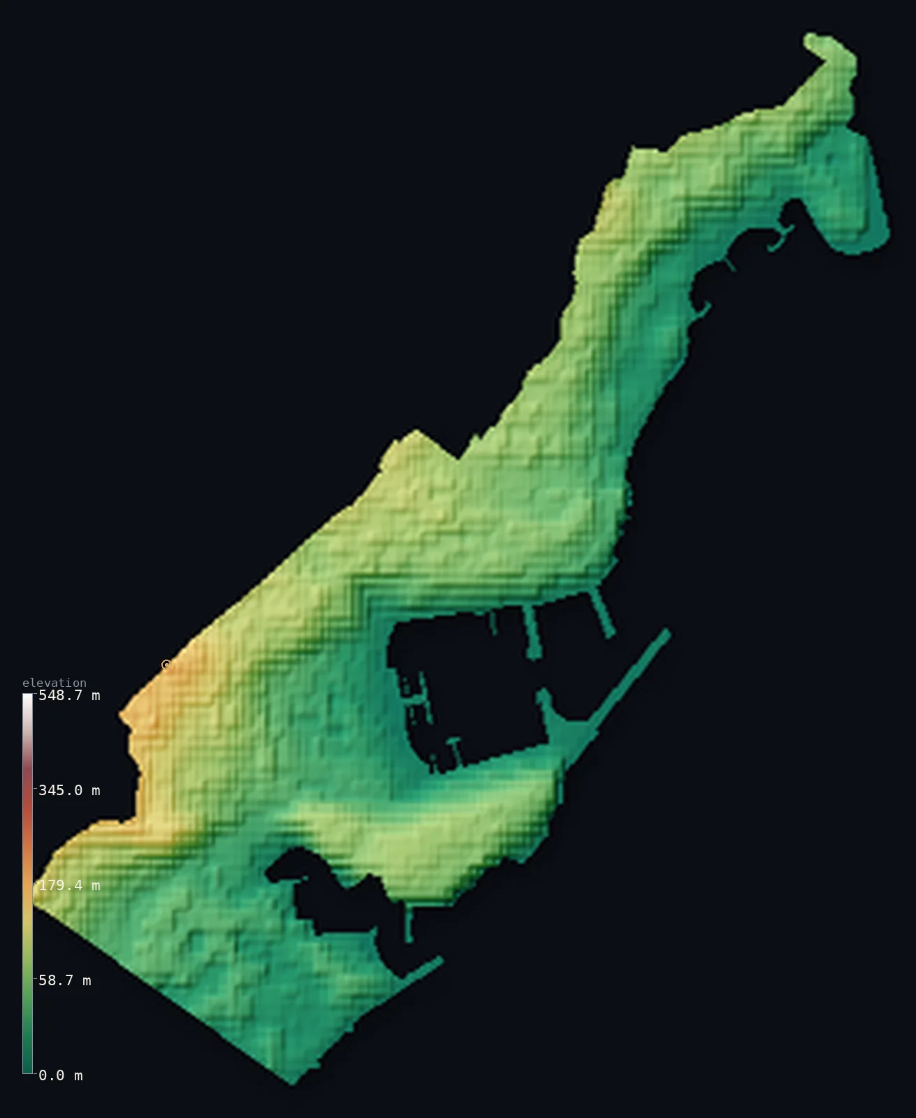
Monaco’s highest point is Chemin des Revoires (Mont Agel slope) at 528 ft (161 m); its lowest is Mediterranean Sea at 0 ft (0 m); the mean elevation is 149 ft (45.5 m).
Monaco is a city on a mountainside by the sea. The second-smallest country in the world, barely two square kilometres, it is built up a steep slope of the French Riviera where the foothills of the Maritime Alps drop straight to the Mediterranean. From the harbour and the sea at zero, the ground rises sharply inland — terraced, built-over, and densely packed — to about 528 ft (161 m) at its highest, on the Chemin des Révoires below the French border. Nearly every part of the country is developed; the terrain is a staircase of streets and buildings climbing the hillside.
- Highest point📚
- 528 ft161 m
- Monaco's highest point is on the Chemin des Révoires at about 528 ft (161 m), on the slopes of Mont Agel below the French border — the top of the steep hillside the city climbs. The true summit of Mont Agel itself rises higher just across the border in France; within Monaco, the Chemin des Révoires is the highest ground on a slope that is almost entirely built upon.
- Lowest point📚
- 0 ft0 m
- Monaco's lowest point is the Mediterranean Sea at sea level, along its short, intensely developed coast of harbours, marinas, and sea walls — some of the country's land itself reclaimed from the sea.
- Mean elevation⚙
- 149 ft45.5 m
- Computed from the GLO-30 model, Monaco's mean elevation is 149 ft (45.5 m) — low, but the figure hides the character of the place: Monaco is not flat but steep, a small country rising sharply from the sea up a Riviera hillside, its modest average the result of a low base climbing quickly to about 160 m.
- Median elevation⚙
- 128 ft39.1 m
- Half of Monaco lies below about 128 ft (39 m) — reflecting how much of the country is the lower, seaward part of the slope, near the harbours and the coast, with the ground rising steeply behind to the high point on the Chemin des Révoires.
- Elevation range📚
- 528 ft161 m
- Monaco climbs about 528 ft from the sea to the Chemin des Révoires — not a wide range, but a steep one: the ground gains 160 m up the Riviera hillside over a very short horizontal distance, the defining fact of a city built on a slope.
- Above 50 m (164 ft)⚙
- 43%
- About 43% of Monaco lies above 164 ft (50 m) — the upper, inland part of the slope, climbing from the harbours near the sea to the high ground on the Chemin des Révoires. The lower, seaward part of the country is the developed coast.
- Official area📚
- 1 mi²2 km²
- Monaco covers only about 0.8 sq mi (2 sq km) — the second-smallest country in the world after Vatican City, a city-state on the French Riviera built up a steep Mediterranean slope, some of its land reclaimed from the sea.
- Forest cover📚
- 0%
- Monaco is almost entirely built up — one of the most densely developed places on Earth, with little vegetated or forested land; the slope is covered by the city itself, terraced and dense, with gardens rather than wild ground.
Highest and lowest points
Monaco's highest point is a spot on the Chemin des Révoires, in the Les Révoires district, at about 528 ft (161 m) — the highest the ground rises within the country, on the lower slopes of Mont Agel below the French border. Mont Agel's actual summit is higher, but lies just across the frontier in France; Monaco's own high point is this point on its steep, built-up hillside. In a country barely two square kilometres in size, the land still climbs 160 m from the sea — a measure of how steep the Riviera slope beneath the city is.
source ↗Monaco's lowest point is the Mediterranean at sea level, along a short coast that is one of the most developed shorelines anywhere — harbours, marinas, sea walls, and land reclaimed from the sea to extend the tiny country outward. The famous harbour of Port Hercule, the coastal Grand Prix circuit, and the districts built on reclaimed ground all sit at this low, seaward edge, from which the city climbs steeply inland up the hillside.
source ↗Chemin des Revoires (Mont Agel slope)'s surveyed summit sits just outside the generalized Monaco boundary, so the highest fully in-territory land pixel in the model is 537 ft (164 m). The headline figure above is the surveyed elevation of the recognised national high point.
Monaco at a glance
Monaco is the world's second-smallest country (after Vatican City) at about 2 km2, and the most densely populated.
source ↗Its highest point is just 161 m, on an unmarked spot of footpath at the French border - not a peak, but the upper edge of its steep slope.
source ↗The mountain it sits on, Mont Agel (1,148 m), has its summit entirely inside France - Monaco only reaches the lower slope.
source ↗Monaco has expanded its land area by about a fifth through land reclamation from the sea, most visibly the Fontvieille district.
source ↗The whole country is barely 1.7 km at its widest and narrows to about 350 m, squeezed between the mountains and the sea.
source ↗Monaco-Ville sits on Le Rocher, a promontory about 60 m high that juts into the Mediterranean and holds the Prince's Palace.
source ↗
Elevation profile of Monaco
The largest share of land, 31%, falls in the 0–20 m band, and 100% of the territory lies below 500 m (1,640 ft).
- 0–10 m (0–33 ft)18%
- 10–50 m (33–164 ft)39%
- above 50 m (164 ft)43%
Highest peaks of Monaco
| Peak | Elevation | Range | Note |
|---|---|---|---|
| Chemin des Revoires (Mont Agel slope)↗ | 528 ft161 m | Mont Agel slope (French border, northwest) | Highest point of Monaco, an unmarked spot on a footpath where the city-state meets France. |
| Le Rocher (Monaco-Ville promontory)↗ | 197 ft60 m | Monaco-Ville (coast) | The rocky headland carrying the old town and the Prince's Palace, about 60 m above the sea. |
Monaco: the coast and harbours, and the hillside above
The coast and harbours (low)
Monaco's seaward edge is its low ground — the Mediterranean coast of harbours (Port Hercule), marinas, and sea walls, including the Fontvieille district built on land reclaimed from the sea. This developed shoreline, at and just above sea level, is where the country meets the water.
The hillside (rising inland)
Behind the coast the country climbs steeply up the Riviera hillside — a dense staircase of terraced districts, streets, and buildings rising to the high point on the Chemin des Révoires near the French border. Monaco is built up this slope, its terrain a steep, developed hillside from sea to summit.
How to read this map
Color shows elevation; the raised relief shows real terrain. On this map Monaco reads as a steep little slope by the sea — low at the coast and harbours in blues and greens, rising sharply inland through the built-up hillside to its high point near the French border. At barely two square kilometres, it is the smallest territory on this map, and the relief shows the steep Riviera slope the whole city is built upon.
The 3D relief is the actual GLO-30 elevation data, exaggerated vertically; the ×N relief slider controls how much. Tap anywhere to read that point's exact elevation.
City elevations in Monaco
Monaco is a single city-state — the whole country is one built-up area rising from the harbours and coast up the steep Riviera slope, with no separate towns, only its traditional quartiers strung along the shore and hillside.
| City | Population | Elevation |
|---|---|---|
| Monacocapitalthe city-state itself — the whole country is a single continuous urban area climbing the slope, so this sample point sits partway up the built-up hillside ↗ | 32,965 | 174 ft53 m |
Elevation sampled at each city centre from the Copernicus GLO-30 model. Cities and population from GeoNames (CC-BY 4.0).
Monaco in comparison
Monaco's terrain rises 528 ft (161 m) from sea level to Chemin des Revoires (Mont Agel slope) — about 2% of the height of Mount Everest, the world's highest point at 29,032 ft (8,849 m).
- France's mean elevation is 1,122 ft — 973 ft higher; its high point, Mont Blanc, reaches 15,768 ft (4,806 m), 15,240 ft above. France elevation map →
- San Marino's mean elevation is 965 ft — 815 ft higher; its high point, Monte Titano, reaches 2,425 ft (739 m), 1,896 ft above. San Marino elevation map →
- Liechtenstein's mean elevation is 3,579 ft — 3,430 ft higher; its high point, Grauspitz (Vorder-Grauspitz), reaches 8,527 ft (2,599 m), 7,999 ft above. Liechtenstein elevation map →
Frequently asked questions
What is the highest point in Monaco?
- A point on the Chemin des Révoires, about 528 ft (161 m), on the slopes of Mont Agel below the French border — the top of the hillside the city climbs. Mont Agel's summit itself is just across the border in France.
What is the lowest point in Monaco?
- The Mediterranean Sea at sea level, along its short, intensely developed coast of harbours and reclaimed land.
What is the average elevation of Monaco?
- Computed from the Copernicus GLO-30 model, the area-weighted mean is 149 ft (45.5 m) — low, though Monaco is steep rather than flat, rising sharply from the sea up a Riviera hillside to about 160 m.
How big is Monaco?
- About two square kilometres — the second-smallest country in the world after Vatican City, a city-state on the French Riviera, some of its land reclaimed from the sea.
Is Monaco flat?
- No — though low, it is steep: the ground climbs about 160 m from the harbour to the high point in a very short distance, up the Riviera hillside the whole city is built on.
Is this a topographic, relief, contour, or elevation map of Monaco?
- They describe the same thing — terrain height. This page renders the country's actual elevation surface in interactive 3D and reports the statistics computed from it.
About this map
The terrain is rendered from the Copernicus GLO-30 digital elevation model (ESA), masked to the MCO-ADM0 boundary from geoBoundaries (gbOpen). Elevation statistics are computed directly from the model; peak names and researched facts are sourced and cited. See the methodology for the full pipeline.
Our area-weighted mean, computed from the Copernicus GLO-30 model, is 149 ft (45.5 m); no authority publishes a mean elevation (no authoritative published mean). No standard reference publishes a mean elevation for Monaco — unsurprising for a country barely two square kilometres in size; the page reports the area-weighted figure computed from the Copernicus GLO-30 model. It is low, but Monaco is steep rather than flat: a low coastal base climbing quickly to about 160 m up the Riviera slope.
Surveyed national figures: official area · forest cover · high point.
Rendered from Copernicus GLO-30 (ESA, 2021 release), boundaries from geoBoundaries. Generated 2026-06-24.
Bordering countries · 1
Monaco shares a land border with these countries — open any one to compare its terrain and highest point.