Laos Elevation Map — Topographic & 3D Terrain
Explore the terrain of Laos in interactive 3D, built from Copernicus GLO-30 satellite elevation data — a landlocked, mountainous country strung along the Mekong in the heart of Southeast Asia. Drag to rotate, scroll to zoom, and tap any point to read its elevation.
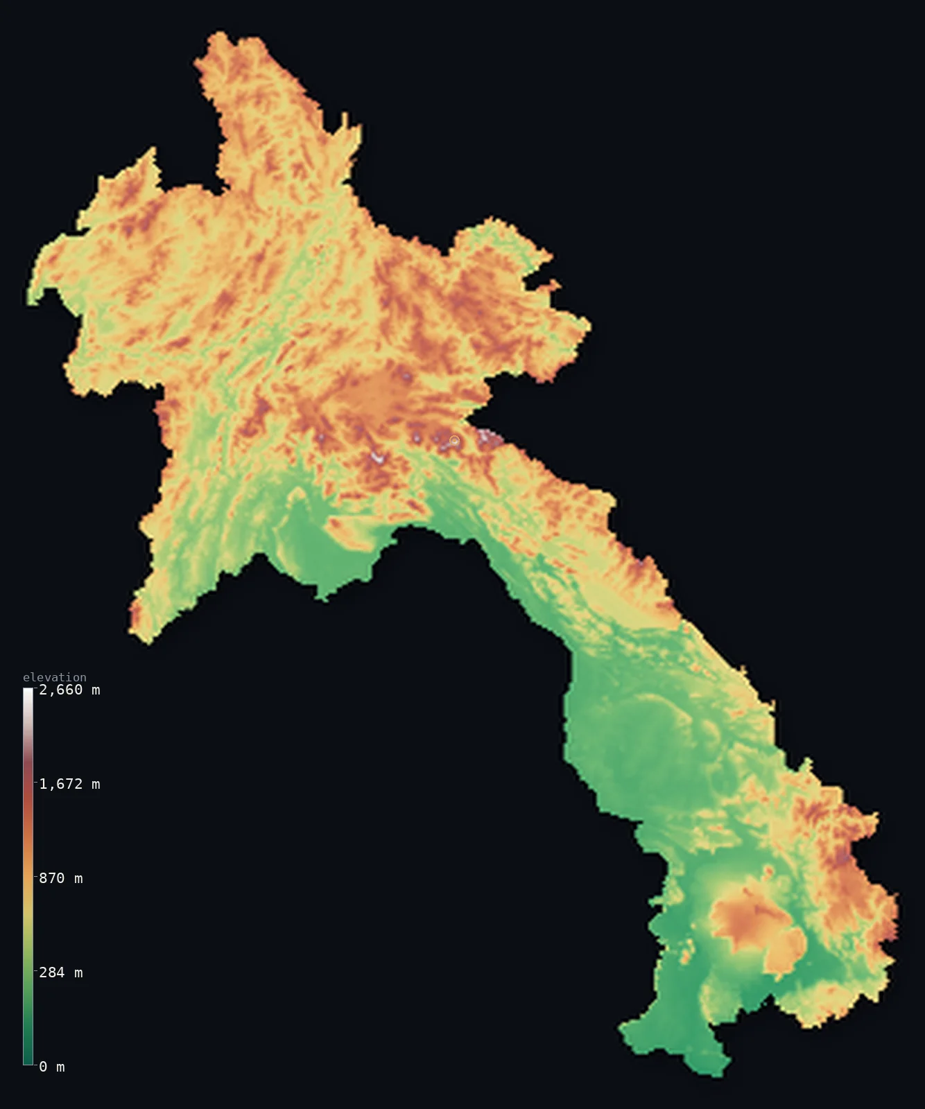
Laos’s highest point is Phou Bia at 9,249 ft (2,819 m); its lowest is Mekong River at 230 ft (70 m); the mean elevation is 2,188 ft (667 m).
Laos is a landlocked, mountainous country in the heart of Southeast Asia. Rugged forested highlands cover most of it — the Annamite Range along the eastern border with Vietnam, and a tangle of mountains and plateaus across the north — while the great river Mekong runs down its western side, forming much of the border with Thailand and gathering the lowlands where most people live. The highest point is Phou Bia, 9,249 ft (2,819 m), in the north-central highlands. It is the only landlocked country in Southeast Asia.
- Highest point📚
- 9,249 ft2,819 m
- Laos's highest point is Phou Bia at 9,249 ft (2,819 m), rising from the Xiangkhoang Plateau in the north-central part of the country — the highest of the mountains and plateaus that fill northern Laos. It stands in rugged, forested highland country, the roof of a nation that is mostly mountain.
- Lowest point📚
- 230 ft70 m
- Laos's lowest point is on the Mekong River where it leaves the country in the far south, at about 230 ft (70 m) — the low end of the great river that runs the length of Laos, gathering its lowlands as it goes toward Cambodia.
- Mean elevation⚙
- 2,188 ft667 m
- Computed from the GLO-30 model, Laos's mean elevation is 2,188 ft (667 m) — a moderate figure for a country that is mostly mountain and plateau: rugged forested highlands cover the north and the eastern border, with lower ground only along the Mekong and its tributary valleys.
- Median elevation⚙
- 2,116 ft645 m
- Half of Laos lies below about 2,116 ft (645 m) — the mountains cover most of the land, but the broad Mekong lowlands and river valleys balance them, pulling the midpoint down to hill-and-valley height rather than the level of the ranges themselves.
- Elevation range📚
- 9,019 ft2,749 m
- From the Mekong at 70 m to the summit of Phou Bia at 2,819 m, Laos's terrain climbs about 9,020 ft — from the great river's lowlands up into the forested highlands of the north, the country's dominant terrain.
- Above 1,000 m (3,281 ft)⚙
- 22%
- About 22% of Laos rises above 1,000 m (3,281 ft) — the highlands and plateaus of the north and the Annamite Range along the Vietnamese border, up to the highest ridges around Phou Bia. The lower ground follows the Mekong and its tributaries.
- Official area📚
- 91,429 mi²236,800 km²
- Laos covers about 91,400 sq mi (236,800 sq km) — a landlocked country in mainland Southeast Asia, mostly mountainous, strung along the Mekong River, bordered by China, Vietnam, Cambodia, Thailand, and Myanmar.
- Forest cover📚
- 71.5%
- About 72% of Laos is forested — one of the more heavily forested countries in the region, with dense tropical and monsoon forest cloaking the mountains and highlands, though the lowland valleys are farmed, above all for rice.
Highest and lowest points
Laos's highest point is Phou Bia, 9,249 ft (2,819 m), rising from the Xiangkhoang Plateau in the north-central highlands. It is the highest summit of the mountains that fill northern Laos — a region of forested ranges, high plateaus (including the Plain of Jars nearby), and deep valleys. Phou Bia itself is a forested peak, the high point of a country that is mostly rugged upland, with the lowlands confined to the Mekong and its tributaries.
source ↗Laos's lowest point is on the Mekong River where it flows out of the country in the far south, toward Cambodia, at about 230 ft (70 m) above sea level. The Mekong is the artery of Laos: it runs the length of the country down its western side, forms much of the border with Thailand, and gathers along its course the lowland plains — around Vientiane, Savannakhet, and the south — where most of the population lives and most of the rice is grown. Landlocked Laos has no coast; its waters, and much of its life, follow the Mekong south.
source ↗Laos at a glance
Laos is the only landlocked country in Southeast Asia, and the Mekong River - which forms much of its western border - is its main transport artery.
source ↗More than two-thirds of Laos is covered by forest, among the highest forest cover of any country in Southeast Asia.
source ↗Phou Bia (2,819 m) is rarely climbed - it sits in a restricted military area scattered with unexploded ordnance from the Indochina wars.
source ↗The Khone Falls, where the Mekong drops on its way out of southern Laos, block boats from reaching the sea and are among the widest waterfalls in the world.
source ↗The Xiangkhoang Plateau holds the Plain of Jars, an archaeological landscape of thousands of giant stone jars of uncertain origin.
source ↗The Bolaven Plateau in the south, raised by ancient volcanic basalt flows, is Laos's prime coffee-growing region.
source ↗
Elevation profile of Laos
The largest share of land, 17%, falls in the 600–800 m band, and 62% of the territory lies above 500 m (1,640 ft).
- below 500 m (1,640 ft)38%
- 500–1,000 m40%
- 1,000–2,000 m22%
- above 2,000 m (6,562 ft)<1%
Highest peaks of Laos
| Peak | Elevation | Range | Note |
|---|---|---|---|
| Phou Bia↗ | 9,249 ft2,819 m | Xiangkhoang Plateau / Annamite Range (north-central) | Highest point of Laos, a granite massif on the Xiangkhoang Plateau south of the Plain of Jars. |
| Phu Xai Lai Leng↗ | 8,924 ft2,720 m | Annamite Range (Laos-Vietnam border, northeast) | A high peak of the Annamite Range, on the border with Vietnam. |
| Bolaven Plateau (high ground)↗ | 4,429 ft1,350 m | Bolaven Plateau (south) | A broad basaltic plateau rising about 1,000-1,350 m above the southern Mekong lowlands - volcanic upland famous for coffee, not a single peak. |
Laos: the northern highlands, the Annamite border, and the Mekong lowlands
The northern highlands
Northern Laos is a tangle of mountains and plateaus — rugged, forested highland country cut by deep river valleys, holding the Xiangkhoang Plateau, Phou Bia (the country's high point), and the Plain of Jars. The highest and most rugged part of the country, sparsely peopled and heavily wooded.
The Annamite Range (the eastern border)
Along the eastern border with Vietnam runs the Annamite Range — the long chain of forested mountains that divides Laos from the Vietnamese coast, forming much of the frontier. Rugged, wet, and densely forested, it walls the country's eastern edge.
The Mekong lowlands (the west and south)
Down the western side of Laos and through the south run the lowlands of the Mekong and its tributaries — the river plains around Vientiane, Savannakhet, and the far south, where the land is lower, flatter, and farmed for rice. These valleys, following the great river, hold most of the country's people.
How to read this map
Color shows elevation; the raised relief shows real terrain. On this map Laos reads as a mostly mountainous country — browns of the northern highlands and the Annamite Range along the eastern border, with the lower greens of the Mekong lowlands running down the western side and through the south.
The 3D relief is the actual GLO-30 elevation data, exaggerated vertically so the highlands and the river lowlands both show; the ×N relief slider controls how much. Tap anywhere to read that point's exact elevation.
City elevations in Laos
Laos's cities sit mostly along the Mekong and its lowlands — Vientiane, the capital, on the river at the Thai border; Savannakhet, Thakhèk, and Pakse further south on the Mekong; Luang Prabang on the river in the northern highlands. A few, like Muang Phônsavan and Xam Nua, sit high in the northern mountains; most lie in the river lowlands.
| City | Population | Elevation |
|---|---|---|
| Vientianecapitalthe capital, on the Mekong at the Thai border ↗ | 840,940 | 574 ft175 m |
| Savannakheton the Mekong in the south-centre, a lowland city ↗ | 125,760 | 495 ft151 m |
| Thakhèkon the Mekong in the centre, opposite Thailand ↗ | 90,800 | 568 ft173 m |
| Pakseon the Mekong in the far south — the lowest of the cities ↗ | 77,900 | 344 ft105 m |
| Ban Khoanin the interior ↗ | 65,348 | 1,227 ft374 m |
| Xam Nuain the far northeast highlands, high in the mountains ↗ | 56,900 | 3,140 ft957 m |
| Luang Prabangon the Mekong in the northern highlands, the historic royal capital ↗ | 55,027 | 958 ft292 m |
| Muang Phônsavanhigh on the Xiangkhoang Plateau near the Plain of Jars, one of the highest towns ↗ | 37,507 | 3,622 ft1,104 m |
| Muang Xayin the northern highlands ↗ | 25,000 | 2,133 ft650 m |
| Vang Viengon the Nam Song in the central highlands, amid karst hills ↗ | 25,000 | 791 ft241 m |
Elevation sampled at each city centre from the Copernicus GLO-30 model. Cities and population from GeoNames (CC-BY 4.0).
Laos in comparison
Laos's terrain rises 9,019 ft (2,749 m) from Mekong River (230 ft (70 m)) to Phou Bia — about 31% of the height of Mount Everest, the world's highest point at 29,032 ft (8,849 m).
- Vietnam's mean elevation is 1,273 ft — 915 ft lower; its high point, Fansipan (Phan Xi Pang), reaches 10,325 ft (3,147 m), 1,076 ft above. Vietnam elevation map →
- Thailand's mean elevation is 932 ft — 1,257 ft lower; its high point, Doi Inthanon, reaches 8,415 ft (2,565 m), 833 ft below. Thailand elevation map →
- Cambodia's mean elevation is 404 ft — 1,785 ft lower; its high point, Phnom Aural, reaches 5,938 ft (1,810 m), 3,310 ft below. Cambodia elevation map →
Frequently asked questions
What is the highest point in Laos?
- Phou Bia, 9,249 ft (2,819 m), on the Xiangkhoang Plateau in the north-central highlands — the highest of the mountains that fill northern Laos.
What is the lowest point in Laos?
- On the Mekong River where it leaves the country in the far south, at about 230 ft (70 m) — the low end of the great river that runs the length of Laos.
What is the average elevation of Laos?
- Computed from the Copernicus GLO-30 model, the area-weighted mean is 2,188 ft (667 m) — moderate, because Laos is mostly mountain and plateau, with lowlands only along the Mekong and its tributaries.
Is Laos mountainous?
- Mostly — rugged forested highlands cover the north and the Annamite Range along the Vietnamese border, with lower ground confined to the Mekong valleys. It is the only landlocked country in Southeast Asia.
What is the Plain of Jars?
- An archaeological landscape on the Xiangkhoang Plateau in northern Laos — thousands of ancient stone jars of unknown purpose scattered across the highlands near Phou Bia.
Is this a topographic, relief, contour, or elevation map of Laos?
- They describe the same thing — terrain height. This page renders the country's actual elevation surface in interactive 3D and reports the statistics computed from it.
About this map
The terrain is rendered from the Copernicus GLO-30 digital elevation model (ESA), masked to the LAO-ADM0 boundary from geoBoundaries (gbOpen). Elevation statistics are computed directly from the model; peak names and researched facts are sourced and cited. See the methodology for the full pipeline.
Our area-weighted mean, computed from the Copernicus GLO-30 model, is 2,188 ft (667 m); the figure commonly cited elsewhere is 2,329 ft (710 m) (CIA World Factbook). Most of Laos is mountain and plateau — rugged forested highlands across the north and along the Annamite border — with lower ground only along the Mekong, so its area-weighted mean is moderate. The figure computed here from the Copernicus GLO-30 model is about 667 m; the CIA World Factbook cites 710 m.
Surveyed national figures: official area · forest cover · high point.
Rendered from Copernicus GLO-30 (ESA, 2021 release), boundaries from geoBoundaries. Generated 2026-06-23.
Bordering countries · 5
Laos shares a land border with these countries — open any one to compare its terrain and highest point.