Mongolia Elevation Map — Topographic & 3D Terrain
Explore the terrain of Mongolia in interactive 3D, built from Copernicus GLO-30 satellite elevation data — a vast, high, dry plateau of steppe, mountains, and desert. Drag to rotate, scroll to zoom, and tap any point to read its elevation.
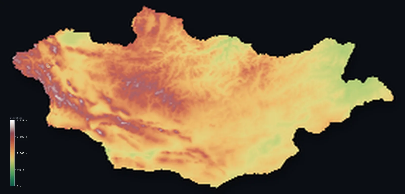
Mongolia’s highest point is Khuiten Peak at 14,350 ft (4,374 m); its lowest is Hoh Nuur at 1,837 ft (560 m); the mean elevation is 4,875 ft (1,486 m).
Mongolia is a vast, high, dry country — a great plateau of steppe, mountain, and desert in the heart of Asia, landlocked between Russia and China. Most of it is high, open grassland and semi-desert lying well above 1,000 m, rising in the west and north into real mountains — the Altai along the western border, holding the high point Khüiten Peak at 14,350 ft (4,374 m), and the forested Khangai and Khentii ranges — and falling in the south into the Gobi Desert. It is a genuinely high country — a raised plateau from end to end — and among the most sparsely peopled countries on Earth.
- Highest point📚
- 14,350 ft4,374 m
- Mongolia's highest point is Khüiten Peak at 14,350 ft (4,374 m), in the far west in the Altai Mountains — at the meeting point of Mongolia, Russia, and China, a glaciated summit in the Tavan Bogd massif. Its summit stands right at the border; the highest ground within Mongolia proper lies just below it. It is the high point of the Altai, the mountainous western corner of an otherwise high, open country.
- Lowest point📚
- 1,837 ft560 m
- Mongolia's lowest point is the lake Hoh Nuur in the east at about 1,837 ft (560 m) — and even this, the lowest ground in the whole country, lies well above 1,500 ft: Mongolia is a high plateau throughout, with no genuinely low land anywhere.
- Mean elevation⚙
- 4,875 ft1,486 m
- Computed from the GLO-30 model, Mongolia's mean elevation is 4,875 ft (1,486 m) — high, and a true measure of a country that is essentially one vast elevated plateau: high steppe and semi-desert across the centre and east, mountains in the west and north, and the Gobi in the south, with no low ground at all.
- Median elevation⚙
- 4,505 ft1,373 m
- Half of Mongolia lies above about 4,505 ft (1,373 m) — a high median reflecting the plateau's consistency: most of the country is high steppe, desert, and upland lying above 1,000 m, with the mountains higher still and no real lowland to bring the middle down.
- Elevation range📚
- 12,513 ft3,814 m
- From the lake Hoh Nuur at 560 m to the summit of Khüiten Peak at 4,374 m, Mongolia's terrain spans about 12,500 ft — but the whole of it is high: even the base of that range, the lowest lake, sits above 1,500 ft, and the country rises from high plateau to high mountains, never to lowland.
- Above 1,000 m (3,281 ft)⚙
- 83%
- About 83% of Mongolia rises above 1,000 m (3,281 ft) — most of the country, since the whole land is a high plateau. Much of the Gobi and the eastern steppe lies above that line too; only the lower eastern basins and some valley floors fall below.
- Above 2,000 m (6,562 ft)⚙
- 17%
- Roughly 17% of Mongolia stands above 2,000 m (6,562 ft) — much of the west and the mountain country, the Altai, Khangai, and Khentii ranges and the higher plateau around them, though the eastern steppe and the Gobi are somewhat lower.
- Official area📚
- 603,908 mi²1,564,116 km²
- Mongolia covers about 604,000 sq mi (1,564,116 sq km) — a vast, landlocked country in central-eastern Asia between Russia and China, a high plateau of steppe, mountains, and desert, and one of the most sparsely populated countries in the world.
- Forest cover📚
- 9.1%
- About 9% of Mongolia is forested — not much, and confined mostly to the northern mountains, the Khangai and Khentii, where forest meets the southern edge of the Siberian taiga; the steppe, the semi-desert, and the Gobi that make up most of the country are open and treeless.
Highest and lowest points
Mongolia's highest point is Khüiten Peak, 14,350 ft (4,374 m), in the far west in the Altai Mountains, at the Tavan Bogd — 'Five Saints' — massif where the borders of Mongolia, Russia, and China meet. It is a glaciated summit, one of the few permanently ice-clad peaks in the country, and its actual summit stands right on the international border; the highest ground fully within Mongolia lies just below it. Khüiten is the high point of the Altai, the rugged, glaciated western corner of a country that is otherwise high, open plateau — mountains rising from grassland at the edge of one of the emptiest expanses on Earth.
source ↗Mongolia's lowest point is the lake Hoh Nuur, in the eastern steppe, at about 1,837 ft (560 m) above sea level — and it is a striking measure of the country that even this, its lowest ground, stands higher than the highest point of many nations. Mongolia is a high plateau from end to end: landlocked, far from any sea, it has no low country at all, its rivers draining either north toward Siberia and the Arctic or inward to closed basins and salt lakes that have no outlet to the ocean.
source ↗Khuiten Peak is a border summit: its peak lies just outside the generalized Mongolia boundary, so the highest fully in-territory land pixel in the model is 14,242 ft (4,341 m). The headline figure above is the surveyed elevation of the recognised national high point.
Mongolia at a glance
Mongolia's lowest point, Hoh Nuur, still lies about 560 m above sea level — the country is a high plateau, with a mean elevation around 1,486 m higher than the summit of many nations.
source ↗Its highest point, Khuiten Peak (4,374 m), carries the Potanin Glacier and stands where Mongolia, China and Russia nearly meet.
source ↗Khuiten means 'cold' - the peak is snow-covered year-round, and the Mongolia-China border runs right across its summit.
source ↗The Gobi is mostly gravel plains and dry steppe rather than sand dunes, and is one of the world's great cold deserts.
source ↗Mongolia is the world's most sparsely populated sovereign country, its few people spread across vast steppe and desert.
source ↗It is a huge interior plateau far from any sea — its rivers drain north to the Arctic, east to the Pacific, or inward to closed basins that never reach the ocean.
source ↗
Elevation profile of Mongolia
The largest share of land, 23%, falls in the 1,000–1,250 m band, and 100% of the territory lies above 500 m (1,640 ft).
- 500–1,000 m17%
- 1,000–2,000 m66%
- above 2,000 m (6,562 ft)17%
Highest peaks of Mongolia
| Peak | Elevation | Range | Note |
|---|---|---|---|
| Khuiten Peak↗ | 14,350 ft4,374 m | Altai Tavan Bogd (far west) | Highest point of Mongolia, the glacier-capped apex of the Tavan Bogd massif on the China border. |
| Sutai Uul↗ | 13,845 ft4,220 m | Mongol Altai (southwest) | A glaciated peak of the Mongol Altai near the edge of the Gobi-Altai. |
| Tsambagarav↗ | 13,665 ft4,165 m | Mongol Altai (west) | An ice-capped massif of the western Altai near Khovd. |
| Tavan Bogd Peak (Nairamdal)↗ | 13,392 ft4,082 m | Altai Tavan Bogd (far west) | The peak marking the Mongolia-Russia-China tripoint, just north of Khuiten. |
| Otgontenger↗ | 13,150 ft4,008 m | Khangai Mountains (central) | The highest peak of the central Khangai range, a sacred glaciated summit. |
Mongolia: the western mountains, the steppe, and the Gobi
The western and northern mountains
Mongolia's high ground is in the west and north — the Altai Mountains along the western border, holding the glaciated Khüiten Peak, and the forested Khangai and Khentii ranges of the north-centre. Rugged, high, and in places snow-capped, they are the country's mountain country, the Khangai and Khentii carrying its main forests.
The steppe (the centre and east)
Across the centre and east of Mongolia stretches the great steppe — vast, high, open grassland and rolling plateau, lying well above 1,000 m, the classic Mongolian landscape of endless horizons that has sustained nomadic herders for millennia. High, dry, and treeless, it is the heart of the country.
The Gobi Desert (the south)
Southern Mongolia is the Gobi — a vast, high, cold desert of gravel plains, bare rock, and sparse scrub reaching into China, one of the great deserts of Asia. Higher and colder than most deserts, and far from empty of life, it is the dry southern third of the country.
How to read this map
Color shows elevation; the raised relief shows real terrain. On this map Mongolia reads as a high plateau tilted from its mountainous west — the browns and whites of the Altai along the western border (highest at Khüiten Peak) and the Khangai and Khentii ranges of the north, easing east and south into the high steppe and the Gobi, all of it elevated, none of it truly low.
The 3D relief is the actual GLO-30 elevation data, exaggerated vertically so the western mountains and the plateau both show; the ×N relief slider controls how much. Tap anywhere to read that point's exact elevation.
City elevations in Mongolia
Mongolia's few cities sit on the high steppe and in the valleys — Ulan Bator, the capital, in a north-central valley near the Khentii; Erdenet and Darhan in the north; Khovd, Ulaangom, and Ölgii in the western Altai; Choibalsan in the eastern steppe. All lie high, on the plateau; the country is among the most sparsely peopled on Earth.
| City | Population | Elevation |
|---|---|---|
| Ulan Batorcapitalthe capital, in a valley of the north-central plateau near the Khentii Mountains ↗ | 844,818 | 4,213 ft1,284 m |
| Erdenetin the north, a mining city ↗ | 97,814 | 4,281 ft1,305 m |
| Darhanin the north, near the Russian border ↗ | 83,883 | 2,247 ft685 m |
| Choibalsanin the eastern steppe ↗ | 44,835 | 2,444 ft745 m |
| Mörönin the north, near Lake Khövsgöl ↗ | 39,404 | 4,196 ft1,279 m |
| Bayanhongorin the centre-south, toward the Gobi-Altai ↗ | 30,931 | 6,161 ft1,878 m |
| Ulaangomin the far west, in the Great Lakes basin ↗ | 30,092 | 3,071 ft936 m |
| Khovdin the far west, below the Mongol Altai ↗ | 29,800 | 4,583 ft1,397 m |
| Arvayheerin the centre, on the high steppe ↗ | 29,420 | 6,027 ft1,837 m |
| Ölgiiin the far west in the Altai, near the Khüiten tripoint ↗ | 28,400 | 5,633 ft1,717 m |
Elevation sampled at each city centre from the Copernicus GLO-30 model. Cities and population from GeoNames (CC-BY 4.0).
Mongolia in comparison
Mongolia's terrain rises 12,513 ft (3,814 m) from Hoh Nuur (1,837 ft (560 m)) to Khuiten Peak — about 43% of the height of Mount Everest, the world's highest point at 29,032 ft (8,849 m).
- Kazakhstan's mean elevation is 1,178 ft — 3,698 ft lower; its high point, Khan Tengri, reaches 22,999 ft (7,010 m), 8,648 ft above. Kazakhstan elevation map →
- China's mean elevation is 6,014 ft — 1,138 ft higher; its high point, Mount Everest (Qomolangma), reaches 29,032 ft (8,849 m), 14,682 ft above. China elevation map →
- Russia's mean elevation is 1,148 ft — 3,727 ft lower; its high point, Mount Elbrus, reaches 18,510 ft (5,642 m), 4,160 ft above. Russia elevation map →
Frequently asked questions
What is the highest point in Mongolia?
- Khüiten Peak, 14,350 ft (4,374 m), in the Altai Mountains of the far west, where Mongolia, Russia, and China meet — a glaciated summit on the border, with the highest ground fully inside Mongolia just below it.
What is the lowest point in Mongolia?
- The lake Hoh Nuur in the east, at about 1,837 ft (560 m) — and even this, the country's lowest ground, stands well above 1,500 ft, as Mongolia is a high plateau throughout.
What is the average elevation of Mongolia?
- Computed from the Copernicus GLO-30 model, the area-weighted mean is 4,875 ft (1,486 m) — high, because Mongolia is one vast elevated plateau of steppe, mountain, and desert, with no low ground at all.
Is Mongolia mountainous?
- In part — the Altai in the west and the Khangai and Khentii in the north are real mountains, but most of Mongolia is high steppe and the Gobi Desert. The whole country is a high plateau, none of it truly low.
What is the Gobi Desert?
- A vast, high, cold desert across southern Mongolia and into China — gravel plains, bare rock, and sparse scrub, one of the great deserts of Asia, higher and colder than most.
Is this a topographic, relief, contour, or elevation map of Mongolia?
- They describe the same thing — terrain height. This page renders the country's actual elevation surface in interactive 3D and reports the statistics computed from it.
About this map
The terrain is rendered from the Copernicus GLO-30 digital elevation model (ESA), masked to the MNG-ADM0 boundary from geoBoundaries (gbOpen). Elevation statistics are computed directly from the model; peak names and researched facts are sourced and cited. See the methodology for the full pipeline.
Our area-weighted mean, computed from the Copernicus GLO-30 model, is 4,875 ft (1,486 m); the figure commonly cited elsewhere is 5,013 ft (1,528 m) (CIA World Factbook). Mongolia is essentially one vast elevated plateau — high steppe, mountain, and the high Gobi, with no low ground at all — so its area-weighted mean is high. The figure computed here from the Copernicus GLO-30 model is about 1,486 m; the CIA World Factbook cites 1,528 m.
Surveyed national figures: official area · forest cover · high point.
Rendered from Copernicus GLO-30 (ESA, 2021 release), boundaries from geoBoundaries. Generated 2026-06-24.
Bordering countries · 2
Mongolia shares a land border with these countries — open any one to compare its terrain and highest point.